| | Thumbnail | | Creator | Date | Title / Author / Date / Location | Price | | | Description |
| 208 | 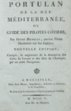 | Details | Michelot and Bremond | 1805 |
| Portulan de la Mer Méditerranée |
|
Michelot and Bremond |
|
| 1805 |
| LOC:0 |
| $600.00 | Michelot-and-Bremond | Portulan-de-la-Mer-Méditerranée | Very rare antique edition of this book of sailing directions by Henry Michelot whose earliest career with Louis XIV's Corp des Galeres (Galley Corps) dates to approximately 1675. This edition published in French by Jean Mossy in 1805 is updated with sailing directions for the Levant coast and Greek Archipelago not found in the original 1703 edition. <BR> </BR>
For the collector of <a rel="nofollow" href= "/MichelotBremondBackground.aspx">Michelot and Bremond sea charts</a> this volume provides fascinating background and depth into their early works. 596 pages including an index. Includes a preface by Mossy. No maps or illustrations (as issued). |
| 401 |  | Details | Dupin, Charles | 1819 |
| Ports of England, Scotland, and Ireland |
|
Dupin, Charles |
|
| 1819 |
| LOC:0 |
| $125.00 | Dupin--Charles | Ports-of-England--Scotland--and-Ireland | Charles Dupin (1784-1873) a French mathematician and naval engineer. Observation of this French engineer during visits to the major ports in England. Contains extensive sections describing the state and construction of the Plymouth harbor breakwater and the Caledonian canal.<BR> </BR>
Contains an engraved sketch of "Plymouth Sound and Breakwater (7"x7") and a hand-colored plan and transverse section of the Plymouth Sound breakwater (4"x8").<BR> </BR>
London: Printed for Sir Richard Phillips and Co. Bride-court, Bridge-street. 1819.<BR> </BR> |
| 1192 | 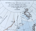 | Details | Manby, George William | 1823 |
| Journal of a Voyage to Greenland, in the year 1821 |
|
Manby, George William |
|
| 1823 |
| LOC:0 |
| $1,200.00 | Manby--George-William | Journal-of-a-Voyage-to-Greenland--in-the-year-1821 | An arctic whaling classic. Scarce second edition (1823) of this illustrated account of the whaling ship Baffin’s voyage with Captain Scoresby. The main purpose of the voyage was to test a new harpoon design by Scoresby. The voyage took them first to Spitzbergen, along the coast of Greenland, to Iceland and then home.
<br></br>
George Manby accompanied Captain Scoresby on the voyage into the northern Greenland Sea aboard the whaling ship Baffin. Manby creates a vivid picture of Arctic whaling as it was practiced during the early part of the 19th Century. Scoresby invented a harpoon gun and is also remembered for his life-saving apparatus. Numerous woodcuts in the text of whales, narwhal, and other arctic creatures.
<br></br>
With a fine hand-colored folding map "A General Map of the Polar Ice in the Greenland Sea and Track of the Ship Baffin in the Summer of 1821 by G.W. Manby (14" x 10"). Contains 20 uncolored lithographic plates illustrating the voyage. Five plates "Drawn on stone by J.D. Harding" are larger and folded:
<div class="indenttextblock">
<ul style="list-style-type: circle;">
<li>Striking a Whale with Third Harpoon</li>
<li>A Whale Upsetting a Boat</li>
<li>Lancing a Whale</li>
<li>A Bear Attacking A Boat</li>
<li>A Boat Going on the Tail of a Fish</li>
</ul>
</div>
In 1819 William Scoresby moved to Liverpool from Whitby where he built (1820) and commanded the whaling ship "Baffin". In 1822 Scoresby mapped the East coast of Greenland. The "Baffin" finally sank in 1830 when 19 out of 90 ships in the whaling fleet were lost in bad weather in the Davis Strait. Scoresby's plans, together with this scale model of his ship are in the Whitby Museum, Yorkshire, England.<a href="http://www.whitbymuseum.org.uk/hpmimages/index1.htm " target="_blank"> (Internet. 2016.)</a>
<br></br>
Printed for G. and W.B. Whittaker, Ave Maria Lane, London. 225 pages including an appendix illustrated with woodcuts of harpoons and lance heads. |
| 399 | 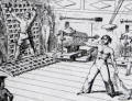 | Details | Barker, Matthew Henry | 1826 |
| Greenwich Hospital |
|
Barker, Matthew Henry |
|
| 1826 |
| LOC:0 |
| $400.00 | Barker--Matthew-Henry | Greenwich-Hospital | Collection of humorous nautical tales written by Matthew Barker and illustrated by George Cruikshank. Eleven etched plates and sixteen text woodcuts. Marbled boards. London: James Robins and Co., 1826 |
| 1257 |  | Details | Corporation of Trinity House | 1849 |
| Antique Booklet for the Trinity House School in Hull for the Sons of Seamen |
|
Corporation of Trinity House |
|
| 1849 |
| LOC:0 |
| $195.00 | Corporation-of-Trinity-House | Antique-Booklet-for-the-Trinity-House-School-in-Hull-for-the-Sons-of-Seamen | Very scarce 14-page booklet containing the Rules and Regulations for the Marine School operated at Kingston-Upon-Hull by the <b>Trinity House</b> for the education of the sons of seamen from that port. On period wove paper.
<br></br>
The Trinity House was originally a guild of shipmen and mariners established by Henry VIII in 1517 to support and expand shipping in England. Later the Trinity House was tasked with maintaining buoys, lighthouses, and aids to navigation on the English coast as well as licensing ship's pilots. (Oxford Companion to Ships and The Sea, Peter Kemp, ed. Oxford University Press. London, 1976, p. 889.)
<br></br>
Printed in 1849 for R.T. Cussons, Lowgate, Hull. |
| 515 | 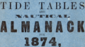 | Details | Pearson, George | 1874 |
| G. Pearsons General Tide Tables and Nautical Almanack for 1874 |
|
Pearson, George |
|
| 1874 |
| LOC:0 |
| $75.00 | Pearson--George | G--Pearsons-General-Tide-Tables-and-Nautical-Almanack-for-1874 | Small, scarce, 19th century nautical almanack published from Hartlepool, England. Blue paper covers. |
| 775 |  | Details | Hunt and Company | 1886 |
| Hunts Universal Yacht List 1886 |
|
Hunt and Company |
|
| 1886 |
| LOC:0 |
| $425.00 | Hunt-and-Company | Hunts-Universal-Yacht-List-1886 | A great gift for a sailing or yachting enthusiast. Hunts Universal Yacht List for 1886 contains 29 pages of colour printed yacht club flags and colored flags for individual yawls, schooners and cutters, with over 60 pages of interesting trade advertisements (many illustrated). This scarce, compact, antique volume is the 1886 edition in a series that were published annually between 1848 and 1914. Contains a long alphabetical list of specifications for 4800 largely British yachts including the following fields: name of yacht; rig; length; beam; tonnage; depth; owners; a key to the name of one the 61 participating yacht clubs; signal letters; year built; year altered; builder; sailmaker; and distinguishing flag.
<br></br>
Includes signal flags in color along with regatta dates, a list of owners, list of agents, staff and yachts of all the principal yacht clubs of the World, tide tables, prize winners, etc.
<br></br>
Bound in the original blue cloth boards, with gilt lettering and a royal crest to the upper cover. Professionally rebacked in gilt-decorated navy-blue morocco. Publisher: London: Hunt & Co., 119 Church Street, London. 422 pages. |
| 1140 | 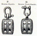 | Details | Boston and Lockport Block Company | 1890 |
| Late 19th Century Trade Catalog of Ships Blocks |
|
Boston and Lockport Block Company |
|
| 1890 |
| LOC:0 |
| $255.00 | Boston-and-Lockport-Block-Company | Late-19th-Century-Trade-Catalog-of-Ships-Blocks | Early trade catalog of ships blocks (pulleys) from a well-known U.S. manufacturer, the Boston and Lockport Block Company ca. 1890.
<br></br>
List of contents from the index includes:
<div class="indenttextblock">
<ul style="list-style-type: circle;">
<li>Blocks for rope straps</li>
<li>Dead eyes</li>
<li>Fiddle blocks for yachts</li>
<li>Jib sheet blocks for yachts</li>
<li>New style yacht blocks with wooden cheeks</li>
<li>Snatch blocks for yachts</li>
<li>Wood dock blocks</li>
<li>Wrought iron blocks</li>
</ul>
</div>
Boston and Lockport used a star as their brand mark. Many of the pages in the catalog are overprinted in yellow with a star and the phrase "Star Brand". 47 pages plus index. |
| 611 | 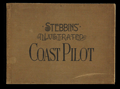 | Details | Stebbins, Nathaniel L. | 1891 |
| First Edition Stebbins' Illustrated Coast Pilot - 1891 |
|
Stebbins, Nathaniel L. |
|
| 1891 |
| LOC:0 |
| $465.00 | Stebbins--Nathaniel-L- | First-Edition-Stebbins--Illustrated-Coast-Pilot---1891 | FIRST EDITION of this antique, late 19th century landmark in coastal navigation from the famous Boston-based marine photographer Nathaniel Stebbins. An interesting late 19th century artifact that combined the (then) new technology of photography with the oldest known form of recorded navigational instructions- the <a href="https://en.wikipedia.org/wiki/Periplus">periplus</a> or book of written sailing directions.
<br></br>
Stebbin's fascinating antique coast pilot first demonstrated the practical application of photography to navigation, a field long dominated by man-made representations of coastal features. Contains numerous photographs of key landmarks and navigational aids accompanied by textual sailing directions. Among the hundreds of photographs are Stepping Stones lighthouse, Execution Rocks lighthouse, Stamford Harbor lighthouse, Bartlett Reef light vessel, Newport Harbor lighthouse, Hen and Chickens light vessel, Vineyard Sound light vessel, Hyannis wharf and range lights, Great Round Shoal light vessel (appears to be a decrepit wreck of a sailing vessel), Nantucket lighthouses at Brant Point and Great Point, and the Boston and Marblehead lighthouses. <BR> </BR>
Includes numerous interesting nautical advertisements. Covers the United States northeast from New York to Maine. <BR> </BR>
We are not aware of an earlier coast pilot containing photographic coastal images. Already scarce, this overlooked volume with a sea-worthy canvas cover belongs in the collection of all those interested in 19th century U.S. coastal charts. Numerous nautical-related advertisements scattered thoughout. The author describes this internal advertising as an effort to hold down the cost to the reader. Boston. 1st ed. |
| 2509 | 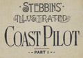 | Details | Stebbins, Nathaniel L. | 1893 |
| Stebbins' Illustrated Coast Pilot First Edition SECOND STATE |
|
Stebbins, Nathaniel L. |
|
| 1893 |
| LOC:2001 |
| $400.00 | Stebbins--Nathaniel-L- | Stebbins--Illustrated-Coast-Pilot-First-Edition-SECOND-STATE | Very rare SECOND STATE of the FIRST EDITION of this antique, late 19th century landmark in coastal navigation from the notable Boston-based marine photographer Nathaniel Stebbins. An interesting late 19th century artifact that combined the (then) new technology of photography with the oldest known form of recorded navigational instructions- written sailing directions. (See second state differences at bottom).
<br></br>
Stebbin's fascinating antique coast pilot first demonstrated the practical application of photography to navigation, a field long dominated by man-made representations of coastal features. Contains numerous photographs of key landmarks and navigational aids accompanied by textual sailing directions. Among the hundreds of photographs are Stepping Stones lighthouse, Execution Rocks lighthouse, Stamford Harbor lighthouse, Bartlett Reef light vessel, Newport Harbor lighthouse, Hen and Chickens light vessel, Vineyard Sound light vessel, Hyannis wharf and range lights, Great Round Shoal light vessel (appears to be a decrepit wreck of a sailing vessel), Nantucket lighthouses at Brant Point and Great Point, and the Boston and Marblehead lighthouses. <BR> </BR>
We are not aware of an earlier coast pilot containing photographic coastal images.
<BR> </BR>
This second state of the first edition differs from the first state as follows (see photographs):
<div class="indenttextblock">
<ul style="list-style-type: circle;">
<li>Cover title contains additional "Part I".</li>
<li>For photographs some are annotated with a purple ink overstamp: "For changes see end of book."</li>
<li>Supplement (4 pages) added near end of volume: "Corrections, additions, and changes to March 1st, 1892."</li>
<li>Single page added as the final page: "Corrections to January 1st, 1893."</li>
</ul>
</div> |
| 94 |  | Details | Pratt, William | 1896 |
| American Coast Pilot |
|
Pratt, William |
|
| 1896 |
| LOC:0 |
| $85.00 | Pratt--William | American-Coast-Pilot | 217 pages plus appendix. Manuscript signature on back blank page: "Manual V Silva, Provincetown Mass." Includes an advertisement at end for "Samuel Thaxter & Son, Manufacturers and Importers of Nautical and Optical Instruments. Charts and Nautical Books." Copyright 1883, rev.1896. Two plates. |
| 2508 |  | Details | Stebbins, Nathaniel L. | 1896 |
| Stebbins' Illustrated Coast Pilot 2nd ed. |
|
Stebbins, Nathaniel L. |
|
| 1896 |
| LOC:0 |
| $275.00 | Stebbins--Nathaniel-L- | Stebbins--Illustrated-Coast-Pilot-2nd-ed- | Important, late 19th century landmark in coastal navigation from the well-known Boston-based marine photographer Nathaniel Stebbins. Stebbins provides sailing directions and plentiful photographs of key landmarks and navigational aids, but not one map. Full coverage of U.S. East Coast and marginal coverage of the United States Gulf Coast. For the Gulf Coast a few images are actually not photographs, but drawings.
<BR> </BR>
Second scarce edition of the first Coast Pilot containing photographic coastal images. This book demonstrated the practical application of photography to navigation, a field long dominated by man-made representations of coastal features. 249 pages. 2nd ed.
<BR> </BR>
Already scarce, this overlooked volume with a sea-worthy canvas cover belongs in the collection of all those interested in 19th century U.S. coastal charts. Numerous nautical-related advertisements scattered thoughout. The author describes this internal advertising as an effort to hold down the cost to the reader. |
| 705 | 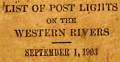 | Details | U.S. Department of Commerce and Labor | 1903 |
| List of Post Lights on the Western Rivers |
|
U.S. Department of Commerce and Labor |
|
| 1903 |
| LOC:0 |
| $165.00 | U-S--Department-of-Commerce-and-Labor | List-of-Post-Lights-on-the-Western-Rivers | Small, antique, pocket size book of lights on all the U.S. Western Rivers corrected to September 1903. Lights are grouped into three sections by Lighthouse District each with a sectional title page. The 3 book sections are:
<div class="indenttextblock"><ul>
<li>Fourteenth District: List of Lights on the Ohio, Kanawa, and Tennessee Rivers.</li>
<li>Fifteenth District: List of Lights on the Mississippi (above Cairo, Ill.) Missouri, and Illinois Rivers.</li>
<li>Sixteenth District: List of Lights on the Mississippi (Below Cairo, Ill.) and Red Rivers.</li></ul></div>
Format is the same throughout: the left page header contains the river name and the starting point from which river channel mileage is measured. Detail columns on left pages capture the light number, official light name, distance from the starting point, side of channel, and color of light. Right facing pages are ruled and blank for use of the reader to record notes; the header reads: "Remarks, Changes, Etc."
<br></br>
Each sectional title page bears a request to readers for help in identifying lights with usability issues: <div class="indenttextblock">"Pilots and all masters are particularly requested to report to the Light-House Inspector at Cincinnati, Ohio, lights which are out or dim or burning during the day; also changes in location of lights required, using the official name and number of the light. Pilots are also requested to blow their whistles when a light is out to notify the keeper."</div>
The Ohio River distances are measured from Pittsburg, Pennsylvania; Kanawa River distances from Point Pleasant; Tennessee River Distances from Paducah, Kentucky; Upper Mississippi River distances from St. Paul, Minnesota; Lower Mississippi River distances are measured starting from Cairo, Illinois.
<br></br>
A few user manuscript pencil entries of birthdays and other notes on the first few notes pages. 253 pages total. |
| 516 | 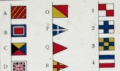 | Details | His Majesty's Stationery Office | 1908 |
| Signal Card 1908 |
|
His Majesty's Stationery Office |
|
| 1908 |
| LOC:205 |
| $95.00 | His-Majesty-s-Stationery-Office | Signal-Card-1908 | Small 4-page lithographed publication on 3 bound, heavy cards detailing signals used by Britain's naval forces: signal flags and pendants, semaphore, Morse signs, and flashing signs. HMSO, a commercial entity operated by the British government, was founded in 1786 to reduce costs by consolidating printing for the empire. Printed by M’Lagan and Cumming, Edinburgh. Price three pence. |
| 5219 |  | Details | International Navigation Congress | 1908 |
| Report of the 11th meeting of the International Navigation Congress |
|
International Navigation Congress |
|
| 1908 |
| LOC:2001 |
| $100.00 | International-Navigation-Congress | Report-of-the-11th-meeting-of-the-International-Navigation-Congress | Scarce booklets (24) of reports for the 11th meeting of the International Navigation Congress or Association Internationale Permanente de Congres de Navigation, held in St. Petersburg, Russia during 1908. Some reports with folding plates. Authors of these reports represent a diverse set of countries including but not limited to: Germany, England, Belgium, Russia, France, Italy, and the United States.
<br></br>
Contents include booklets in French or English text (some with engineering or hydrographic plates). The topics are related to five broad areas of interest:
<div class="indenttextblocksingle">
<ul style="list-style-type: circle;">
<li>Fishing ports and harbors for coastal maritime trade.</li>
<li>Economic and engineering studies for Inland maritime ports.</li>
<li>Port construction on sandy beaches.</li>
<li>General conditions for secure maritime navigation.</li>
<li>Hydrographic exploration of the seas.</li>
</ul>
</div>
Hard cover binder secured by string closures with 24 reports, each staple bound with paper covers. Some booklets bear the oval stamp of the Liverpool Engineering Society. |
| 88 |  | Details | Wilson, Elen | 1937 |
| The Story of the Blueback Chart |
|
Wilson, Elen |
|
| 1937 |
| LOC:2001 |
| $65.00 | Wilson--Elen | The-Story-of-the-Blueback-Chart | Booklet contains a brief history and chronology of the old chart publishing firm of Imray as far back as John Seller and John Senex. Self-published complimentary brochure with softcover and string binding. 20 pages plus illustrations. |
| 488 |  | Details | Haffenreffer, R.F. | 1940 |
| Yachts by Herreshoff |
|
Haffenreffer, R.F. |
|
| 1940 |
| LOC:0 |
| $150.00 | Haffenreffer--R-F- | Yachts-by-Herreshoff | Promotional book by the Herreshoff Manufacturing Company, Bristol, Rhode Island ca. 1940. Contains eight color reproductions of America's Cup race winners built by Herreshoff, after drawings by R.F. Paterson. These classic vessels designed by Nathanael G. Herreshoff or W. Starling Burgess include the Vigilant, Defender, Columbia (2), Reliance, Resolute, Enterprise and Rainbow. A "Roll of Honor" for these successful America's Cup defenders on page 47 shows that the boats were owned by many of the business leaders of the early 20th century including Cornelius Vanderbilt, Vincent Astor, Alfred Sloan, J.P. Morgan, and Walter Chrysler, among others.
<BR> </BR>
With numerous other black and white photographs of Herreshoff-built boats and manufacturing processes. Contains plans and specifications on glassine paper for eight smaller Herreshoff one-design class offerings from 11 to 31 feet. Table of Contents and Registry of Owners.
<BR> </BR>
Number 8741 presented to J.G. Sheldon. 53 pages as issued. |
| 726 | 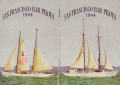 | Details | San Francisco Bar Pilots | 1944 |
| San Francisco Bar Pilots Tide Tables 1944 |
|
San Francisco Bar Pilots |
|
| 1944 |
| LOC:0 |
| $90.00 | San-Francisco-Bar-Pilots | San-Francisco-Bar-Pilots-Tide-Tables-1944 | Very cool pocket reference book issued by the San Francisco Bar Pilots in 1944, while the U.S.A. was still deeply invloved in WWII. Card stock cover with photos of two of three pilot vessels working that port, both with sails: California #7, and the well-known schooner Gracie-S. #3. The Gracie-S was built by Union Iron Works of San Francisco and delivered to her original owners in December 1893 . She was 86 gross tons and 83 ft in length at the waterline, a rather large vessel for a pilot boat, but stong and comfortable with a total of twelve berths. This booklet shows she was still in service more than 50 years later. (Source: Pilots: Pilot Schooners of North America and Great Britain. Tom Cunliffe Ed. WoodenBoat publications. Brooklin, Maine. 2001. pp. 225-229.)
<br></br>
Contents include information on: sunrise and sunset times, pier locations in San Francisco, bridge heights, distances between ports, whistle calls and telephone numbers for harbor tug, tow boat, customs office, etc., names, addresses and home telephone numbers for all the bar pilots, tide tables, and a map at the center showing the channel back into San Pablo Bay and Suisun Bay.
<br></br>
The <a href="http://sfbarpilots.com/">San Francisco Bar Pilots web site</a> notes that the pilots of that organization have performed a demanding job guiding vessels in that challenging environment for more than 1.5 centuries:
<div class="indenttextblock">For more than 160 years, the San Francisco Bar Pilots have been guiding the world’s largest ships through some of North America’s most difficult waterways. Every day, the state-licensed Bar Pilots navigate commercial ships to and from the nine ports within San Francisco Bay and the Port of Monterey… With extreme care, the Bar Pilots deliver passengers, agricultural products, manufactured goods and hazardous materials throughout the Bay as far south as Redwood City, and as far inland as the Ports of Stockton and Sacramento.</div> |
| 886 |  | Details | Guthorn, Peter | 1984 |
| U.S. Coastal Charts 1783-1861 |
|
Guthorn, Peter |
|
| 1984 |
| LOC:0 |
| $25.00 | Guthorn--Peter | U-S--Coastal-Charts--1783-1861 | Must-have reference guide for those interested in early nautical cartotgraphy of the U.S. coast. Numerous photographs and descriptions of coastal charts including blueback charts by historian Peter Guthorn make this a singular valuable resource for both collectors and researchers.
<br></br>
The Table of Contents includes:
<br></br>
<DL>
<DT><STRONG>The Private Publishers</STRONG>
<DD> > Matthew Clark
<DD> > John and William Norman
<DD> > Thomas Coles
<DD> > Jonathan Price
<DD> > John Strother
<DD> > Samuel Lambert
<DD> > Richard Patten
<DD> > Charles Copley
<DD> > George Eldridge
<DT><STRONG>Charting by the Army</STRONG>
<DT><STRONG>Charting by the Navy</STRONG>
<DT><STRONG>The Coast Survey</STRONG>
</DL> |