| | Thumbnail | | Creator | Date | Title / Author / Date / Location | Price | | | Description |
| 6759 |  | Details | Clary, A. D. | |
| Pictorial map San Joaquin Power Club Wishon Cove Camp |
|
Clary, A. D. |
|
|
| LOC:89 |
| $250.00 | Clary--A--D- | Pictorial-map-San-Joaquin-Power-Club-Wishon-Cove-Camp | You have heard about "Where's Waldo?" but on this map I ask: "Where's Kilroy?"
<br><br>
An original post-WWII pictorial map of Wishon Cove Camp at Wishon Cove on Bass Lake in Crane Valley, California <b>featuring Kilroy</b> (1). Subtitled "San Joaquin Power Club", apparently this camp was originally a private club for the San Joaquin Power Company. Today the camp is run by the Pacific Service Employees Association.
<br><br>
The map shows hikers, horse-back riders, dancers, hunters, boaters, Boy Scouts, fishermen, and swimmers, all enjoying themselves outdoors on what appears to be some steep slopes. McDougald's store is located next to the shoreline and red-roofed Sam's Place seems to be the local watering hole, surrounded by apartments, dormitories, and numerous outhouses. The camp was named after businessman Arthur Wishon.
<br><br>
Arthur Emory Wishon, often known as A. Emory Wishon, was a pioneering figure in the development of hydroelectric power in California, using Bass Lake water. He served as a chief engineer and later as a vice president for San Joaquin Light and Power Corporation. His work significantly contributed to the construction of multiple dams and power plants in the region.
<br><br> |
| 425 | 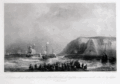 | Details | Gudin, Baron Theodore | |
| D'Espineville de Harfleur brule une flotte Hollandaise |
|
Gudin, Baron Theodore |
|
|
| LOC:89 |
| $90.00 | Gudin--Baron-Theodore | D-Espineville-de-Harfleur-brule-une-flotte-Hollandaise | This engraving depicts a battle in 1555 between twenty-two Dutch warships and twenty-five French off Dover in the English channel. During the battle five French vessels were set on fire. French crews jumped overboard and swam to the nearest vessel for safety, whether friend or foe. The Dutch recovered so many French sailors that it was impossible to guard them thoroughly, the result of which was that the rescued French sailors overpowered and captured five Dutch vessels and brought them as prizes to Dieppe. In all, 1000 Dutch and 400 French sailors are thought to have perished (although Dutch sources disagree). The French Admiral, d'Espineville was one of the casualties. <BR> </BR>
This fine work from the original 19th century plate, is a 20th century reprint from the Louvre of an etching and engraving on steel plate by Chavane. Subject matter is based on a painting by French Marine Painter Baron Theodore Gudin (1802-1880 ) in 1839. <BR> </BR>
With the circular embossed stamp of "Chalcographie Musee National du Louvre". La Chalcographie du Louvre is a repository of more that 13,000 plates from the Louvre's archives, housed upstairs above the Louvre's Paris galleries . Upon request visitors can have a engraving produced from one of those original plates by master printers on museum-quality paper. |
| 4800 | 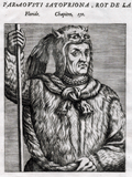 | Details | Thevet, Andre | 1584 |
| Portrait of the King of Florida Paraousti Satouriona |
|
Thevet, Andre |
|
| 1584 |
| LOC:87 |
| $450.00 | Thevet--Andre | Portrait-of-the-King-of-Florida-Paraousti-Satouriona | Fine antique portrait of Paraousti Satouriona, styled the <b>"King of Florida",</b> and dressed in a thick animal skin, wearing a head-dress made from what is apparently the skull and head of a lynx, with the front legs and claws stylishly knotted about the King's neck.
<BR> </BR>
This scarce engraving comes from "Les vrais pourtraits et vies des hommes illustres grecz, latins et payens" by Andre Thevet. That source contained a collection of over two hundred portraits and biographies of subjects such as Montezuma, Atahualpa, Cortez, Paracoussi "Roy du Platte", and this Paraousti Satouriona the "Roy de La Floride" .
<BR> </BR>
Andre Thevet, born around 1516, became a Franciscan friar and wrote extensively about his travels in both the old world and new, widely embellishing the stories and images with myth and fiction.
<BR> </BR>
French text on verso and recto. Page 661. |
| 496 | 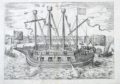 | Details | Hogenberg, Franz | 1585 |
| Fin de La Guerre (warship) |
|
Hogenberg, Franz |
|
| 1585 |
| LOC:1 |
| $295.00 | Hogenberg--Franz | Fin-de-La-Guerre-(warship) | Copperplate-engraved oblique profile of the Dutch fighting ship "Fin de la Guerre". This large fortress-like, four masted ship saw action at the battle of Antwerp in 1585. The engraving is notable because the ship is much like a U.S. Civil war monitor or WWI battleship with a design emphasis on firepower and protection for the fighting forces. The vessel is shown firing cannon as it is attacked by smaller vessels including at least one small galley or galliot. Lacks the explanatory text found in other versions of the print… possibly a later version. Attributed to Hogenberg and Michael Aitzinger. |
| 171 |  | Details | Anonymous | 1600 |
| Des Dieux |
|
Anonymous |
|
| 1600 |
| LOC:0 |
| $50.00 | Anonymous | Des-Dieux | Fanciful antique woodblock engraving of a small galley. French text at bottom and verso. Vines cover the mast, oars and rudder and several lions are seen on deck while in the foreground two sea creatures swim menacingly. Ca 1600. Unknown origin. Page 543. |
| 5131 | 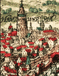 | Details | Baudartius, Willem | 1616 |
| Hantwerpia |
|
Baudartius, Willem |
|
| 1616 |
| LOC:13 |
| $150.00 | Baudartius--Willem | Hantwerpia | Antique copper-plate engraving of a battle between the Spanish and the Dutch during the 80 Years War. The 15-gun Black Galley of Dordrecht defeated eight Spanish ships on the Schelde / Scheldt river at Antwerp, 29 November 1600.
<br></br>
Published in Amsterdam by M. Colin de Thovoyon in 1616 in 'Les guerres de Nassau' by Willem Baudartius. |
| 5374 | 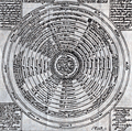 | Details | Millot, Philippe | 1620 |
| Rare celestial diagram by engraver Philippe Millot. |
|
Millot, Philippe |
|
| 1620 |
| LOC:13 |
| $550.00 | Millot--Philippe | Rare-celestial-diagram-by-engraver-Philippe-Millot- | Rare celestial diagram signed by French master engraver Philippe Millot ca 1620: "Totius Corporeæ Machinæ ex 12 Coelis et 4 Elementis Compactæ Descriptio." Folio 98.
<br></br>
No copy of this item is found online. Latin text. |
| 660 |  | Details | Tassin, Christophe Nicholas | 1634 |
| Cartes Generale et Particulieres de toutes le costes de France |
|
Tassin, Christophe Nicholas |
|
| 1634 |
| LOC:1 |
| $475.00 | Tassin--Christophe-Nicholas | Cartes-Generale-et-Particulieres-de-toutes-le-costes-de-France | Extraordinary engraved and very scarce 13" x 9" sea-atlas title page by French cartographer Christophe Nicholas Tassin. Contains scrollwork, angels, garlands, and a flat frog-like creature. A beautiful example of 17th century copperplate engraved art. This title page is not from the common series of town views in pocket atlas format published by Tassin.
<br></br>
This title page is from the earliest sea atlas published in France ( 1634 ) by Christophe Tassin. That atlas of 32 plates depicts hydrographic and topographic details of the French coast.
<br></br>
See this site for charts in Tassin's rare atlas: http://gallica.bnf.fr/ark:/12148/btv1b77100033.
<br></br>
Attribution at bottom reads: "Par Sieur Tassin Geographe ordinaire de ca Majeste. Par Privilege du Roy." Tassin's background was as a military engineer. Tassin's work contains topographic maps, often of militarily important sites, either sketched on site, composed from firsthand drawings by military engineers, or sometimes borrowed from other mapmakers. Additionally, Christophe Tassin also published several small sized atlases with profiles of French towns and maps of the provinces.
<br></br>
Published in Paris by Chez Melchior Tavernier, en lisle du Palais, vis à vis la quay de la Megisserie. |
| 999 |  | Details | Tassin, Christophe Nicholas | 1636 |
| Antique title page for Dauphiné province in France |
|
Tassin, Christophe Nicholas |
|
| 1636 |
| LOC:50 |
| $95.00 | Tassin--Christophe-Nicholas | Antique-title-page-for-Dauphiné-province-in-France | Beautiful hand-colored, engraved sectional title page for Tassin's small atlas of French towns. This example is for the chapter containing the province of Dauphiné, in southeastern France. This title page with its scrollwork cartouche is topped with a whimical insect head. A very fine example of 17th century engraving craftsmanship and artistry.
<br></br>
Published in the small-sized atlas "Les Plans et profils de toutes les principales villes et lieux considerables de France" by Christophe Nicholas Tassin (d. 1660) . Tassin's background was as a military engineer, and he is best known for his nautical atlas of 30 sheets, dedicated to Richelieu, documenting France's coastline. Tassin's work contains topographic maps, often of militarily important sites, either sketched on site, composed from firsthand drawings by military engineers, or sometimes borrowed from other mapmakers. |
| 149 | 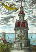 | Details | Tassin, Christophe Nicholas | 1636 |
| Tour de Corduan |
|
Tassin, Christophe Nicholas |
|
| 1636 |
| LOC:0 |
| $350.00 | Tassin--Christophe-Nicholas | Tour-de-Corduan | <b>A recommended item</b> for any collector of maritime, lighthouse, or nautical antiques. Should appeal to collectors of coastal charts of France. Very unusual and quite interesting engraving from Tassin who produced almost exclusively charts and plans of the French coast and little else.
<br></br>
Extremely scarce antique view of the lighthouse "Tower of Corduan" ca. 1636 after an earlier work by Claude Châtillon in 1612. The "Tour de Corduan" is the oldest lighthouse in France and one of the oldest lighthouses in the world. The structure was completed in 1611, more than 35 years after its initial design by Louis de Foix.
<br></br>
Sometimes called the King of Lighthouses because of its large size and extravagant construction details, Le Phare Corduan marks the entrance to the Gironde river near Royan, France. As is common with Tassin engravings numerous sailing vessels are shown offshore the lighthouse, with one firing a blast from its cannon.
<br></br>
Published in the small-sized atlas "Les Plans et profils de toutes les principales villes et lieux considerables de France" by Christophe Nicholas Tassin (d. 1660) . Tassin's background was as a military engineer, and he is best known for his nautical atlas of 30 sheets, dedicated to Richelieu, documenting France's coastline. Tassin's work contains topographic maps, often of militarily important sites, either sketched on site, composed from firsthand drawings by military engineers, or sometimes borrowed from other mapmakers. |
| 987 | 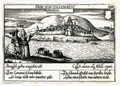 | Details | Meisner, Daniel | 1637 |
| Antique birds-eye view of Buarcos, Portugal |
|
Meisner, Daniel |
|
| 1637 |
| LOC:7 |
| $120.00 | Meisner--Daniel | Antique-birds-eye-view-of-Buarcos--Portugal | Small birds-eye view of Buarcos, Portugal by Daniel Meisner from 1637. Buarcos was a fishing village and is now a key beach resort, approximately 30 miles west of Coimbra, Portugal. From Meisner's famous emblematic atlas of the European (and a few foreign) cities. This view is a combination of two popular genres - the Emblem Book and the Book of Town Plans, e.g. the Civitates of Braun and Hogenberg.
<br></br>
Here Meisner's Latin and German verses echo the motto "Dum Non Collidamini" (So long as they don't collide) describing the usefulness of earthenware jars but the peril of breaking if they are banged together, thus the imagery of the two jars floating downstream. The metaphor is extended to interpersonal relations for the man and the woman seek to avoid "collisions" as well. |
| 1042 |  | Details | Morisot, C.B. | 1643 |
| Japonese Navigum, Sinese Navigum |
|
Morisot, C.B. |
|
| 1643 |
| LOC:1 |
| $175.00 | Morisot--C-B- | Japonese-Navigum--Sinese-Navigum | Single sheet of chain laid paper with an engraved illustration of two Asian sailing vessels from an early work on maritime history by Morisot (1592-1661): "Orbis Maritimi siue Rerum in Mari et Littoribus Gestarum Generalis Historia". The vessels are titled: "Japonese Navigum" and " Sinese Navigum". Both vessels are steered via side mounted steering oars. |
| 102 | 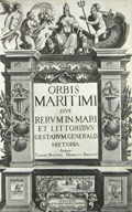 | Details | Morisot, C.B. | 1643 |
| Title Page Orbis Maritimi |
|
Morisot, C.B. |
|
| 1643 |
| LOC:50 |
| $200.00 | Morisot--C-B- | Title-Page-Orbis-Maritimi | Decorative antique title page from the first comprehensive work on maritime history by Charles Barthelemy Morisot (1592-1661) - "Orbis Maritimi siue Rerum".
<br></br>
This rare engraving is adorned with sea shells, anchors, and implements of war. Petrum Palliot, 1643. First and only edition. |
| 2496 | 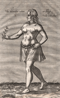 | Details | Baudier, Michel | 1659 |
| Young female Moorish slave of Algiers |
|
Baudier, Michel |
|
| 1659 |
| LOC:1 |
| $225.00 | Baudier--Michel | Young-female-Moorish-slave-of-Algiers | Scarce copperplate engraving of a young female Moorish slave (Fille moresques esclave) by Nicolas de Nicolay from "L'histoire de la décadence de l'empire grec et establissement de celuy des Turcs."
<br></br>
Nicolas de Nicolay (1517-1583), was a French geographer. In 1556 de Nicolay received the official title of "geographer of the king." In 1551, Henry II ordered Nicolas de Nicolay to follow Gabriel Aramon, during an embassy to the Grand Turk Suleiman the Magnificent. During this trip through Malta, Algeria, Libya, and the Greek islands he made 800 to 900 drawings of sites, cities, islands, ports, castles and fashion. Page 38. |
| 490 | 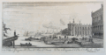 | Details | Sylvester, Israel | 1663 |
| Veduta e prospectiva della Piazza di St. Marco di Venezia |
|
Sylvester, Israel |
|
| 1663 |
| LOC:7 |
| $325.00 | Sylvester--Israel | Veduta-e-prospectiva-della-Piazza-di-St--Marco-di-Venezia | Rare antique copperplate etching of St Mark's Square in Venice, Italy, an oblique view from the Northeast looking down the Grand Canal with the lagoon to the left. At right are the Doge's palace and Biblioteca Marciana with Punta della Dogana and the entrance to the Grand Canal in the background. Shows numerous small vessels underway and moored; at far left the decoratively carved stern of a sailing vessel with banners fluttering in the breeze.
<BR> </BR>
Engraved and drawn by artist Israel Sylvestre (1621-1691). Published by Pierre Mariette (1634-1716) "avec privilege du Roy" in Paris. The print was likely published after 1663 when Sylvestre was appointed court painter and engraver by Louis XIV and would have been able to claim royal privilege. Title also in French at bottom of engraving. Number 11. |
| 887 | 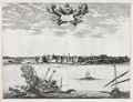 | Details | Dapper, Olfert (Olivier) | 1668 |
| Antique view of a battle among galleys off Tripoli, Libya |
|
Dapper, Olfert (Olivier) |
|
| 1668 |
| LOC:1 |
| $340.00 | Dapper--Olfert-(Olivier) | Antique-view-of-a-battle-among-galleys-off-Tripoli--Libya | Interesting antique elevation view of <b>Tripoli, Libya</b> by Olfert Dapper (1636 - 1689). Oared galleys battle in the foreground with at least one galley shown in flames and apparently sinking. Strong copperplate impression and a visible platemark close to the neatline support the early date of this engraved panoramic view.
<br></br>
From the original Dutch version of Olfert Dapper's <b>"Description of Africa"</b> or "Naukeurige beschrijvinge der Afrikaensche gewesten van Egypten, Barbaryen, Libyen, Biledulgerid, Negroslant, Guinea, Ethiopiën, Abyssinie ..." Dapper was a Dutch writer and self-described physician best known for his books on Africa, China, Persia and Arabia.
<br></br>
Published by Jacob van Meurs from Amsterdam in 1668. Other later editions of Dapper's view of Tripoli exist with French and German text but those copies include an additional title in the language of publication. This example has a single title in Dutch. This plate corresponds to an example found in the Dutch version held in the collection of the Getty Research Institute. <a href="https://archive.org/details/gri_33125009359999 " target="_blank"> Internet. </a>
<br></br>
Page 437. Verso is blank. |
| 4842 |  | Details | Hollar, Wenceslaus | 1676 |
| Rare view of Plymouth, England with the Catwater |
|
Hollar, Wenceslaus |
|
| 1676 |
| LOC:13 |
| $250.00 | Hollar--Wenceslaus | Rare-view-of-Plymouth--England-with-the-Catwater | Rare, small view of Plymouth, England with the Catwater from 1676 by Czech etcher Wenceslaus Hollar (1607-1677). From a series by Hollar titled "Divers Views after the Life." No record of any sale in AMPR; none online for sale. Signed within as "W. Hollar fecit 1676".
<br></br>
Hollar published his first book of etchings in 1635 in Cologne when Hollar was twenty-eight. Hollar was in London during the Great Fire of 1666, and remains most famous for his scenes of the city before and after the fire. |
| 4742 | 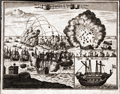 | Details | Anonymous | 1680 |
| Antique engraving of the bombardment of St. Malo France |
|
Anonymous |
|
| 1680 |
| LOC:77 |
| $150.00 | Anonymous | Antique-engraving-of-the-bombardment-of-St--Malo-France | Anonymous antique engraved print of the bombardment of St. Malo, France, probably during the 17th century. Decorative unusual copper engraved map ca. 1680 showing a naval siege of Saint-Malo, France. The plate show the city with its buildings, churches, harbor and town walls. Inset showing a warship "Das Machine Schiff" (probably a bomb vessel). Verso blank. |
| 914 | 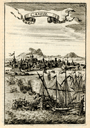 | Details | Mallet, Allain Manesson | 1683 |
| Candie |
|
Mallet, Allain Manesson |
|
| 1683 |
| LOC:2 |
| $85.00 | Mallet--Allain-Manesson | Candie | Small, attractive antique view of the harbor of Candia (Heraklion or Iraklio) on Crete, Greece with mosques and other buildings surmounted by the cresent moon of the Ottoman Caliphate. Galleys and other warships battle offshore in the Mediterranean Sea and the smoke of cannon fire indicate a westerly breeze. By Allain Mallet, Paris, 1683.
<br></br>
The Ottomans captured most of Crete during the early years of the Cretan War (1645-1669) but the Venetians retained control of the capital, Candia, until the very end in 1669. This engraved view probably captures a moment in the final battle for control of Heraklion. Page 203.
<br></br>
Published by Mallet in "Description de l'Univers" . Allain Mallet (1630-1706) was a French engineer, soldier, and cartographer. He served in the court of King Louis XIV as a techer of mathematics. In addition to "Description de l'Univers" Mallet also published "Les Travaux de Mars ou l'Art de la Guerre". |
| 918 |  | Details | Mallet, Allain Manesson | 1683 |
| Antique print of the terrestrial globe |
|
Mallet, Allain Manesson |
|
| 1683 |
| LOC:1 |
| $55.00 | Mallet--Allain-Manesson | Antique-print-of-the-terrestrial-globe | Charming antique print of a castle with hundreds of mounted soldiers streaming out towards nearby ships. Set into that background is a view of the globe including the North and South American continents with Europe and Africa. By Allain Mallet, Paris, 1683.
<br></br>
Published by Mallet in "Description de l'Univers". Allain Mallet (1630-1706) was a French engineer, soldier, and cartographer. He served in the court of King Louis XIV as a techer of mathematics. In addition to "Description de l'Univers" Mallet also published "Les Travaux de Mars ou l'Art de la Guerre". |
| 621 | 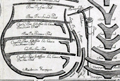 | Details | Arnaves, J. | 1683 |
| Naval Architecture- Pieces of an First Rate French Warship circa 1683 |
|
Arnaves, J. |
|
| 1683 |
| LOC:55 |
| $2,600.00 | Arnaves--J- | Naval-Architecture--Pieces-of-an-First-Rate-French-Warship-circa-1683 | Highly interesting and very rare graphical parts diagram of all the pieces used in the construction of a French first-rate ship-of-the line, including structural members. This is an antique original copperplate engraved print dated within to 1683. Attribution at bottom left is to the creator "J. Arnave fec(it)" but the original inspiration for the work is attributed within an inset to Francois Coullomb: "Faict a Toulon dans lescolle de la construction par Francois Coullomb Fitz avec permission 1683." <br></br>
The original usage of the diagram by Coullomb was as a large wall chart for students at the royal shipyard at Toulon, France. Includes ( in French ) the name, count, and size of each piece. The pieces shown include frames, longitudinals, knees, bitts, grates, masts, capstans, ladders, cannon, anchors, rudder, and numerous decorative trim. <br></br>
This work was probably bound into a copy of Henri Sbonski de Passebon's "Plan de Plusieurs Batiments de Mer avec leurs Proportions" a volume of engravings dedicated to late 17th century nautical architecture. <br></br>
Published from Toulon, France, the home to the regular French naval forces ( Vaisseaux ). |
| 1366 | 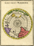 | Details | Mallet, Allain Manesson | 1683 |
| Antique Southern Polar Map of the World |
|
Mallet, Allain Manesson |
|
| 1683 |
| LOC:0 |
| $90.00 | Mallet--Allain-Manesson | Antique-Southern-Polar-Map-of-the-World | Small, hand-colored antique view of the globe from a south polar perspective. Shows the lower portions of Africa and South America. Incomplete and naïve representation of Australia, Tasmania, and New Zealand reflect that in the late 17th century knowledge of the geography of those areas was still incomplete. By Allain Mallet, Paris, 1683.
<br></br>
Published by Mallet in "Description de l'Univers" . Allain Mallet (1630-1706) was a French engineer, soldier, and cartographer. He served in the court of King Louis XIV as a teacher of mathematics. In addition to "Description de l'Univers" Mallet also published "Les Travaux de Mars ou l'Art de la Guerre". |
| 324 |  | Details | Wagner, Johann Christoph | 1684 |
| Untitled - Kriegsschiff |
|
Wagner, Johann Christoph |
|
| 1684 |
| LOC:0 |
| $400.00 | Wagner--Johann-Christoph | Untitled---Kriegsschiff | Antique print of a decorative 3 masted sailing vessel firing stern cannon. This early wood-block print shows a early 17th century vessel of war. Interesting feature of this time period are the six crows nests. These would have been used in battle to hurl stones, javelins and even caustic substances down on the heads of the opposition forces. An opportunity to own a plate that was first published in Furttenbach's very scarce 1629 classic of naval architecture "Architectura Navalis" . Interesting rigging! <BR> </BR>
Note: Seller has attributed the source as Wagner's "Delineatio Provinciarum Pannoniae et Imperii Turcici in Oriente Eine Grundrichtige Beschreibung deß ganzen Aufgangs", published in Augsburg 1684. "N3" at upper left. |
| 314 | 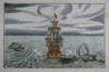 | Details | Wagner, Johann Christoph | 1684 |
| Untitled - Ship firing on attacking sea serpents |
|
Wagner, Johann Christoph |
|
| 1684 |
| LOC:0 |
| $800.00 | Wagner--Johann-Christoph | Untitled---Ship-firing-on-attacking-sea-serpents | Highly decorative, whimsical, rare antique wood-block nautical engraving of a sailing ship firing at sea monsters on both sides of the vessel. Ship bears an ensign of a forearm bearing a sword. A great chance to have a plate that was first published in Furtenbach's very scarce 1629 classic of naval architecture "Architectura Navalis" . <BR> </BR>
Note: Seller has attributed the source as Wagner's "Delineatio Provinciarum Pannoniae et Imperii Turciciin Oriente Eine Grundrichtige Beschreibung deß ganzen Aufgangs", published in Augsburg 1684. "N4" at upper left. |
| 5105 | 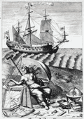 | Details | Blome, Richard | 1685 |
| Original Navigation Engraving by Richard Blome |
|
Blome, Richard |
|
| 1685 |
| LOC:88 |
| $300.00 | Blome--Richard | Original-Navigation-Engraving-by-Richard-Blome | Fine original copper-plate engraving "Navigation" from Gentleman's Recreation by Richard Blome. This plate, as many others in Blome's encyclopedia, was dedicated to an English nobleman. Show's a 17th century square-rigged sailing vessel with charts, a globe, compass and other navigation instruments.
<br></br>
Dedicated to George Legge, Baron of Dartmouth, Master General of the Ordnance and many other titles.
<br></br>
From Blome's "The Gentleman's Recreation. ... An Encyclopedy of the Arts and Sciences ... Horsemanship, Hawking, Hunting, Fowling, Fishing and Agriculture. With a Short Treatise of Cock-Fighting." |
| 898 |  | Details | Peeters, Jan | 1685 |
| Scarce panoramic view of Iraklio on the Greek island of Crete |
|
Peeters, Jan |
|
| 1685 |
| LOC:2 |
| $180.00 | Peeters--Jan | Scarce-panoramic-view-of-Iraklio-on-the-Greek-island-of-Crete | This fine antique etching is a panoramic profile view of the city of <b>Iraklio ("Candia")</b> on the island of Crete, Greece. With a backdrop of the fortified town of Iraklio and a harbor full of square-rigged ship's masts the view shows two galleys (presumed Venetian) departing the harbor and heading out to sea.
<br></br>
At the time this etching was published Venice was at war with the Ottoman Empire. Venice had been in control of Crete until 1669 when the Ottomans overran the island but failed to capture Iraklio. Venice managed to hang on to Iraklio until 1715.
<br></br>
Published by Jacob Peeters in Antwerp, ca 1685. Based on a drawing by the brother of Jacob Peeters- Jan (Johannes) Peeters. The etching originates from Peeter's rare edition of: 'Korte beschryvinghe, ende aenwysinghe der plaetsen in desen boeck, naar hunnen tegenwoordighen standt, pertinentelyck uyt-ghebeeldt, in Oostenryck", a collection of prints relating to the <b>Great Turkish war (1667-1683)</b>. |
| 5240 |  | Details | Coronelli, Vincenzo | 1689 |
| Primi Elementi o Introdutione al Corso Geografico |
|
Coronelli, Vincenzo |
|
| 1689 |
| LOC:62 |
| $650.00 | Coronelli--Vincenzo | Primi-Elementi-o-Introdutione-al-Corso-Geografico | An attractive, fine original copper-plate engraving that illustrates the basic principles of geography. The main map is a double hemisphere without landmasses, showing lines of latitude and longitude and climate zones The left sphere is inscribed with the names of the compass points and directions. The right sphere is inscribed with the names of the winds, and the is sphere divided into climatic zones.
<br></br>
The spheres are surrounded by several smaller spherical diagrams and tables making in all a very interesting and informative graphic compilation of the state of geographical knowledge in Venice, Italy at the end of the 17th century. From Coronelli's Atlante Veneto, based on work derived from his large globes.
<br></br>
Vincenzo Maria Coronelli (1650-1718) is considered as one of Italy's most famous and greatest cartographers. Coronelli was an Italian Franciscan friar, cartographer, cosmographer and encyclopedist, a trained wood engraver who studied astronomy, Euclidean geometry and ancient philosophy and was named cosmographer for the Republic of Venice.
<br></br>
Coronelli became most famous for his very large globes built in Paris from 1681-1683 at the order of King Louis XIV. His terrestrial and celestial globes measured 3.9 meters in diameter and were not equaled for more than 200 years. |
| 4942 | 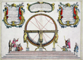 | Details | Coronelli, Vincenzo | 1689 |
| Globe Celeste |
|
Coronelli, Vincenzo |
|
| 1689 |
| LOC:62 |
| $650.00 | Coronelli--Vincenzo | Globe-Celeste | A copper-plate engraved view of the Globe Celeste of Vincenzo Maria Coronelli (1650-1718), considered as one of Italy's most famous and greatest cartographers. Coronelli was an Italian Franciscan friar, cartographer, cosmographer and encyclopedist, a trained wood engraver who studied astronomy, Euclidean geometry and ancient philosophy and was named cosmographer for the Republic of Venice.
<br></br>
Coronelli became most famous for his very large globes built in Paris from 1681-1683 at the order of King Louis XIV. His terrestrial and celestial globes measured 3.9 meters in diameter and were not equaled for more than 200 years.
<br></br>
The print, dated within at 1689, celebrates the consecration of the Celestial Globe in 1683 by Cardinal Destrees. Scarce. Only two sales recorded in the AMPR. |
| 305 | 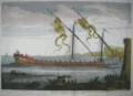 | Details | Henri Sbonski de Passebon | 1690 |
| La galere Patronne a la rame |
|
Henri Sbonski de Passebon |
|
| 1690 |
| LOC:50 |
| $1,100.00 | Henri-Sbonski-de-Passebon | La-galere-Patronne-a-la-rame | "La galere (galère, Fr.) patronne a la rame" is one of a series of 17 antique folio-sized copperplate engravings created ca. 1690 by French galley Captain Henry Sbonski de Passebon. This print was engraved by Claude Randon, as part of a volume of nautical architecture plates first published from Marseille where, in the late 17th century the arsenal was home port to the galley service of Louis XIV.<BR> </BR>
<a style="color:#9BAFCB" rel="nofollow" href= "/SbonskiPassebonBackground.aspx">View other
Sbonski de Passebon engravings</a>
<BR> </BR>
De Passebon was stationed at Marseilles as a Lieutenant in the Corps des Galeres during the period that he produced the drawing from which this antique print was engraved. Therefore this plate, drawn from first-hand observation, is perhaps the best record of the Patronne available. There was only one Patronne in the Galley Corps, typically reserved for the Lieutenant General des Galeres and the Patronne was second in prominence and beauty only to the royal galley, the Reale.<BR> </BR>
<br>Attribution at bottom left: "Randon delineauit et sculpsit cura D'ni de Passebon Equitis"
<br>Royal privilege at bottom right: "Marsiliae cum privilegio Regis"
<br>Seller's attribution: "Se vendent a Marseilles chez Laurent Bremond sur le port au Coin de reboul" |
| 306 | 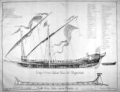 | Details | Henri Sbonski de Passebon | 1690 |
| Coupe d'une galere avec ses proportions |
|
Henri Sbonski de Passebon |
|
| 1690 |
| LOC:50 |
| $1,400.00 | Henri-Sbonski-de-Passebon | Coupe-d-une-galere-avec-ses-proportions | "Coupe d'une galere avec ses proportions" is one of a series of 17 antique folio-sized copperplate engravings created ca. 1690 by <strong>French galley Captain Henry Sbonski de Passebon.</strong> Scarce cutaway print of a standard late <strong>17th century French galley</strong> (galère, Fr.) with a detailed legend of parts (in French). Below the galley is a representation of the keel-form at the shipyard on which the keel was apparently built up. Very scarce.
<BR> </BR>
<a style="color:#9BAFCB" rel="nofollow" href= "/SbonskiPassebonBackground.aspx">View all Sbonski de Passebon engravings</a>
<BR> </BR>
Engraved by Barthelemy Chasse, the collection of nautical architecture plates was first published from Marseille where, in the late 17th century the arsenal was home port to the galley service of Louis XIV. This is the only plate in the volume engraved by Chasse. All other plates were engraved by Claude Randon.
<BR> </BR>
De Passebon was stationed at Marseilles as a Lieutenant in the Corps des Galeres during the period that he produced the drawings from which these plates were engraved.
<BR> </BR>
Attribution at bottom left: "Randon delineauit et sculpsit cura D'ni de Passebon Equitis"
<BR></BR>Royal privilege at bottom right: "Marsiliae cum privilegio Regis"
<BR></BR>Seller's attribution: <strong>"Se vendent a Marseilles chez Laurent Bremond sur le port au Coin de reboul"</strong> (Sold by Laurent Bremond from the port [Marseille] at the corner of Reboul [street].) |
| 308 | 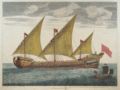 | Details | Henri Sbonski de Passebon | 1690 |
| Galeasse a la voile |
|
Henri Sbonski de Passebon |
|
| 1690 |
| LOC:0 |
| $5,000.00 | Henri-Sbonski-de-Passebon | Galeasse-a-la-voile | Antique engraved print titled "Galeasse a la voile" depicts a Venetian galeazza (galeasse) under full sail. We know the vessel is from Venice, Italy because under close inspection one can see the faint outline of the Lion of St. Marks on the flag at the very top of the main mast. A galeasse is a larger vessel than a galley (galère, Fr.) typically powered by 3 lateen-rigged sails as well as oars. <BR> </BR>
This highly detailed plate is one of a series of 17 folio-sized antique copperplate engravings created ca. 1690 by French galley Captain Henry Sbonski de Passebon. Engraved by Claude Randon, the volume of nautical architecture plates was first published from Marseille where, in the late 17th century the arsenal was home port to the galley service of Louis XIV.<BR> </BR>
<a style="color:#9BAFCB" rel="nofollow" href= "/SbonskiPassebonBackground.aspx">View all Sbonski de Passebon engravings</a>
<BR> </BR>
De Passebon was stationed at Marseilles as a Lieutenant in the Corps des Galeres during the period that he produced the drawings from which these plates were engraved. <BR> </BR>
<br>Attribution at bottom left: "Randon delineauit et sculpsit cura D'ni de Passebon Equitis"
<br>Royal privilege at bottom right: "Marsiliae cum privilegio Regis"
<br>Seller's attribution: "Se vendent a Marseilles chez Laurent Bremond sur le port au Coin de reboul" |
| 309 | 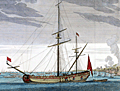 | Details | Henri Sbonski de Passebon | 1690 |
| Galiote a bombe |
|
Henri Sbonski de Passebon |
|
| 1690 |
| LOC:0 |
| $2,400.00 | Henri-Sbonski-de-Passebon | Galiote-a-bombe | 'Galiote a bombe' or 'bomb galiote' is an antique folio-sized copperplate engraving created ca. 1690 by French galley Captain Henry Sbonski de Passebon. This original antique engraving is the earliest readily available rendering of a bomb vessel. No doubt de Passebon was intimately familiar with this type ship- he is reported to have participated in the French bombardment of Genoa in 1684. Engraved by Claude Randon, this example is one of 17 ship engravings in a collection of nautical architecture plates first published from Marseille where, in the late 17th century the arsenal was home port to the galley service of Louis XIV. <BR> </BR>
A 'Bomb Vessel' or 'Bomb Ketch' was typically 60 to 70 feet long and drew 8 or 9 feet of water. This relatively shallow draft would have enabled the vessels to approach closer to their target, One authoritative source defines 'Bomb Vessel' : as <div class="indenttextblock">"a ship of the old sailing navies armed with one or occasionally two, heavy howitzers or mortars and used for bombarding places ashore. Mostly the mortars were fitted in ketches either specially built or converted into such from a small three-masted vessel by the removal of her foremast to provide a good deck space forward for the mortars. When employed in bombardment, bomb vessels were moored in position with springs on their cables so that the ships themselves were trained for the mortars to fire on the desired bearing."(Oxford Companion to Ships and The Sea, Peter Kemp, ed. Oxford University Press. London, 1976, p. 93.)</div>In this example it can be seen clearly that the foremast had been removed as described above.<br></br>
De Passebon was stationed at Marseilles as a Lieutenant in the Corps des Galeres during the period that he produced the drawings from which these plates were engraved. |
| 310 | 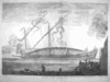 | Details | Henri Sbonski de Passebon | 1690 |
| La galere reale a la fonde |
|
Henri Sbonski de Passebon |
|
| 1690 |
| LOC:0 |
| $1,400.00 | Henri-Sbonski-de-Passebon | La-galere-reale-a-la-fonde | "La galere reale a la fonde" is one of a series of 17 folio-sized antique copperplate engravings created ca. 1690 by French galley Captain Henry Sbonski de Passebon. Engraved by Claude Randon, the collection of nautical architecture plates was first published from Marseille where, in the late 17th century the arsenal was home port to the galley (galère, Fr.) service of Louis XIV.<BR> </BR>
<a style="color:#9BAFCB" rel="nofollow" href= "/SbonskiPassebonBackground.aspx">View all Sbonski de Passebon engravings</a>
<BR> </BR>
De Passebon was stationed at Marseilles as a Lieutenant in the Corps des Galeres during the period that he produced the drawings from which these plates were engraved. <BR> </BR>
<br>Attribution at bottom left: "Randon delineauit et sculpsit cura D'ni de Passebon Equitis"
<br>Royal privilege at bottom right: "Marsiliae cum privilegio Regis"
<br>Seller's attribution: "Se vendent a Marseilles chez Laurent Bremond sur le port au Coin de reboul" |
| 311 | 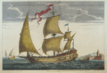 | Details | Henri Sbonski de Passebon | 1690 |
| Polacre a la voille |
|
Henri Sbonski de Passebon |
|
| 1690 |
| LOC:50 |
| $2,500.00 | Henri-Sbonski-de-Passebon | Polacre-a-la-voille | "Polacre a la voille" is one of a series of 17 folio-sized antique copperplate engravings created ca. 1690 by French galley Captain Henry Sbonski de Passebon. Engraved by Claude Randon, the collection of nautical architecture plates was first published from Marseille where, in the late 17th century the arsenal was home port to the galley service of Louis XIV.<BR> </BR>
<a style="color:#9BAFCB" rel="nofollow" href= "/SbonskiPassebonBackground.aspx">View all Sbonski de Passebon engravings</a><BR> </BR>
De Passebon was stationed at Marseilles as a Lieutenant in the Corps des Galeres during the period that he produced the drawings from which these plates were engraved. <BR> </BR>
<br>Attribution at bottom left: "Randon delineauit et sculpsit cura D'ni de Passebon Equitis"
<br>Royal privilege at bottom right: "Marsiliae cum privilegio Regis"
<br>Seller's attribution: "Se vendent a Marseilles chez Laurent Bremond sur le port au Coin de reboul" |
| 312 | 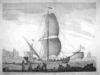 | Details | Henri Sbonski de Passebon | 1690 |
| Saique batiment dont les Turcs |
|
Henri Sbonski de Passebon |
|
| 1690 |
| LOC: |
| $1,600.00 | Henri-Sbonski-de-Passebon | Saique-batiment-dont-les-Turcs | "Saique batiment dont les Turcs" is one of a series of 17 folio-sized antique copperplate engravings created ca. 1690 by French galley Captain Henry Sbonski de Passebon. Engraved by Claude Randon, the collection of antique nautical architecture plates was first published from Marseille where, in the late 17th century the arsenal was home port to the galley service of Louis XIV.<BR> </BR>
According to Wikipedia- "A <a rel="nofollow" href= "http://en.wikipedia.org/wiki/Ca%C3%AFque">caïque</a> (Greek: καΐκι, kaiki, from Turkish: kayık ) is the term for a traditional fishing boat usually found among the waters of the Ionian or Aegean Sea, and also a light skiff used on the Bosporus."
<BR> </BR>
<a rel="nofollow" href= "/SbonskiPassebonBackground.aspx">View all Sbonski de Passebon engravings</a>
<BR> </BR>
De Passebon was stationed at Marseilles as a Lieutenant in the Corps des Galeres during the period that he produced the drawings from which these plates were engraved. <BR> </BR>
<br>Attribution at bottom left: "Randon delineauit et sculpsit cura D'ni de Passebon Equitis"
<br>Royal privilege at bottom right: "Marsiliae cum privilegio Regis"
<br>Seller's attribution: "Se vendent a Marseilles chez Laurent Bremond sur le port au Coin de reboul" |
| 313 | 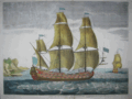 | Details | Henri Sbonski de Passebon | 1690 |
| Vaisseau du troiseme rang a la voille |
|
Henri Sbonski de Passebon |
|
| 1690 |
| LOC:0 |
| $4,950.00 | Henri-Sbonski-de-Passebon | Vaisseau-du-troiseme-rang-a-la-voille | "Vaisseau du troiseme rang a la voille" is one of a series of 17 folio-sized antique copperplate engravings created ca. 1690 by French galley Captain Henry Sbonski de Passebon. Engraved by Claude Randon, the collection of nautical architecture plates was first published from Marseille where, in the late 17th century the arsenal was home port to the galley service of Louis XIV.<BR> </BR>
<a style="color:#9BAFCB" rel="nofollow" href= "/SbonskiPassebonBackground.aspx">View other Sbonski de Passebon engravings</a>
<BR> </BR>
De Passebon was stationed at Marseilles as a Lieutenant in the Corps des Galeres during the period that he produced the drawings from which these plates were engraved. <BR> </BR>
<br>Attribution at bottom left: "Randon delineauit et sculpsit cura D'ni de Passebon Equitis"
<br>Royal privilege at bottom right: "Marsiliae cum privilegio Regis"
<br>Seller's attribution: "Se vendent a Marseilles chez Laurent Bremond sur le port au Coin de reboul" |
| 321 |  | Details | Henri Sbonski de Passebon | 1690 |
| Galere a la voille portant l'Estendart de chef d'Escadre |
|
Henri Sbonski de Passebon |
|
| 1690 |
| LOC:50 |
| $2,275.00 | Henri-Sbonski-de-Passebon | Galere-a-la-voille-portant-l-Estendart-de-chef-d-Escadre | This rare and decorative antique copper-plate engraving depicts an ordinary French galley (galère, Fr.) under sail in the Mediterranean, the cookstove billowing white smoke slightly aft of midships on the port side.<BR> </BR>
"Galere a la voille portant l'Estendart de chef d'Escadre" (Galley under sail with the banner of the squadron leader) is one of a series of 17 folio-sized copperplate engravings created ca. 1690 by French galley Captain Henry Sbonski de Passebon. Engraved by Claude Randon, the collection of nautical architecture plates ("Plan de Plusieurs Batiments de Mer et ses proportions") was first published from Marseille where, in the late 17th century the arsenal was home port to the galley service of Louis XIV.<BR> </BR>
<a style="color:#9BAFCB" rel="nofollow" href= "/SbonskiPassebonBackground.aspx">View other Sbonski de Passebon engravings</a> <BR> </BR>
Sbonski de Passebon was stationed at Marseilles as a Lieutenant in the Corps des Galeres during the period that he produced the drawings from which these antique plates were engraved. His close affiliation with the galley corps resulted in highly detailed renderings that capture the technical flavor of early 18th century seafaring along with the beauty of the nearby Mediterranean shoreline. Within 50 years of the publication of these plates the French Corps des Galeres was disbanded as the galley was no longer a cost-effective means of projecting power.<BR> </BR>
Attribution at bottom left: "Randon delineauit et sculpsit cura D'ni de Passebon Equitis"
<BR> </BR> Royal privilege at bottom right: "Marsiliae cum privilegio Regis"
<BR> </BR> Seller's attribution: "Se vendent a Marseilles chez Laurent Bremond sur le port au Coin de reboul"
<BR> </BR> This plate has been professionally restored, neutralized, and colored and contains wider margins that those shown.<BR> </BR> |
| 619 | 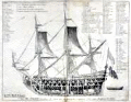 | Details | Henri Sbonski de Passebon | 1690 |
| Antique 17th Century Cutaway View of French Admiral's Flagship |
|
Henri Sbonski de Passebon |
|
| 1690 |
| LOC:55 |
| $750.00 | Henri-Sbonski-de-Passebon | Antique-17th-Century-Cutaway-View-of-French-Admiral-s-Flagship | Antique and scarce 1690 cutaway architectural view of a French Admiral's flagship of 104 cannons. Bernard Quaritch's Catalog No. 229. <sup>1 </sup> attributes the engraving's design to French galley Captain Henri Sbonski de Passebon and the engraving to Claude Randon in de Passebon's "Plans de Plusieurs Batiments de Mer avec leurs Proportions". <br></br>
This highly detailed plate is one of 17 folio-sized antique copperplate engravings in that work which included a similar cutaway of a oared galley. Engraved by Claude Randon, the volume of nautical architecture plates was first published from Marseille where, in the late 17th century the arsenal was home port to the galley service of Louis XIV.<br></br>
<sup>1 </sup> Quaritch, Bernard. "Catalogue of Works on the Fine Arts offered at the net prices affixed, By Bernard Quaritch." London, 1904. http://books.google.com/books?id=i0tFAAAAYAAJ&dq. |
| 1043 |  | Details | de Fer, Nicolas | 1690 |
| Title Page for Les Costes de France |
|
de Fer, Nicolas |
|
| 1690 |
| LOC:1 |
| $120.00 | de-Fer--Nicolas | Title-Page-for-Les-Costes-de-France | Very cool and interesting title page with a depiction of numerous late 17th century maritime activities attending harbor work.
<br></br>
This title page was produced by the well known French geographer and cartographer, Nicolas de Fer (1646 - 1720). De Fer was a prolific producer of maps and prints who among other honors, was appointed as official geographer to the Spanish King in 1702. Published in de Fer's atlas: "Les Costes de France sur l'Océan et la Mer Mediterranee..." with 32 engraved charts. That work was a re-issue of Christophe Tassin's 1634 work "Cartes Generale et Particulieres de toutes le costes de France tant de la mer Oceane que Mediterranee". |
| 1150 |  | Details | Narbrough, John | 1694 |
| Early 17th century engraved whaling scene |
|
Narbrough, John |
|
| 1694 |
| LOC:1 |
| $300.00 | Narbrough--John | Early-17th-century-engraved-whaling-scene | Early foldout engraved bookplate (1697) depicting a whaling scene to illustrate Friedrich Martens' observations on northern whaling. Attractive antique print shows multiple whaling ships and ships boats engaged in harpooning, fighting, and flensing whales. A fine gift.
<br></br>
The view lends insight into the methods used to hunt whales in the early 17th century in the whaling grounds of the far northern latitudes like Greenland and the island of Spitsbergen, Norway. For example the ship at far right is shown tied off to an iceberg, a practice noted by Narbrough in the text. <div class="indenttextblock"> "When they sail some Miles into the Ice, where there is pretty large Ice-fields, they joyn their Ships to them with great Ice-hooks, fastned to strong Cables, where they lie at Anchor, several Ships about the same Ice-field, but they rather chose to be alone, because they are an hindrance to one another in Whale catching, and the hunting of them from one to another maketh them shie. (Online: http://darwin-online.org.uk/converted/Ancillary/BeagleLibrary/1694_Narborough_A813.html")</div>
</br>
Originally published in 1694 to accompany "The First Part of the Voyage into Spitsbergen and Greenland.", this record of recent voyages made by Sir John Narborough, Abel Tasman, John Wood and Friderich Martens. Narborough's journal records his voyage to the Straits of Magellan and his interest in the lands and peoples he encountered from 1669 to 1671.
<br></br>
This fine antique print illuminates Friedrich Martens' (1635 - 1699) observations on Spitsbergen and whaling in northern waters in 1671. |
| 4710 |  | Details | Chatelain, Henry | 1695 |
| Carte Generalle du Gouvernement Militaire de France |
|
Chatelain, Henry |
|
| 1695 |
| LOC:0 |
| $250.00 | Chatelain--Henry | Carte-Generalle-du-Gouvernement-Militaire-de-France | Folio-size antique copperplate engraving on chain-laid paper by Chatelain. This scarce decorative historical artifact records the state of France's land and naval forces in 1695.
<BR> </BR>
Contains detailed textual information on the finances and disposition of France's military not found elsewhere and a wealth of images related to those sea forces. It includes views of major naval ports, weapons, emblems, and flags associated with both the regular navy and the galley corps.
<BR> </BR>
There was considerable inter-service rivalry between the sailing navy (vaisseaux) and the galley corps (galeres) of which there were then 40 vessels. The lower left quadrant contains a breakdown by type of the total 665 vaisseaux then in service. The lower right quadrant is dedicated solely to the galley corps, which was then near the peak of its power, listing the number of officers of each rank and the count of each galley type- for instance 1 Galere Reale (Royal Galley, the premier vessel). From the information provided by Chatelain we learn that 6 galleys would have been stationed outside the Mediterranean or Levant: 2 each in Bordeaux, St Malo, and Dunkirk.
<BR> </BR>
Less than 30 years after this engraving was published the Corps des Galeres was disbanded (1748), not able to compete against larger, better armed ships of the line. This sheet provides detailed historical background for collectors of <a rel="nofollow" href= "/MichelotBremondBackground.aspx">Michelot and Bremond</a> charts which were created during the period represented by this plate. Plate 28. |
| 920 |  | Details | Vianen, Jan van | 1698 |
| Title Page from Claudii Ptolemaei Tabulae Geographicae… |
|
Vianen, Jan van |
|
| 1698 |
| LOC:0 |
| $250.00 | Vianen--Jan-van | Title-Page-from-Claudii-Ptolemaei-Tabulae-Geographicae… | Antique engraved print. Beautiful copperplate engraved title page from Claudii Ptolemaei Tabulae Geographicae Orbis Terrarum Veteribus Cogniti, engraved by Jan van Vianen. Published by François Halma & Willem van den Water, Utrecht & Leonard Strick, Franeker, in 1698. |
| 393 | 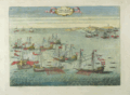 | Details | Fontana, Fulvio | 1701 |
| Presa di Due Galee Turchesche |
|
Fontana, Fulvio |
|
| 1701 |
| LOC:50 |
| $375.00 | Fontana--Fulvio | Presa-di-Due-Galee-Turchesche | Scarce copperplate engraving depicts a battle between Ottoman galleys and galleys from the military order of Saint Stephen (Santo Stefano) Pope and Martyr. Location of that engagement was near the Strait of Bonifacio (Bocche de Bonifazio), between Corsica and Sardegna. The order of Santo Stefano was founded by Cosimo I de' Medici in 1561. The purpose of the order , with financial support from the Grand Dukes of Tuscany, was to free Christians from slavery by fighting Ottomans and pirates. Vessels of the order of Santo Stefano are marked by flags with the symbol of their order, an eight-pointed cross much like that of the Knights of Malta.<BR> </BR>
From: "I pregi della Toscana nell' imprese piu segnalate de' Cavaliere di Santo Stefano opera dat a in luce da Fulvio Fontana della Compagnia di Gesu dedicata all' Altezza Reale di Cosimo III, Gran Duca di Toscana e Gran Maestro dell' Ordine. Published in 1701 from Florence by Mattia Miccioni and Michele Neftenus. Plate 2. Probably from a later state.<BR> </BR>
Reference: http://digital.ub.uni-duesseldorf.de/ihd/content/pageview/3361129 |
| 394 | 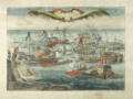 | Details | Fontana, Fulvio | 1701 |
| Presa di Cinque Legni Turcheschi |
|
Fontana, Fulvio |
|
| 1701 |
| LOC:50 |
| $375.00 | Fontana--Fulvio | Presa-di-Cinque-Legni-Turcheschi | Scarce copperplate engraving depicts a battle in 1596 conducted by galleys from the military order of Saint Stephen (Santo Stefano) Pope and Martyr and Muslim corsairs. The battle was led by Francesco Borbolani, eighth Admiral of the order of Santo Stefano. <BR> </BR>
The order of Santo Stefano was founded by Cosimo I de' Medici in 1561. The purpose of the order , with financial support from the Grand Dukes of Tuscany, was to free Christians from slavery by fighting Ottomans and pirates. Vessels of the order of Santo Stefano are marked by flags with the symbol of their order, an eight-pointed cross much like that of the Knights of Malta.<BR> </BR>
From "I pregi della Toscana nell' imprese piu segnalate de' Cavaliere di Santo Stefano opera dat a in luce da Fulvio Fontana della Compagnia di Gesu dedicata all' Altezza reale di Cosimo III, Gran Duca di Toscana e Gran Maestro dell' Ordine. Published in 1701 from Florence by Mattia Miccioni and Michele Neftenus. Plate 10. Probably from a later state of the engraving.<BR> </BR>
Reference: http://digital.ub.uni-duesseldorf.de/ihd/content/pageview/3361129 |
| 3615 | 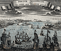 | Details | Bodenher, Gabriel | 1704 |
| Attractive antique birds-eye view of the Oresund with Kronborg Castle and Copenhagen |
|
Bodenher, Gabriel |
|
| 1704 |
| LOC:7 |
| $325.00 | Bodenher--Gabriel | Attractive-antique-birds-eye-view-of-the-Oresund-with-Kronborg-Castle-and-Copenhagen | Fine antique birds-eye view of the Oresund, the sound that separates Seeland (Denmark) from Schonen (Sweden). The copperplate-engraved view by Gabriel Bodenher is from the perspective of a viewer looking south into the north entrance of the Oresund. At the right are Helsingor, Kronborg Castle (Cronenburg), and Copenhagen. At left on the east side of the sound lie Helsingborg (Ellingburg), Landskrona (Lands Croon) and Malmo. Warships bearing flags of several nations are underway heading south in the direction of Copenhagen.
<br></br>
Gabriel Bodenehr (1673- 1765) was a German map maker and member of a famous family of Augsburg engravers and publishers. Bodenher is best known for his main work, Atlas Curieux, first published in 1704. |
| 868 | 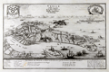 | Details | de Fer, Nicolas | 1705 |
| Antique Engraved Birds-eye View of Venice, Italy |
|
de Fer, Nicolas |
|
| 1705 |
| LOC:7 |
| $500.00 | de-Fer--Nicolas | Antique-Engraved-Birds-eye-View-of-Venice--Italy | Antique birds-eye view of Venice, Italy with the Grand Canal, Giudecca, the Venetian Arsenal, and St. Mark's Square as they existed around 1700. This attractive, detailed, copper-plate engraved view includes the outlying islands of Murano, Mazzorbo, Torcello, San Michelle, and others. Numerous churches are identifed by name and a legend at bottom is keyed to the six chief Venetian neighborhoods or sestieri. Ten important locations are identified including the columns at St. Mark's square, erected in the 13th century; two prisons; the Ducal Palace; and the customs house.
<br></br>
This antique view was produced by the well known French geographer and cartographer, Nicolas de Fer (1646 - 1720). De Fer was a prolific producer of maps and prints who among other honors, was appointed as official geographer to the Spanish King in 1702. Published in de Fer's atlas: "L'atlas curieux, ou Le monde réprésenté dans des cartes générales et particulières du ciel et de la terre… et orné par des plans et descriptions des villes capitales et principales, ...". |
| 867 | 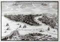 | Details | de Fer, Nicolas | 1705 |
| Birds-eye view of Constantinople or Istanbul, Turkey |
|
de Fer, Nicolas |
|
| 1705 |
| LOC:7 |
| $545.00 | de-Fer--Nicolas | Birds-eye-view-of-Constantinople-or-Istanbul--Turkey | Very detailed and attractive antique engraving of Constantinople or Istanbul,Turkey published from Paris in 1705. Minute detail of all the numerous towers, lighthouses, minarets and mosques that filled the city in the early 18th century.
<br></br>
Two settlements outside the well-fortifed walls are noted: Galata, and on the Anatolian side of the Bosphorous Strait- Scutari, which today is a municipality of Istanbul called Üsküdar. A few hundred meters off the coast of Scutari, on a small rocky islet is pictured the "Tour de Leander" or Maiden's Tower (Turkish: Kız Kulesi) , which over many centuries has served as watchtower, quarrantine station, lighthouse, and defensive structure. Today the tower has been converted into a café and restaurant.
<br></br>
Other named features include the Tower of Belisarius ("Tour de Bellissaire"), le Serail, the Seven Towers ("Les 7 Tours"), le Solimanie, Constantine's Palace, les Magazines de Pera, and Calcedoine.
<br></br>
This antique view was produced by the well known French geographer and cartographer, Nicolas de Fer (1646 - 1720). De Fer was a prolific producer of maps and prints who among other honors, was appointed as official geographer to the Spanish King in 1702. From "L'atlas curieux, ou Le monde réprésenté dans des cartes générales et particulières du ciel et de la terre." |
| 938 |  | Details | Chatelain, Henry | 1720 |
| View of Table Bay and Cape Town South Africa |
|
Chatelain, Henry |
|
| 1720 |
| LOC:6 |
| $295.00 | Chatelain--Henry | View-of-Table-Bay-and-Cape-Town-South-Africa | Attractive antique copper-plate engraving of Table Bay and early <b>Cape Town, South Africa</b>, about 40 miles north of the Cape of Good Hope. This very decorative view shows the nascent town of Cape Town with the Dutch Fort in the background and numerous ships at anchor in the foreground. In the far distance are Table Mountain and Devil's Peak. Table Bay was an important stop for resupplying ships making the passage to and from Europe and the East Indies.
<br></br>
With a textual description, in French, of the environs including that of nearby gardens and a small guest house or "Pavillon" of the <b>Dutch East India Company</b> near the garden. It was in that small guest house that a French embassy to Siam including six Jesuit priests set up an observatory during their stay in 1685. At bottom of the text is a engraved depiction of the guest house and gardens at night with a clock and telescope deployed to make astronomical observations; the Dutch fort visible in the background.
<br></br>
By Henri Chatelain, published in his <b>"Atlas Historique"</b> between 1705 and 1720.
<br></br>
Total size of page is 8" x 15"; the upper engraving of Table Bay and Mountain is 8" x 6". Book 6. No 17. Page 74. |
| 303 |  | Details | Rigaud, Jacques | 1720 |
| Feste des Galeres dans le Port de Marseille |
|
Rigaud, Jacques |
|
| 1720 |
| LOC:1 |
| $750.00 | Rigaud--Jacques | Feste-des-Galeres-dans-le-Port-de-Marseille | Beautiful early 18th century antique copperplate engraving of the Feste des Galeres (Galère, Fr.) (Galley Festival) held annually in Marseilles, France which was the home port of the Galley Corps during the reign of Louis XIV and Louis XV. At the time this engraving was produced the Galley Corps was in decline but the pomp and grandeur continued. The print shows several dozen galleys, moored stern-first as is the custom in that area, firing a tribute from cannon. The work is full of minute details of the festivities on shore among the onlookers and participants.
<BR> </BR>
Jacques Rigaud (1680-1754) was a French draftsman, artist, and engraver who worked for a time at the Arsenal in Marseille, home to the galley fleet. His first known work is "The View from the Fortress of Toulon" published in 1707. Rigaud was in Marseille during the great plague of 1720 and is well known for his prints of that event as well as for his series of engravings of the royal houses of France. Plate 3. |
| 1137 |  | Details | Henri Sbonski de Passebon | 1720 |
| Rare title page from de Passebon's engravings of nautical architecture |
|
Henri Sbonski de Passebon |
|
| 1720 |
| LOC:9 |
| $1,850.00 | Henri-Sbonski-de-Passebon | Rare-title-page-from-de-Passebon-s-engravings-of-nautical-architecture | Stunningly beautiful hand-colored engraved title page from Henri Sbonski de Passebon's ca. 1720
<a href="
https://www.rarecharts.com/SbonskiPassebonBackground.aspx" target="_blank">atlas of Mediterranean naval architecture</a>.
<br></br>
Engraved by Simonneau, drawn by Berey. |
| 4832 |  | Details | Limiers, Henri Philipp de | 1721 |
| Fine etched view of Kronstadt and St. Petersburg, Russia |
|
Limiers, Henri Philipp de |
|
| 1721 |
| LOC:13 |
| $265.00 | Limiers--Henri-Philipp-de | Fine-etched-view-of-Kronstadt-and-St--Petersburg--Russia | Early original engraved view of fortifications of Kronstadt (Cronstadt), Russia which Peter the Great founded on Kotlin (Retusari) Island in winter 1704 during the Great Northern War. Kotlin Island separates Neva Bay from the rest of the Gulf of Finland.
<br></br>
Despite the frigid conditions Imperial Russian forces quickly erected fortifications on the island:
<div class="indenttextblocksingle">
Under the command of Governor-general … Menshikov, workers used thousands of frames made of oak logs filled with stones which were carried by horses across the frozen sea, and placed in cuttings made in the ice. Thus, several new small islands were created, and forts were erected on them, virtually closing access to Saint-Petersburg by sea. Only two narrow navigable channels remained, with forts guarding them. (Online: https://en.wikipedia.org/wiki/Kronstadt).
</div>
<br/>
A few of the major features on this antique view of St. Petersburg may be identified by letter:
<div class="indenttextblocksingle">
<ul style="list-style-type: circle;">
<li>A- St. Petersburg, Russia</li>
<li>C - Kotlin Island (Retusari)</li>
<li>D- Kronstadt Fortifications</li>
</ul>
</div>
From "Histoire de Suede sous le Regne de Charles XII" by Limiers. Published from Amsterdam by Jansons & Waesberge. Tome 4. Page 188.
<br></br>
This view predates Bodenher's later, derivative print "Prospect von S. Petersgurg und der Insul Retusari" by 14 years. |
| 1433 | 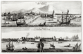 | Details | Aa, Pieter van der | 1725 |
| Scarce antique views of Batavia or Jakarta, Indonesia |
|
Aa, Pieter van der |
|
| 1725 |
| LOC:9 |
| $500.00 | Aa--Pieter-van-der | Scarce-antique-views-of-Batavia-or-Jakarta--Indonesia | Two fine antique copperplate-engraved views of Batavia (Jakarta, Indonesia), capital of the Dutch East Indies. One early view "La Ville de Batavie" with city structures in the background, shows the shallow channel to the inner harbor marked by pilings, with shallow-draft vessels plying the waters. Further off-shore deeper-draft, square-rigged sailing ships are drawn at anchor and tied to tall above-water structures we today would describe as pilings with cribbing. Excellent quality engravings.
<br></br>
The second view "Chateau de Batavia" presents a square-shaped fortress equipped with four protruding bastions made of solid earthen walls and coral with a strong wooden palisade. Batavia Castle was the administrative center of the Dutch East India Company (VOC) in Asia. Batavia Castle housed the administration buildings of the VOC, including the Governor-General's residence, residences for high officials, workshops, a treasury, a prison, storehouses and the meeting hall of the council of the Indies.
<br></br>
Batavia corresponds to the present city of Jakarta, Indonesia. Batavia was founded as the trade and administrative center of the Dutch East India Company and within Batavia's walls, the wealthy Dutch built tall houses and canals.
<br></br>
Published from Leiden by Pieter van der Aa.
<br></br>
Pieter van der Aa (1659 - 1733) was a Dutch publisher working in Leiden during the early eighteenth century. He is best known for publishing maps and atlases, though he also printed pirated editions of foreign bestsellers and illustrated volumes. From "La Galerie Agreable du Monde. Tome premier des Indes Orientales" published in 1725 from Leiden by Van der Aa. This plate was originally published in 'Gezandtschap der Nederlandtsche Oost-Indische Compagnie ...' by J. Nieuhof. |
| 50 |  | Details | Kip, Johannes | 1728 |
| Howland Great Dock near Deptford |
|
Kip, Johannes |
|
| 1728 |
| LOC:200 |
| $1,800.00 | Kip--Johannes | Howland-Great-Dock-near-Deptford | Very scarce and beautiful antique view of the Howland Great Dock (now Greenland Dock) surrounded by countryside. By the Dutch engraver Johannes Kip. Drawn by J.Badslade. This old nautical view has something to offer those interested in nautical history as well as those with an appreciation for esthetics.<BR> </BR>
Antique copperplate-engraved print was created within 20 years of the completion of the dock in 1695; the trees can be seen to not yet have fully matured. Cattle graze nearby and a horse-drawn coach makes its way presumably to London which is identified in the distance. More than 35 ships are shown moored within the wet dock, underway in the Thames or under construction in drydock. During the 18th century the dock was used greatly by Greenland whalers and the dock began to be called the "Greenland Dock". Numerous details of ship construction. |
| 1474 | 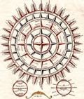 | Details | Aa, Pieter van der | 1729 |
| Philippi Brietii S.J. Ventorum Tabula |
|
Aa, Pieter van der |
|
| 1729 |
| LOC:200 |
| $180.00 | Aa--Pieter-van-der | Philippi-Brietii-S-J--Ventorum-Tabula | Decorative hand-colored engraving of a wind-rose. A wonderful piece that illustrates the ability of graphics to convey information about our earth.
<br></br>
The wind-rose is subdivided into five categories. First, "Divisio & Nomina Ventorum Apud Nautis" reads as "The winds divided and named according to navigators' .It uses an unusual and complicated wind rose to illustrate the directions and names of the best known winds around the world. Included are such names as 'Levante', 'Sirocco', 'Ponante', 'Transmontana' and 'Ostro vel Mezo Giorno'.
<br></br>
Antique engraving in Philip Cluver's magnum opus 'Introductionis in Universam Geographiam', a well-known geography textbook issued in various editions for many years beginning in 1624.
<br></br>
This very attractive engraving comes from a 1729 edition of 'Introductionis..' |
| 1004 | 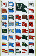 | Details | Diderot, Denis | 1730 |
| Marine Pavillons (Flags) Plate XX |
|
Diderot, Denis |
|
| 1730 |
| LOC:1 |
| $225.00 | Diderot--Denis | Marine-Pavillons-(Flags)-Plate-XX | Extremely decorative early 18th century hand-colored, engraved print depicting naval flags, pennants, and ensigns from across the world. Several flags contains the coat-of-arms of a royal family. Many flags contain a crescent moon, indicative of the Ottoman Empire. Plate 20. <BR> </BR>
Published by Diderot & D'Alembert in L'Encyclopédie. |
| 921 |  | Details | Sauzet, Henri du | 1734 |
| Title Page from Mercator's Atlas Minor |
|
Sauzet, Henri du |
|
| 1734 |
| LOC:1 |
| $100.00 | Sauzet--Henri-du | Title-Page-from-Mercator-s-Atlas-Minor | Antique engraved Dutch title page from Du Sauzet's Latin edition of Gerard Mercator's 'Atlas Minor'. Amsterdam. Dated within to 1734. Decorated with goddesses representing various geographical regions: Africa, Asia, Europa, Magalanica, Mexican, and Peruana, |
| 1430 |  | Details | Dufresnoy, Lenglet | 1736 |
| Terrestrial Armillary Sphere- A fine antique engraving. |
|
Dufresnoy, Lenglet |
|
| 1736 |
| LOC:0 |
| $90.00 | Dufresnoy--Lenglet | Terrestrial-Armillary-Sphere--A-fine-antique-engraving- | Very decorative copper-plate engraved print from 1736 containing an image of a terrestrial armillary sphere. An armillary sphere is a model of an astronomical object, including potentially the earth. They include graduated rings representing circles on a celestial sphere, such as the meridian, the poles, equator, ecliptic horizon, and the tropics.
<br></br>
Beneath the armillary sphere are three representations of the terrestrial globe as seen as both a whole sphere and divided into two hemispheres. In all, a very attractive and interesting antique enraving. Tome 1. Page 158.
<br></br>
From a work titled: "Methode pour Etudier la Geographie ou l'on donne une description exacte de l'Universe…" published by Rollin and de Bure, Quay des Augustins, du cote du Pont St. Michel. Published from Paris, France with the royal privilege in 1736. |
| 160 |  | Details | Pluche, N.A. | 1736 |
| A Galley on Her Oars |
|
Pluche, N.A. |
|
| 1736 |
| LOC:0 |
| $75.00 | Pluche--N-A- | A-Galley-on-Her-Oars | Small copperplate antique engraving by Pluche showing a galley (galère) with 27 oars per side with the sails furled as it heads into harbor. Large banners attached to the antennae drift in the breeze as several sailors work on the rigging in the forward part of the ship. Plate 15. Vol 3. Page 132. |
| 161 |  | Details | Pluche, N.A. | 1736 |
| A Galley under Sail |
|
Pluche, N.A. |
|
| 1736 |
| LOC:0 |
| $75.00 | Pluche--N-A- | A-Galley-under-Sail | Small copperplate antique engraving by Pluche showing a galley (Galère, Fr.) with 27 oars per side under sails with the oars stowed. The ships boat is clearly visible as is a cloud of smoke which may originate from the cooking 'galley'. Plate 14. Vol 3. Page 132. |
| 1048 | 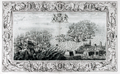 | Details | Pine, John | 1739 |
| John Pine Armada Engraving Plate IX- Calais, France |
|
Pine, John |
|
| 1739 |
| LOC:55 |
| $1,550.00 | Pine--John | John-Pine-Armada-Engraving-Plate-IX--Calais--France | Beautiful intaglio engraving commemorating the defeat of the "Invincible Armada" of Spain by Britain in 1588 during the reign of Elizabeth I. This original antique copper-plate engraving was drawn by Lempriere, engraved and published by <b>John Pine</b> of London in 1739 in his folio volume titled "The Tapestry Hangings of the House of Lords, Representing the Several Engagements between the English and Spanish Fleets in the memorable year MDLXXXVIII".
<br></br>
The battle scene depicts an action on the night of August 7th and 8th, 1588 that marked the key turning point in the campaign. The Spanish Fleet, anchored just offshore the French town of Calais, France was forced to flee after Admiral Howard set fireships ablaze and caused them them to drift down on the anchored Spanish Armada. The fear of explosion and fire so panicked the Spanish Captains that they cut their anchors in haste and scattered in confusion. The scene depicts the fireships between the British fleet at left and the <b>Spanish Armada</b> at right.
<br></br>
Two attributes of Pine's 'Armada" engravings make them very special. First, the great detail, elaborate design and brilliant execution of the work has led these prints to be considered by many to be among the very finest engraved works of the 18th century. Second, the printing process used a two-plate technique that is extremly rare, whereby the interior battle scene was printed separately from the background frame in a beautiful blue-green ink, using an additional plate. The two plate-marks are each clearly visible.
<br></br>
John Pine (1690-1756) was a well respected English engraver and publisher who operated a shop in London and is widely considered to be the finest engraver of his period. At bottom center reads: "Published by John Pine, June 24, 1739 according to an Act of Parliament". |
| 746 |  | Details | Pine, John | 1739 |
| John Pine Armada Engraving Plates IX and X |
|
Pine, John |
|
| 1739 |
| LOC:0 |
| $1,250.00 | Pine--John | John-Pine-Armada-Engraving-Plates-IX-and-X | Stunning, beautifully engraved and deftly hand-colored intaglio engraving commemorating the defeat of the "Invincible Armada" of Spain by Britain in 1588 during the reign of Elizabeth I. This original antique copper-plate engraving was engraved and published by John Pine of London in 1739 in his folio volume titled "The Tapestry Hangings of the House of Lords, Representing the Several Engagements between the English and Spanish Fleets in the memorable year MDLXXXVIII".
<br></br>
Two inset charts depict the actions of August 6 - 9, 1588 when the Spanish Armada, anchored off Calais, France was attacked by eight English fireships and on the following day was attacked off Gravelines, France. Those two days are considered the decisive points that lead to the ultimate destruction of the Spanish Armada.
<br></br>
Two attributes of Pine's 'Armada" engravings make them very special. First, the great detail, elaborate design and brilliant execution of the work has led these to be considered by many to be among the very finest engraved works of the 18th century. Second, the printing process used a muliple plate printing process that is rarely encountered. The two inset charts (IX and X) were each printed separately from the background in a beautiful blue ink. The separate plate-marks of the two inset charts are clearly visible and noticeable to the touch.
<br></br>
At bottom center reads: "Published by John Pine, June 24, 1739 according to an Act of Parliament". |
| 747 |  | Details | Pine, John | 1739 |
| John Pine Armada Engraving Plates III and IV |
|
Pine, John |
|
| 1739 |
| LOC:0 |
| $1,250.00 | Pine--John | John-Pine-Armada-Engraving-Plates-III-and-IV | Stunning, beautifully engraved and deftly hand-colored intaglio engraving commemorating the defeat of the "Invincible Armada" of Spain by Britain in 1588 during the reign of Elizabeth I. This original antique copper-plate engraving was engraved and published by John Pine of London in 1739 in his folio volume titled "The Tapestry Hangings of the House of Lords, Representing the Several Engagements between the English and Spanish Fleets in the memorable year MDLXXXVIII".
<br></br>
Two inset charts depict the actions on July 29 and 30, 1588 when the English Fleet, set sail from Plymouth, England to meet the Spanish Armada in the English Channel. These inset charts show details of both fleets with the Spanish ships formed into a crescent-shaped formation that they felt would offer the best protection and favor their strategy of overpowering the English ships by boarding. The weather played an important role in the English victory, reinforced by drawings of a cherub puffing away.
<br></br>
Two attributes of Pine's 'Armada" engravings make them very special. First, the great detail, elaborate design and brilliant execution of the work has led these prints to be considered by many to be among the very finest engraved works of the 18th century. Second, the printing process used a triple-plate technique that is extremly rare, whereby each of the two inset charts (III and IV) were printed separately from the background in a beautiful blue ink, using an additional plate. The plate-marks of these two insets are clearly visible.
<br></br>
At bottom center reads: ""Published by John Pine, June 24, 1739 according to an Act of Parliament". |
| 1156 | 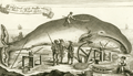 | Details | Anonymous | 1744 |
| A Whale Female and the Windlass whereby the Whales are brought on shore |
|
Anonymous |
|
| 1744 |
| LOC:1 |
| $275.00 | Anonymous | A-Whale-Female-and-the-Windlass-whereby-the-Whales-are-brought-on-shore | Fine antique copper-plate engraving of a dead whale lying on the Greenland shore prior to flensing. A worker has marked a grid on the whale and is about to begin work removing the blubber with a large flensing tool. Shore-based flensing or cutting of the whales flesh was the method used by Nantucketer's during their early shore fishery . As the fishery moved offshore flensing was conducted by bringing the whale alongside the whaling ship. Illustrates Monck's "Account of a Most Dangerous Voyage to Greenland".
<br></br>
Shows windlasses, a sled, anchor, and flensing tools used to haul the carcass ashore and remove the whale's blubber.
<br></br>
Originally published in 1619, this state is from Churchill's Collection of Voyages & Travel (1744) vol. I. Page 444. |
| 4709 | 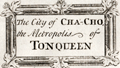 | Details | Baron, Samuel | 1744 |
| Earliest engraved view of Hanoi, Vietnam |
|
Baron, Samuel |
|
| 1744 |
| LOC:9 |
| $600.00 | Baron--Samuel | Earliest-engraved-view-of-Hanoi--Vietnam | A fine example of the earliest engraved view of Hanoi, Vietnam. Shows important buildings in Hanoi of the time identified in the key at center left: Sandy Bay, the King's Arsenal, the King's Elephant's Stables and the English and Dutch Factories. Contains interesting representations of indigenous rowed galleys of that era.
<br></br>
This antique view, "The City of Cha-Cho the Metropolis of Tonqueen", is a copper-plate etched print, by Samuel Baron. Baron published his account of mid-17th century Hanoi in 'A Description of the Kingdom of Tonqueen, by Samuel Baron, A Native Thereof'. Published from London in 1744 by Awnsham and John Churchill. Page 122.
<br></br>
In his description of the Kingdom of Tonqueen, Samuel Baron described the city of Hanoi (Ca-Cho) for a European audience, particularly with regard to its commercial potential.
<div class="indenttextblock">
"… the city of Ca-cho is the metropolis of Tonqueen, lieth in the latitude 21 degrees north, about 40 leagues from the sea, and may, for its capaciousness be compared with many cities in Asia, and superior to most for populousness, especially on the first and fifteenth of their new moon; being their market days or grand Bazaar; when the people from adjacent villages flock thither with their trade in such numbers as is almost incredible; several of the streets, tho' broad and spacious, are then so crowded that one finds enough to do if he can sometimes advance through the multitude a hundred paces in half an hour. </div><i>(Source: Online. https://books.google.com/books?id=BjvctNaIVAcC)</i> |
| 129 |  | Details | Lotter, T.C. | 1749 |
| Novissimum Astronomiae |
|
Lotter, T.C. |
|
| 1749 |
| LOC:55 |
| $475.00 | Lotter--T-C- | Novissimum-Astronomiae | Contemporary hand color enlivens this dense chart of Astronomical and Geographic theory. Graphic elements that make the mid-eighteenth century Latin explanations spring to life include a backstaff, sundial and astronomical diagram. Single vertical centerfold. |
| 1472 | 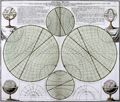 | Details | Doppelmayr, Johann Gabriel | 1750 |
| Sphaera Mundi or Sphere of the World |
|
Doppelmayr, Johann Gabriel |
|
| 1750 |
| LOC:55 |
| $375.00 | Doppelmayr--Johann-Gabriel | Sphaera-Mundi-or-Sphere-of-the-World | Attractive, interesting print related to astronomy. This antique engraved plate demostrates graphically the description of and the basic terms related to the imaginary structure we use to map the earth. Concepts such as the equator, the two Tropics, the Poles, the horizon, etc. Based on work by Johann Doppelmayr.
<br></br>
Johann Doppelmayr (1677-1750) was a Professor of Mathematics in Nuremberg and a member of the Royal Society of London. He wrote on astronomy, geography, cartography, spherical trigonometry, and scientific instruments, and collaborated in the production of terrestrial and celestial globes. Later edition.
<br></br>
Doppelmayr prepared a number of astronomical and cosmological plates that appeared in several works by cartographer Johann Baptist Homann. In 1742, these plates were issued as the "Atlas Novus Coelestis". This atlas had a total of 30 plates, 20 that dealt with various astronomical themes (e.g., cosmological systems of Copernicus and Tycho Brahe, planetary and other bodies in the solar system), and 10 that were constellation maps showing the positions of the stars and the paths of comets." (Kanas, Nick. David Rumsey Map Collection). |
| 411 |  | Details | Anonymous | 1750 |
| A Prospect of Mount Vesuvius with its Irruption in 1630 |
|
Anonymous |
|
| 1750 |
| LOC:50 |
| $225.00 | Anonymous | A-Prospect-of-Mount-Vesuvius-with-its-Irruption-in-1630 | Hand colored engraving depicting the eruption of Mount Vesuvius near Naples, Italy more than a century earlier. From the April 1750 edition of Gentleman's Magazine. Features depicted include the catastrophic explosion of Vesuvius, the Torre del Greco (Greek Tower) covered with ashes, two barges on which several people saved themselves, and the bridge "la Nunciato". |
| 471 |  | Details | Anonymous | 1750 |
| La Boussole |
|
Anonymous |
|
| 1750 |
| LOC:1 |
| $55.00 | Anonymous | La-Boussole | Mid 18th century hand-colored copperplate engraving of a ship's compass mounted in a binnacle. Detailed views of the compass card and compass needle. |
| 4864 |  | Details | Vivarez, Henry Emile | 1750 |
| View of Dunkirk |
|
Vivarez, Henry Emile |
|
| 1750 |
| LOC:88 |
| $195.00 | Vivarez--Henry-Emile | View-of-Dunkirk | Original, antique vue d-optique of Dunkerque (Dunkirk), France. Shows long piers protecting a channel into Dunkirk harbor. From Choix de vues d'optique des XVIIIe et XIXe siècles. Tome 4. By Henry Emile Vivarez. |
| 470 |  | Details | Delisle, Guillaume | 1750 |
| Title Page-Atlante Novissimo |
|
Delisle, Guillaume |
|
| 1750 |
| LOC:1 |
| $175.00 | Delisle--Guillaume | Title-Page-Atlante-Novissimo | Undated decorative copperplate title-page from Delisle's Atlas 'Atlante Novissimo'. The atlas was published from Venice, Italy in 1750. As the author's name is spelled 'Guglielmo' we assume this engraving is from an Italian edition of the atlas. Bottom vignette contains a view of St. Marks square in Venice with the Campanile to the left. |
| 5238 | 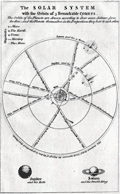 | Details | London Magazine | 1752 |
| Antique engraved plate of the Solar System and comets |
|
London Magazine |
|
| 1752 |
| LOC:0 |
| $150.00 | London-Magazine | Antique-engraved-plate-of-the-Solar-System-and-comets | Original antique copper-plate engraved view titled: "The solar system with the orbits of 5 remarkable comets." The print explains the drawing:
<div class="indenttextblocksingle">
"The orbits of the Planets are drawn according to their mean distance from the Sun; and the Planets themselves in the proportions they bear to each other."
</div></br>
Illustrates the Copernican heliocentric theory of the solar system. Interesting representation of five periodic appearances of comets with their periodicity and generalized orbits.
<br></br>
Published in the February, 1752 issue of London Magazine to illustrate an article: "The Solar System according to Copernicus." |
| 109 | 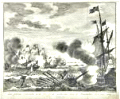 | Details | Tirion, Isaac | 1752 |
| Zes galeien overzeild en in den grond geshooten |
|
Tirion, Isaac |
|
| 1752 |
| LOC:1 |
| $200.00 | Tirion--Isaac | Zes-galeien-overzeild-en-in-den-grond-geshooten | Fine antique engraving by Isaac Tirion of an encounter between Dutch ships and eight Spanish galleys on October 3, 1602 in the English Channel off the coast of Dover. The galleys proved to be no match for the larger Dutch ships. In that battle three Spanish galleys were lost. |
| 5106 |  | Details | Collins, Greenvile | 1753 |
| Engraved Frontispiece for Great Britains Coasting Pilot |
|
Collins, Greenvile |
|
| 1753 |
| LOC:88 |
| $350.00 | Collins--Greenvile | Engraved-Frontispiece-for-Great-Britains-Coasting-Pilot | Fine original engraved frontispiece for "Great Britains Coasting Pylot being a new survey of the sea coast by Greenvile Collins Hydrographer to His Majesty." With Poseidon, Britannia, sea nymphs, putti, trumpets, navigation instruments, a chart of the U.K. and one trident. Very attractive.
<br></br>
Sold by William Mount and Thomas Page on Tower Hill, London. |
| 1126 |  | Details | Le Rouge, George | 1760 |
| Terrestrial and celestial globes |
|
Le Rouge, George |
|
| 1760 |
| LOC:0 |
| $180.00 | Le-Rouge--George | Terrestrial-and-celestial-globes | Antique old French copper-plate engraving ca. 1748 of two globes: a terrestrial globe and a celestial globe. A celestial globe is a spherical representation of the celestial sphere, showing the apparent positions of the stars and constellations in the sky. The engraving includes additional representations: of the points of the compass, a solar eclipse, lunar eclipse, and the relative sizes of the astronomical bodies.
<br></br>
From le Rouge's "Atlas Nouveau Portatif à l'usage des militaires et du voyageur" published from Paris. George Le Rouge was a Paris-based engineer and surveyor originally from Germany who had a shop on the Rue Des Grands Augustins. Le Rouge's tireless work earned him the title "Geographe du Roi". |
| 1251 | 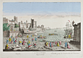 | Details | Daumont, Jean-Francois | 1760 |
| Antique optical view of naval ship construction |
|
Daumont, Jean-Francois |
|
| 1760 |
| LOC:9 |
| $320.00 | Daumont--Jean-Francois | Antique-optical-view-of-naval-ship-construction | Fine French antique optical print (vue d'optique) of an mid eighteenth-century shipyard with ship's carpenters planking the hull a 20-gun warship while two other ships are shown being framed in the background. This interesting scene shows workmen using adzes and board saws to prepare various ship's structural frame members while typical port actvities are underway on all sides.
<br></br>
Although the location is undocumented the print could be based on ship-building activities at Toulon, the home base of France's fleet of warships during that period.
<br></br>
This scarce engraved print was published by Jean-Francois Daumont with attribution at bottom right reading: "A Paris chez Daumont rue St. Martin". |
| 1475 | 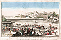 | Details | Huquier Fils. | 1760 |
| Antique vue d'optique of the Port of Beijing Pekin, China |
|
Huquier Fils. |
|
| 1760 |
| LOC:6 |
| $320.00 | Huquier-Fils- | Antique-vue-d-optique-of-the-Port-of-Beijing-Pekin--China | Scarce French vue d'optique or optical print ca. 1760 of the Port of Pekin or Beijing, China. Engraved by the sons of Jacques Gabriel Huquier. In the foreground of this colorful original antique engraving numerous covered boats are unloaded by a variety of workers dressed in colorful native apparel.
<br></br>
Attribution at bottom reads "A Paris ches Huquier Fils, Graveur rue St. Jacques, au Grand St. Remy." Jacques Gabriel Huquier (1725 - 1805) was an engraver and printseller located at Rue St. Jacques in Paris, France. Jacques-Gabriel fils was the son of J. Gabriel Huquier, also a printseller and engraver who worked from the same address. According to Jeffares, Jacques-Gabriel Huquier made a fortuitous marriage in 1758:
<div class="indenttextblock">"[J.G. Huquier] married Anne-Louise, the daughter of the engraver Jacques Chéreau. She brought a dowry of 10,000 livres, mostly in stock in the business at rue Saint-Jacques, “au Grand Saint-Rémy”, and for the next three years with Huquier fils and Chéreau collaborated as engravers and printsellers." (Source : http://www.pastellists.com/Articles/HUQUIER.pdf.)
</div>
By 1772 Huquier had abandoned his family and emigrated to England. Screenplay in progress. |
| 1247 | 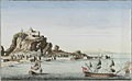 | Details | Huquier, Jacques-Gabriel | 1760 |
| Antique optical print view of the Rock of Gibraltar |
|
Huquier, Jacques-Gabriel |
|
| 1760 |
| LOC:9 |
| $350.00 | Huquier--Jacques-Gabriel | Antique-optical-print-view-of-the-Rock-of-Gibraltar | Lovely vue d'optique or optical print ca. 1760 of the Rock of Gibraltar with the walled city of Gibraltar depicted below. In the foreground ships-of-the-line are shown underway.
<br></br>
Attribution at bottom reads "A Paris ches Huquier Graveur fils rue St. Jacques, au dessus celle des Mathurins au Gd. St. Remy." Jacques Gabriel Huquier (1725 - 1805) was an engraver and printseller located at Rue St. Jacques in Paris, France. Jacques-Gabriel fils was the son of Gabriel Huquier, also a printseller and engraver who worked from the same address. According to Jeffares, Jacques-Gabriel Huquier made a fortuitous marriage in 1758:
<div class="indenttextblock">"[J.G. Huquier] married Anne-Louise, the daughter of the engraver Jacques Chéreau. She brought a dowry of 10,000 livres, mostly in stock in the business at rue Saint-Jacques, “au Grand Saint-Rémy”, and for the next three years with Huquier fils and Chéreau collaborated as engravers and printsellers." <a href="http://www.pastellists.com/Articles/HUQUIER.pdf" target="_blank">Online source.</a>
</div>
By 1772 Huquier had abandoned his family and emigrated to England. |
| 858 | 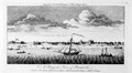 | Details | Universal Magazine | 1764 |
| Antique engraved elevation view of Pensacola, Florida |
|
Universal Magazine |
|
| 1764 |
| LOC:3 |
| $360.00 | Universal-Magazine | Antique-engraved-elevation-view-of-Pensacola--Florida | Antique elevation view of Pensacola, Florida and the very few structures that existed 250 years ago just after the end of Spanish rule over the city. A legend at bottom is keyed to six locations on the view including: 1. The Fort. 2. The Church. 3. The Governor's House. 4. The Commandant's House. 5. A Well. 6. A Bungo. (A bungo was a type of boat or canoe used in the southern United States made of a hollowed-out tree.)
<br></br>
This engraving is the earliest available printed view of Pensacola and comes from the January 1764 issue of the Universal Magazine. After Dominic Serres (1719-1793), a French-born painter primarily of nautical or maritime subjects. Serres was assigned to the Brtitish expedition to capture Havana, led by Admiral Sir George Pocock. It is possible that Serres visited Pensacola during that cruise. |
| 1427 | 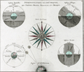 | Details | Brion, Louis, de la Tour | 1766 |
| 18th-century astronomical engraving of spherical orientations |
|
Brion, Louis, de la Tour |
|
| 1766 |
| LOC:9 |
| $250.00 | Brion--Louis--de-la-Tour | 18th-century-astronomical-engraving--of-spherical-orientations | Attractive antique engraving ca. 1766 related to astronomy and in particular to the viewer's perception of various two-dimensional orientations of the earth including the oblique and parallel projections.
<br></br>
Brion's diagrams are organized around a large, attractive, and very decorative compass rose. Additionally, a large and decorative border surrounds the entire print. Two plates were used in the production of this print, one plate for the border, evidenced by the nesting platemarks plainly visible to the viewer. Number 4.
<br></br>
From the "Atlas général civil et ecclésiastique" by Louis Brion de la Tour, Ingénieur-géographe du Roi. |
| 1369 | 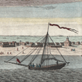 | Details | Tirion, Isaac | 1767 |
| Very early view of Pensacola, Florida from 1767 |
|
Tirion, Isaac |
|
| 1767 |
| LOC:11 |
| $260.00 | Tirion--Isaac | Very-early-view-of-Pensacola--Florida-from-1767 | Antique elevation view of Pensacola, Florida on the Florida Panhandle. This attractive engraved view documents the very few structures that existed in that Gulf of Mexico port 250 years ago just after the end of Spanish rule over the city. German text.
<br></br>
From the English-language edition of this view we learn the names of six objects or locations on the view: 1. The Fort. 2. The Church. 3. The Governor's House. 4. The Commandant's House. 5. A Well. 6. A Bungo. (A bungo was a type of boat or canoe used in the southern United States made of a hollowed-out tree.)
<br></br>
This engraving is the one of the earliest available printed views of Pensacola.
<br></br>
After Dominic Serres (1719-1793), a French-born painter primarily of nautical or maritime subjects. Serres was assigned to the Brtitish expedition to capture Havana, led by Admiral Sir George Pocock. It is possible that Serres visited Pensacola during that cruise. |
| 1204 | 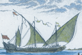 | Details | Ozanne, Nicolas | 1770 |
| Antique French Engraving of a Galeasse |
|
Ozanne, Nicolas |
|
| 1770 |
| LOC:0 |
| $175.00 | Ozanne--Nicolas | Antique-French-Engraving-of-a-Galeasse | This fine 18th-century hand-colored engraving of a Galeasse of about 165 feet in length is described in the engraved text:
<div class="indenttextblock">
Les Galeasses, sont de tres grands Batiments, qui vont a voiles et a rames; leur longueur, est de 160, a 170 pieds, la largeur de 30, a 34, et la creuse de 10 a 12. Ces Batiments, portent leur grosse artillerie a la poupe a la proue; les canons de petit calibre se placent sur les flancs, entre les bancs de rameurs, on na point rendu de detail ici pareeque la Figue est trop petit cela.
</div>
<br></br>
A galeasse is a larger vessel than a galley (galère, Fr.) typically powered by 3 lateen-rigged sails as well as oars.
<br></br>
Form Nicolas Ozanne's "Marine Militaire ou Recueil des differens vaisseaux qui servent à la guerre suivis des manoeuvres qui ont le plus de raport au combat ainsi qua l'attaque et la defense des ports" ca. 1770. Plate 16. |
| 1171 | 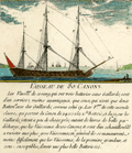 | Details | Ozanne, Nicolas | 1770 |
| Vaisseau de 80 Canons |
|
Ozanne, Nicolas |
|
| 1770 |
| LOC:1 |
| $150.00 | Ozanne--Nicolas | Vaisseau-de-80-Canons | This fine 18th-century hand-colored engraving of a French 80-cannon three-masted war ship is described in the engraved text, including use, armament, names of sail and mastage and crew complement. Several key locations on the rigging are identified in a legend below.
<br></br>
Form Ozanne's "Marine Militaire ou Recueil des differens vaisseaux qui servent à la guerre suivis des manoeuvres qui ont le plus de raport au combat ainsi qua l'attaque et la defense des ports" ca. 1770. Plate 7. |
| 1179 | 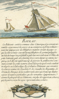 | Details | Ozanne, Nicolas | 1770 |
| French Bateau or Sloop |
|
Ozanne, Nicolas |
|
| 1770 |
| LOC:1 |
| $175.00 | Ozanne--Nicolas | French-Bateau-or-Sloop | This fine 18th-century hand-colored engraving of a French "Bateau" is described in the engraved text. Engraved scene at bottom shows a small swivel cannon and a very scare depiction of a four-barreled naval blunderbuss, the fore-runner of the modern shotgun
<br></br>
From Ozanne's "Marine Militaire ou Recueil des differens vaisseaux qui servent à la guerre suivis des manoeuvres qui ont le plus de raport au combat ainsi qua l'attaque et la defense des ports" ca. 1770. Plate 20. |
| 1180 | 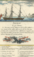 | Details | Ozanne, Nicolas | 1770 |
| Antique Engraving of a French War Ship with 90 Cannons |
|
Ozanne, Nicolas |
|
| 1770 |
| LOC:1 |
| $175.00 | Ozanne--Nicolas | Antique-Engraving-of-a-French-War-Ship-with-90-Cannons | This fine 18th-century hand-colored engraving of a French "Vaisseau de 90 Canons" is described in the engraved text, including maneuvering tactics. Legend at bottom of the engraving identifies several key locations on the rigging of this triple decked French ship-of-the-line including:
<div class="indenttextblock">
<ul style="list-style-type: circle;">
<li>le grand mat d'hune- Main top mast </li>
<li>Petit mat d'hune - Fore top mast</li>
<li>Mat de Perroquet d'artimon ou de Fouge - Mizzen top-gallant mast </li>
<li>Haubans des mats cy dessus - Mast stays</li>
<li>Galaubans des memes mats - Mast backstays </li>
<li>Trelingages des hunes - Top cordage</li>
</ul>
</div>
Form Nicolas Ozanne's "Marine Militaire ou Recueil des differens vaisseaux qui servent à la guerre suivis des manoeuvres qui ont le plus de raport au combat ainsi qua l'attaque et la defense des ports" ca. 1770. |
| 448 | 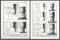 | Details | Benard, Robert | 1770 |
| Fonte des Canons |
|
Benard, Robert |
|
| 1770 |
| LOC:0 |
| $875.00 | Benard--Robert | Fonte-des-Canons | A fine gift for anyone with an interest in engineering, weaponry, or European history. A scarce pair (2) of archivally-matted antique copperplate engravings by Robert Benard depicting large mortars ca. 1738. In the early 18th century a mortar was essentially a squat, wide tube with very thick walls to withstand high pressure.
<br></br>
<img src="/ZoomifyImages/SC_309/SC_309_400x300.jpg" alt="de Passebon: Bomb Ketch. 1690." width="200" align="bottom" style="margin: 5px 10px 5px 0px"> </BR>
<a href="https://www.rarecharts.com/ShowDetail/Creator/Henri-Sbonski-de-Passebon/Title/Galiote-a-bombe/309" target="_blank">The 'Galiote a bombe' </a>(bomb vessel or bomb ketch) pictured inset is an antique engraving in our inventory created ca. 1690 by French galley Captain Henry Sbonski de Passebon (1637-1705). Either one or two mortars were usually placed aboard a bomb vessel which could be one of two types of vessels, either a specially built ketch (ketch: a two-masted, fore-and-aft-rigged sailboat with a mizzenmast smaller than the foremast) or, as is the case here, a converted three-masted vessel where the foremast had been removed, to provide a good deck space forward for the mortars.
<BR> </BR>
As a Captain in France's Corps des Galere, de Passebon was intimately familiar with this type ship and he is reported to have participated during the French bombardment of Genoa in 1684 , aboard the "la Perle" .
</BR>
The cannon are decorated with crown and globe containing three fleur-de-lis, figures representing the French royal coat of arms in the eighteenth century. From Diderot's "Encyclopédie ou Dictionnaire raisonné des sciences, des arts et des métiers, par une Société de Gens de lettres. Total dimensions with mat about 16.5" W x 19.5" H. Mat approx 5" per side. "Benard direxit". |
| 445 |  | Details | Bellin, Jacques Nicolas | 1772 |
| Hydrographie Francoise (Title Page) |
|
Bellin, Jacques Nicolas |
|
| 1772 |
| LOC:55 |
| $400.00 | Bellin--Jacques-Nicolas | Hydrographie-Francoise-(Title-Page) | Gorgeous copperplate re-strike engraving of the title page to Bellin's sea-atlas, the Hydrographie Francoise. With the circular stamp of the Depot de la Marine. Undated. Price One and one-half francs. No. 1.
<BR> </BR>
We believe the engraving is an early 20th century re-strike from the original copper plate produced at the French Chalcographie du Louvre. La Chalcographie du Louvre is a repository, consisting of more that 13,000 original plates from the Louvre's archives, housed upstairs above the Louvre's Paris galleries . Upon request visitors can have an engraving produced from the original plate on museum-quality paper by a master printer. V.196. |
| 1124 | 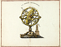 | Details | Anonymous | 1777 |
| Ptolemaic armillary sphere |
|
Anonymous |
|
| 1777 |
| LOC:1 |
| $100.00 | Anonymous | Ptolemaic-armillary-sphere | Finely engraved Ptolemaic armillary sphere. This early engraving served as the source for a later similar image with celestial and terrestrial globes, published by Citoyen (Citizen) Berthelon in Paris ca. 1799, for the "Nouvelle Edition" of the Atlas Modern Portatif.
<br></br>
An armillary sphere is a model of objects in the sky consisting of a spherical framework of rings, centered on the Earth or the Sun, that represent lines of celestial longitude and latitude and other astronomically important features such as the ecliptic. As such, the armillary sphere differs from a celestial globe, which is a smooth sphere whose principal purpose is to map the constellations.
<br></br>
With the Earth at the center, an armillary sphere is known as a Ptolemaic sphere. With the sun at center, it is known as a Copernican sphere. |
| 1234 | 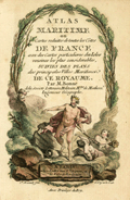 | Details | Bonne, Rigobert | 1778 |
| Antique title page to the miniature Atlas Maritime |
|
Bonne, Rigobert |
|
| 1778 |
| LOC:7 |
| $200.00 | Bonne--Rigobert | Antique-title-page-to-the-miniature-Atlas-Maritime | Scarce antique miniature title page to Rigobert Bonne's miniature sea atlas of coastal France. Bonne's scarce atlas contained 12 miniature nautical charts of coastal France and 18 miniature plates of port and harbor plans. With Table of Contents, colored attractive frontispiecce, and end notes.
<br></br>
From Rigobert Bonne's miniature nautical atlas "Atlas maritime ou Cartes réduites de toutes les Côtes de France avec des cartes particulières des isles voisines les plus considérables, suivies des plans des principales villes maritimes de ce royaume." Published by Lattre from Paris. With the royal privilege. Engraved by Monnet after a design by L. Legrand.
<br></br>
Rigobert Bonne was the successor to Jacques Nicolas Bellin as Royal Cartographer to France in the office of the Hydrographer at the Depôt de la Marine. |
| 3677 | 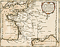 | Details | Bonne, Rigobert | 1778 |
| Antique master or key chart to the Petit Atlas Maritime |
|
Bonne, Rigobert |
|
| 1778 |
| LOC:7 |
| $160.00 | Bonne--Rigobert | Antique-master-or-key-chart-to-the-Petit-Atlas-Maritime | Scarce antique miniature master page to Rigobert Bonne's miniature sea atlas of coastal France. Bonne's scarce atlas contained 12 miniature nautical charts of coastal France and 18 miniature plates of port and harbor plans. On this master map nine rectangles show the viewer the area encompassed by each of Bonne's nine charts as shown in our inventory.
<br></br>
From Rigobert Bonne's miniature nautical atlas "Atlas maritime ou Cartes réduites de toutes les Côtes de France avec des cartes particulières des isles voisines les plus considérables, suivies des plans des principales villes maritimes de ce royaume." Published by Lattre from Paris. With the royal privilege. Engraved by Monnet after a design by L. Legrand.
<br></br>
Rigobert Bonne was the successor to Jacques Nicolas Bellin as Royal Cartographer to France in the office of the Hydrographer at the Depôt de la Marine. |
| 3648 | 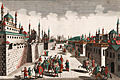 | Details | Probst, Georg Balthasar | 1780 |
| Fine vue d'optique of Constantinople now Istanbul |
|
Probst, Georg Balthasar |
|
| 1780 |
| LOC:88 |
| $375.00 | Probst--Georg-Balthasar | Fine-vue-d-optique-of-Constantinople-now-Istanbul | Fine antique 'vue d'optique' of a street in Constantinople, 'from the Mosque of Mechemet and Selim'. In the foreground is a heavily-guarded caravan of camels. Constantinople, conquered in 1453 by the Ottomans, is today modern Istanbul, Turkey. By Georg B. Probst. Folio No. 54.
<br></br>
This type of print was designed to be looked at through a zograscope, a device designed to give an illusion of depth using mirrors and lenses. The image and title at the top have been transposed left to right. The prints were placed into a view box and the viewers for a small price, could look through a lens to see the print.
<br></br>
Georg Balthasar Probst was the most important member of an Augsburg family of artists and publishers. Probst produced about 400 vue's d'optique on varied subject matter. |
| 3649 |  | Details | Probst, Georg Balthasar | 1780 |
| Unusual vue d'optique of the Egyptian Pyramids |
|
Probst, Georg Balthasar |
|
| 1780 |
| LOC:88 |
| $400.00 | Probst--Georg-Balthasar | Unusual-vue-d-optique-of-the-Egyptian-Pyramids | The "third wonder of the world". That’s how Probst describes the Egyptian Pyramids in this vue d'optique, made about 1780. This colorful antique view reflects the limited knowledge of a late 18th century European and errs most egregiously in the height to width ratio of the pyramids, of which Probst obviously had no first hand experience. Really quite a theatrical setting. By Georg B. Probst. Folio no. 43.
<br></br>
A vue d'optique is a print was designed to be looked at through a zograscope, a device designed to give an illusion of depth using mirrors and lenses. The image and title at the top of the vue have been transposed left to right. The prints were placed into a view box and for a small price viewers could look through a lens to see the print. Zograscopes were used as entertainment in Georgian times and collections of these prints could be hired for the evening from print sellers.
<br></br>
Georg Balthasar Probst was the most important member of an Augsburg family of artists and publishers. Probst produced about 400 vue's d'optique on varied subject matter. |
| 6333 |  | Details | Mondhare, Louis-Joseph | 1780 |
| Fine vue d'optique of 17th century Cartagena, Colombia |
|
Mondhare, Louis-Joseph |
|
| 1780 |
| LOC:89 |
| $250.00 | Mondhare--Louis-Joseph | Fine-vue-d-optique-of-17th-century-Cartagena--Colombia | Detailed original view of the walled city of Cartagena de Indias, (now in Colombia, SA) during an attack by the French in 1697. This vue d'optique "Vue de la Ville de Carthagene, en Amerique, Prise par les Francois en 1667", was engraved by Louis-Joseph Mondhare (1734- 1799) ca. 1780. |
| 468 |  | Details | Lodge, J. | 1780 |
| Facing Cannon |
|
Lodge, J. |
|
| 1780 |
| LOC:50 |
| $150.00 | Lodge--J- | Facing-Cannon | Copperplate engraving depicting design and cutaway views of a British field cannon ca. 1780 by London engraver John Lodge. This 18th century engraving shows three views of a highly decorated cannon measuring over 11 feet long, adorned with many decorations including the British royal arms and two dolphins (lifting handles) mounted above the trunnions. Includes two side elevation views of cannon on field carriages. A small detail on the drawings shows the arrangement of a "burning glass" or magnifying glass on the touch-hole that could be used to fire the cannon. |
| 536 | 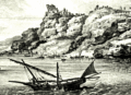 | Details | Choiseul-Gouffier, Marie Gabriel Florent Auguste | 1782 |
| Vue de la Cote de Santorin |
|
Choiseul-Gouffier, Marie Gabriel Florent Auguste |
|
| 1782 |
| LOC:9 |
| $180.00 | Choiseul-Gouffier--Marie-Gabriel-Florent-Auguste | Vue-de-la-Cote-de-Santorin | View of Santorini, Greece, an island in the Aegean Sea. Detailed and picturesque coastal view of villages and windmills perched above a rocky shore on the island of Santorini, Greece in the vicinity of the towns of Oia and Pyrgos. Engraved copperplate etching from the late 18th century. Engraved by J.B. Tilliard from the design by Choiseul-Gouffier.<br><br/>
From le Comte de Choiseul-Gouffier's "Voyage Pittoresque dans l'Empire Ottoman, en Grèce, dans la Troade, les îles de l'Archipel et sur les côtes de l'Asie-Mineure ". Printed before the French revolution with the royal license, "A.P.D.R." or "Avec Privilege Du Roi". Plate 16.<br><br/> |
| 537 |  | Details | Choiseul-Gouffier, Marie Gabriel Florent Auguste | 1782 |
| Plan du Golfe et des Isles de Santorin |
|
Choiseul-Gouffier, Marie Gabriel Florent Auguste |
|
| 1782 |
| LOC:9 |
| $325.00 | Choiseul-Gouffier--Marie-Gabriel-Florent-Auguste | Plan-du-Golfe-et-des-Isles-de-Santorin | Detailed antique map of the north-west coast of the Aegean island of Santorini Greece. Beautifully hachured relief shows offshore islands, villages, windmills, and fields above a rocky shore from the town of Oia (Apanomeria / San Nicolo) to about one French lieue south of the village of Pyrgos. Noted features include the Chateau de Scaro, Maison des Jesuites, and a small anchorage.<br><br/>
Finely engraved copperplate etching from the late 18th century. Engraved by J. Perrier from the survey laid down by F. Kauffer in 1776. <br><br/>
From le Comte de Choiseul-Gouffier's "Voyage Pittoresque dans l'Empire Ottoman, en Grèce, dans la Troade, les îles de l'Archipel et sur les côtes de l'Asie-Mineure ". Printed before the French revolution with the royal license, "A.P.D.R." or "Avec Privilege Du Roi". Plate 13. |
| 429 |  | Details | Senex, John | 1786 |
| Celestial Globe |
|
Senex, John |
|
| 1786 |
| LOC:1 |
| $90.00 | Senex--John | Celestial-Globe | Small delicate copperplate engraving of a John Senex armillary sphere possibly by Guthrie. Senex (1690-1740) was a successful London Fleet-street engraver and globe maker. |
| 2550 | 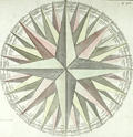 | Details | Clouet, Jean-Baptiste | 1787 |
| Fine antique print of a wind rose. |
|
Clouet, Jean-Baptiste |
|
| 1787 |
| LOC:9 |
| $270.00 | Clouet--Jean-Baptiste | Fine-antique-print-of-a-wind-rose- | Large delicately colored original engraved example of a wind rose by J.B. Clouet. The 32 winds of the wind rose are each named in French, Italian, Latin, and Spanish (e.g. for the West wind: "Ouest", "Ponente", "Favonius Zephirus" and "Oeste"). This fine antique wind rose is surrounded on two sides by French text and measures 12 inches in diameter. |
| 437 |  | Details | Anonymous | 1790 |
| Au nom du Peuple Francais |
|
Anonymous |
|
| 1790 |
| LOC:0 |
| $225.00 | Anonymous | Au-nom-du-Peuple-Francais | Large copperplate of Neptune poised on the stern of a French sailing vessel wielding a trident above the French cypher "RF" (Republique Francais). This fine work from the original 18th century plate, is an early 20th century restrike from the original plate by the Louvre of an etching and engraving by Tardieu created ca. 1790. Believe the engraving is similar to the letterhead that Hue designed for the French Ministry of Marine. <BR> </BR>
La Chalcographie du Louvre is a repository of more that 13,000 original plates from the Louvre's archives, housed upstairs above the Louvre's Paris galleries . Upon request visitors can have a engraving produced from one of those original plates by master printers on museum-quality paper. V. 202<BR> </BR> |
| 480 |  | Details | Groenewegen, Gerritt | 1791 |
| Een eenmast koopvaardy Hoeker |
|
Groenewegen, Gerritt |
|
| 1791 |
| LOC:1 |
| $175.00 | Groenewegen--Gerritt | Een-eenmast-koopvaardy-Hoeker | Small, nicely detailed copperplate etching of a Dutch two-masted merchant Hoeker with the mainsail partially furled. From a series of 84 engravings published in seven volumes from 1787 to 1791 by Gerritt Groenewegen (1754 - 1826): "Verscheide soorten van Hollandse Vaartuigen". Note from the stern view the gaff-rigged mizzen-mast and the steering tiller.
<BR> </BR>
On chain-laid paper with a fleur-de-lis watermark. From volume 'B' number 5. |
| 481 | 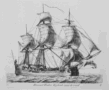 | Details | Groenewegen, Gerritt | 1791 |
| Driemast Hoeker Zeylende voor de wind |
|
Groenewegen, Gerritt |
|
| 1791 |
| LOC:1 |
| $175.00 | Groenewegen--Gerritt | Driemast-Hoeker-Zeylende-voor-de-wind | Small beautifully detailed etching of a large Dutch three-masted merchant Hoeker running before the wind. From a series of 84 engravings published in seven volumes from 1787 to 1791 by Gerritt Groenewegen (1754 - 1826): "Verscheide soorten van Hollandse Vaartuigen". Note the gaff-rigged mizzen-mast, the long steering tiller, and clothes drying above the cabin.
<BR> </BR>
On chain-laid paper with a fleur-de-lis watermark. From volume C, number 8. |
| 482 |  | Details | Groenewegen, Gerritt | 1791 |
| een Kat of houthaalder zyn anker opwindende |
|
Groenewegen, Gerritt |
|
| 1791 |
| LOC:1 |
| $165.00 | Groenewegen--Gerritt | een-Kat-of-houthaalder-zyn-anker-opwindende | Small detailed etched engraving of a large Dutch three-masted kat with the crew hauling the wood-stocked anchor at the port bow. From a series of 84 engravings published in seven volumes from 1787 to 1791 by Gerritt Groenewegen (1754 - 1826): "Verscheide soorten van Hollandse Vaartuigen". Note that the mainsail and foresail are furled and the topsails are at right angle- probably to help the vessel stay in place while weighing anchor.
<BR> </BR>
On chain-laid paper with a fleur-de-lis watermark. From volume E, number 10. |
| 483 |  | Details | Groenewegen, Gerritt | 1791 |
| Boot Schip, zeylende voor de wind |
|
Groenewegen, Gerritt |
|
| 1791 |
| LOC:1 |
| $195.00 | Groenewegen--Gerritt | Boot-Schip--zeylende-voor-de-wind | Small detailed etching of a large Dutch three-masted ship (Boot Schip) running with a heavy breeze from astern- the crew attending to the main top-gallant sail- probably reefing the sail due to the heavy weather. From a series of 84 engravings published in seven volumes from 1787 to 1791 by Gerritt Groenewegen (1754 - 1826): "Verscheide soorten van Hollandse Vaartuigen".
<BR> </BR>
On chain-laid paper with a fleur-de-lis watermark. From volume E, number 8. |
| 484 |  | Details | Groenewegen, Gerritt | 1791 |
| Koopvaardy-buys Zeylende by de wind |
|
Groenewegen, Gerritt |
|
| 1791 |
| LOC:1 |
| $175.00 | Groenewegen--Gerritt | Koopvaardy-buys-Zeylende-by-de-wind | Etching of a Dutch three-masted square-rigged ship running on port tack. <BR> </BR>
From a series of 84 engravings published in seven volumes from 1787 to 1791 by Gerritt Groenewegen (1754 - 1826): "Verscheide soorten van Hollandse Vaartuigen".
<BR> </BR>
On chain-laid paper with a fleur-de-lis watermark. From volume E, number 6. |
| 485 | 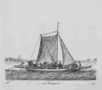 | Details | Groenewegen, Gerritt | 1791 |
| een Veerpont |
|
Groenewegen, Gerritt |
|
| 1791 |
| LOC:1 |
| $225.00 | Groenewegen--Gerritt | een-Veerpont | Detailed etching of a small ferry with both sails and a sweep, or large oar, used to propel and steer the vessel. The ferry is laden with horse-drawn carriages and passengers.
<BR> </BR>
From a series of 84 engravings published in seven volumes from 1787 to 1791 by Gerritt Groenewegen (1754 - 1826): "Verscheide soorten van Hollandse Vaartuigen".
<BR> </BR>
On chain-laid paper with a fleur-de-lis watermark. From volume F, number 12. |
| 486 |  | Details | Groenewegen, Gerritt | 1791 |
| Barkentyn Zeylende by de wind |
|
Groenewegen, Gerritt |
|
| 1791 |
| LOC:1 |
| $215.00 | Groenewegen--Gerritt | Barkentyn-Zeylende-by-de-wind | Small detailed etching of a two-masted 'barkentine' running with in rough weather on starboard tack. In today's terminology this vessel would likely be considered as a brig, a two-masted vessel with square rigged fore and main masts and a gaff-rigged sail on the main mast.
<BR> </BR>
From a series of 84 engravings published in seven volumes from 1787 to 1791 by Gerritt Groenewegen (1754 - 1826): "Verscheide soorten van Hollandse Vaartuigen".
<BR> </BR>
On chain-laid paper with a fleur-de-lis watermark. From volume E, number 7. |
| 487 | 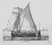 | Details | Groenewegen, Gerritt | 1791 |
| een Beurtschip |
|
Groenewegen, Gerritt |
|
| 1791 |
| LOC:1 |
| $185.00 | Groenewegen--Gerritt | een-Beurtschip | Small detailed etching of a "beurtschip" or sailing barge. Built with a flat bottom and leeboards to compensate for lack of a keel, the beurtship could carry passengers or freight.
<BR> </BR>
From a series of 84 engravings published in seven volumes from 1787 to 1791 by Gerritt Groenewegen (1754 - 1826): "Verscheide soorten van Hollandse Vaartuigen".
<BR> </BR>
On chain-laid paper with a fleur-de-lis watermark. From volume F, number 9. |
| 6748 |  | Details | Bertuch, Friedrich | 1795 |
| Antique copperplate engraving of Cannabis Sativa or chanvre |
|
Bertuch, Friedrich |
|
| 1795 |
| LOC:87 |
| $500.00 | Bertuch--Friedrich | Antique-copperplate-engraving-of-Cannabis-Sativa-or-chanvre | Antique hand-colored engraved plate ca. 1795 containing early depictions of Cannabis Sativa
( chanvre or hemp). A sub-species of weed, wacky tobakky, boucan, dope, marijuana, grass, reefer, pot, maryjane, ganja, etc. Left-most plant depicted is flax. To the right are male and female specimens of Cannabis Sativa. Scarce.
<br><br>
From Bilderbuch fur Kinder, published from 1792-1830 by Friedrich Justin Bertuch (1727-1822). This encyclopedia was published in 237 parts with 1186 engravings.
<br><br>
Two leaves total. Leaf 1 on wove with images, verso blank. Leaf 2 on laid paper with text descriptions in French and German.
<br><br>
Before you forget, fire up your credit card and score this very rare engraving today. Bhang!
<br><br> |
| 124 |  | Details | Anonymous | 1795 |
| External and Internal Views of a first rate Ship of War. |
|
Anonymous |
|
| 1795 |
| LOC:1 |
| $165.00 | Anonymous | External-and-Internal-Views-of-a-first-rate-Ship-of-War- | A detailed copperplate engraving of a first rate British 'line of battle' ship with 3 gun decks. Shows full rigging and a below-decks cross-section. Includes detailed insets of the sail plan, yard rigging and the ship's chain pump. A good find as many similar ship views are steel-plate engravings that lack the character and warmth of this fine late 18th century example.
<br></br>
From Hall's Encyclopedia. |
| 5128 | 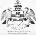 | Details | Laurie and Whittle | 1795 |
| Original Rare 18th Century Heraldic Print A Chart of Blazonry |
|
Laurie and Whittle |
|
| 1795 |
| LOC:62 |
| $1,800.00 | Laurie-and-Whittle | Original-Rare-18th-Century-Heraldic-Print-A-Chart-of-Blazonry | A Chart of Blazonry. Engraved pictorial chart, uncolored, of the components of a blazon or heraldic device. The chart is essentially a reference work, a visual dictionary that allows the conversion of textual descriptions of a blazon into its visual image.
<br></br>
Rare. No copies found anywhere online.
<br></br>
Blazonry, a part of heraldry, is the formal description or illustration of coats of arms. Blazonry embodies a grammar and vocabulary which describe the meaning of a blazon. The field of heraldry, of ancient origin, is the system by which coats of arms and other armorial bearings are devised, displayed, described, recorded and granted.
<br></br>
Published on March 30, 1795 by Laurie and Whittle no. 53 Fleet Street, London.
<br></br>
Engraved by Robinson |
| 438 | 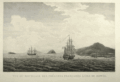 | Details | Blondela, Lieut. | 1797 |
| Vue du Mouillage des Fregates Francaises a L'Isle de Mowee |
|
Blondela, Lieut. |
|
| 1797 |
| LOC:59 |
| $450.00 | Blondela--Lieut- | Vue-du-Mouillage-des-Fregates-Francaises-a-L-Isle-de-Mowee | Engraved re-strike view of ships from the La Perouse expedition anchored off of Maui in the Hawaiian Islands at an anchorage now known as "La Perouse Bay". This is the first large-format view ever published of the island of Maui. From the "Atlas du Voyage de La Perouse". From a drawing by Lieutenant Blondela, Engraved by J.J. Avril; lettered by L. Aubert. No 14. <BR> </BR>
Believe the engraving is an early 20th century re-strike <b> from the original copper plate </b>produced by the Chalcographie du Louvre. La Chalcographie du Louvre is a repository of more that 13,000 original plates from the Louvre's archives, housed upstairs above the Louvre's Paris galleries . Upon request visitors can have a engraving produced from one of those original plates by master printers on museum-quality paper. V. 15<BR> </BR> |
| 441 | 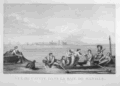 | Details | Duché de Vancy, Gaspard | 1797 |
| Vue de Cavite dans la Baie de Manille |
|
Duché de Vancy, Gaspard |
|
| 1797 |
| LOC:55 |
| $250.00 | Duché-de-Vancy--Gaspard | Vue-de-Cavite-dans-la-Baie-de-Manille | Engraved view of two boats and passengers with Cavite Philippines in the background as it was seen from Manilla Bay in January 1787.<BR> </BR>
Drawn by Gaspard Duchè de Vancy, a French artist of the 18th century. From the "Atlas du Voyage de La Perouse" published by Jean-Francois La Perouse. La Perouse led a scientific exploration to the Pacific from 1785, accompanied by Duchè de Vancy, and sent the drawing on which this engraving is based to France in 1788 with the intention of returning home by 1789. Departing Botany Bay, Australia in March, 1788 neither La Perouse, his ships the Boussole or Astrolabe, nor his men were ever seen again. Number 41.<BR> </BR>
Believe the engraving is an early 20th century re-strike from the original copper plate produced by the French Chalcographie du Louvre. La Chalcographie du Louvre is a repository of more that 13,000 original plates from the Louvre's archives, housed upstairs above the Louvre's Paris galleries . Upon request visitors can have a engraving produced on museum-quality paper from the original plate by a master printer. V.27 <BR> </BR> |
| 1182 | 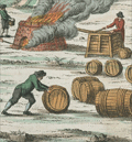 | Details | Wilhelm, Gottlieb Tobias | 1808 |
| Antique engravings of whaling and walrus hunting. |
|
Wilhelm, Gottlieb Tobias |
|
| 1808 |
| LOC:0 |
| $150.00 | Wilhelm--Gottlieb-Tobias | Antique-engravings-of-whaling-and-walrus-hunting- | A group of two antique copper-plate engraved pages containing scenes that show how mariners have exploited the aquatic environment for food or for the acquisition of wealth.
<br></br>
The upper print depicts a shore-based whale butchery and oil rendering location. In the foreground workers strip blubber from the dead whale lying in the shallows; a large fire burns nearby where the blubber would be boiled down to oil. Workers tend the fire and fill numerous wooden barrels with the whale oil, and at the end of the scene horse and wagon are shown to suggest the transfer of the oil barrels to another location.
<br></br>
The lower plate depicts a ships crew in a small rowboat firing upon a herd of walrus. While some of the crew fires their long guns other crew members use their oars to maintain the boats position and steady the rocking boat.
<br></br>
From G. T. Wilhelm's Encyclopedia of Natural History: Mankind. Augsburg, 1804. Gottlieb Tobias Wilhelm (1758-1811) was a Bavarian clergyman and naturalist known as the German Buffon |
| 1183 |  | Details | Wilhelm, Gottlieb Tobias | 1808 |
| Antique copper-plate engravings of whales |
|
Wilhelm, Gottlieb Tobias |
|
| 1808 |
| LOC:0 |
| $150.00 | Wilhelm--Gottlieb-Tobias | Antique-copper-plate-engravings-of-whales | A group of two antique copper-plate engraved pages containing charming depictions of several species of whales. These species are noted in manuscript on the page near each whale.
<br></br>
From G. T. Wilhelm's Encyclopedia of Natural History: Mankind. Augsburg, 1804. Gottlieb Tobias Wilhelm (1758-1811) was a Bavarian clergyman and naturalist known as the German Buffon |
| 889 | 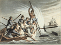 | Details | Clark, John Heaviside | 1813 |
| Antique aquatint of Killing a Shark |
|
Clark, John Heaviside |
|
| 1813 |
| LOC:1 |
| $95.00 | Clark--John-Heaviside | Antique-aquatint-of-Killing-a-Shark | First edition of this scarce hand-colored aquatint by <b>John Heaviside Clark</b> (1771-1836) in "Foreign Field Sports, Fisheries, Sporting Anecdotes…". In this fine engraved print from 1813 a small boat, overloaded with ship's crew pull a sailor to safety while another sailor prepares to drive a lance through the head of the shark.
<br></br>
A short shark-catching anecdote describes the physiology and habits of the shark and then devotes most emphasis to the shark's terrifying appearance and ferocity, concluding with this story:
<div class="indenttextblock"> "The late Sir Brook Watson was, as is well known, rescued from the jaws of death at the very moment when they were extended to devour him. His situation was precisely similar to that of the young seaman represented in the Plate. While bathing, when a young man, he was pursued by a Shark; and his imminent danger being perceived by the ships company, a boat was immediately put off: before it arrived, however the Shark had snapped at its unfortunate victim, and carried off a leg and a part of the thigh. It was in the act of making a second seizure when a sailor struck it with a boat-hook, and drove it from the pursuit.
</div>
</br>
Published by Edward Orme from Bond Street London, on March 1, 1813. On paper bearing a watermark of 1811. |
| 890 | 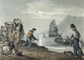 | Details | Clark, John Heaviside | 1813 |
| Antique aquatint of Turtle Catching on Land |
|
Clark, John Heaviside |
|
| 1813 |
| LOC:1 |
| $145.00 | Clark--John-Heaviside | Antique-aquatint-of-Turtle-Catching-on-Land | First edition of this scarce hand-colored aquatint from 1813 by <b>John Heaviside Clark</b> (1771-1836) in "Foreign Field Sports, Fisheries, Sporting Anecdotes…". In this fine engraved print a ship's crew loads large <b>sea turtles</b> aboard a small boat in order to bring them to their waiting ship. On long voyages fresh meat could run out aboard ship so these turtles would have provided a valuable source of nourishment. In addition, the turtles could be kept alive until needed, solving the problem of maintaining a fresh supply of food in an era without refrigeration.
<br></br>
In an anecdote accompanying the plate, the author explains how the turtles are caught:
<div class="indenttextblock"> "The turtle catchers, from the month of September to January, repair to those parts of the coast which the turtles mostly frequent, and watch them on shore, where they deposit their eggs in the night-time. The usual way is, to turn them quickly on their backs, not giving them time to defend themselves, by throwing up sand with their fins; which they can do with such force as sometimes to blind their assailants. … When the turtles find it impossible to escape, they utter a sort of sigh and are said to shed tears."
</div>
</br>
Published by Edward Orme from Bond Street London, on July 1, 1813. A very similar plate to this one, purchased at the same time bears a watermark of 1811. |
| 644 | 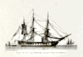 | Details | Baugean, Jean-Jerome | 1814 |
| American Frigate at Anchor |
|
Baugean, Jean-Jerome |
|
| 1814 |
| LOC:1 |
| $225.00 | Baugean--Jean-Jerome | American-Frigate-at-Anchor | Attractive and scarce original nautical antique copperplate engraving of an American frigate by the French artist Jean-Jerome Baugean. Published circa 1814 the small plate shows an American frigate at anchor. According to John Harland: <dir class="indenttextblock">"The mizzen topsail is set, and the wind-sail just seen abaft the fore mast was used in hot weather to ventiilate the gundeck; the crew have washed their hammocks, and these have been triced up to dry… This is one of the smaller frigates, possibly the Boston." (Harland, John. "The Maritime Prints of J.J. Baugean", Chatham Publishing. London, 2000. p. 40.) </dir>
</BR>
This antique engraving is from a series of 72 fine engravings of merchant and naval vessels created and engraved by Baugean (1764-1830) in the series: "Collection de Toutes les Especes de Batimens de Guerre et de Batimens Marchard." Baugeans engravings are notable for their accurate and detailed depictions of ship construction and rigging. |
| 645 | 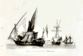 | Details | Baugean, Jean-Jerome | 1814 |
| French Mediterranean Privateers |
|
Baugean, Jean-Jerome |
|
| 1814 |
| LOC:1 |
| $195.00 | Baugean--Jean-Jerome | French-Mediterranean-Privateers | Original antique nautical copper-plate engraving of three French privateer ( corsair ) vessels. Published circa 1814 by Jean-Jerome Baugean this authentic small plate shows three Mediterranean privateers at anchor. According to John Harland: <dir class="indenttextblock">"Baugean does not comment on the rigs, but from right to left they are a schooner, tartane, and what seems to be an armed pinque. The last is airing both its lateen and square sails. This ensemble emphasizes the fact that although northern European rigs, like the schooner, were to be found in the Mediterranean, there were a number of rigs - and indeed hull forms - unique to that sea." (Harland, John. "The Maritime Prints of J.J. Baugean", Chatham Publishing. London, 2000. p. 98.) </dir>
</BR>
This antique engraving is from a series of 72 fine engravings of merchant and naval vessels created and engraved by Baugean (1764-1830) in the series: "Collection de Toutes les Especes de Batimens de Guerre et de Batimens Marchard." Baugean's engravings are notable for their accurate and detailed depictions of ship construction and rigging. |
| 320 | 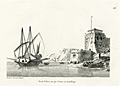 | Details | Baugean, Jean-Jerome | 1814 |
| Demi Galere, vue par l'avant , au mouillage |
|
Baugean, Jean-Jerome |
|
| 1814 |
| LOC:1 |
| $225.00 | Baugean--Jean-Jerome | Demi-Galere--vue-par-l-avant---au-mouillage | This small, highly-detailed antique copperplate engraving by the French artist Jean-Jerome Baugean published circa 1814 details a demi-galère (small galley) at anchor. The demi-galere pictured carried 5 cannon, mounted at the bow and about 9 oars on each side. A full-sized galley might be armed with a dozen or more cannon and be fitted with banks of 24 oars to both port and starboard.
<BR> </BR>
This demi galere is noteworthy because of the three masts with lateen sails. The additional mizzen near the stern would have increased the vessel's maneuverability.
<BR> </BR>
This engraving is from a series of 72 fine engravings of merchant and naval vessels created and engraved by Baugean (1764-1830) in the series: "Collection de Toutes les Especes de Batimens de Guerre et de Batimens Marchard." Baugean's engravings are notable for their accurate and detailed depictions of ship construction and rigging. |
| 290 | 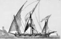 | Details | Baugean, Jean-Jerome | 1814 |
| Chebec espagnol a voiles latines, courant vent largue. |
|
Baugean, Jean-Jerome |
|
| 1814 |
| LOC:0 |
| $150.00 | Baugean--Jean-Jerome | Chebec-espagnol-a-voiles-latines--courant-vent-largue- | This item would make an exceptional gift for a loved one !
<br><br>
Below please find a sweet original antique copperplate engraving with very fine detail printed in 1814. A superlative example by the French artist Jean-Jerome Baugean on creamy laid with a tight platemark as was the practice. Published circa 1814 the engraving shows a Chebec (alt. 'zebec') underway in a light breeze.
<br><br>
Xebec's are small vessels similar in size to a frigate and characterized by 2 or 3 lateen sails and a prominent overhanging bow and stern.
<br><br>
This engraving is from a series of 72 fine antique engravings of merchant and naval vessels created and engraved by Baugean (1764-1830)- "Collection de Toutes les Especes de Batimens de Guerre et de Batimens Marchard." Baugean's engravings are notable for their accuracy and detail. |
| 291 | 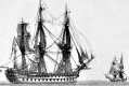 | Details | Baugean, Jean-Jerome | 1814 |
| Vaisseau de Ligne Francais, au Plus Pres du vent, le Perroquet de Fougue Sur le Mat |
|
Baugean, Jean-Jerome |
|
| 1814 |
| LOC:1 |
| $185.00 | Baugean--Jean-Jerome | Vaisseau-de-Ligne-Francais--au-Plus-Pres-du-vent--le-Perroquet-de-Fougue-Sur-le-Mat | This small, highly-detailed antique copperplate engraved print by the French artist Jean-Jerome Baugean published circa 1814 details a French ship-of-the-line close to the wind. <BR> </BR>
This engraving is from a series of 72 fine antique prints of merchant and naval vessels created and engraved by Baugean (1764-1830)- "Collection de Toutes les Especes de Batimens de Guerre et de Batimens Marchard." Baugean's engravings are notable for their accuracy and detail. |
| 295 | 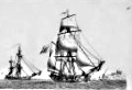 | Details | Baugean, Jean-Jerome | 1814 |
| Bombardes Francaises de la Mediterranee |
|
Baugean, Jean-Jerome |
|
| 1814 |
| LOC:1 |
| $175.00 | Baugean--Jean-Jerome | Bombardes-Francaises-de-la-Mediterranee | This antique, small, highly-detailed copperplate engraving by the French artist Jean-Jerome Baugean published circa 1814 details two French bombardes (or bomb-vessels) at sea. A bombarde relied on mortars mounted near the bow with high elevation to lob exploding shells down on the enemy. Early French bomb-vessels had two mortars placed side-by-side in the bow that were aimed while at anchor by pulling in or letting out a spring anchor. The heavy armament explains the wide and somewhat barge-like bow depicted in this engraving. The extra width would have been needed to support the weight of the mortars.<BR> </BR>
This engraving is from a series of 72 fine antique prints of merchant and naval vessels created and engraved by Baugean (1764-1830) in the series: "Collection de Toutes les Especes de Batimens de Guerre et de Batimens Marchard." Baugean's engravings are notable for their accurate and detailed depictions of ship construction and rigging. |
| 325 | 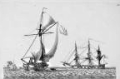 | Details | Baugean, Jean-Jerome | 1814 |
| Sloop vu par l'avant; Prame venant de mouiller |
|
Baugean, Jean-Jerome |
|
| 1814 |
| LOC:1 |
| $125.00 | Baugean--Jean-Jerome | Sloop-vu-par-l-avant;--Prame-venant-de-mouiller | "Sloop vu par 'l'avant" is a highly-detailed nautical antique copperplate engraving by the French artist Jean-Jerome Baugean. Published circa 1814 the small plate shows a sloop from the bow under full sail after it has passed a pram at anchor (Fr. Prame). In this context the pram is a large 3-masted flat bottom ship with about 10 cannon.<BR> </BR>
This antique engraving is from a series of 72 fine engravings of merchant and naval vessels created and engraved by Baugean (1764-1830) in the series: "Collection de Toutes les Especes de Batimens de Guerre et de Batimens Marchard." Baugean's engravings are notable for their accurate and detailed depictions of ship construction and rigging. |
| 6721 |  | Details | Yeager, Joseph | 1817 |
| Battle of New Orleans Engraving Death Packenham |
|
Yeager, Joseph |
|
| 1817 |
| LOC:86 |
| $1,200.00 | Yeager--Joseph | Battle-of-New-Orleans-Engraving-Death-Packenham | This engraved copper-plate print, created in 1817 by Joseph Yeager after William Edward West, depicts the decisive moment in American history when Major General Andrew Jackson led United States forces to a victory over the British Army and Royal Navy near Chalmette, Louisiana in the Battle of New Orleans. This significant triumph marked a turning point in the War of 1812.
<br><br>
The print vividly portrays the intensity and drama of the battle, capturing the heroic victory of the American soldiers over the invading British forces. General Edward Pakenham's death signified the end of the battle.
<br><br>
The print shows the British forces as they advance upon the American earthworks or barricades, which were fiercely defended by Jackson's forces. At the bottom center, a head-and-shoulders portrait of Andrew Jackson, along with American flags and weapons.
<br><br>
Second state issue of the print includes thirteen lettered keys lacking in the first, and also features the figure of Gen. Lambert pointing to the right. In the first state, Lambert is depicted weeping into a handkerchief.
<br><br>
Copper engraving. Printed by Yerkes Saurman (1791- )
<br><br> |
| 409 | 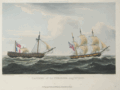 | Details | Ralfe, James | 1820 |
| Capture of La Furieuse |
|
Ralfe, James |
|
| 1820 |
| LOC:0 |
| $190.00 | Ralfe--James | Capture-of-La-Furieuse | Depicts the British vessel Bonne Citoyenne towing the Furieuse after defeating her in an eight hour battle. Hand-colored aquatint engraving from James Ralfe's 'The Naval Chronology of Great Britain'. Matted and framed.
<BR> </BR>
Attribution line: "Pub'd. By Pyall & Stroud, 19 Hanway Street Oxford Street." On wove paper with watermark "1825". |
| 415 | 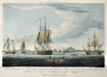 | Details | Ralfe, James | 1820 |
| The Prometheus and Melpomene |
|
Ralfe, James |
|
| 1820 |
| LOC:0 |
| $190.00 | Ralfe--James | The-Prometheus-and-Melpomene | Matted and framed.
<BR> </BR>
Antique hand-colored aquatint engraving depicts the day following a battle in which the Melpomene, Implacable, Bellerophon, and Prometheus captured six Russian gunboats and 12 supply vessels near Percola Point, Frederikshavn, Denmark.<BR> </BR>
From James Ralfe's 'The Naval Chronology of Great Britain'. Attribution line: "Pub'd. By Pyall & Stroud, 19 Hanway Street Oxford Street." On wove paper . |
| 418 | 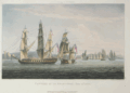 | Details | Ralfe, James | 1820 |
| Capture of La Sparviere, May 3rd 1810. |
|
Ralfe, James |
|
| 1820 |
| LOC:0 |
| $190.00 | Ralfe--James | Capture-of-La-Sparviere--May-3rd-1810- | Hand-colored aquatint engraving depicts the British 46-gun Spartan capturing the French vessel Sparviere in the Bay of Naples in 1810.<BR> </BR>
From James Ralfe's 'The Naval Chronology of Great Britain'. Attribution line: "Pub'd. By Pyall & Stroud, 19 Hanway Street Oxford Street." On wove paper . |
| 6490 | 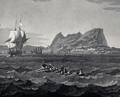 | Details | Hegi, Franz | 1830 |
| Aquatint view of Gibraltar as seen from offshore |
|
Hegi, Franz |
|
| 1830 |
| LOC:86 |
| $300.00 | Hegi--Franz | Aquatint-view-of-Gibraltar-as-seen-from-offshore | Acquaint engraved view of Gibraltar in 1830 as seen from offshore by Franz Hegi (1774 - 1850). B&W on wove paper. 22" x 17" within the platemark.
<br><br>
French credits at bottom: "Peint par Noël, Gravé par Fr. Hegi. Imprimé par Schweizer, à Paris chez M. Bance ainé rue St. Denis No.214. |
| 508 |  | Details | Cruikshank, George | 1835 |
| The Sailors Progress |
|
Cruikshank, George |
|
| 1835 |
| LOC:9 |
| $165.00 | Cruikshank--George | The-Sailors-Progress | Naval-themed frontispiece to a series of eight British naval caricature engravings by George Cruikshank depicting the life of Master Blockhead. Copperplate etching published by Thomas McLean, 26 Haymarket, London. August 1, 1835. Printed on an 11"x17" sheet of heavy wove paper the etching measure 5" by 7". |
| 391 | 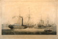 | Details | Huggins, W.J. | 1842 |
| Ships of the General Steam Navigation Company, Off Rotterdam. |
|
Huggins, W.J. |
|
| 1842 |
| LOC:0 |
| $600.00 | Huggins--W-J- | Ships-of-the-General-Steam-Navigation-Company--Off-Rotterdam- | Hand-colored aquatint by William John Huggins from 1842 of the steamers Giraffe and Ocean in Rotterdam Harbor. In the foreground a small boat is shown ferrying passengers dressed in Dutch clothing of that era. <BR> </BR>
The steam side-wheelers Giraffe and Ocean were both launched in 1836 and operated as mail steamers for the General Steam Navigation Company (GSNC) . Not the Robert E. Lee ( ex Giraffe), a Civil War Confederate blockade runner built in 1862 with twin stacks.
<BR> </BR>
The GSNC was founded in 1824 in Greenwich, England. For 150 years the firm was London's top short-sea shipping service with routes between the ports of Britain and north west Europe.
<BR> </BR>
Attribution line below the print reads: "Painted by W.J. Huggins, marine painter to his late majesty William IV. London. Published by Mr. Huggins 105 Leadenhall Street. 1842. Engraved by E. Duncan." |
| 4739 | 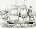 | Details | Barbey, Isidore-Théodore | 1845 |
| Very rare broadsheet. Barbey clipper-ship advertisement. Havre, France |
|
Barbey, Isidore-Théodore |
|
| 1845 |
| LOC:62 |
| $3,500.00 | Barbey--Isidore-Théodore | Very-rare-broadsheet--Barbey-clipper-ship-advertisement--Havre--France | Very rare and historical clipper-ship advertisement for ships (Paquebots / Clippers) owned by <b>Isidore-Théodore Barbey</b> of Havre, France. Barbey's ships were known for their <b>white hulls</b>. This important broadsheet likely dates to the earliest shipping enterprise owned by Barbey, before incorporation in 1855. Not found online. Lithographed by Lenormand, Rue de l'Hopital 37, Havre.
<br></br>
The goal of the advertisement was to convey the luxuriousness of traveling on Barbey's ships by including a detailed plan for the Grande Chambre with tiny four-person staterooms and a single watercloset for all passengers. Housed below the "dunette", a high, exposed deck at the stern of the ship, was an antechamber, an office, dining table and cabins for two captains, and 30 passengers. For reference to key points in the ship's construction the lithograph shows the location for the mizzen mast (mat d'artimon) and the rudder post (gouvernail).
<br></br>
<div class="indenttextblock">
In 1839 Isidore-Théodore Barbey founded in Le Havre a shipping company for trade with Valparaíso and Lima. The company prospered, with six ships in 1850, and was incorporated as <b>Compagnie d'Armement Maritime in 1855</b>. Passenger ships operated on scheduled lines from Le Havre to Valparaíso, Vera Cruz, La Plata, Bahia and Reunion. The magnificent, white-hulled ships were nicknamed "white clippers". The shipowner never insured his ships and reinvested the saved premiums [likely the reason the ship does not appear in Lloyd's extensive records]. In 1857, Barbey owned 39 vessels and had another 34 in construction.</div></BR>
<img src="/PageImages/Barbey_Flag.jpg" alt="Barbey clipper-ship house flag." width="100" border="2" hspace="10" vspace="10" align="middle"> Barbey flag: White with black letters.
<br></br>
(Source: Flags of the World. https://fotw.info/flags/fr~hfarm.html") |
| 6460 | 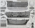 | Details | Heck, Georg | 1849 |
| Antique plans for a three-decked warship ship-of-the-line. |
|
Heck, Georg |
|
| 1849 |
| LOC:78 |
| $140.00 | Heck--Georg | Antique-plans-for-a-three-decked-warship-ship-of-the-line- | Original, antique maritime architectural views of a large three-deck ship-of-the-line. This antique print is full of nautical renderings including a plan of the hull contour; an elevation view showing side framing; a cutaway showing bottom-deck framing plan; a stowage plan view; and numerous smaller details related to naval architecture.
<br><br>Steel-plate engraving. |
| 1045 |  | Details | Zawitz, Verlag v.w. | 1850 |
| Lithograph of the British warship Wellington |
|
Zawitz, Verlag v.w. |
|
| 1850 |
| LOC:1 |
| $375.00 | Zawitz--Verlag-v-w- | Lithograph-of-the-British-warship-Wellington | Attractive German lithograph of the 3-decked 74-gunBritish ship of the line "HMS Wellington" with auxiliary steam power. Published by Verlag v.w. Zawitz in Berlin ca. 1850. |
| 6459 | 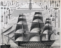 | Details | Heck, Georg | 1851 |
| 19th-century engraving sailing ship and rigging |
|
Heck, Georg |
|
| 1851 |
| LOC:78 |
| $140.00 | Heck--Georg | 19th-century-engraving-sailing-ship-and-rigging | Steel-plate line engraving depicting a triple-decked ship-of-the-line and some of the rigging and equipment with special emphasis on blocks, tackle, and armament. From Georg Heck's "Iconographic Encyclopedia" published by Rudolph Garrigue in New York in 1851. Cool! |
| 473 |  | Details | Gillray, James | 1851 |
| End of the Irish Invasion |
|
Gillray, James |
|
| 1851 |
| LOC:9 |
| $195.00 | Gillray--James | End-of-the-Irish-Invasion | Re-strike satirical copperplate engraving from the original plate by one of England's finest 18th century artists and satirists, James Gillray. This engraving by James Gillray reflects the fear of invasion from France at the end of the 18th century, just a few years after the French revolution. The prospect of invasion by sea has threatened the British Isles several times beginning in Roman times, notably during the "Invincible Armada" sent by Spain in 1588. <BR> </BR>
The New York Public Library website explains the plate: <dir class="indenttextblock">"From the beginning of the conflict with France, the British feared a French invasion. In October 1796, the King warned against such a threat, which was dismissed by the Opposition as a fantasy. However, on December 15, 1796, a French force of 15,000 troops with an armada of ships, led by General Lazare Hoche, sailed from Brest and anchored in Bantry Bay off southern Ireland, assuming that their invasion would prompt a popular uprising against the British. Like the Spanish Armada two hundred years before, this plan was undone primarily by stormy weather. The winds in Gillray’s version emanate from (left to right) the mouths of Prime Minister Pitt, Secretary of War Henry Dundas, Foreign Secretary William Wyndham Grenville, and War Minister William Windham. One ship, Le Révolutionare with a Fox figurehead, is tossed by wind and waves, the L’Egalité is swamped, and the Whigs aboard The Revolutionary Jolly Boat appear doomed."</dir>
<BR>
Source: New York Public Library. Print Collection. No. 49.<BR> </BR>
Originally published in 1797 by Hannah Humphrey this plate is from the Henry Bohn restrikes printed from the original plates during 1845 to 1851. Printed on both sides of heavy wove paper, the other side contains another fine engraving by Gillray titled "The Lion's Share". |
| 474 |  | Details | Gillray, James | 1851 |
| The Hero of the Nile |
|
Gillray, James |
|
| 1851 |
| LOC:9 |
| $245.00 | Gillray--James | The-Hero-of-the-Nile | Re-strike caricature copperplate engraving from the original plate, by one of England's finest 18th century artists and satirists, James Gillray. Gillray's topic in this plate, first published in 1798, is one of Britain's naval heroes, Admiral Horatio Nelson (1758-1805). <BR> </BR>
Today, without an explanation many readers would not realize that this engraving is a caricature of Nelson, generally considered to be a great naval leader. The Greenwich Royal Museum explains Gillray's point of view:<i> " In contrast to other unquestioningly adulatory prints of Nelson’s victory at the Battle of the Nile, Gillray here sardonically points to the very large material rewards heaped upon Nelson as a result. Burlesquing the genre of heroic portraiture, he presents Nelson in solitary full-length, on deck and enveloped in smoke. Gillray draws attention to the diamond chelengk in Nelson’s hat, presented to him by the Sultan of Turkey, and in the adapted coat of arms below the main image satirizes his recent baronetcy. In November Nelson was created Baron Nelson of the Nile and Burnham Thorpe and was awarded a pension of £2000 a year. Gillray substitutes for the correct arms on the original shield a bulging purse and scroll inscribed ‘£2000 pr Ann’. Placed alongside Nelson’s motto ‘Palmam qui meruit ferat’ (Let he who has earned it bear the Palm), Gillray undermines the motto’s meaning, to question whether such a large material reward really is merited.</i><BR>
Source: National Maritime Museum, Greenwich, London. Collections.
<BR> </BR>
Originally published in 1798 this plate is a restrike by Henry Bohn printed from the original plates during 1845 to 1851. Printed on both sides of heavy wove paper, the other side contains another engraving, a biting satire by Gillray titled "Destruction of the French Collossus". Plate 211. |
| 475 |  | Details | Gillray, James | 1851 |
| St. George and the Dragon |
|
Gillray, James |
|
| 1851 |
| LOC:9 |
| $500.00 | Gillray--James | St--George-and-the-Dragon | Spectacular re-strike caricature copperplate engraving from the original plate, by one of England's finest 18th century artists and satirists, James Gillray. The quality of engraving and the dark impression, along with Gillray's composition, and large size make this a very striking and attractive work. <BR> </BR>
The scene depicts the royal St. George (King George III) rescuing Britannia from the fangs of the Monster of France (Napoleon). The king wears the uniform of his own regiment of Guards (the Blues). <BR>
Source: Wright, Thomas and Robert Harding. "Historical and Descriptive Account of the Caricatures of James Gillray" Google Books. P.242 <BR> </BR>
Originally published in 1805 this plate is a restrike by Henry Bohn printed from the original plates during 1845 to 1851. Printed on both sides of heavy wove paper, the other side contains another engraving, a satire by Gillray titled "The end of the farce of Catholic Emancipation". |
| 1105 | 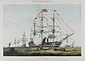 | Details | Illustrated London News | 1856 |
| The James Watt Man of War |
|
Illustrated London News |
|
| 1856 |
| LOC:9 |
| $145.00 | Illustrated-London-News | The-James-Watt-Man-of-War | Colorful lithograph of the twin decked ship-of-the line James Watt, a sail and steam powered vessel. In celebration of the queen's birthday sailors man the yards and cannons are fired in salute. Published by the Illustrated London News July 26, 1856. |
| 6362 | 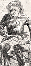 | Details | Stephen, Louis H. | 1862 |
| Civil War era satirical cartoon related to secession and loyalty |
|
Stephen, Louis H. |
|
| 1862 |
| LOC:1 |
| $50.00 | Stephen--Louis-H- | Civil-War-era-satirical-cartoon-related-to-secession-and-loyalty | Civil War era satirical cartoon related to secession and loyalty. Lampoons politically well-connected but inept John Floyd, considered to have been a traitor to the Union (1).
<br></br>
<br>
<div class="indenttextblocksingle">
<ul style="list-style-type: none;">
<div style="text-align: Left;font-size:125%;font-weight: bold;">An Old Friend, With a New Face
</div>
<br>
<br>
<li>Aesop tells of a man who drained.</li>
<li>His cup of avarice to the dregs;</li>
<li>Staked what he had to what he wished,</li>
<li>And lost his golden eggs.</li>
<br>
<li>Thus rashly acts the ambitious south,</li>
<li>In discontent without excuse;</li>
<li>Take warning and mind that ye </li>
<li>ARE SOUND UPON THE GOOSE.</li>
</ul>
</div>
<br></br>
(1) John Buchanan Floyd (1806 – 1863) 31st Governor of Virginia, U.S. Secretary of War, and Confederate general in the Civil War. Floyd lost the Battle of Fort Donelson. |
| 1203 | 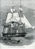 | Details | Illustrated London News | 1863 |
| Steam Corvette Racoon 22 Guns |
|
Illustrated London News |
|
| 1863 |
| LOC:0 |
| $130.00 | Illustrated-London-News | Steam-Corvette-Racoon-22-Guns | Fine wood engraving of the British Steam Corvette Racoon, 22 Guns. From the Illustrated London News published from London in 1863, during the hostilities to the west of the U.S. Civil War.
<br></br> Would frame nicely and present as a fine, thoughtful gift.
<br></br>
<div class="indenttextblock"> "Wood engraving is a printmaking and letterpress printing technique, in which an artist works an image or matrix of images into a block of wood. Functionally a variety of woodcut, it uses relief printing, where the artist applies ink to the face of the block and prints using relatively low pressure. By contrast, ordinary engraving, like etching, uses a metal plate for the matrix, and is printed by the intaglio method, where the ink fills the valleys, the removed areas. As a result, wood engravings deteriorate less quickly than copper-plate engravings, and have a distinctive white-on-black character." (Source: <a href="https://en.wikipedia.org/wiki/Wood_engraving" target="_blank">INTERNET</a> )
</div> |
| 1410 | 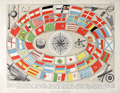 | Details | Brockhaus, F.A. | 1870 |
| Flaggenkarte or Naval Flags |
|
Brockhaus, F.A. |
|
| 1870 |
| LOC:0 |
| $99.00 | Brockhaus--F-A- | Flaggenkarte-or-Naval-Flags | Attractive German lithograph ca. 1870 of naval flags and ensigns titled "Seewesen". Shown with nautical and navigational artifacts including a sounding lead (60). As is typical on antique sounding leads, the center was left hollow to receive a soft piece of wax or tallow. The wax would pick up sediment (rocks, sand, silt) from the bottom enabling the navigator to possess simultaneous knowledge of another variable in addition to water depth.
<BR> </BR>
Together water depth and bottom composition helped provide a more accurate estimate of a ship's position. Sailing directions for hundred of years were likely to carry information about the sea floor such as "When the big rock is about 1/2 mile distant off your port beam and you find 20 fathoms of water and sandy bottom you are appproaching the rivers' mouth. Be sure to keep at least 6 fathoms and beware stony bottom at edges of channel."
<BR> </BR>
Other instruments include a compass, taffrail log, sextant, speaking trumpet and barometer.
<BR> </BR>
Attribution at bottom beneath mat reads : "Druck und verlag von F.A.Brockhaus in Leipzig". Archivally matted. Total size with mat is 17" W x 14" H. Sheet |
| 505 | 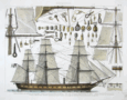 | Details | Brockhaus, F.A. | 1870 |
| Seewesen (Sailing Ship with Rigging) |
|
Brockhaus, F.A. |
|
| 1870 |
| LOC:1 |
| $190.00 | Brockhaus--F-A- | Seewesen-(Sailing-Ship-with-Rigging) | Original antique steel engraving of a 19th sailing ship and its rigging. Ship dates to the early period when ships converted from sail to steam- a single smokestack is visible amidships. Details of numerous ship's blocks, sails, spars, and nautical knots. Plate 12. Leipzig, Germany. |
| 4804 |  | Details | U.S. Coast and Geodetic Survey | 1894 |
| Antique MS engineering drawing of screw-pile day-mark beacon |
|
U.S. Coast and Geodetic Survey |
|
| 1894 |
| LOC:55 |
| $450.00 | U-S--Coast-and-Geodetic-Survey | Antique-MS-engineering-drawing-of-screw-pile-day-mark-beacon | Fine late 19th-century manuscript engineering drawings of a screw-pile day-beacon designed for the Tobago Middle Ground shoal in the Rappahannock River, Virginia. Probably a product of the U.S. Coast and Geodetic Survey. Dated within to 1894. Baltimore, Maryland.
<br></br>
Manuscript pencil notations: "Not used" and "Historical".
<br></br>
In a 1896 letter to Congress transmitting estimates of appropriations from the Secretary of the Treasury is a line item for $3,000 for "Establishing a day beacon on or near the Tobago Middle Ground, Rappahannock River, Virginia." A note below the item states: "The middle ground has but four feet of water on it. A prominent mark would be a valuable aid in the navigation of that part of the river." Apparently this request derived from the Lighthouse Board who proposed to build a screw-pile beacon at Tobago as early as 1893.
<br></br>
Our drawing, from 1894, is annotated with the words "not used". That may very well be because a less expensive solution was adopted. According to the U.S. Coast and Geodetic Survey Notice to Mariners in 1903 "a black spar buoy, without number, was placed in 15 feet of water on the edge of the shoal opposite the upper end of Tobago Middle Ground." |
| 1072 |  | Details | George W. Walker Lithograph and Publishing Co | 1897 |
| 1897 Birds-eye View of Boston Harbor |
|
George W. Walker Lithograph and Publishing Co |
|
| 1897 |
| LOC:200 |
| $340.00 | George-W--Walker-Lithograph-and-Publishing-Co | 1897-Birds-eye-View-of-Boston-Harbor | Bird's-eye folding pocket map of Boston Harbor and surrounding region to the east. Numerous steamers and sailing ships are shown underway in the waters offshore Boston, Massachusetts; Winthrop and Squantum .
<br></br>
Very fine condition makes this a desirable addition to your collection. The map extends from the coastal area of East and South Boston across the water to the main ship channel and the Boston Light. It locates Winthrop, Thompson's Island, Moon Island, Deer Island, Nahant, Green Island, the Brewster Islands, Strawberry Hill, Fort Warren, Hough's Neck and much more. Several key steets are identified within Boston: Atlantic Avenue, Summer Street, Broadway, Dorchester Street, and State Street to name a few.
<br></br>
Copyright 1897 by George H. Walker and Company, Harcourt Street, Boston MA.. Shows steamer routes to Nantasket Beach, Nahant, Winthrop and more. On the inside cover is an list of railroad maps; a list of road maps is on the back.
<br></br>
Single-color chromolithograph. It folds into paper covers titled "Bird's-Eye View of Boston Harbor." Walker's maps were often sold as advertising maps under another name, most notably by the Union News Co. Map is attached to the cover as issued. |
| 604 |  | Details | Toshihide, Migita | 1900 |
| Russo-Japanese War Triptych |
|
Toshihide, Migita |
|
| 1900 |
| LOC:0 |
| $850.00 | Toshihide--Migita | Russo-Japanese-War-Triptych | Scarce Japanese nautical woodblock print from the Japanese artist Migita Toshihide (1863 - 1925) who is well known for his woodblock prints depicting both the Russo-Japanese war and the later Sino-Japanese war. This print (ca. 1900 ) depicts Japanese sailors on the deck of a sinking vessel struggling with a small boat as they are illuminated by a spotlight. Strong, stylized depiction of breaking waves. Rising sun in the background.
<br></br>
Matted and framed with a simple 1/2" molding for an overall size of approximately 33" W x 19" H. |
| 5174 |  | Details | Hettinger, C. F. | 1901 |
| Cyanotype blueprint floor plan for 1901 Boston Brew-master's convention |
|
Hettinger, C. F. |
|
| 1901 |
| LOC:62 |
| $550.00 | Hettinger--C--F- | Cyanotype-blueprint-floor-plan-for-1901-Boston-Brew-master-s-convention | Original one-of-a-kind cyanotype, or blueprint, floor plan for the 1901 Brew-Master's Convention to be held in the Massachusetts Charitable Mechanic Association Building, Boston Mass. The 13th annual convention of the <b>United States Brewmaster's Association</b> was held in Boston during the week beginning on September 23, 1901.
<br></br>
The plan distinguishes between two areas in the building- the Convention Hall and the Exhibition Hall. The Exhibition Hall was a new feature of the convention:
<div class="indenttextblocksingle">
"… it has been thought desirable to make special arrangements for facilities for demonstrating and exhibiting all classes of machines and supplies adapted to brewer's use …" [1]
</div>
</br>
The Charitable Mechanics Association built the Mechanic's Hall in 1881 on Huntington Avenue, at West Newton Street near Copley Square. Architect William Gibbons Preston designed the hall which featured an auditorium, sometimes referred to as the Grand Hall. The hall was demolished in 1958.
<br></br>
Drawn and printed by C. F. Hettinger & Co. Engineers & Architects. 1140 Columbus Ave. Boston, Mass.
<br></br>
[1] Online: Gindele, William J. American Brewers' Review. Wahl and Henius eds. 1900-1901. p.282.
<br></br>
(beer, brewing, brew, craft beer, brewery, hops, tipsy, hopped up, loaded, drunk, shit-faced, sdfngd) |
| 5136 |  | Details | Seaboard Air Line Railway | 1904 |
| Antique Panoramic View of Havana Cuba |
|
Seaboard Air Line Railway |
|
| 1904 |
| LOC:51 |
| $550.00 | Seaboard-Air-Line-Railway | Antique-Panoramic-View-of-Havana-Cuba | Antique folding half-tone panoramic view of Havana, Cuba (1904) titled "Havana Harbor and City." A very fine view from a brochure by the Seaboard Air Line Railway "Cuba" promoting the route of the Peninsular and Occidental Steamship Company's steamship from Port Tampa to Key West, Florida to Havana.
<br></br>
A drawing, resembling a photograph, showing a panoramic view taken from the perspective of La Cabaña, (Fortaleza de San Carlos de la Cabaña). At upper right the view shows Morro Castle and lighthouse at the entrance to Havana Bay. Across the bay, the city of Havana shines, while sailing vessels and steam powered ships ply the waters of the bay. A reviewer of the period described the work as:
<div class="indenttextblocksingle">
<ul style="list-style-type: circle;">
… a panoramic view of Havana Harbor and City superbly reproduced in half-tone, the sky and water effects being especially meritorious, showing skillful overlay and press-work." [1].
</ul>
</div>
Brochure printed by Edgell Press. Cover to brochure included.
<BR></BR>
[1] Ryan, Charles B. Transportation. January 1904. No. 1. p. 29. |
| 639 |  | Details | Montaut, Ernest | 1909 |
| First Crossing of the English Channel by Air |
|
Montaut, Ernest |
|
| 1909 |
| LOC:0 |
| $875.00 | Montaut--Ernest | First-Crossing-of-the-English-Channel-by-Air | Original handcolored pochoir-process lithographed poster by Ernest Montaut commemorating the first crossing of the English Channel by a heavier-than-air aircraft in July 1909 by French aviator and engineer Louis Charles Joseph Blériot. The flight lasted less than 37 minutes. Bleriot won a prize of £1,000 for his achievement from the Daily Mail newspaper. Very good condition.
<br><br/>
Published by Mabileau, Paris. Copyright 1909.
<br><br/>
The 'pochoir' process used to color the lithograph is defined as: "French for 'stencil', used of prints coloured by hand with the help of stencils to mask out the areas where each colour is not required". (Gascoigne, Bamber. "How to Identify Prints. Thames and Hudson, 1991. Page 206. ) |
| 6503 |  | Details | Peninsular and Oriental Shipping Co. | 1910 |
| P and O Pleasure Mediterranean Cruises Handbill for 1910 |
|
Peninsular and Oriental Shipping Co. |
|
| 1910 |
| LOC:78 |
| $120.00 | Peninsular-and-Oriental-Shipping-Co- | P-and-O-Pleasure-Mediterranean-Cruises-Handbill-for-1910 | Small strikingly vivid, original lithographed handbill for Mediterranean cruises with the ships of London-based Peninsular and Oriental (P&O) Steam Navigation Company in 1910. Twin inset schedules with details and dates of cruises aboard the Mantua and the Vectis two of P&O's eight new steamers of the "M" class. Text on verso.
<br><br>
A very attractive and colorful chromolithograph related to Mediterranean tourism at the beginning of the twentieth century. |
| 6429 |  | Details | Holmes, Bradford Butterick | 1911 |
| Four cyanotype sketches for a concealed five shot revolver |
|
Holmes, Bradford Butterick |
|
| 1911 |
| LOC:300 |
| $380.00 | Holmes--Bradford-Butterick | Four-cyanotype-sketches-for-a-concealed-five-shot-revolver | Set of four original antique cyanotype or blueprint inventor's sketches for a concealable revolver. The revolver was designed by Bradford Butterick Holmes in 1911. In December, 1912 Holmes was granted US patent #1,047,054 on the revolver. It was Bradford Holmes' first patent, but not his last.
<br><br>
<div id="1" align="center">
<a title="Holmes' Revolver."></a>
<img id="1" src="/ZoomifyImages/SC_6429/SC_6429_400x300.jpg" alt="" width="250"/> <br><small>Fig. 1. Holmes concealed revolver</small>
</div><br>
The first sheet of four (Fig. 1.) shows an actual size depiction of the revolver concealed within the user's fist, only the short barrel extending beyond the fingers of a hand stretched from a cuff-linked shirt. Sheets 2, 3, and 4 are double size renderings of the revolver's mechanical details. The sketches are dated October 11, 1911 and witnessed by Ruth Vickery Holmes (Bradford's wife) and Hilma Christenson.
<br><br>
In 1903 Bradford Butterick Holmes is recorded as a first year student at the Massachusetts Institute of Technology with his home town listed as Mare Island, California. Apparently Bradford Holmes wed Ruth in May 1909 and together they had two children, Elizabeth and Robert.
<br><br>
Bradford Holmes was a prolific inventor. Between 1912 and 1952 Holmes was granted over 70 patents, some for Bendix Aviation, his presumed employer. In addition to the revolver Holmes' inventions include:
<div class="indenttextblocksingle">
<ul style="list-style-type: circle;"></li>
<li>Automatic steering device for dirigible craft (US1640896A) </li>
<li>Pressure breathing regulator (US2544991A) </li>
<li>Demand valve control mechanism (US2608971A)</li>
<li>Electric timing system (US2080273A) </li>
<li>Windshield wiper and fluid motor therefor (US1731048A)</li>
</ul>
</div>
Ruth Holmes is named as a co-inventor on eight of Bradford's patents, largely from the 1930's, related to a dirigible steering mechanism. |
| 4882 |  | Details | Sutherland, McConnel and Co. | 1911 |
| Fine Original Broadside for Florida Land Speculators |
|
Sutherland, McConnel and Co. |
|
| 1911 |
| LOC:61 |
| $695.00 | Sutherland--McConnel-and-Co- | Fine-Original-Broadside-for-Florida-Land-Speculators | <br></br>
<div style="text-align: center;font-size:125%;">
"Successful Men Do It Now - <br />Failures Wait Until Tomorrow"
</div>
<BR />
An original antique advertising broadside from the early Florida land boom. A fine, surviving 18" x 24" lithographed copy on thin paper, touting the opportunity that awaited the investor in Florida real estate, including 27,000 acres ("the best tract for farming") near Jacksonville, in Duval County. A fine piece of ephemera that supports and extends any collection of Florida cartography or the history of the Southeast.
<br></br>
The artifact could be considered as the "poster child" of antique Florida ephemera as the two tear-out coupons strongly suggest the broadside was not expected to have a long life and would be discarded after use.
<br></br>
"Virgin Soil", "Pure Water", "1,000,000 Acres to Choose From", "Healthful Climate", "Big Crops".
<br></br>
Offered at prices from $12.50 to $30.00 per acre by the Colonization Department of the partnership of Sutherland, McConnel & Co. of Jacksonville, Florida, Clifford Greve, General Manager. The Auck Brothers of Bucyrus, Ohio were appointed as "Special Agents" for the sale. |
| 4818 |  | Details | Market Street Railway Company | 1925 |
| Fillmore Hill "Dinky" Streetcar Blueprint |
|
Market Street Railway Company |
|
| 1925 |
| LOC:62 |
| $600.00 | Market-Street-Railway-Company | Fillmore-Hill-"Dinky"-Streetcar-Blueprint | Rare find! An original, authentic blueprint diagram from 1925 for a <b>Market Street Railway Company streetcar</b>. That is a San Francisco, Ca. streetcar, number 649!
<br></br>
The blueprint still carries the MS index number, 755, in red crayon, that would have been used to uniquely identify the blueprint and to tie it to a set of specifications. This type of streetcar was known to have a rough ride because unlike larger cars, "single-truck" streetcars had only one set of four wheels.
<br></br>
Rectangular purple ink stamp on verso for "Market Street Railway Company | Aug 29, 1925 | Blue Print Room". Number M.M. 3013.
<br></br>
Title reads: "Market Street Railway Company. M.M. Department. Body Dimensions of Fillmore Hill Cars after Reconstruction. Overall length 26' 3.5". <br> Overall Width 8' 0" ". 8/24/25.
<br></br>
<img src="/ZoomifyImages/SC_4818/MarketStreetCar621.jpg" alt="Market Street Railway Co. "Dinky" Fillmore Hill streetcar.")" width="300" align="left" style="margin: 0px 20px"> </img>
<br />
<br />
Some of the literature refers to this 26 foot long diminutively-sized street-car as a "Dinky". In its general dimensions and rolling equipment, our blueprint is very similar to car 578, built in 1896, one of the first generation of San Francisco's electric streetcars. Today, number 578 is stated to be the, "world’s oldest streetcar still on the active roster of an urban transit agency."
<br></br>
The Market Street Railway Company began on July 4, 1860 with a steam railway. After a series of mergers and sales, the company was acquired by Standard Gas & Power Company in late 1925.
<br></br>
Sources:
https://www.kalw.org/post/how-muni-s-oldest-streetcar-survived-122-years-become-san-francisco-s-sweetheart#stream/0
<BR/>
Vielbaum, Hoffman, Ute, Townley. San Francisco's Market Street Railway. Charleston. Arcadia Pub. 2004. |
| 4819 |  | Details | Market Street Railway Company | 1925 |
| San Francisco Streetcar Blueprint |
|
Market Street Railway Company |
|
| 1925 |
| LOC:62 |
| $375.00 | Market-Street-Railway-Company | San-Francisco-Streetcar-Blueprint | An original, authentic blueprint diagram from 1925 for a <b>Market Street Railway Company</b> "double-truck" (2 sets of wheels) streetcar. San Francisco, California. Scarce. The blueprint still carries the manuscript engineering index number, 907, in red crayon, that would have been used to uniquely identify the blueprint and to tie it to a set of specifications.
<br></br>
Title reads: "Market Street Railway Company. M.M. Department. Body Design & Seating Arrangement of Cars 266-285, 286-305, 779-808. Drawing number M.M. 3005. 8/24/25." Overall length including bumpers was 47'.
<br></br>
<figure>
<img src="/ZoomifyImages/SC_4819/Market_Street_Railway_Co_car_285.jpg" alt="Market Street Railway Company 47' streetcar number 285)" width="300" align="left" style="margin: 0px 20px">
<figcaption>
<div style="text-align:center;font-size: 80%">Streetcar number 285.</div>
</figcaption>
</figure>
<br></br>
The Market Street Railway Company began operating on July 4, 1860 with a steam railway. After a series of mergers and sales, the company was acquired by Standard Gas & Power Company in late 1925.
<br></br>
Source: Vielbaum, Hoffman, Ute, Townley. San Francisco's Market Street Railway. Charleston. Arcadia Pub. 2004. |
| 4900 |  | Details | Anonymous | 1925 |
| Cyanotype Heath Robinson contraption goat-powered torpedo |
|
Anonymous |
|
| 1925 |
| LOC:62 |
| $650.00 | Anonymous | Cyanotype-Heath-Robinson-contraption-goat-powered-torpedo | You will likely never see another one of these. From the Roaring Twenties- a cyanotype (blueprint) Heath Robinson style contraption- a goat-powered torpedo. The satirical proposed device shows advanced knowledge of torpedo design and function. (e.g. bulkheads).
<br></br>
Early Newport, RI colonists used Goat Island as a goat pasture. In 1925 the U.S. Navy operated a torpedo manufacturing, development and testing station on Goat Island.
<br>
<div class="indenttextblock">The anonymous author explained:
"The torpedo is made in three sections, the head, the midship section and after body. The drawing shows the mechanism at rest. The operation is as follows: When the torpedo is fired from the tube the trigger comes in contact with a lug which causes the trigger arm to displace the cobble with falls on the Bermuda onion and crushes it. The onion gases thus released cause the goat to weep copiously. The tears are caught in the funnel on the top of the sal-ammoniac pin. These tears dissolve the sal-ammoniac pin. Thereby releasing the spring rod and prodder. This unit moves smartly forward, engaging the port quarter of the goat, thereupon the goat steps out and operates the asbestos tread mill, which is connected to the gear train that operates the propellers. A gaff and boom rig operated by the gear train, operates a spur gear which revolves rapidly on the goats back guaranteeing the continuance of the motion started by the goat prodder, the derby on the goat prevents him from catching cold while the torpedo is in the tube. It is obvious that if he should catch cold he would be rendered useless as an onion weeper. The hat also serves as a cut-off in the following manner; after a certain speed has been attained the goat has a desire to take off his hat and be comfortable, so he therefore tosses it to the rear where it falls in the gear train and jams it. Any torpedo expert will explain this to you if the above elucidation is not perfectly clear.
</div> |
| 1144 |  | Details | George W. Walker Lithograph and Publishing Co | 1927 |
| Birds-eye View of Boston Harbor ca. 1927 |
|
George W. Walker Lithograph and Publishing Co |
|
| 1927 |
| LOC:0 |
| $295.00 | George-W--Walker-Lithograph-and-Publishing-Co | Birds-eye-View-of-Boston-Harbor-ca--1927 | Bird's-eye map of Boston Harbor and surrounding region to the east. This folding pocket map is Walker's earliest view of Boston with the new airport, constructed in 1923, that would eventually become Logan International Airport. At far upper right are the yards of the <b>Fore River Ship and Engine Company</b> with two vessels shown under construction.
<br></br>
Numerous steamers, sailboats, and sailing ships are shown underway in the waters offshore Boston, Massachusetts; Winthrop and Spectacle Island. This edition of Walker's map only shows steamer routes for the <b>Nantasket Beach Line Steamers</b> to Nantasket Beach and other points to the east.
<br></br>
The map extends from the coastal area of East and South Boston across the water to the main ship channel and the Boston Light. It locates Winthrop, Thompson's Island, Moon Island, Deer Island, Nahant, Green Island, the Brewster Islands, Strawberry Hill, Fort Warren, Hough's Neck and much more. Several key streets are identified within Boston: Atlantic Avenue, Freeport, Summer Street, Broadway, Dorchester Street, and State Street to name a few.
<br></br>
Copyright Walker Lithograph and Publishing Company, Boston.
<br></br>
Single-color chromolithograph. The bird's eye map folds into manilla board cover titled "Boston Harbor" in manuscript. Map is attached to the cover as issued. Cover apparently made by the seller whose stamp appears on the cover in red ink: "H.A. Shepard and Company. Stationers 50 - 52 Cornhill Boston". Price in manuscript: 15 cents. An unusual find! |
| 5393 |  | Details | Anonymous | 1930 |
| Fragments of a manuscript illustrated map of the Caucasus early oil industry |
|
Anonymous |
|
| 1930 |
| LOC:2 |
| $190.00 | Anonymous | Fragments-of-a-manuscript-illustrated-map-of-the-Caucasus-early-oil-industry | Fragments of a larger manuscript pictorial map ca. 1930 of the Soviet Caucasus with early oil industry views. The fragments feature inhabitants of the republics in traditional outfits, some views of the oil derricks and traditional "bazaar" (marketplaces). Illustration of oil derricks show them enclosed in a fabric-covered frame to protect the drilling equipment against the very harsh cold.
<br></br>
The first fragment features Tajik, Turkmen & Uzbek ASSR. The second fragment features Dagestan ASSR, Kabardino-Balkar ASSR, Transcaucasian SFSR and other autonomous republics.
<br></br>
Attributed to a GIZ / IZOGIZ State design bureau worker. Izogiz was the fine arts section of Ogiz publishing. Ink, pencil, gouache on paper. |
| 453 | 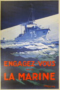 | Details | Theunissen, A. | 1930 |
| Engagez-vous dans la Marine |
|
Theunissen, A. |
|
| 1930 |
| LOC:0 |
| $650.00 | Theunissen--A- | Engagez-vous-dans-la-Marine | Large, dynamic, post-WWI recruiting poster for the French navy dated to 1930. Depicts a fast patrol boat or destroyer. <BR> </BR>
Lithograph, signed in the plate by A. Theunissen, followed by the symbol of an anchor which is one of the privileges accorded those artists who have been appointed as official "Peintre de la Marine". Theunissen was given that honor in 1925 by the French Minister of Defense in recognition of his artistic work for the French Navy or maritime subjects . Published by Devambez, Paris. 1930. |
| 6845 |  | Details | Fairchild Aerial Surveys Inc. | 1930 |
| Scarce view of Hollywood Stars Homes Beverly Hills |
|
Fairchild Aerial Surveys Inc. |
|
| 1930 |
| LOC:89 |
| $400.00 | Fairchild-Aerial-Surveys-Inc- | Scarce-view-of-Hollywood-Stars-Homes-Beverly-Hills | Scarce, early photographic oblique "airplane" birds-eye view of Beverly Hills, California annotated with numerals keyed to homes of Hollywood stars. These movie stars include Buster Keaton, Tom Mix, Mary Pickford, Douglass Fairbanks, Charles Chaplin, Marlene Dietrich, and Will Rogers. The view probably dates between 1926 and 1933 based on the marriage duration of King Vidor and Eleanor Boardman (Home # 22) . By Fairchild Aerial Surveys, N.Y.C. Published in an unknown magazine. Verso with glamour photographs of period stars.
<br><br>
The view looks roughly north with the Beverly Hills Hotel, established 1912, slightly to the left of the center. This item may be the earliest published aerial photograph of Photomap of Beverly Hills to locate the homes of movie stars and likely predates Landacre's "Newe Mappe of the Heavens."
<br><br><div class="indenttextblocksingle">
"When Wallace Beery flies back from his island camp, or when Ben Lyon volplanes down home to see Bebe and the baby, this is where the magic carpet of Hollywood looks to the returning wanderers of the sky."
</div><br> |
| 5350 |  | Details | Speck, Rose M. | 1934 |
| Mississippi River paddleboat cruise to New Orleans broadside |
|
Speck, Rose M. |
|
| 1934 |
| LOC:9 |
| $625.00 | Speck--Rose-M- | Mississippi-River-paddleboat-cruise-to-New-Orleans-broadside | Rare original 1934 broadside for a two week Mississippi River cruise aboard the paddleboat Cape Girardeau. The event, limited to 100 passengers, was planned to depart New York on March 31, 1934 and was sponsored by Rose M. Speck of New York City.
<br></br>
<b>"Two weeks of Adventure on the Lower Section of the Mighty Mississippi -- Aboard the picturesque steam packet "Cape Girardeau"-- Monarch of the River"</b>
<br></br>
The $139 fare included a pullman train from New York to Memphis, Tennessee complete with a recreation car. Aboard the riverboat, passengers could plan on a two-day layover in New Orleans along with onboard entertainment including:
<div class="indenttextblocksingle">
<ul style="list-style-type: circle;">
<li>"Darkey spiritual singers"</li>
<li>Square dances</li>
<li>Costume balls</li>
<li>Masquerades</li>
<li>Deck sports</li>
<li>Sun baths</li>
<li>Swimming in the Gulf of Mexico</li>
</ul>
</div> |
| 4767 | 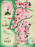 | Details | Botelho, Carlos | 1937 |
| Portugal 1937 Exposition Internationale de Paris |
|
Botelho, Carlos |
|
| 1937 |
| LOC:88 |
| $400.00 | Botelho--Carlos | Portugal-1937-Exposition-Internationale-de-Paris | Very fine map of Portugal in a simple, folksy, pictorial style. For a brochure "Portugal Gastronomique" to support the Portugese exhibit at the 1937 International Exhibition of Arts and Techniques in Paris, France May 4 to November 27, 1937. There, pavilions of the participating countries were built along the Seine. These structures were projects by the outstanding architects of the time.
<br></br>
On the recto French text written by Albino Forjaz Sampaio and simple images related to traditional Portugese food.
(Source: http://garfadasonline.blogspot.com/2013/04/portugal-gastronomico-na-exposicao-de.html
<br></br>
Signed within as "Botelho 37". Carlos Botelho (1899-1982) was a multi-faceted artist, illustrator, and caricaturist. Lito National - Porto. |
| 5107 |  | Details | Clegg, Ernest | 1937 |
| Chart of the Waters between Newport Block Island and Marthas Vineyard |
|
Clegg, Ernest |
|
| 1937 |
| LOC:88 |
| $155.00 | Clegg--Ernest | Chart-of-the-Waters-between-Newport-Block-Island-and-Marthas-Vineyard | Decorative chart of the waters between Newport, Rhode Island, Block Island, & Marthas Vineyard, Massachusetts for the America's Cup races in 1937, after Ernest Clegg. Contains historical information and boat images for previous America's Cup races. Side panel with an explanation of the chart. Ropework outline. Reduced size, not engraved and printed by Beck.
<br></br>
Ernest Clegg (1876-1954) was a yachtsman, calligrapher, graphic designer, and cartographer. Among numerous other works, Clegg designed a series of three decorative charts recording the America's Cup Races off Newport, RI in 1930, 1934 and 1937.
<br></br>
From the August 7, 1937 issue of the Illustrated London News. |
| 6487 | 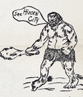 | Details | Anonymous | 1938 |
| Roadside attraction flyer for mythical Hidden City South Dakota |
|
Anonymous |
|
| 1938 |
| LOC:78 |
| $135.00 | Anonymous | Roadside-attraction-flyer-for-mythical-Hidden-City-South-Dakota | Very scarce advertising flyer ca. 1938 with map for the long-forgotten <strong>Hidden City</strong>, a roadside attraction in South Dakota's Black Hills; Admission 25 cents.
<br><br>
<div id="ll" align="center">
<a title="Hidden City, SD"></a>
<img id="ii" src="/ZoomifyImages/SC_6487/SC_6487_DinoSign.jpg" alt="1940s sign for Hidden City Roadside Attraction" width="260"/> <br><small>1940s road sign for Hidden City <br>(not included)</small>
</div><br>
The recto teases "Did Alley Oop ? ? ? ? ? ." "Prehistoric Walls, Cross Walls, Arches and Pavements with Hieroglyphics. Lost City?" and includes a crude drawing of 1930s artist's concept of a caveman, complete with loincloth and club.
<br><br>
</ul>
</div>
<div id="1z" align="center">
<a title="Hidden City, SD"></a>
<img id="3" src="/ZoomifyImages/SC_6487/SC_6487_Detail.jpg" alt="" width="300"/> <br><small>Hidden City, South Dakota Roadside Attraction</small>
</div><br>
Verso with a road map of South Dakota highlighting the location of a number of area attractions, both large and small. The less well-known of these attractions include:
<div class="indenttextblocksingle">
<ul style="list-style-type: circle;"></li>
<li>Black Hills Rock Museum</li>
<li>Black Hills Sugar Factory, Belle Fourche</li>
<li>Stage Barn Caverns</li>
<li>Water Carnival and Race Meet</li>
<li>Nameless Cave</li>
<li>Strato Bowl</li>
</ul>
</div>
Earl Brockelsby, who later started another attraction in 1937, Reptile Gardens, worked as a tour guide at Hidden City. |
| 4982 | 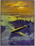 | Details | Heckman, Ruehl Frederick | 1939 |
| Aviation Advertising Dawn of a New Age Manhattan Sample Calendar |
|
Heckman, Ruehl Frederick |
|
| 1939 |
| LOC:200 |
| $215.00 | Heckman--Ruehl-Frederick | Aviation-Advertising-Dawn-of-a-New-Age-Manhattan-Sample-Calendar | Fine 1939 Art Deco sample calendar by artist Ruehl Heckman (1890-1942). This aviation-related calendar "Dawn of a New Age" shows a four-engine aircraft cruising above Manhattan as the sun breaks through the morning clouds to the east. The 'dawn' could be considered to be the end of the Great Depression which started with the stock market crash in October, 1929 and ended in the late 1930's.
<br><br/>
This original calendar was printed by the Thomas D. Murphy Company of Red Oak, Iowa "The Birthplace of Art Calendars." With a single unmarked calendar sheet for January 1939. New York City.
<br></br>
Heckman had homes in Pasadena and Laguna Beach, California until 1942 when he died in an auto accident. |
| 5349 |  | Details | Phelps, Donald | 1940 |
| Pre-WWII design and topographic layout for a system to protect airfields |
|
Phelps, Donald |
|
| 1940 |
| LOC:9 |
| $250.00 | Phelps--Donald | Pre-WWII-design-and-topographic-layout-for-a-system-to-protect-airfields | One-of-a-kind cyanotype or blueprint conceptual design document for a system of electrically-controlled hydraulic rams designed to protect airfields from unwanted landings.
<div class="indenttextblocksingle">
"Air field protection columns can be raised or lowered at will thus allowing landing of friendly planes, and within 1 or 2 minutes raised as protection against landing of enemy planes or gliders."
</div>
</br>
The blueprint includes a detailed design drawing of a single protection column and a topographic layout of the airfield protection system including the airfield protection columns, central control station, compressor pits and electrical control cables.
<br></br>
By Donald Phelps of Highland Park, Illinois. Dated September 7, 1940.
<br></br>
With a letter (and envelope) dated March 30, 1942 from Donald Phelps to the National Inventor's Council at the U.S. Department of Commerce seeking advice as to whether the system would be of value to the U.S. or British governments. Phelps was associated with the Phelps Agency, Steamship and Vessel Agents of Chicago, Illinois. |
| 5220 |  | Details | Women's Army Corps | 1944 |
| Stand-up Poster for WAC Topographic Draftsman |
|
Women's Army Corps |
|
| 1944 |
| LOC:13 |
| $225.00 | Women-s-Army-Corps | Stand-up-Poster-for-WAC-Topographic-Draftsman | Among the key events impacting the women's movement was World War II. With men away at war, tens of thousands of women entered the workforce to meet the demands of the war for labor. Among the most well-known was "Rosie the Riveter". Here we might have an advertisement to fill the job of "Carrol the Cartographer".
<br></br>
A table-top, stand-up World War II recruitment poster printed on heavy card stock for the Women's Army Corps (WAC) depicting a woman drawing on a map with pencil and protractor. The job specialty promoted is Topographic Draftsman, part of the Army Ground Forces.
<br></br>
With a black ink over-stamp for the U. S. Army Recruiting Station, Room 217 New Post Office Building, Utica N. Y. Illustration is signed but unreadable. |
| 5223 |  | Details | National Fire Service Benevolent Fund | 1944 |
| Bird's-eye View of the V1 Bomb an Early Cruise Missile |
|
National Fire Service Benevolent Fund |
|
| 1944 |
| LOC:13 |
| $110.00 | National-Fire-Service-Benevolent-Fund | Bird-s-eye-View-of-the-V1-Bomb-an-Early-Cruise-Missile | Single-page folding booklet with a schematic diagram of the German V-1 bomb flying above a bird's eye view of the British countryside. The V-1 was a German weapon, an early and crude cruise missile, designed to strike terror into the British population. During World War II Germany used the V-1 in the thousands against south-east England from launch sites along the French and Dutch coasts.
<br></br>
Reproduced from the London Illustrated News with proceeds devoted to the National Fire Service Benevolent Fund.
<br></br>
With text, cutaway drawings, and inset schematic diagrams explaining of the German impulse engine (an early jet engine) and the mechanism used to control the missile's flight path. Verso with text and title page.
<br></br>
Price when issued: sixpence. Drawn by G.H. Tavis. 1944. Printed by Temple Fortune Press. Printers. London. |
| 6450 |  | Details | Gluck, Jay | 1948 |
| Cartoon cutaway view of UC Berkeley dormitory life |
|
Gluck, Jay |
|
| 1948 |
| LOC:1 |
| $1,000.00 | Gluck--Jay | Cartoon-cutaway-view-of-UC-Berkeley-dormitory-life | With the premiere of the IMAX biopic "Oppenheimer" (1) less than one week away (7/18/2023) we offer "Oppy's Flop House", a rare and culturally insightful 1948 cartoon cutaway elevation view of a dormitory at the University of California at Berkeley, where Oppenheimer taught physics from 1929 to 1943.
<br><br>
<div id="0" align="center">
<a title=""></a>
<img id="6450" src="/ZoomifyImages/SC_6450/SC_6450_detail_1.jpg" alt=" Rare, culturally insightful 1948 cartoon cutaway elevation view of a dormitory at the University of California at Berkeley, where Oppenheimer taught physics from 1929 to 1943." width="300"/> <br><br> <font size="-2">Oppy's Flop House- Oppenheimer Caricature Detail</font>
</div><br>
Oppy's Flop House was published in the 1948 annual "Mad Engineer" issue of "California Engineer", a student publication of the University of California at Berkeley.
<br><br>
The title "Oppy's Flop House" refers to Robert Oppenheimer [2], one of the key researchers on the Atomic Bomb that had been dropped on Japan less than three years earlier. Cartoons and sight gags include a slide rule used as a fishing device and as a guitar, chem lab equipment used to brew coffee, students using radar to peer into the room of a bathing coed, a robot, a device based on compressed air to raise the skirts of coeds, and many scenes that include engineering book gags.
<br><br>
[1] https://www.oppenheimermovie.com/<br>
[2] Physicist <strong>Robert Oppenheimer</strong> (1904-1967) was Project Director for the <strong>Manhattan Project</strong>. Oppenheimer taught at UC Berkeley from 1929 - 1943. "With the rise of the Nazi party in Germany, the University quickly became a hub for atomic weapons development. By the outbreak of World War II, Oppenheimer, his students, and several notable physicists probed atomic theory on the top floor of Le Conte Hall." |
| 6428 |  | Details | Anonymous | 1949 |
| Cartoon map of UC Berkeley engineering underground radiation nuclear laboratory |
|
Anonymous |
|
| 1949 |
| LOC:300 |
| $850.00 | Anonymous | Cartoon-map-of-UC-Berkeley-engineering-underground-radiation-nuclear-laboratory | Original centerspread 1949 cartoon pictorial map, "Underground Campus", the campus of the University of California Berkeley, specifically the engineering underground tunnels and facilities including the Radiation Lab. Scientists at the UC Radiation Laboratory, now the Lawrence Berkeley National Laboratory, discovered berkelium (atomic number 97) in 1949 using a 60-inch cyclotron.
<br></br>
<div id="3" align="center">
<a title="California Engineer smoking weed?"></a>
<img id="3" src="/ZoomifyImages/SC_6428/SC_6428_SmokingWhat.jpg" alt="Early depiction of a Berkeley Engineer with roach clip." width="240"/>
</div><br>
The California Engineer began in 1903 as the California Journal of Technology. It was the first college magazine in the west to specialize in the area of science and technology. In January, 1923, after a hiatus of ten years, the magazine was revived and renamed "California Engineer" by the Student Engineers Council (1).
<br></br>
The comical map is centered around Sather Tower with a cutaway view of the subterranean network below the halls at the University of California at Berkeley. Includes Sather tunnel, Leconte Hall, Gilman Hall, Wheeler Auditorium, The Radiation Laboratory housed the research at UC Berkeley during WWII under the Manhattan Project. Note the IBM punch card machine gag at bottom left.
<br></br>
The comical map is from the January 1949 issue of <b>California Engineer</b>, the annual "Mad Issue". 36 pages. Price when issued 25 cents. Published at the University of California, Berkeley, California by the Associated Students of the University of California. |
| 436 |  | Details | Gudin, Baron Theodore | 1950 |
| Combat d'une vaisseau Francais contre quatre vaisseaux Anglais |
|
Gudin, Baron Theodore |
|
| 1950 |
| LOC:9 |
| $140.00 | Gudin--Baron-Theodore | Combat-d-une-vaisseau-Francais-contre-quatre-vaisseaux-Anglais | Depicts a battle in 1655, near Majorca, between a French ship of 30 cannon "Le Persee" and a group of 4 English vessels. The Persee, captained by the Chevalier de Valbelle, a Knight of Malta, was attacked by a group of 4 English warships in retribution for his previous action in which he attacked and boarded an English vessel after the English vessel demanded a salute. (Source: England in the Mediterranean: A Study of the Rise and Influence of British …, Sir Julian Stafford Corbett, Google Books. 1917)<BR> </BR>
This fine work from the original 19th century plate, is a 20th century reprint by the Louvre of an etching and engraving on steel plate by Chavane. Subject matter is based on a painting by French Marine Painter Baron Theodore Gudin (1802-1880 ) in 1846. <BR> </BR>
With the circular embossed stamp of "Musee Louvre Chalcographie". La Chalcographie du Louvre is a repository of more that 13,000 plates from the Louvre's archives, housed upstairs above the Louvre's Paris galleries . Upon request visitors can have a engraving produced from one of those original plates by master printers on museum-quality paper. |
| 5343 |  | Details | Kidden, R. U. | 1956 |
| Humorous blueprint for a nuclear powered ship |
|
Kidden, R. U. |
|
| 1956 |
| LOC:55 |
| $600.00 | Kidden--R--U- | Humorous-blueprint-for-a-nuclear-powered-ship | One-of-a-kind, striking, original humorous cyanotype or blueprint diagram of a nuclear powered ship drawn in the era immediately after WWII when two hydrogen bombs helped end the war with Japan. In 1955, the United States commissioned the world's first nuclear powered vessel, the submarine U.S.S. Nautilus. The world's first nuclear-powered surface ship, the cruiser Long beach, was not commissioned into service until September, 1961.
<br></br>
Almost every feature on the ship has something wrong with it such that anyone familiar with ship design would find it amusing, yet the overall structure of the engineering drawing with the title block and sections for revisions and specifications, made the drawing seem plausible from a distance. Includes humorous mis-spellings and a crazy network of piping.
<br></br>
One of the key features is that many of the ship's features are labeled in Russian as well as English, reflecting the Cold-war competition between the two powers. Revision E3 explains "Added Russian translation applying to complete ship to save time when prints are stolen." Other funny bits include:
<br></br><div class="indenttextblocksingle">
<ul style="list-style-type: circle;">
<li>Outhouse on the stern is piped into the crew's forward supply tanks.</li>
<li>Floatplane on an upper deck has its floats mounted backwards.</li>
<li>Split-level crow's next is comprised of two stacked birdhouses.</li>
<li>Captains balls mounted on a upper guy wire (they belong on the compass)</li>
<li>Mid 19th-cenutury cannon part of the armament mounted on the bow.</li>
<li>The propeller is misshapen and dinged up.</li>
<li>The vessel is 100 feet long but 75 feet wide.</li>
<li>The plans are checked and approved by R. U. Kidden and I. M. Nuts.</li>
<li>Large pipe for radioactive waste flows into the crew's quarters.</li>
<li>Sickbay is shown stacked with caskets .</li>
</ul>
</div> |
| 451 |  | Details | Decaris, Albert | 1958 |
| Salon de la Marine |
|
Decaris, Albert |
|
| 1958 |
| LOC:50 |
| $195.00 | Decaris--Albert | Salon-de-la-Marine | Very decorative medium-format original two-color poster shows <strong>Neptune</strong> grasping a trident while cradling a sailing vessel. The poster was produced to promote the Salon de la Marine, held in 1958 at the <strong>Paris Musee de la Marine.</strong> The Salon is an event held at the National Marine Museum in Paris to display maritime art by invited artists and by artists named as "Peintre de la Marine" or official marine painter.
<BR> </BR>
By <strong>Albert Decaris</strong>, one of France's top engravers in the 20th century. Decaris was honored with the post of the official painter of the Marine Française in 1962. |
| 5222 |  | Details | Paine, Howard E. | 1963 |
| Lot of 3 manuscript design options for Round Earth on Flat Paper NGS |
|
Paine, Howard E. |
|
| 1963 |
| LOC:62 |
| $1,200.00 | Paine--Howard-E- | Lot-of-3-manuscript-design-options-for-Round-Earth-on-Flat-Paper-NGS | Three manuscript sketches, design options by Howard Paine for The Round Earth on Flat Paper used on the inside back cover of the National Geographic Society's first Atlas of the World. <i>(National Geographic Society. 1963.)</i>. From the estate of Howard Paine, Art Director at National Geographic until 1990.
<br><br>
Note: The first image of the four displayed, is from the 1963 NGS Atlas and is for comparison only. Not included.
<br><br>
The booklet "The Round Earth on Flat Paper: Map Projections Used by Cartographers" by Wellman Chamberlin was first published by the National Geographic Society in 1947. In 1963 Chamberlin and Paine collaborated on the design of the inside back and front covers for National Geographic's first <b>"Atlas of the World"</b>: <i>The Earth in Space and The Round Earth on Flat Paper</i>. For <i>The Round Earth on Flat Paper</i> Paine sketched several alternate options. The influence of Paine's early designs are evident in the final design selected for the atlas.
<br><br>
From 1957 to 1990 Howard Paine was a Graphic Artist and eventually Art Director at National Geographic. Mr. Paine was responsible for design changes to the National Geographic magazine cover that over time replaced the old-fashioned border of clustered oak and laurel leaves with a simplified, more modern design that included photographs. Also, during the period 1981 to 2012 Mr. Paine was Art Director for the U.S. Postal Service. In that role Paine was responsible for the design of over 400 stamps including the 29-cent Elvis Presley stamp, with over 500 million sold.
<br><br>
Sources:
<br>
http://www.howardepaine.com/ngs.php |
| 5193 |  | Details | Anonymous | 1969 |
| Centennial Pageant Poster for Pecatonica Illinois |
|
Anonymous |
|
| 1969 |
| LOC:53 |
| $175.00 | Anonymous | Centennial-Pageant-Poster-for-Pecatonica-Illinois | Poster for the Pecatonica, Illinois Centennial Pageant to be held at the Winnebago County Fairgrounds on June 13 and 14, [1969]. Colorful view of settlers battling native Americans. Pecatonica, in Winnebago County, was incorporated in March 1869, after a period of growth when the railroad first started service through the area. |
| 6712 |  | Details | Red Mountain Tribe | 1970 |
| Terrorism 1970's style |
|
Red Mountain Tribe |
|
| 1970 |
| LOC:86 |
| $200.00 | Red-Mountain-Tribe | Terrorism-1970-s-style | This is a title page to a 1970 issue of the Berkely Tribe newspaper- an anthropomorphized earth scowling with locations noted across his face that were the scene of left-inspired bombings, fire bombings, pipeline attacks, the odd embassy siege, and riots. Published in 1970, during the Vietnam war by the Red Mountain Tribe (1) with parallels to the tensions experienced today by the other side of the aisle.
<br><br>
The use of symbols as propaganda was a common tactic among activists during this time, and the Earth was a particularly powerful symbol of the counterculture's environmentalism and concern for the planet. By depicting the Earth as an old man with a scowl, the artist was likely attempting to convey a sense of anger and frustration at the destruction caused by the war and other government policies. The Earth's face being marked with locations that were the scene of attacks further reinforced the counterculture's proposition that the US government was engaging in destructive and unjust actions.
<br><br>
<div id="0" align="center">
<a title="Berkeley Tribe 1970"></a>
<img id="3" src="/ZoomifyImages/SC_6712/SC_6712_detail.jpg" alt="Anthropomorphized view of earth scowling with locations noted across his face that were the scene of left-inspired terror attacks." width="340"/> <br><small>... What's the world coming to?</small>
</div><br>
Berkely Tribe. 1970. Vol. 2 No. 8 Issue 34. Feb. 27 - Mar.6, 1970.
<br><br> |
| 5473 |  | Details | Student Mobilization Committee | 1971 |
| Very rare persuasive 1971 antiwar poster with outline map of southeast Asia |
|
Student Mobilization Committee |
|
| 1971 |
| LOC:87 |
| $475.00 | Student-Mobilization-Committee | Very-rare-persuasive-1971-antiwar-poster-with-outline-map-of-southeast-Asia | Rare, student-led anti-war protest poster on card stock with an outline map of SE Asian countries promoting two anti-war activities: A "Student Strike" on November 3 and a "March on Boston" planned for November 6 [1971] .
<br></br>
The text for the Strike and the March are both overlaid on top of an outline image of a map of SE Asia including the countries of North and South Vietnam, Laos, and Cambodia each filled with the letters "USA", "USA", "USA".
<br></br>
No holdings of this poster are found online.
<br></br>
The two protest activities were organized by the Student Mobilization Committee (SMC). 15 Sellers Street, Cambridge, Massachusetts.
<div class="indenttextblocksingle">"The Student Mobilization Committee was formed in 1966 “to coordinate opposition to U.S. involvement in the war in Vietnam among college and high school students.” Originally named The Vietnam Day Committee the SMC organized protests on campuses and in cities in addition to being one of the first groups that included civilians and soldiers alike. Based on a letter from 1969, the SMC had centers in 15 cities around the country but began to disband, like many anti-Vietnam groups in the early 1970s (1973) in conjunction with the U.S. beginning to withdrawing troops from Vietnam." (Brown University, Hall-Hoag Collection. 2015. Online) </div> |
| 6678 |  | Details | U.S. Coast Guard | 1972 |
| Coast Guard Poster worldwide locations |
|
U.S. Coast Guard |
|
| 1972 |
| LOC:86 |
| $145.00 | U-S--Coast-Guard | Coast-Guard-Poster-worldwide-locations | Decorative old-stock promotional poster ca. 1973 (1) with the locations of the U.S. Coast Guard around the world, or at least the western world. Executed with elements of 70's style reflecting the influence of the counter-culture on the arts during that period. With the Coast Guard motto : Semper Paratus or Always Ready.
The map omits any locations in Asia, where during that time period there was a war raging in Vietnam. Reminding the viewer of that overseas duty station was probably not conducive to the CG recruiting effort in '73.
<br><br>
Legend at bottom lists the activities and programs the U.S. Coast Guard engaged in including:
<div class="indenttextblocksingle">
<ul style="list-style-type: circle;">
<li>Icebreaking</li>
<li>Iceberg Patrol</li>
<li>Fisheries Conservation</li>
<li>Radio Navigation</li>
<li>Port Safety Vessel Traffic System</li>
<li>Search and Rescue</li>
<li>Aids to Navigation</li>
<li>Law Enforcement</li>
</ul>
</div>
(1) We have dated the map with reference to the planned Omega Station shown on the continent of Australia. Planning for that station was underway as early as 1972 when the Australian Department of Shipping and Transport was making a final site selection decision. The Omega Navigation System was a global radio navigation system that operated from 1971 to 1997. It consisted of eight ground-based stations, including three in Alaska, that transmitted signals in the VLF (Very Low Frequency) range to provide accurate navigation information for ships and aircraft. The Omega Navigation System was eventually replaced by more modern and precise satellite-based navigation systems such as GPS (Global Positioning System)
<br><br>
Document ID: G-PMR30 |
| 6504 |  | Details | McClure, Jim | 1973 |
| Fine etching of the New Orleans French Market |
|
McClure, Jim |
|
| 1973 |
| LOC:78 |
| $300.00 | McClure--Jim | Fine-etching-of-the-New-Orleans-French-Market | Fine limited-edition etching of life at the French Market in New Orleans, Louisiana. Very nicely and accurately captures the mood and atmosphere of the French Market and French Quarter in the early 1970's. Titled, dated and signed by the artist. No. 105 of 200. |
| 6605 |  | Details | Black Star Liberation Press | 1974 |
| Astrology and Black People Zodiacal Chart |
|
Black Star Liberation Press |
|
| 1974 |
| LOC:89 |
| $695.00 | Black-Star-Liberation-Press | Astrology-and-Black-People-Zodiacal-Chart | Unrecorded, a bit strange and highly unusual astrological or horoscope poster: "Astrology and Black People" an apparently self-published poster from Berkeley, California in 1974.
<div><img src="/ZoomifyImages/SC_6605/SC_6605_detail.jpg" alt="Title cartouche details for 1974 Astrology and Black People zodiacal chart published by Black Star Liberation Press" width="300" align="center" style="margin: 20px 20px 20px"/>
</div>
The creator's faces, names, astrological sign, and role appear at bottom center in a far-out UFO-style title cartouche: Reggie, layout; Gypsie, astrologer; Detroit, artist; Wayne, details; and Jason, ideas. Black Studies interest.
<br><br>
Published and copyrighted 1974 by Black Star Liberation Press, P.O. Box 3215 Berkeley, California. Verso is blank. |
| 6432 |  | Details | Konnertt, Jean | 1980 |
| Poster first annual Cajun Bluegrass Festival Escoheag Rhode Island |
|
Konnertt, Jean |
|
| 1980 |
| LOC:87 |
| $355.00 | Konnertt--Jean | Poster-first-annual-Cajun-Bluegrass-Festival-Escoheag-Rhode-Island | Rare original serigraph concert poster for the first annual Rhode Island Cajun - Bluegrass Festival held at the Stepping Stone Ranch in Escoheag, RI in October, 1980. Skillful application of graphic and cartographic elements link Louisiana with Rhode Island.
<br><br>
Numbered 7/100 and signed by artist in pencil. |
| 5426 |  | Details | Franzen, Dana | 1982 |
| Poster Ron and Nancy Reagan White House SmokeIn 1982 |
|
Franzen, Dana |
|
| 1982 |
| LOC:300 |
| $295.00 | Franzen--Dana | Poster-Ron-and-Nancy--Reagan-White-House-SmokeIn-1982 | Original, cannabis-related protest poster promoting the White House Smoke-In '82 Washington, D.C. July 2 - 5. Promising free pot, the poster features President Ron Reagan sporting a huge smoldering doob while standing next to an elegant Nancy Reagan, both garlanded with green cannabis leaves. Above that ironic scene, on an arched semicircle, the text reads: <strong>"Pot is an herb. Reagan is a dope." </strong>
<br></br>
Created by Dana Franzen, a frequent contributor to the magazine's centerfold posters..
<br></br>
Offset-lithograph on better-quality newsprint. Measuring 25" on the diagonal this is an original poster from a 1982 issue of A Yipster Times Publication. |
| 5172 |  | Details | Campbell | 1983 |
| Original manuscript art for Reagan era Central America Game cartoon |
|
Campbell |
|
| 1983 |
| LOC:200 |
| $1,750.00 | Campbell | Original-manuscript-art-for-Reagan-era-Central-America-Game-cartoon | Rare original manuscript art by Campbell for Reagan era "Central America Game" cartoon, 1983. This one-of-a-kind satirical cartoon references decades of United States involvement in attempts to overthrow Central and South American governments (Cuba, Panama, Chile, Venezuela ), some successful.
<br></br>
Set surrounded by sea, spanning a globe, political leaders conduct a dialog above a gameboard emulating the landmass of Central America with Pinochet and Castro as board pieces. Ronald Reagan asks Henry Kissinger about the rules for meddling in the Americas. Dialog:
<div class="indenttextblocksingle">
<b>Ronald Reagan: </b>"How do you win this 'Central America' game Henry?"<br>
<b>Henry Kissinger: </b>"I'm not sure anyone ever has, Mr. President."
</div>
</br>
Pen and ink manuscript sketch with a few edits in white-out. Signed "Campbell Aug 11, 1983."
<br></br> |
| 7898 |  | Details | Port of San Francisco | 1984 |
| Port of San Francisco The Orient starts from here |
|
Port of San Francisco |
|
| 1984 |
| LOC:141 |
| $300.00 | Port-of-San-Francisco | Port-of-San-Francisco-The-Orient-starts-from-here | Pictorial advertising poster for the Port of San Francisco, California.
<br><br>
Japanese text at the top of the image reads "サンフランシスコの港 東洋はここからはじまる" which translates to "Port of San Francisco - The Orient starts from here".
<br><br>
The depicts view San Francisco as a gateway or starting point to the East/Orient from the perspective of the United States, but in a stylized, somewhat fantastical way. The port and various ships are prominently featured, emphasizing San Francisco's role as a major port city connecting the U.S. to Asia.
<br><br>
The map includes various landmarks and geographic features of the San Francisco Bay Area, such as the Golden Gate Bridge, downtown San Francisco skyscrapers, boats in the bay, and the hilly terrain. However, the proportions and layouts are not geographically accurate.
<br><br>
Interestingly, the hills and mountains are rendered in a colorful, undulating style reminiscent of Japanese ukiyo-e landscape prints. This gives the map a unique artistic interpretation blending American and Japanese aesthetics. The whimsical, simplified style seems designed to engage and orient viewers while capturing the general character of the Bay Area.
<br><br>
Published by the Port of San Francisco in 1984. Artists' signature at bottom right is either Waggoner or Waffoner. |
| 5424 |  | Details | Swartzbeck, Mike | 1984 |
| Iconic Yipster Poster Texas State Reagan Mechanical Bull |
|
Swartzbeck, Mike |
|
| 1984 |
| LOC:300 |
| $200.00 | Swartzbeck--Mike | Iconic-Yipster-Poster-Texas-State-Reagan-Mechanical-Bull | Fine mid-80's original protest-rally poster, an iconic offset-lithographed artifact from the waning days of the Hippy sub-culture. A broadsheet for the more liberal segment of the Baby Boomer cohort, with a Texas accent.
<br></br>
Ronald Reagan is depicted astride a missile-shaped quarter-a-ride mechanical bull emblazoned with the atom symbol, with all set before the shape of the State of Texas, in blazing yellow. Text at the right lays out the rally schedule in Dallas, Texas at the Republican Party Convention from August 11 to August 24, 1984. Activities included a Peace Vigil, religious services, voter registration, and a Rally Against Reagan's Diversion of Dollars from Hard to Soft Drugs. Created by Mike Swartzbeck and apparently paid for by the North American Greens Party, P.O. 392, Canal Street Station, New York City.
<br></br>
Activities planned for Wednesday, August 22 were:
<div class="indenttextblocksingle">
<ul style="list-style-type: circle;">
<li>Morning: Toxic Waste Redeployment</li>
<li>Evening: blockade Convention</li>
</ul>
</div>
Title: "Don't Let Reagan take you For a Ride. Rally and Blockade Dallas G.O.P. Convention, Aug. 11 - 24 [1984]." |
| 6481 |  | Details | Anonymous | 1986 |
| Decorative serigraph poster City of San Francisco Ferry |
|
Anonymous |
|
| 1986 |
| LOC:1404 |
| $180.00 | Anonymous | Decorative-serigraph-poster-City-of-San-Francisco-Ferry | Fine decorative nautical-themed limited-edition silk-screen poster of San Francisco Bay, California and the ferry "City of San Francisco" from the eighth-annual users conference held by Data Design Associates in 1987. Deep rich colors. Signed within (illegible). Number 579 of 700 copies.
<br><br>
Data Design Associates, Inc., was a Sunnyvale, Calif-based developer of mainframe financial software. |
| 6482 |  | Details | Anonymous | 1986 |
| Decorative serigraph poster San Francisco Bay and Coit Tower |
|
Anonymous |
|
| 1986 |
| LOC:1404 |
| $175.00 | Anonymous | Decorative-serigraph-poster-San-Francisco-Bay-and-Coit-Tower | Fine decorative nautical-themed limited-edition silk-screen poster of San Francisco Bay, California and Coit Tower from the fifth-annual users conference held by Data Design Associates in 1984. Deep rich colors. Signed within (illegible). Number 472 of 500.
<br><br>
Data Design Associates, Inc., was a Sunnyvale, Calif-based developer of mainframe financial software. |
| 4746 |  | Details | Leary, Pat | 1987 |
| Limited edition print of Amelia Island, Florida |
|
Leary, Pat |
|
| 1987 |
| LOC:61 |
| $175.00 | Leary--Pat | Limited-edition-print-of-Amelia-Island--Florida | Signed and numbered decorative limited-edition nautical print of the coast near <b>Amelia Island, Florida</b>. This fine modern print features a 20th-century Coast Survey chart of the Atlantic Coast in that area overlaid with a eighteenth-century "Plan of Amelia Island in East Florida" by Fuller/Jefferys. With images of shrimp boats, nets and other artifacts that evoke the laid-back low-country charm of that area.
<br></br>
Signed in pencil and dated within to 1987. Number 399/500.
<br></br>
A fine original gift for those with interests in boating, fishing, or beach recreation in the area near Amelia Island or the Florida Altantic Coast. |
| 6813 |  | Details | McMillan, | 1990 |
| Dynamic Clearwater Florida Sailing Poster |
|
McMillan, |
|
| 1990 |
| LOC:55 |
| $95.00 | McMillan- | Dynamic-Clearwater-Florida-Sailing-Poster | Dynamic glossy sailing poster for the 1990 Florida Coastal Management Conference: Navigating the Nineties by McMillan. The 1990 Florida Coastal Management Conference was held in Clearwater, Florida during September 26 - 28.
<br><br>
Could be trimmed and framed. Image alone is ~ 12" x 30". |
| 5486 |  | Details | Revolutionary Worker | 1991 |
| Communist Party protest cover poster cartographic propaganda |
|
Revolutionary Worker |
|
| 1991 |
| LOC:87 |
| $325.00 | Revolutionary-Worker | Communist-Party-protest-cover-poster-cartographic-propaganda | Slogan-oriented cover from Revolutionary Worker, a publication "Voice of the Revolutionary Communist Party, USA." Scarce late 20th-century Communist propaganda (1991) depicting the "Rulers of America" as pigs.
<br></br>
Another propagandistic use of a world map with North America depicted tilted aggressively to the east as Russia tilts west in the direction of the U.S.A., a distortion permitted by the unusual projection of the world enabled by the map's use of map as tablecloth metaphor. Tumbling pigs to right disguise the true intent of this 1991 International Workers Day cover. Handcuffs, cash, missiles, jets, and artillery pieces represent the existing Racists and Rambo-Americans, Rulers of America: <strong>It's all going to fall on you!</strong>"
<br></br>
<div id="Centered", Margin: 30px; /><br>
Downcasts,<br>
Slaves,<br>
Illegals,<br>
And Rebels:<br>
It's right to rebel!<br> |
| 7899 |  | Details | Greenville Avenue Area Business Association | 1992 |
| Pictorial Advertising Map of Greenville Avenue Dallas Texas |
|
Greenville Avenue Area Business Association |
|
| 1992 |
| LOC:141 |
| $300.00 | Greenville-Avenue-Area-Business-Association | Pictorial-Advertising-Map-of-Greenville-Avenue-Dallas-Texas | Large advertising poster of Upper Greenville Avenue, a vibrant neighborhood located in east Dallas, Texas, known for its diverse restaurants, lively entertainment scene, and walkable streets. Situated along Greenville Avenue, the area is home to a wide variety of dining options, ranging from casual eateries to upscale restaurants, as well as live music venues, bars, and pubs.
<br><br>
The neighborhood is surrounded by residential areas, primarily composed of single-family homes and apartments. Upper Greenville also features a mix of local boutiques, vintage stores, and specialty shops, catering to various tastes and interests. The area hosts several annual events, such as the Greenville Avenue St. Patrick's Day Parade and Block Party, which attracts thousands of visitors.
<br><br>
Copyright 1992-1993 Landmark Adventures. |
| 6327 |  | Details | Trudeau, Garry B. | 2005 |
| Signed Key West poster by cartoonist Garry Trudeau |
|
Trudeau, Garry B. |
|
| 2005 |
| LOC:87 |
| $355.00 | Trudeau--Garry-B- | Signed-Key-West-poster-by-cartoonist-Garry-Trudeau | Rare limited edition poster by Doonesbury cartoonist Garry Trudeau (1948 - ) promoting the 23rd Annual Key West Literary Seminar, Humor: January 6 - 16, 2005. Number 58 of 100 issued. Signed and numbered by Trudeau.
<br></br>
In 1975 Garry Trudeau became the first comic strip artist to win a Pulitzer Prize, an honor usually awarded to editorial page cartoonists. |