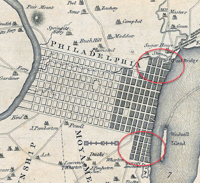
DESCRIPTION: Early plan of Philadelphia laid out on a grid between the Delaware River and the Schuylkill River. John Gibson engraved this fine original after Scull & Heap's smaller-scale plan of June, 1752 - "Plan of the city and environs of Philadelphia". Numerous homes are identified by name: Maddox, Plumsted, Pemberton, Rouse, Campbell and more. Shows the locations of two ferry's including Daniel Cooper's Ferry
A fine gift for anyone with an interest in Philadelphia, Pennsylvania or early colonial history. Volume 5. Page 20.
Gibson's plan though small, focuses on the city and omits the environs. Gibson has engraved the earliest affordable plan of Philadelphia pre-dating Bellin's work of 1764 by three years. Gibson's engraving clearly predates Faden's later revised edition (1771) of the Scull and Heap plan of Philadelphia. Scull and Heap show the city clearly with the Battery not yet demolished and lacking the numerous additional lots that Faden shows creeping outward near the Delaware River (see red circles).
PUBLICATION DATE: 1761
GEOGRAPHIC AREA: United States
BODY OF WATER: Delaware River
CONDITION: Very Good.
Clean. A tiny hint of toning at the edges. No notable condition issues.
COLORING: None
ENGRAVER: J. Gibson
SIZE: 5
" x
3 "
ITEM PHYSICAL LOCATION: 0
PRICE: $295
* Next Shipping Date is June 30, 2026

|