| | Thumbnail | | Creator | Date | Title / Author / Date / Location | Price | | | Description |
| 469 | 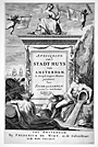 | Details | van Campen, Jacob | 1661 |
| Architecture Title Page |
|
van Campen, Jacob |
|
| 1661 |
| LOC:50 |
| $475.00 | van-Campen--Jacob | Architecture-Title-Page | Beautifully engraved antique title page to a volume of architectural drawings of the Amsterdam state house by artist Jacob Vennekool, after a sculpture by the Dutch sculptor Artus Quellinus. The town hall was built by <strong>Jacob van Campen</strong> during the period 1648-55. The building was itself an emblem of the great commercial successes of the Dutch, successes that were specifically celebrated in rich sculptural decorations.
<br></br>
This superb title page is adorned with putti playing trumpets and with symbols reflecting the importance of navigation and sea exploration to Amsterdam during the late 17th century: ships, anchor, cannon, and three backstaffs, as well as two nude figures representing <strong>New World native Americans.</strong> Less than 50 years earlier, in 1614, the Dutch founded a trading post in lower Manhattan, 'New Amsterdam', later New York.
<BR> </BR>
This page was published by Frederick de Widt (de Wit) in Amsterdam ca. 1661. Wit, a printer, publisher, and map seller, is well known today for the atlases and charts he published from Amsterdam in the mid to late 17th century. |
| 216 | 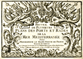 | Details | Michelot and Bremond | 1730 |
| Title Page - Recueil de Plusieurs Plans des Ports et Rades |
|
Michelot and Bremond |
|
| 1730 |
| LOC:4 |
| $475.00 | Michelot-and-Bremond | Title-Page---Recueil-de-Plusieurs-Plans-des-Ports-et-Rades | Title page to "Recueil de Plusieurs Plans des Ports et Rades de la Mer Mediterranee", <a rel="nofollow" href= "/MichelotBremondBackground.aspx">Henry Michelot and Laurens Bremond's</a> quarto-sized atlas of Mediterranean ports and harbors published between 1727 and 1730. This elaborately engraved title page is very rarely found alone, usually only as one of the 38 plates in a copy of the complete Michelot and Bremond atlas.
<BR> </BR>
Interesting note is that on the bottom neat line, previously engraved wording has been hastily covered over before printing, with just top and bottom of characters still visible. |
| 1056 | 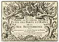 | Details | Michelot and Bremond | 1730 |
| Michelot Title Page - Recueil de Plusieurs Plans des Ports et Rades (2) |
|
Michelot and Bremond |
|
| 1730 |
| LOC:1 |
| $215.00 | Michelot-and-Bremond | Michelot-Title-Page---Recueil-de-Plusieurs-Plans-des-Ports-et-Rades-(2) | Title page to "Recueil de Plusieurs Plans des Ports et Rades de la Mer Mediterranee", <a rel="nofollow" href= "/MichelotBremondBackground.aspx">Henry Michelot and Laurens Bremond's</a> quarto-sized atlas of Mediterranean ports and harbors published between 1727 and 1730. This elaborately engraved title page is very rarely found alone, usually only as one of the 38 plates in a copy of the complete Michelot and Bremond atlas.
<BR> </BR>
Interesting note is that on the bottom neatline, previously engraved wording has been hastily covered over before printing, with just top and bottom of characters still visible. |
| 671 |  | Details | Anonymous | 1820 |
| Blank shipping document from du Roveray and Company of Havre |
|
Anonymous |
|
| 1820 |
| LOC:1 |
| $195.00 | Anonymous | Blank-shipping-document-from-du-Roveray-and-Company-of-Havre | Rare blank maritime shipping document dates from 1820's from du Roveray & Co. of Havre, France. With an image of a sailing ship at upper left. This template shipping document was designed so that the shipper could enter pertinent standard contractual information in the blank areas: ship's name, master's name, destination, recipients name, freight rate, number of bills of lading, and date.
<br></br>
The engraved document begins <div class="indenttextblock">"Shipped in good order and well-conditioned by DU ROVERAY & Co. of Havre; in and upon the good [blank] called the [blank] whereof is Master, for this present voyage [blank] now riding at anchor in the Port of Harve, & bound for [blank] to say [blank] …"<div> |
| 6521 | 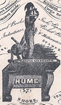 | Details | Nautical Warehouse | 1830 |
| Rare trade card Nautical Warehouse Leith Scotland harbor map |
|
Nautical Warehouse |
|
| 1830 |
| LOC:300 |
| $375.00 | Nautical-Warehouse | Rare-trade-card-Nautical-Warehouse-Leith-Scotland-harbor-map | Rare lithographed trade card c. 1830 for the Nautical Warehouse in Leith, Scotland. 4.5" x 3". As a logo a naval officer ("the Little Midshipman") is shown with a sextant taking a sighting atop a bracket shelf bearing the name "Hume."
<br><br>
Verso with a plan of Leith Harbor. The plan shows the East and West piers, a Martello Tower offshore, two wet docks and a small number of depth soundings leading to the entrance into the harbor between the two piers. The map includes an arrow showing the set off the ebb tide, an important consideration for mariners entering the harbor given the small entrance.
<br><br>
Recto reads:
<div class="indenttextblocksingle">
AT THE NAUTICAL WAREHOUSE 57 SHORE, Sign of the NAVAL OFFICER are sold Charts of North Sea, Baltic, Atlantic, English, and St. Georges Channel &c
</div>
The trade card goes on to list many of the items sold at the Nautical Warehouse:
<div class="indenttextblocksingle">
<ul style="list-style-type: circle;"></li>
<li>Nories, Riddles, and Moore's Navigations</li>
<li>Bibles</li>
<li>Tonnage tables</li>
<li>Mathematical instruments</li>
<li>Log books</li>
<li>Coaster's guides</li>
<li>Shipmaster's Assistant</li>
<li>Parallel Rules</li>
</ul>
</div>
Lithographed by Hume. |
| 561 |  | Details | Gyselynck, F and E | 1840 |
| Ghent Ship Brokers Porcelain Trade Card |
|
Gyselynck, F and E |
|
| 1840 |
| LOC:0 |
| $80.00 | Gyselynck--F-and-E | Ghent-Ship-Brokers-Porcelain-Trade-Card | Antique ornately printed and decorated 19th century Belgian porcelain trade card for B. Kreps, A. Van Engelen, & F. Leys. Gend.”, Office and Company of Ship Brokers and Builders ("Courtiers de navires, Scheeps-Makelaars, Shiffsmakler").
Elaborate typography and Illustrations include: at top a ribbon design with words in Flemish describing the firm’s services; the firm’s name within a central cartouche design of seashell and anchor, illustrations of sailing ships at either side; and firm’s street address in Ghent beneath; printed in metallic ink and blue on shiny white card stock (hence name Porcelain Card). Name of Lithographer in Ghent lower left: "F & E Gyselynk". |
| 749 |  | Details | Anonymous | 1846 |
| Antique Manuscript Playbill from the East India Company Ship Herefordshire |
|
Anonymous |
|
| 1846 |
| LOC:1 |
| $2,100.00 | Anonymous | Antique-Manuscript-Playbill-from-the-East-India-Company-Ship-Herefordshire | Very unusual and scarce manuscript theatrical playbill from a known British East India Company trading ship dated within at January 23, 1846.
<br></br>
On long voyages in order to entertain passengers, ships would sometimes offer music, dancing, and plays to make the tedious journey more enjoyable. This rare survivor documents such a theatrical offering aboard the East Indiaman "Herefordshire" as it returned from a voyage that began in London in 1845 and terminated in Bombay, India on Feb. 28, 1846 [1].
<br></br>
The Herefordshire was an old 40-gun, 1600 ton teak-built ship of the East India Company, launched in Bombay in 1812 by John Money. Her Captain was George Richardson.
<br></br>
This rare playbill reads: "THEATRE ROYAL of the HEREFORDSHIRE Under the Distinguished Patronage of the LADIES & CAPTAIN RICHARDSON Jan 23rd 1846. This Evening her Majesty's Servants will perform a New Drama entitled the PENRYN TRAGEDY, with New Scenery, Dresses, &c. </br>
...</br>
...</br>
Act 1st Scene 1st</br>
The Sailors of HER MAJESTY's SHIP Britannia making merry in the Green Dragon.</br>
...</br>
...</br>
The Whole to Conclude with the Popular Farce BILLY BUTTON the TAILOR
...</br>
..</br>
Doors open at 6 o'clock. Performance to commence at 7. For tickets of Admission apply to Mr. Maynard, Stage Manager No. 9 Starboard Terrace, Capstan Square, Gun deck road.
…
<br></br>
This rare, unusual and interesting piece of nautical ephemera should interest collectors of both the theater and nautical history. It is a document from the end of the East India Company's control of India. The East India Company dissolved in 1858 with Britain exerting direct control after the India Rebellion of 1857. Watermarked "Ward and Son. 1842."
<br></br>
[1] "Allen's Indian Mail and Register of Intelligence for British and Foreign India." 1845 and 1846.
</br>
[2] Berncastle, Julius. "A Voyage to China". William Shoberl. London, 1850. |
| 1108 | 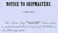 | Details | Steam Tug Agency | 1856 |
| Rate Sheet and Invoice for Maltese Steam Tug Dragon |
|
Steam Tug Agency |
|
| 1856 |
| LOC:0 |
| $260.00 | Steam-Tug-Agency | Rate-Sheet-and-Invoice-for-Maltese-Steam-Tug-Dragon | Fascinating piece of mid-nineteenth century Maltese maritime history. Tugboat rate sheet with manuscript invoice for towing services performed by the steam tug "Dragon". The Dragon was a 40 horsepower paddle-wheel steam tug operating out of the port of Valetta, Malta, then a part of the British Empire.
<div class="indenttextblock">
…. "the arrival of steam propulsion opened a new chapter in the history of Maltese maritime trade. The port of Valletta became an important bunkering station and this position was further strengthened with the opening of the Suez Canal in 1869.<br>
…<br>
The ‘Dragon’ was one of the earliest steam tugboats operating in the Grand Harbour and Marsamxett. She
arrived at Malta from Newcastle early in December 1855 and on arrival she was immediately placed in service under the command of Captain William Donkin. A circular distributed to the commercial community by the owners of the ‘Dragon’ makes interesting reading. ( First International Merchant Bank 2002 Annual Report. <a href="https://www.google.com/url?sa=t&rct=j&q=&esrc=s&source=web&cd=6&ved=0ahUKEwjY7uSp9s_NAhXC5CYKHW1kCl4QFgguMAU&url=http%3A%2F%2Fwww.fimbank.com%2Ffile.aspx%3Ff%3D654&usg=AFQjCNFNxUU_FaX6kLpA-GcOiolsVGSm6g&sig2=K9DkC_MLyepdArQHbbV5WQ&cad=rja " target="_blank">Internet</a>
</div>
<br>
<em>"NOTICE TO SHIPMASTERS
<br></br>
The steam Tug "Dragon" tows vessels in and out and about the ports of Valetta at the following rates: …<br>
…<br>
… The signal to be used by vessels coming from seaward or in port requiring the tug's services will be to hoist the national ensign at the fore topgallant or royal mast head. Special services subject to agreement with John C. Swift, ship-chandler Malta or Capt. William Donkin on board."</em> |
| 458 |  | Details | Wilson, G.W. | 1857 |
| H.M.S. Impregnable |
|
Wilson, G.W. |
|
| 1857 |
| LOC:0 |
| $150.00 | Wilson--G-W- | H-M-S--Impregnable | Attractively framed by branches, this stereoview of the British second-rate ship of the line H.M.S. Impregnable from 1857 was created by Scottish photographer G.W. Wilson. All three gun decks are clearly visible as the ship sits at anchor in Hamoaze, near Plymouth, England. The Impregnable, a close copy of Nelson's "Victory" was launched in 1811 and later refitted as a guard-ship. She saw action in the bombardment of Algiers in 1816. From 1862 to 1886 the Impregnable was used as a training ship for British naval cadets.<BR> </BR>
With two cancelled U.S. revenue stamps on the verso. Number 313. Manuscript annotation on verso reads: "Rundlet 27". |
| 4718 |  | Details | Blunt, George W. | 1860 |
| Rare trade card- NY Pilot Boat 11 the George W. Blunt |
|
Blunt, George W. |
|
| 1860 |
| LOC:41 |
| $500.00 | Blunt--George-W- | Rare-trade-card--NY-Pilot-Boat-11-the-George-W--Blunt | Very rare and desirable antebellum trade card for Pilot Boat No. 11, the George W. Blunt (G.W. Blunt) of the New York harbor pilots. Named after one of three sons of Edmund Blunt, who was one of the most important figures in U.S. nautical cartography during the first half of the 19th century. This scarce Civil-war era artifact should have strong interest for collectors of 19th-century maritime nautical cartography, the history of New York harbor, or civil-war era nautical artifacts.
<br></br>
The George W. Blunt was a 76 ton wooden schooner for the New York Pilot Commission, acquired by the U.S. Navy and commissioned in December 1861. She served with the South Atlantic Blockading Squadron through mid 1864. This trade card dates to before 1861 when the Pilot Commissioners' office was located at 69 South Street, Corner of Pine Street. In 1875 the G. W. Blunt was lost on the Long Island shore about thirty miles from the Sandy Hook light vessel (1).
<br></br>
G. W. Blunt, the third son of Edmund M. Blunt was born in Newburyport, Mass in 1802 (2). The elder Blunt prepared and composed a work entitled "The American Coast Pilot" which described every port on the coast of the United States, the publication went through 18 successive editions beginning in 1796.
<br></br>
George W. Blunt served as a member of the New York Board of Pilot Commissioners, from 1845 to 1877. and owned the New York pilot boat Moses H. Grinnell (3). At his death G.W. Blunt held the office of Secretary of the Board of Pilot Commissioners.
<br></br> <i>
(1) Pilot lore; from sail to steam. United New York and New Jersey. Sandy Hook Pilots Benevolent Associations. 1922. Online.
</BR>
(2) http://nyscu.org/Archives/
</BR>
(3) Cunliffe, Tom. ed. Pilots: Pilot Schooners of North America and Great Britain. Wooden Boat Publications. Brooklin, Maine. 2001.
</i> |
| 1110 |  | Details | Imagerie de P. Didion | 1860 |
| Mid-Nineteenth Century French Fencing Certificate |
|
Imagerie de P. Didion |
|
| 1860 |
| LOC:9 |
| $250.00 | Imagerie-de-P--Didion | Mid-Nineteenth-Century-French-Fencing-Certificate | "Diplôme d'une spécialité d'escrime". Two-color lithographed and hand-colored blank fencing certificate or diploma. In this certificate the combatants are using sabre-like weapons with no hand guard, perhaps wooden practice weapons . Similar martial-arts certificates were issued for a number of French sword and stick fencing ( escrime ) styles. Common all these 19th century 'brevet' is that onloookers, presumably including signatories to the certificate, view the mock combat in military regalia surrounded by emblems and mottos of the French state. Other simlar brevet exist for pointe ( foil ), bâton, and canne.
<br></br>
Publisher's attribution reads: Imagerie de P. Didion, a Metz. Dehalt Successeur. |
| 993 |  | Details | Anonymous | 1866 |
| Steamboat Bill of Lading for Valence Plantation |
|
Anonymous |
|
| 1866 |
| LOC:1 |
| $500.00 | Anonymous | Steamboat-Bill-of-Lading-for-Valence-Plantation | Rare post civil war shipping document, a "Bill of Lading", for the steamboat <b>Belle Ida</b> to transport items from New Orleans, Louisiana to Valence Plantation, along Bayou Lafourche, in Assumption Parish. <b>Valence Plantation</b> was most likely located near the current-day town of Supreme, just a few miles south of the well-known Madewood Plantation and Naploeonville, Louisiana. Dated within to February 9th, 1866. The bill of lading was filled in by hand at time of shipping and is addressed to J.B. Savage, Valence Plantation, Bayou Lafourche.
<br></br>
Bayou Lafourche has not been navigable from the Mississippi River since 1905 when a dam was built at Donaldsonville, La. but prior to that time the waterway served as an important commercial artery.
<br></br>
The Belle Ida was likely a stern-wheel steamboat built in 1861 (Wooldridge Steamboat List. <a href="https://www.umsl.edu/mercantile/collections/pott-library-special-collections/assets/pdf/collections/Woold_Ridge_Steamboat_list.pdf" target="_blank">Internet </a>). With a stock logo of a side-wheel steamboat by T. Fitzwilliam, Stationer and Printer, 76 Camp Street, N.O.
<br></br>
Symonds, Courtney and Co. were Tobacco Factors and General Forwarding and Commission Merchants located at No. 35 Natchez Street, New Orleans, LA. With a glued 2 cent stamp within. Addressed on verso.
<br></br>
The items shipped from New Orleans by Symonds Courtney and Co. included:
<ul style="list-style-type: none;">
<li>1 sack of harnesses</li>
<li>1 bundle of bridles</li>
<li>5 cases of sundries</li>
<li>10 head of mules</li>
<li>1 horse</li>
<ul/> |
| 226 |  | Details | Helffricht, William | 1872 |
| Helffricht Trade Card - Philadelphia |
|
Helffricht, William |
|
| 1872 |
| LOC:14 |
| $25.00 | Helffricht--William | Helffricht-Trade-Card---Philadelphia | Scarce, small 19th-century antique nautical trade card or stamp for <b>William Helffricht's</b> NAUTICAL STORE, in Philadelphia, Pennsylvania. Helffricht sold charts, nautical books, and nautical instruments from their Front Street location.
<br></br>
From the "American Ephemeris and Nautical Almanac" for the year 1873. An item for collectors interested in maritime, nautical, or cartographic Victorian-era trade cards. |
| 398 |  | Details | Freeman, Josiah | 1873 |
| Bark Ashore at Surfside |
|
Freeman, Josiah |
|
| 1873 |
| LOC:14 |
| $220.00 | Freeman--Josiah | Bark-Ashore-at-Surfside | Stereoview photo by Nantucket photographer Joseph Freeman of the sailing bark Minmaneuth aground near Miacomet Pond on Nantucket's south shore. The vessel was enroute from Rio de Janiero to Boston with 4000 bags of coffee when she came ashore. The Minmaneuth was lightened of its load and refloated. The grounding had a positive result in that it prompted construction of a lifesaving station at Surfside beach. The stereoview shows passengers, shaded by parasols, sitting atop bags of coffee as they wait for the rest of the cargo to be unloaded. <BR> </BR>
The Nantucket Historical Association describes Freeman as the first of three great 19th century Nantucket photographers including Henry Wyer and Harry Platt. Josiah Freeman first opened a shop with David Coffin on the island in 1864 and remained in business until retirement in 1892. ( Historic Nantucket, Vol 35, no. 2 (Oct. 1987), p. 12-14) |
| 388 | 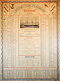 | Details | Bell, Richard | 1877 |
| Cruise of the U.S. Flagship Richmond |
|
Bell, Richard |
|
| 1877 |
| LOC:0 |
| $450.00 | Bell--Richard | Cruise-of-the-U-S--Flagship-Richmond | Large antique lithographed naval poster, a memento from the Atlantic and Pacific cruise of the U.S. <b>wooden steam-sloop Richmond</b> during 1872 to 1877. This poster-sized lithograph documents the crew and ports of call for the Richmond from the time it was put on commission at the Philadelphia Navy Yard on November 18, 1872 until it was decommissioned at the Boston Navy Yard in September 1877. <BR> </BR>
The Richmond had a long history of heroic service from the time it was launched in 1860. The sloop saw much action during the Civil War as part of the <b>Gulf Blockading Squadron</b> at the head of passes in the Mississippi River. The sloop was damaged during several engagements including an attack by David Farragut's squadron against Mobile bay, and an attack on Port Hudson. The valor of the crew on that vessel resulted in awards of the Medal of Honor to 32 marine guard and crew members, more than any other Union vessel in the Civil War. <BR> </BR>
Lists the crew, officers, and marine guard by name and rate. The print also contains a description of the ship's armaments and statistics: 259 feet length overall, draft 17.6 feet, engine, and much more. <BR> </BR>
We have been unable to locate another copy anywhere of this print that was apparently designed as a souvenir for the ship's crew. Probably very few copies were printed as the officers, marine guard and crew totaled only about 300.<BR> </BR>
Bottom section lists the numerous ports visited during the entire cruise of 60,583 1/4 miles with both arrival and departure dates. The cruise included a transit of the Strait of Magellan and visits to San Francisco and many other Pacific ports of call on the west coast of South and Central America. Compiled by Richard Bell, Yeoman. Printed by Rand, Avery and Company. Boston.<BR> </BR> |
| 1276 |  | Details | Philip. George | 1880 |
| Antique trade card for publishers George Philip and Son, London |
|
Philip. George |
|
| 1880 |
| LOC:0 |
| $165.00 | Philip--George | Antique-trade-card-for-publishers-George-Philip-and-Son--London | Large 19th-century <b>trade card</b> ca. 1880 for <b>George Philip & Son Ltd.</b>, London, England, one of the oldest publishers in the United Kingdom. This trade card promotes Philips' map design capability and printing technology: "MAPS SPECIALLY PREPARED FOR ALL PURPOSES" and "For Ideal Advertising. Philips' Map Schemes always attractive, useful, and profitable. Colour printing by modern methods."
<br></br>
The two-color card image shows the Isle of Wight with the Solent and Spithead.
<br></br>
George Philip and Son, a British publishing house, one of the oldest in the United Kingdom. The company, specializing in maps and atlases, was founded in 1834. In 1852 a London house was opened at 32 Fleet Street, to promote sales of the firm's geographical and educational publications at home and abroad. The firm grew rapidly, helped by new technology — notably power-driven lithographic presses and the machine-colouring of maps. <a href="http://www.gracesguide.co.uk/George_Philip_and_Son" target="_blank">(Online)</a> |
| 1240 | 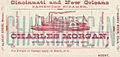 | Details | Cincinnati and New Orleans Passenger Line | 1880 |
| Trade card for Steamboat Charles Morgan |
|
Cincinnati and New Orleans Passenger Line |
|
| 1880 |
| LOC:0 |
| $180.00 | Cincinnati-and-New-Orleans-Passenger-Line | Trade-card-for-Steamboat-Charles-Morgan | Very interesting and rare antique trade card for the side-wheel <b>steamboat Charles Morgan</b> of the Cincinnati and New Orleans Passenger Line. Built in 1873 and burned in Cincinnati in 1886, the Charles Morgan is well known for having Samuel Clemens a.k.a. Mark Twain as a passenger in 1882 when Clemens took a nostalgic tour to revisit places along the Mississippi River that he had visited in his previous occupation as a riverboat pilot.
<br><br/>
Front of the card contains an image resembing the steamer Charles Morgan. Verso contains the names and distances for approximately 100 of the steamboat stops along the route from Cincinnati to New Orleans, a total. distance of 1440 miles.
<br><br/>
The Charles Morgan was named for its owner, shipping tycoon Charles Morgan (1795-1878). Morgan moved to New York City at the age of fourteen and began a ship chandlery and import business which lead to investments in merchant shipping and ironworks and to management of several lines of sailing and steam packets trading with the South and the West Indies. He was also both partner and rival of Cornelius Vanderbilt in attempts to establish an isthmian transit across Nicaragua in the 1850s.
<br><br/>
Morgan City, Louisiana was named after Charles Morgan. |
| 7948 | 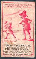 | Details | Cosgrove, John | 1880 |
| Trade Card for John Cosgrove Poydras Market New Orleans |
|
Cosgrove, John |
|
| 1880 |
| LOC:41 |
| $150.00 | Cosgrove--John | Trade-Card-for-John-Cosgrove-Poydras-Market-New-Orleans | Antique trade card advertising for John Cosgrove, a wholesale and retail dealer in fish, turtle, shrimps, crabs, pompano, red fish, snapper, and other seasonal fish at Poydras Market in New Orleans. Date is estimated as circa 1880.
<br><br>
The Poydras Market was a major public food market in 19th-century New Orleans, strategically located on Poydras Street near the Mississippi River and just west of the French Quarter. It was part of a network of municipal markets established to supply the city’s growing population with fresh produce, meats, and seafood. Its proximity to the riverfront made it an ideal site for offloading goods brought in by boat, especially the bounty of the Gulf—shrimp, crabs, pompano, redfish, turtle, and snapper were staples of the stalls.
<br><br>
The market was a bustling commercial hub where independent vendors, such as John Cosgrove, rented numbered stalls to sell seasonal goods. These vendors catered to a diverse clientele that included chefs, homemakers, and restaurateurs, all drawn by the variety and freshness of the offerings. The open-sided structure, typical of Southern markets, allowed for good airflow in the subtropical climate and fostered a lively, communal atmosphere filled with the sounds and scents of everyday commerce.
<br><br>
By the early 20th century, however, changes in transportation, refrigeration, and shopping habits began to erode the dominance of public markets. Poydras Market gradually declined and was eventually demolished—likely by the mid-20th century—as downtown New Orleans transformed into a modern commercial district. While the physical market is long gone, its name and legacy endure in the city’s culinary memory and in rare trade ephemera like this advertising card. |
| 210 |  | Details | Freeman, Josiah | 1880 |
| Stereoview- Nantucket. |
|
Freeman, Josiah |
|
| 1880 |
| LOC:14 |
| $100.00 | Freeman--Josiah | Stereoview--Nantucket- | Stereoview ca 1870-80 by Josiah Freeman of Nantucket. Scene looking out over Nantucket rooftops and gardens with a steam paddle wheeler rounding Brant Point Light House in the distance.<BR> </BR>
The Nantucket Historical Association describes Freeman as the first of three great 19th century Nantucket photographers including Henry Wyer and Harry Platt. Josiah Freeman first opened a shop with David Coffin on the island in 1864 and remained in business until retirement in 1892. ( Historic Nantucket, Vol 35, no. 2 (Oct. 1987), p. 12-14) |
| 4754 |  | Details | Haussmann, Georges-Eugène | 1880 |
| Urban Architect Haussmann Wife's Calling Card |
|
Haussmann, Georges-Eugène |
|
| 1880 |
| LOC:0 |
| $100.00 | Haussmann--Georges-Eugène | Urban-Architect-Haussmann-Wife-s-Calling-Card | Arguably, no one is more responsible for the distinctive Parisian street plan of today than urban architect Georges-Eugène Haussmann. This artifact is Haussmann's wife's ( Louise Octavie de Laharpe 1807-1890; m. 1838) calling card from the latter part of the 19th century. With manuscript notations to the recipient on the recto. |
| 134 |  | Details | Anonymous | 1882 |
| Track Chart Anchor Line Transatlantic Service |
|
Anonymous |
|
| 1882 |
| LOC:0 |
| $90.00 | Anonymous | Track-Chart--Anchor-Line-Transatlantic-Service | Small antique ship's track chart of the Atlantic Ocean produced by the Anchor Line shipping company and used by passenger "Bertie Brown" to track his progress on a Transatlantic cruise. Details the daily position on a voyage from Ireland to New York departing September 29, 1882. Document on card stock folds into 3 parts. Front cover lists vessels owned by Anchor Line with their tonnage. With a profile view of a steamer underway. Expands to 10"x6". |
| 1404 |  | Details | Negus, T.S and J.D. | 1886 |
| 19th Century Printers Plate for a Course Protractor |
|
Negus, T.S and J.D. |
|
| 1886 |
| LOC:0 |
| $550.00 | Negus--T-S-and-J-D- | 19th-Century-Printers-Plate-for-a-Course-Protractor | Extremely rare copper <b>relief-method</b> printing plate for a 19th century <b>Course Protractor</b> (Patent applied for) sold by T.S. and J.D. Negus. Dated within to Aug. 31, 1886.
<br><br/>
The plate contains a fancy fleur-de-lis at north and three levels of markings for courses comprising the full 32 point of the compass for example (moving clockwise from North) : "NbE" (North by East), "NNE" (North North East), "NEbN" (North East by North), "NE" (North East), "NEbE" (North East by East), and so on around the compass finishing with "NbW". <b>"Boxing the Compass"</b> was a basic skill of any sailor, being the ability to repeat all 32 points of the mariner's compass.
<br><br/>
Negus' catalog described the purpose of their Course Protractor:
<div class="indenttextblock">
<ul style="list-style-type: circle;">
<li>1st. Instead of Parallel Rulers to find on charts courses and bearings and positions from cross bearings.</li>
<li>2nd. As an inspection table, to turn compass courses into true courses and vice versa.</li></ul>
</div>
The Negus firm's 1899 illustrated catalog and price list advertises their trade as "Chronometer Manufacturers, Compass Adjusters and Navigation Warehouse. 140 Water Street, New York." Negus' catalog contains a compass-like "Improved Transparent Course Protractor".
<br><br/>
This antique copper plate plate would have been used to print 360 degrees of marks unto the paper or isinglass substrate used for the main body of the protractor. Isinglass is a kind of gelatin obtained from the air bladders of fish, especially sturgeon.
<br><br/>
Plate 6.5" square with 6" diameter circle. The copper plate is mounted to several wooden blocks for use in a printing press.
<a href="
https://library.si.edu/digital-library/book/illuscatnautopti00negurich" target="_blank">(Online p. 83) </a>
<hr>
</BR>
Call for additional 19th century Negus compass-card printing plate sizes, pricing and availability. |
| 1130 | 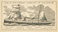 | Details | Ocean Steamship Company of Savannah | 1886 |
| Antique Trade Card for the Ocean Steamship Company of Savannah Georgia |
|
Ocean Steamship Company of Savannah |
|
| 1886 |
| LOC:41 |
| $270.00 | Ocean-Steamship-Company-of-Savannah | Antique-Trade-Card-for-the-Ocean-Steamship-Company-of-Savannah-Georgia | Rare trade card for the <b>Ocean Steamship Company of Savannah</b>. This antique trade card records the names of steamships and their sailing dates for this Savannah, Georgia based shipping company.
<br></br>
The Ocean Steamship Company of Savannah was founded in 1872 with passenger and cargo service between the cotton export port of Savannah, Georgia and the northern export ports of New York and Boston. This company was a subsidiary of the Central of Georgia Railway and was integral in moving cotton from Georgia and Alabama to New York and Boston, Massachusetts over the next seventy years.
<br></br>
Steamships listed on the card include:
<div class="indenttextblock">
<ul style="list-style-type: circle;">
<li>City of Augusta</li>
<li>Chattahoochee></li>
<li>Tallahassee></li>
<li>City of Savannah></li>
</ul>
</div>
Sailing dates listed on the back of the card are for routes from New York to Savannah, GA. during November 1886. |
| 1218 |  | Details | Anonymous | 1889 |
| Boston and Gloucester Steamboat Company pass for 1888 |
|
Anonymous |
|
| 1889 |
| LOC:0 |
| $70.00 | Anonymous | Boston-and-Gloucester-Steamboat-Company-pass-for-1888 | An antique Boston and Gloucester Steamboat Company annual pass for the year 1888. On green card stock. Issued as number 116. Valid until January 1, 1889. Ship's wheel decoration with the date "1888".
<br></br>
Boston and Gloucester Steamboat company began year round service in 1870 and continued operating between Boston and Gloucester until 1926 when they ceased operations. Steamboats from the line included the "Ella Knight", "George Chaffee", "City of Gloucester", and the "Cape Ann" a steel-hulled propeller driven vessel of 171 feet in length.
<br></br>
Text on the verso of this antique pass with rules and stipulation for use of the pass. |
| 1219 | 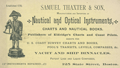 | Details | Thaxter, Samuel and Son | 1890 |
| Samuel Thaxter and Son, Boston, trade card |
|
Thaxter, Samuel and Son |
|
| 1890 |
| LOC:0 |
| $325.00 | Thaxter--Samuel-and-Son | Samuel-Thaxter-and-Son--Boston--trade-card | Scarce trade card for the Boston, Massachusetts firm of <b>Samuel Thaxter and Son</b>. Samuel Thaxter was an importer and manufacturer of nautical and optical instruments. Thaxter was the publisher of Eldridge's charts and coast pilots, and an agent for U.S. Coast Survey charts and books. During this period, they operated from a store at 125 State Street, Boston.
<br></br>
Samuel Thaxter and Sons sold sextants, charts, compasses, binnacles, levels, and other nautical items that occasionally are found on the antiques market today.
<br></br>
Absence of red overprinting of a new address at bottom of card suggests a date between 1880 and 1900. Verso carries the following historical information about the firms' genesis:<br></br>
<div class="indenttextblock">
<b>One Hundred Years Under One Sign</b>
<br></br>
(From the Boston Evening Transcript, February 2d 1873.)
<br></br>
In 1779 William Williams carried on the Nautical-Instrument business in King, now State Street, having as a sign an image called "Admiral Vernon". In 1794 Samuel Thaxter, who married his niece, succeeded him and carried on the business in his own name thirty years. Then, taking his son a partner, the style of the firm was changed to S. THAXTER & SON, under which name it has continued the last fifty-one years at 125 State Street, corner Broad Street. Samuel Thaxter Cushing, grandson of S. Thaxter has been connected with the business thirty-eight years, and for the last thirty-three years, the only surviving partner. For all that time the "Admiral" with his quadrant has stood guard and stands guard now, on State Street, fit prototype of the smart little image displayed by Walter's uncle as chronicled in "Dombey & Son".</div> |
| 4801 |  | Details | Rathbun, Frank A. | 1890 |
| Early Cyanotype Advertisement for Rathbun's Wagon Jack and Wrenches |
|
Rathbun, Frank A. |
|
| 1890 |
| LOC:10 |
| $560.00 | Rathbun--Frank-A- | Early-Cyanotype-Advertisement-for-Rathbun-s-Wagon-Jack-and-Wrenches | A rare 19th-century <b>cyanotype print folk-art advertisement</b> ca. 1890 for F.A. Rathbun's wagon jack and wrenches. No other copy of any advertisement for Rathbun or his equipment is found online. The blueprint (cyanotype) photographic process, invented in 1842, was not adopted widely as a business document reproduction technology until after 1880.
<br></br>
With two cartoon-like drawings illustrating the "Worst Way" and the "Best Way" to change a wheel on a buggy or wagon (no mention of automobiles). The best way according to the author is Rathbun's Wagon Jack and Wrenches. Compliments of F.A. Rathbun Beloit, Wisconsin.
<br></br>
With an additional 3" x 7" cyanotype print of a large wrench labeled "F.A. Rathbun Beloit Wis."
<br></br>
The ad copy reads:
<div class="indenttextblock">
"Compliments of F.A. RATHBUN. BELOIT WIS. Manufactuer [sic] of his celebrated Wagon Jacks & Wrenches. By the use of which any one can grease thier [sic] wagon or buggy in less then one half the time required by the use of any other jack and wrench in the market without soiling hands or clothes. The pecular [sic] construction of the jack and manner in which it is used, recommmends its-self to all who know the trouble usually experienced with all jacks that have to be used under the buggy. This is the only jack that can be used at the end of the axle so that the wheel can be slid out on it for support. The 'wrench' also recommends itself to all who would avoid geting [sic] themselves greasy and dirty or straws and dirt on the nut to be scraped off or remain on to wear out the spindle. It is always ready. Never slips, and is quickly and easily operated. All who have used them recommed [sic] them to others. Liberal discount, to the trade and agents."
</div>
In April 1887 Frank A. Rathbun a machinist of Beloit Wis. assigned a patent he held on a wheeled scraper to F.W. Kimball of Milwaukee, Wis. However there is no mention of a patent on Rathbun's wagon jack. |
| 1232 |  | Details | Colby, C. H. | 1895 |
| Antique Cabinet Card of Steamboat Okeehumkee at Silver Springs, Florida |
|
Colby, C. H. |
|
| 1895 |
| LOC:0 |
| $175.00 | Colby--C--H- | Antique-Cabinet-Card-of-Steamboat-Okeehumkee-at-Silver-Springs--Florida | Large antique cabinet card of the steamer Okeehumkee docked at the Silver Springs' Florida landing, moss-covered trees in the background. The Okeehumkee, also known as "Queen of the Ocklawaha River," was a 84' x 21'river steamboat that provided transportation along Florida rivers in the late 19th century. The Okeehumkee was equipped with a paddle wheel positioned in the lower stern part of the boat which allowed it to traverse narrow and shallow rivers.
<br></br>
The steamer Okeehumkee was built in 1873 by Hubbard Hart, founder of the Ocklawaha Navigation Company's Hart's Line, at his East Palatka Hart's Point shipyard. It was named after a Native American chief from the area of the Ocklawaha lakes. The boat was outfitted with shutters on the windows to keep tree branches out and a livestock pen at the rear of the boat, on the upper deck. The boat was altered several times throughout its service lifetime. In 1893, a second deck of cabins was added. In 1919, Hart's Line ceased operation and the Okeehumkee was moored at Hart's Point shipyard in East Palatka.
<br></br>
In 1883 Lady Duffus Hardy published a <a href="https://books.google.com/books?id=-Iw-AAAAYAAJ&printsec=frontcover&dq=inauthor:%22Lady+Duffus+Hardy%22&hl=en&sa=X&ved=0ahUKEwjJvM-_nNHTAhXQZiYKHWdED4sQ6AEIJzAA#v=onepage&q&f=false" target="_blank">vivid account</a> of her trip aboard the Okeehumkee on the Oklawaha River from Silver Springs, Florida to Palatka. Lady Hardy relates how pine logs were burned in a large cauldron at the top of the vessel to provide illumination at night. "Now the blue flame flashes up to the great tree tops, then darts downward like a fiery serpent, and up some winding water lane, and for a second, a thousand weird forms float before our eyes, and change and fade and melt into nothingness." |
| 1168 |  | Details | Simpson, Thomas I. | 1895 |
| Antique Thomas I. Simpson Nautical Hardware Catalog |
|
Simpson, Thomas I. |
|
| 1895 |
| LOC:0 |
| $165.00 | Simpson--Thomas-I- | Antique-Thomas-I--Simpson-Nautical-Hardware-Catalog | Antique nautical hardware catalog and price list for Thomas I. Simpson a company located at 94 John Street, New York. U.S.A. Factory at Lynbrook, Long Island. The back of the title page reads " MANUFACTURER OF Sail Makers', Awning Makers', Ship Chandlery and Marine HARDWARE.
<br></br>
Contains hundreds of useful drawings and references for collectors of nautical or whaling antiques. 272 pages plus index.
<br></br>
By Thomas I. Simpson, The wide range of inventory includes:
<div class="indenttextblock">
<ul style="list-style-type: circle;">
<li>Jib sheet blocks for rope strap (Oak or lignumvitae)</li>
<li>Never-sink cork jackets</li>
<li>Galvanized iron screws</li>
<li>Fishing smack signals</li>
<li>Harpoons and toggle irons</li>
<li>Boat cleats</li>
<li>Patent adjustable leg irons and handcuffs (Polished or nickel plated)</li>
<li>Wooden mast balls, gilded</li>
</ul>
</div>
Printed by W. J. PELL PRINT, 92 JOHN ST., NEW YORK. |
| 1405 |  | Details | Negus, T.S and J.D. | 1900 |
| Lot of 5 Antique Printers Plates for Compass Cards |
|
Negus, T.S and J.D. |
|
| 1900 |
| LOC:0 |
| $140.00 | Negus--T-S-and-J-D- | Lot-of-5-Antique-Printers-Plates-for-Compass-Cards | A lot of 5 rare metal <b>relief-method</b> printing plates for late 19th-century or early 20th century <b>compass cards</b> sold by T.S. and J.D. Negus. New York. These plates have diameters ranging between 4.75 to 2.25 inches. On some plates the engraver has replaced the "E" for East with "O" for Ost, the German word for East. These plates document Negus's participation in foreign sales of its compasses and other similar navigation instruments. One plate appears to be a variant of Negus' patented course protractor. The largest plate contains an attractive fleur-de-lis emblem at North. Each plate is tacked to a solid wooden block for use in letterpress.
<br><br/>
The Negus firm's 1899 illustrated catalog and price list advertises their trade as "Chronometer Manufacturers, Compass Adjusters and Navigation Warehouse. 140 Water Street, New York." Negus' 1899 catalog and price list contains pocket compasses, dry compasses, tell-tale and transparent compasses as well as a pelorous, a compass-like navigation device used by a ship's pilot for maintaining a bearing on a distant ship or shore-based object. <a href="
https://library.si.edu/digital-library/book/illuscatnautopti00negurich" target="_blank">(Online p. 83) </a>
<br><br/>
These printer's plates would have been used to print circular compass cards divided into points of the compass, degrees clockwise from north. A compass card, with magnets mounted below, would be suspended from a pivot within the compass so as to rotate freely. In their catalog, Negus' dry card compasses are offered with card sizes of 3", 4", 6.75", 7.75", and 9" at prices ranging from $4 to $20.
<hr>
</BR>
Call for additional 19th century Negus compass-card printing plate sizes, pricing and availability. |
| 135 |  | Details | Anonymous | 1902 |
| Track Chart Anchor Line American Mail Steamships |
|
Anonymous |
|
| 1902 |
| LOC:0 |
| $85.00 | Anonymous | Track-Chart--Anchor-Line-American-Mail-Steamships | Antique ship's track chart of Atlantic Ocean produced by the Anchor Line shipping company that was used by a passenger to track his progress on a Transatlantic cruise. Details the daily latitude and longitude on a 2689 mile voyage of the SS Anchonia between New York and Glasgow on Aug 9th - 19th, 1902. Daily position plots indicate a more northerly path than usual. <BR> </BR>
Document on card stock folds into 3 parts. Front cover lists vessels owned by Anchor Line with their tonnage and shows a frontal view of a steamer underway. Expands to 10"x6" |
| 289 |  | Details | Providence, Fall River and Newport Steamboat Co. | 1904 |
| Brochure- Providence , Fall River and Newport Steamboat Co |
|
Providence, Fall River and Newport Steamboat Co. |
|
| 1904 |
| LOC:0 |
| $165.00 | Providence--Fall-River-and-Newport-Steamboat-Co- | Brochure--Providence---Fall-River-and-Newport-Steamboat-Co | Scarce antique eight-page brochure and map for the Providence, Fall River and Newport Steamboat Company, 136 Dyer Street, Providence, Rhode Island. This small brochure, dated internally to 1904, contains time tables, descriptive information on each port and sightseeing tips and advertisements from local businesses and resorts.
<BR> </BR>
Contains a list of the eight steamers comprising the company's fleet and their passenger capacity:
<div class="indenttextblock">
<ul style="list-style-type: circle;">
<li>Mount Hope - 2000 persons</li>
<li>Warwick - 2000 persons</li>
<li>Richard Borden - 1500 persons</li>
<li>City of Newport - 1100 persons</li>
<li>Favorite - 1100 persons</li>
<li>What Cheer - 750 persons</li>
<li>Squantum - 850 persons</li>
<li>Baltimore - 500 persons</li>
</ul>
</div> |
| 5064 |  | Details | Florida East Coast Hotels | 1908 |
| Scarce Hotel Sevilla, Havana Cuba Point of Sale Advertisement |
|
Florida East Coast Hotels |
|
| 1908 |
| LOC:400 |
| $325.00 | Florida-East-Coast-Hotels | Scarce-Hotel-Sevilla--Havana-Cuba-Point-of-Sale-Advertisement | Rare point-of-sale advertising placard for the opening of Hotel Sevilla in Havana, Cuba. 1908. With information and six pasted photographs for Hotel Sevilla. Two sides on hard stock with red edging. Verso with two large photographs for Hotel Champlain.
<br></br>
The Hotel Sevilla was scheduled to open on December 1st, 1908 under the management of A.E. Dick:
<div class="indenttextblocksingle">
"A new modern hotel with every convenience situated near the park and Prado, Expensively furnished throughout, delightfully comfortable, lofty ceilings, tiled floors, open courts, balconies, every room with a bath and other modern conveniences, electric lights, bells and telephones in every room."
</div> |
| 681 |  | Details | Deering, G.G. | 1919 |
| Launch Invitation for the ghost ship Carrol A. Deering |
|
Deering, G.G. |
|
| 1919 |
| LOC:0 |
| $375.00 | Deering--G-G- | Launch-Invitation-for-the-ghost-ship-Carrol-A--Deering | Original folding invitation and menu for the launching of the famous ghost ship Carroll A. Deering in April, 1919. On January 29, 1921 the 5 masted schooner grounded on the outer shoals of Cape Hatteras. The ship was abandoned and the crew, logbooks and navigational equipment were never found. The case of the Carroll A. Deering is one of the top maritime mysteries, along with that of the Mary Celeste.
<br></br>
According to an online article by the National Park Service: <div class="indenttextblock">"On January 29, 1921, the Carroll A. Deering was making a return trip to Hampton Roads, Virginia from Barbados when she passed the Cape Lookout Lightship. According to the lightship keeper, the crew was milling about and a crewman, who did not look or act like an officer, reported that the ship had lost its anchors. The following day, the ship passed the SS Lake Elon southwest of the Diamond Shoals Lightship at approximately 5:45 pm. The Deering seemed to be steering a peculiar course. This was the last report of the ill-fated Deering before she was found run aground and abandoned. At 6:30 am on January 31st, C.P. Brady of the Cape Hatteras Coast Guard Station spotted a five-masted schooner in the morning light, aground and helpless on the shoals…. Upon investigating the ship, it was discovered that all personal belongings, key navigational equipment, certain papers, and the ship’s anchors were missing. Furthermore, food was laid out as if in preparation for a meal. But there was no sign of the crew.
Source: http://www.nps.gov/caha/historyculture/theghostship.htm</div>
<br>
Purchased in 2013 with other Deering memorabilia. Dated April 4, 1919. Cover contains the colored emblem of the G.G. Deering Company flag. Interior contains details of the launching of the Carroll A. Deering including the name of William Merritt, Master and a menu of the lunch served to guests at King Tavern in Bath, Maine. |
| 6563 |  | Details | Deering, G.G. | 1919 |
| Painting on Gold Leaf Ship Marie Sophie of Falmouth |
|
Deering, G.G. |
|
| 1919 |
| LOC:0 |
| $975.00 | Deering--G-G- | Painting-on-Gold-Leaf-Ship-Marie-Sophie-of-Falmouth | Painting on Gold Leaf of the Schooner Ship Marie Sophie of Falmouth on Masonite and housed in an early frame (painted tan). Original brass hangers. Seller noted: "Unsigned but I believe this was done by Carroll A. Deering son of the owner of the G.G. Deering Shipyard at Bath, Maine (later Bath Iron Works)."
<br></br>
Purchased in 2013 with other Deering memorabilia from 1919.
<br><br>
According to an online article by the National Park Service about the ghost-ship Carroll A. Deering (l. 1919). <div class="indenttextblock"> On January 29, 1921, the ship was making a return trip to Hampton Roads, Virginia from Barbados when she passed the Cape Lookout Lightship. According to the lightship a crewman, who did not look or act like an officer, reported that the ship had lost its anchors.
<br><br>
This was the last report of the ill-fated Deering before she was found run aground and abandoned. At 6:30 am on January 31st, C.P. Brady of the Cape Hatteras Coast Guard Station spotted a five-masted schooner in the morning light, aground and helpless on the shoals…. Upon investigating the ship, it was discovered that all personal belongings, key navigational equipment, certain papers, and the ship’s anchors were missing. Food was laid out as if in preparation for a meal. But there was no sign of the crew.
Source: http://www.nps.gov/caha/historyculture/theghostship.htm</div> |
| 6781 | 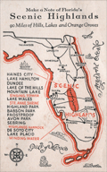 | Details | The Scenic Highlanders, Inc. | 1930 |
| Advertising Map Note Card for Florida's Scenic Highlands |
|
The Scenic Highlanders, Inc. |
|
| 1930 |
| LOC:14 |
| $75.00 | The-Scenic-Highlanders--Inc- | Advertising-Map-Note-Card-for-Florida-s-Scenic-Highlands | Florida ephemera advertising map / note card promoting Florida's Scenic Highlands. Produced by The Scenic Highlanders, Inc. Lake Wales, Florida (no online information is available about the firm). Florida's Scenic Highlands included the towns of Haines City, Lake Hamilton, Dundee, Lake of the Hills, Lake Wales, Highland Park, Babson Park, Frostproof, Avon Park, Sebring, and Lake Placid.
<br><br>
<div id="6781" align="center">
<a title=""></a>
<img id="6781" src="/ZoomifyImages/SC_6781/SC_6781_400x300.jpg" alt="Florida ephemera advertising map note card for Florida's Scenic Highlands." width="340"/> <br><br> <font size="-2">Florida Highland's Map</font>
</div><br>
Address for further contact "The Scenic Highlanders, Inc. Lake Wales, Florida" lacks a telephone number and an address code thus early. Undated but ca. 1925 - 1930. Statement at top of the maps urges the reader to "Make a note of Florida's Scenic Highlands 90 miles of hills, lakes, and orange groves." |
| 5090 | 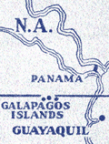 | Details | Diamond Match Company | 1942 |
| Galapagos Islands survey by U.S.S. Bowditch match book cover |
|
Diamond Match Company |
|
| 1942 |
| LOC:13 |
| $40.00 | Diamond-Match-Company | Galapagos-Islands-survey-by-U-S-S--Bowditch-match-book-cover | Scarce matchbook cover for the 386-foot U.S. Navy survey vessel U.S.S. Bowditch with an index map for their cruises of 1942-1943 to the Galapagos Islands, a part of Chile. Manufactured by the Diamond Match Company N.Y.C.
<br></br>
The USS Bowditch (AG 30) was first launched in 1929 at Copenhagen, Denmark, as the passenger ship Santa Inez. The Bowditch was outfitted as a surveying vessel and commissioned on 1 July 1940, with Commander E. E. Duval in command.
<br></br>
Departing Norfolk on 9 January 1942, the U.S.S. Bowditch steamed south to conduct surveys of the waters between Panama and Colombia, off the Galápagos Islands, and off the Cocos Islands in Costa Rica.
<br></br>
The following U.S. Navy charts were based on surveys conducted by the U.S.S. Bowditch in 1942 and 1943:
<div class="indenttextblocksingle">
<ul style="list-style-type: circle;">
<li># 5936 Approaches to Bahia Bartago, Archipielago de Colon (Galapagos Islands). 1942.</li>
<li># 5921 Eastern Approaches to Canal de San Salvador, Archipielago Colon (Galapagos Islands). 1943.</li>
<li># 5931 Western approaches to Canal Bolivar, Archipielago de Colon (Galapagos Island). 1942.</li>
<li># 5920 Isle Baltra, Archipielago de Colon (Galapagos Islands). 1942.</li>
<li># 5959: Golfo de Guyaquil. 1943.</li>
</ul>
</div>
The USS Bowditch was decommissioned in January, 1947 |
| 4806 |  | Details | Wilcox and Follett Co. | 1944 |
| Advertisement for Octovue Map on Pitner's Projection |
|
Wilcox and Follett Co. |
|
| 1944 |
| LOC:88 |
| $350.00 | Wilcox-and-Follett-Co- | Advertisement-for-Octovue-Map-on-Pitner-s-Projection | Scarce color brochure from 1944 explains and promotes Wilcox and Follet Co's Octovue map, their <b>New Air Age Educational -- Indispensable! WORLD MAP.</b> All on one single folding sheet printed front and back with 8 pages total in color. Folded size 5" x 8".
<br></br>
The Octovue map was one of the few maps to use the Pitner map projection. According to this brochure with the Pitner projection:
<div class="indenttextblock">
"The globe is divided into eight uniform spherical triangular sections: four North and four South of the equator…. each transposed onto a flat surface. … the first map ever made to transpose the round world onto a flat sheet without distortion or exaggeration of shapes, sizes, and distances."
</div>
<br></br>
Last page details what the U.S. Coast and Geodetic Survey in <i>Elements of Map Projections</i> consider to be the "Ideal Map" and provides reasoning for consideration of the Octovue map over all others.
<br></br>
Copyright 1944 by L.E. Pitner. Brochure edited by Harold B. Ward Ph.D. F.R.G.S. |
| 5194 |  | Details | Pitner, L. E. | 1944 |
| Illustrated Octovue Map on Pitner's Projection |
|
Pitner, L. E. |
|
| 1944 |
| LOC:53 |
| $350.00 | Pitner--L--E- | Illustrated-Octovue-Map-on-Pitner-s-Projection | Rare and unusual world map on the Pitner projection. First edition. Illustrated with hundreds of small drawings of flora, fauna, native tribes, buildings, transportation and landmarks. With 5 inset maps on the Mercator and other more common projections. Card covers with map still attached.
<br></br>
The Illustrated World Octovue Projection Edited by Harold B. Ward Ph. D. F.R.G.S. Designed and Published by L.E. Pitner 229 W. Mineral Street, Milwaukee, Wis. Copyright November 3, 1944 by L.E. Pitner
The Octovue map was one of the few maps to use the Pitner map projection. The Pitner projection is explained as:
<div class="indenttextblocksingle">
"The globe is divided into eight uniform spherical triangular sections: four North and four South of the equator…. each transposed onto a flat surface. … the first map ever made to transpose the round world onto a flat sheet without distortion or exaggeration of shapes, sizes, and distances."
</div>
An earlier version of the Pitner projection map was published in 1943 on a single-sided sheet as the "Air Age Octovue Map of the World". Again edited by Ward with a 1943 copyright by Pitner. That version of the map lacks the illustrations and some of the map elements from the verso of our map are on the recto of the 1943 version.
<br></br>
The Pitner projection was similar to the Lambert Azimuthal Equal-area projection.
<br></br> |
| 4898 |  | Details | International Correspondence Schools | 1949 |
| Radio. Radio. |
|
International Correspondence Schools |
|
| 1949 |
| LOC:41 |
| $100.00 | International-Correspondence-Schools | Radio--Radio- | From "Radio and Electronics: Training for Today's Opportunities". A cover from an early mad-man era brochure that combines the iconography of cartography and of electronics with simple bold graphics to persuade readers to set their lives in a new direction through an electronics training course. Further, the user could fine-tune his education through careful selection of courses. Brochure of 32 pages published by International Correspondence Schools of Scranton, Pennsylvania. Content is careers, benefits, courses and subjects taught. With an inserted application form.
<br></br>
On the face of a what would be a radio dial, the artist has cleverly used familiar compass directions rather than the expected frequency indicators one would see on a radio. Jagged lighting bolts, used instead of rhumb lines, reinforce the impression of the single-word title "Radio". Overall, the message is "Radio and electronics can set your life in a new direction." That is a lot of words to describe what the graphic was intended to convey at a glance.
<br></br>
<div class="indenttextblock">
"... the strength of the ICS system lay in its ability to introduce, in relatively simple language, subjects that its students may have thought were beyond their intellectual reach and then build gradually to mastery of fields like electrical or chemical engineering. In essence, ICS and other correspondence schools attempted to demystify industrial technology and science, to bring them down from their pedestals at the same time that Americans were barraged by and frightened by technological advances and yearned to understand and embrace them."(Watkinson, James D. Education for Success: The International Correspondence Schools of Scranton, Pennsylvania. Penn. Mag of History and Biography. Vol CXX No. 4. October, 1996. P. 364.)
</div> |
| 6585 | 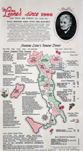 | Details | Mama Leone | 1960 |
| Large menu for Mama Leone's Restaurant in NYC |
|
Mama Leone |
|
| 1960 |
| LOC:57 |
| $225.00 | Mama-Leone | Large-menu-for-Mama-Leone-s-Restaurant-in-NYC | Large original menu from Mama Leone's restaurant in New York City circa 1960. Colorful pictorial map of Italy at center at center divided into administrative regions with each region promoting one or more of Mama Leone's wine offerings, for example Frecciarossa, Brachetto, Lambrusco, or Verdiccio or another of the available wines. Mama Leone's restaurant closed in 1994.
<br><br>
Inset photo of Mama Leone at top right. |
| 7927 |  | Details | Rambo, Ralph | 1971 |
| Santa Clara Valley sample map letter price list of Ralph Rambo |
|
Rambo, Ralph |
|
| 1971 |
| LOC:41 |
| $325.00 | Rambo--Ralph | Santa-Clara-Valley-sample-map-letter-price-list-of-Ralph-Rambo | A group of three artifacts that capture the spirit of California’s “Valley of Heart’s Delight” as seen through the eyes of Ralph Rambo (1894–1990)—the artist, humorist, and historian who chronicled old Santa Clara before it became Silicon Valley. Included is an autograph letter signed “Ralph Rambo” on his personal printed letterhead, dated circa 1971, in which the 76-year-old Rambo discusses his experience designing and selling maps as a “retirement pastime.” Written in his distinctive hand, the letter reflects his entrepreneurial wit and warm tone as he advises a fellow enthusiast on the economics of map publishing: “You are getting the very last of these maps... a handsome profit in map selling IF you have something GOOD with a wide appeal.”
<br><br>
Accompanying the letter are a salesman's' sample of Rambo’s pictorial map, -- Cartoon Pen and Inklings of the Old Santa Clara Valley — and Rambo's original price list for his illustrated works, all housed together in their original mailing envelope bearing Rambo’s Santa Clara return address. Together these three pieces form an evocative snapshot of a regional artist at work, combining correspondence, cartographic art, and period ephemera. An appealing and uncommon ensemble for collectors of California history, pictorial maps, or mid-century American illustration, they provide a glimpse into Rambo the entrepreneur. |