| | Thumbnail | | Creator | Date | Title / Author / Date / Location | Price | | | Description |
| 8064 |  | Details | Anonymous | 1959 |
| Mid century scarf Eglin Air Force Base Florida |
|
Anonymous |
|
| 1959 |
| LOC: |
| $365.00 | Anonymous | Mid-century-scarf-Eglin-Air-Force-Base-Florida | This scarce and colorful mid-20th-century souvenir textile celebrates Eglin Air Force Base, Florida, presenting the installation as a principal proving ground of American air power during the early Cold War. A pictorial map of Florida labeled “Air Proving Ground Command” anchors the design, surrounded by illustrations of jet aircraft, test pilots, target vehicles, and specialized facilities. The textile combines cartographic imagery with promotional aviation art, adapting a souvenir-scarf format widely used for U.S. Air Force bases in the 1950s.<br><br>
The aircraft depicted represent the forefront of U.S. Air Force technology in the supersonic transition era. Shown at mid-left is a B-52 Stratofortress, identifiable by its long straight wings and eight-engine configuration, symbolizing strategic bomber testing. At upper left appears a Lockheed F-104 Starfighter, recognizable by its needle-like fuselage and extremely short wings, while at upper right is a Convair F-102 Delta Dagger, distinguished by its pure delta wing and nose intake. Also depicted is a Republic F-84F Thunderstreak, a swept-wing fighter-bomber widely used in weapons and systems evaluation during the mid-1950s. Additional imagery of test pilots and supersonic tow targets reinforces Eglin’s testing mission.<br><br>
The dating of the textile is supported by both the aircraft selection and the prominent reference to the Climatic Hangar, a facility completed at Eglin in 1954 and widely promoted in subsequent years for extreme-environment testing. The inclusion of the F-102, operational from 1956, and the F-104, which entered U.S. Air Force service in 1958, establishes a firm late-1950s timeframe, while the F-84F reinforces a mid-to-late 1950s context. The absence of later aircraft types or space-age imagery associated with the 1960s further supports an early Cold War date. These elements place the textile most convincingly in the late 1950s, circa 1958 to 1960.<br><br> |
| 8058 | 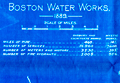 | Details | Boston Water Board | 1889 |
| Boston Water Works Blueprint Plan 1889 Sudbury Cochituate Mystic Water Supply Diagram |
|
Boston Water Board |
|
| 1889 |
| LOC:41 |
| $375.00 | Boston-Water-Board | Boston-Water-Works-Blueprint-Plan--1889-Sudbury-Cochituate-Mystic-Water-Supply-Diagram | |
| 8039 | 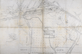 | Details | Mason, W.A. | 1887 |
| Unrecorded Manuscript Trace Cambridgeport Lands Frederick Lothrop Ames |
|
Mason, W.A. |
|
| 1887 |
| LOC:1401 |
| $2,750.00 | Mason--W-A- | Unrecorded-Manuscript-Trace-Cambridgeport-Lands-Frederick-Lothrop-Ames | A large, unrecorded pen and ink trace map on tracing cloth depicting lands on the Charles River Flats then held by the estate of Frederick Lothrop Ames (1) and associated owners, on the site now occupied by the Massachusetts Institute of Technology. The map was copied by William H. Whitney after Mason in the same month that the Massachusetts Legislature passed legislation that forced the cities of Cambridge and Boston to build the Harvard Bridge and share costs (2). Some portion of the map is attributed in pencil to a blueprint in Ames' possession, likely by W. A. Mason. Verso with the oval blue ink overstamp of William H. Whitney and index number 313.
<br><br>
The map was prepared in 1887, at a moment when the Charles River Embankment Company had begun construction of its granite seawall and was actively filling the Charles River Flats with dredged material from the river. It shows significant detail of the hydrography of the area including height in feet above low water at spring tide and the course of several small waterways including a detailed survey of Goff's Cove.
<br><br>Using the west line of the proposed Main Street extension, later realized as the Harvard Bridge, as a fixed boundary, and reading the notation on the mapped boundary, it appears Ames had already deeded lands west of this line to the Embankment Company. This drawing would have served as the working basis for negotiations over the remaining eastern portion of the Flats still under his ownership.
<br><br>
The sheet approximately covers the Charles River Flats from the navigable canal on the east to Goff's Cove on the west, and from the Boston and Albany Branch Railroad south to the planned 200 foot parkway along the riverbank. Detailed annotations at center record precise parcel boundaries totaling more than 2.3 million square feet and specify the fractional ownership interests of four parties, including Ames and the Charles River Embankment Company. Scale 80 feet to 1 inch.
<br><br> |
| 8030 |  | Details | Crowder, Cyril C. | 1935 |
| Crowder Variable Expansion Propeller Design Drawings |
|
Crowder, Cyril C. |
|
| 1935 |
| LOC:130 |
| $300.00 | Crowder--Cyril-C- | Crowder-Variable-Expansion-Propeller-Design-Drawings | These three manuscript drawings are a striking artifact of early aviation ingenuity, capturing a bold experimental idea that never left the drafting table. Their meticulously rendered telescoping blades, mechanical sections, and handwritten annotations reveal a level of detail and ambition rarely seen in surviving 1930s aeronautical work. As a display piece, it stands at the intersection of engineering art and aviation history: visually compelling, technically imaginative, and representing a line of research that was too impractical for its time or even for today. Framed, it becomes not just a engineering drawing but a cool conversation piece about the inventive spirit of early flight and the folly of some inventors.
<br><br>
Crowder's variable expansion propellor was designed by Cyril C. Crowder of Hollywood, California. No information is found online about the designer nor is any patent found for the design.<br><br> |
| 8016 |  | Details | Bower, N. E. | 1902 |
| Map of the U.S. Military Reservation, Fort Sill, Oklahoma Territory |
|
Bower, N. E. |
|
| 1902 |
| LOC:130 |
| $2,400.00 | Bower--N--E- | Map-of-the-U-S--Military-Reservation--Fort-Sill--Oklahoma-Territory | Unrecorded and important 1902 blueprint map documents the entire U.S. Military Reservation at Fort Sill, Oklahoma Territory, just five years before Oklahoma statehood and one year after the last Indian lands in Oklahoma opened for settlement. Compiled and drawn under the supervision of 2nd Lt. N. E. Bower, Corps of Engineers, the map was prepared for a Board of Officers convened on November 6, 1902 to review and verify the reservation’s boundaries, fences, roads, streams, and terrain. It presents the reservation in three components -- the Original Reservation, the Western Addition, and the Eastern Addition -- with detailed Public Land Survey System grids, contour lines, drainage, and the developed cantonment near Medicine Bluff Creek.<br><br>With the frontier gone and the cavalry mission fading, the fort shifted toward a new role as artillery units arrived, including the formation of the 39th Field Artillery Battery in 1902. This transition ultimately saved the fort from closure, and with the last cavalry regiment departing in May 1907, Fort Sill was firmly on the path to becoming the home of U.S. Army Field Artillery.<br><br>This map captures that transition with precision, drawing on General Land Office surveys, U.S. Engineer triangulations, earlier post maps, and contemporary field notes. Today the blueprint stands as an important visual record of the boundaries and landscape of one of the nation’s most significant western military posts, known as the later home of the Field Artillery School and the final residence of the Apache prisoners of war, including Geronimo.<br><br> |
| 7921 |  | Details | Nicholson, Francis | 1838 |
| Public squares, parks, and places in the city of New York |
|
Nicholson, Francis |
|
| 1838 |
| LOC: |
| $450.00 | Nicholson--Francis | Public-squares--parks--and-places-in-the-city-of-New-York | Maps of sixteen parks, on one sheet, covering various locales south of 125th Street in Manhattan, New York. Each park map gives dimensions and acreage, shows layout of park walkways and surrounding streets.
<br><br>
From D.T. Valentines manual. 1838. H.R. Robinson, Lith. Compiled and surveyed by Francis Nicholson, City Surveyor. August, 1838.
<br><br>
The 1838 “Manual of the Corporation of the City of New York” is considered a precursor volume to Valentine’s later annual manuals. Compiled when David Thomas Valentine (1841-1870) was Assistant Clerk of the Common Council, it served as an early attempt to assemble civic data, city charters, ordinances, and maps into a single reference work.
This 1838 edition predates the regular annual series and is not always listed among the later “official” manuals (which began in 1841), but bibliographers recognize it as the first appearance of Valentine’s work in this format.
<br><br> |
| 6833 | 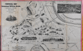 | Details | Van Ingen, Snyder, Gillett | 1876 |
| Pictorial Map of the International Exhibition Grounds First U.S. Worlds Fair |
|
Van Ingen, Snyder, Gillett |
|
| 1876 |
| LOC:86 |
| $975.00 | Van-Ingen--Snyder--Gillett | Pictorial-Map-of-the-International-Exhibition-Grounds-First-U-S--Worlds-Fair | Unrecorded variant edition "Pictorial Map of the International Exhibition Grounds", the first "World's Fair" held in the United States (1876) the same year the Statue of Liberty began construction in France. Along with the technological innovations and displays of American natural resources the Centennial Exhibition is notable as the location where two works of the renowned sculptor Frederic Auguste Bartholdi were on display- the right hand and torch of the Statue of Liberty and the Bartholdi Fountain.
<br><br>
<div class="indenttextblocksingle">
"In May of 1876, Bartholdi constructed the right arm bearing the torch, realizing it could stand alone if financing for the entire project failed. The torch’s display at the Centennial Exhibition in Philadelphia from August to November 1876 was a definite highlight with the fair’s approximately ten million visitors. Many scaled the 42-foot tall display for a fee of 50 cents."
</div><br> |
| 7932 | 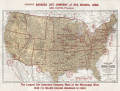 | Details | Kenyon Company | 1924 |
| Bankers Life Radio Map of the United States |
|
Kenyon Company |
|
| 1924 |
| LOC:41 |
| $300.00 | Kenyon-Company | Bankers-Life-Radio-Map-of-the-United-States | In 1924, American broadcasting was new enough to map. This Radio Map of the United States, engraved and published by the Kenyon Company of Des Moines with compliments of the Bankers Life Company, plots cities through their call signs. It is a document from the first radio boom, two years before the major networks formed, when individual stations defined the medium and listeners learned the geography of the air by call letters alone.
<br><br>
The design is simple and utilitarian. Time zone lines and numbered radio districts divide the country. Cities host their stations without decorative effects. The emphasis is informational: where a station is, what it is called, and how federal administration overlays the national map.
<br><br>
As advertising, the piece is direct. Bankers Life, calling itself the largest life insurer west of the Mississippi, links its presence to the spread of broadcasting. The sober printing and neat index give the map the tone of a directory while keeping the sponsor in view.
<br><br>
The call letters also tell a regulatory story. After 1912 the United States used the leading letters K, W, N, and A. For broadcasting, officials split K and W geographically and finalized the Mississippi River divide in 1923. New stations west of the river took K, those east took W, but early assignees kept their calls. That is why KDKA and KQV appear in Pittsburgh, east of the line. The 1924 sheet shows the new rule with the older exceptions still present.
<br><br>
A partial list of stations include:
<br><br> |
| 7868 |  | Details | Howell and Graves | 1925 |
| Muscle Shoals, Alabama City of Unlimited Opportunity |
|
Howell and Graves |
|
| 1925 |
| LOC:130 |
| $450.00 | Howell-and-Graves | Muscle-Shoals--Alabama-City-of-Unlimited-Opportunity | Muscle Shoals, Alabama, a small city nestled along the Tennessee River, is perhaps best known today for its outsized influence on American music. The iconic "Muscle Shoals Sound," born in the city's legendary recording studios, has left an indelible mark on genres ranging from soul and R&B to rock and country.
<br><br>
But a century ago, Muscle Shoals was the epicenter of a different kind of boom - one fueled by grand industrial ambitions and the promise of a brighter future.
<br><br>
In the 1920s, automotive pioneer Henry Ford set his sights on transforming the sleepy Alabama town into a bustling metropolis to rival Detroit (1). The centerpiece of this vision was the Wilson Dam, a hydroelectric marvel that would provide cheap, abundant power to fuel the growth of industry.
<br><br>
Sensing an opportunity, New York City developers Howell and Graves began heavily promoting Muscle Shoals as the "City of Unlimited Opportunity." This advertising brochure, circa 1925, with a rare birds-eye view map showcases their grand plans. The map, which stretches from Seven Mile Island to the Wilson Dam, depicts a thriving industrial landscape, with the Tennessee River winding majestically in the background.
<br><br>
At the time, nitrate plants were the region's biggest employers, and the promise of readily available electricity was expected to lure even more manufacturers to the area. Howell and Graves themselves invested heavily in the city's future, constructing the first City Hall, homes, and the Howell and Graves Jr. High School, which still stands today as a Board of Education building.
<br><br>
However, the grand vision for Muscle Shoals was not to be. Much of the infrastructure built by Howell and Graves went unused as the Great Depression stifled the city's growth. The promised industrial boom never materialized, and Muscle Shoals settled into a quieter existence.
<br><br> |
| 6860 |  | Details | Anonymous | 1926 |
| Unrecorded Pictorial Map of Nevada and Calendar |
|
Anonymous |
|
| 1926 |
| LOC:89 |
| $350.00 | Anonymous | Unrecorded-Pictorial-Map-of-Nevada-and-Calendar | A very fine pictorial advertising map of Nevada from the Virginia City Bank of Virginia City, Nevada. With a complete calendar for 1926 at bottom. Includes unused metal hanger at top. A rare survivor in excellent condition. Map size 9.5" x 12.5". Overall, about 12" x 23".
<br><br>
<div id="0" align="center">
<a title=""></a>
<img id="6860" src="/ZoomifyImages/SC_6860/SC_6860_detail1.jpg" alt="Unrecorded Pictorial Map of Nevada with Calendar from 1926" width="240"/> <br><br> <font size="-2">1926 Virginia City Bank Advertising Map</font>
</div><br>
Virginia City, Nevada, was a historic mining town that experienced a significant boom in the mid-19th century due to the discovery of the Comstock Lode, a large deposit of silver ore. By 1926, however, the city had long passed its heyday and was in a state of decline. In 1926, the population was estimated to be around 1,500 people, a far cry from the 25,000 residents during the height of the mining boom.
<br><br>
In the early 20th century Virginia City began to shift its focus towards tourism. Efforts were made to embrace, preserve and promote the town's rich mining history and Wild West character to attract visitors. This map reflects that sentiment. |
| 6848 | 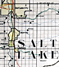 | Details | Utah Railway Chief Engineer | |
| Manuscript engineer's trace |
|
Utah Railway Chief Engineer |
|
|
| LOC:68 |
| $675.00 | Utah-Railway-Chief-Engineer | Manuscript-engineer-s-trace | Singular engineer's presentation trace for the Utah Railway. With this engineer's inked trace map the engineer's office could create numerous blueprint copies for distribution. Produced for the Utah Railway Chief Engineer's office and drawn by Elwood B. Stockman in Feb. 1927. Updated on June 1, 1934. Crisp artwork and lettering. Colors bright.
<br><br>
Shows Salt Lake City with the Salt Lake Base Line at upper left and extends well past Huntington, Utah at bottom right. Shows Park City.
<br><br>
The Utah Railway Company, originally named the Utah Coal Railway, was incorporated on January 24, 1912, and later shortened its name to Utah Railway in May of the same year. The company was founded to transport coal from its mines to Provo, Utah, due to an opening in the competitive landscape caused by dissatisfaction with the existing Denver and Rio Grande Railroad's service and route in the area.
<br><br>
During the 1930s, the Utah Railway faced challenges brought on by the Great Depression, which lowered demand for coal and, consequently, the railroad's business. However, the company managed to maintain its operations and even make some improvements during this difficult period. |
| 6814 |  | Details | Whitney, William H. | 1905 |
| Manuscript engineers trace map of Cambridgeport Massachusetts |
|
Whitney, William H. |
|
| 1905 |
| LOC: |
| $500.00 | Whitney--William-H- | Manuscript-engineers-trace-map-of-Cambridgeport-Massachusetts | Original manuscript trace map by the civil engineering firm of William H. Whitey, Boston. A traced pen and ink map on tracing cloth of an area in Cambridgeport, Massachusetts bounded by the Charles River to the south and Erie Street to the North and from Magazine Street at the west to roughly where Briggs Field now stands. This manuscript trace would have been used to create numerous blueprint copies for Whitney's clients. Whitney was a very early adopter of blueprinting to support his map-making and design business.
<br><br>
The map shows the location of the Boston University Bridge across the Charles River then under construction as well as the proposed location for an additional bridge downstream.
<br><br>
Includes Washington Square, a soap works of J. Reardon and Sons, Hastings Square, Morse School, Captain's Island Playground, Baptist home, and Lammson Memorial Building. By William H. Whitney, Boston Civil Engineer. |
| 6827 | 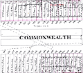 | Details | Fuller and Whitney | 1882 |
| Rare manuscript surveyors cadastral plan of Commonwealth Avenue in Boston Mass |
|
Fuller and Whitney |
|
| 1882 |
| LOC: |
| $850.00 | Fuller-and-Whitney | Rare-manuscript-surveyors-cadastral-plan-of-Commonwealth-Avenue-in-Boston-Mass | If you collect antique Boston paper or you are looking for an original, unique, one-of-a-kind gift for someone then consider this rare piece of Boston history:
<br><br>
This is a manuscript or hand drawn plan, a cadastral map of Commonwealth Avenue in Back Bay, Boston, Mass. from January, 1882. The map was the source map, a master map, a base map, for blueprint copies made around 1882 by the Civil Engineering firm of Fuller and Whitney who styled themselves "Back Bay Engineers". Fuller and Whitney tracked the owners name, lot width and lot number on Commonwealth during the fill and development of Boston's Back Bay in the latter half of the 19th century. Covers five blocks on Commonwealth Ave. between Dartmouth Street and West Chester Park, now called Massachusetts Ave.
<br><br>
Fuller and Whitey regularly used this master copy to publish beautiful blueprints tracking the progress of the Boston Back Bay project in the 1880's. To produce a blueprint they would lay a sheet of tracing paper across this master page and have a draftsman neatly trace and letter the plan in water-soluble ink. When that trace was complete they laid the trace across a sheet of unexposed blueprint paper and placed both sheets under the bright sun for several minutes to expose it, just like an old style contact photograph. The exposed print was then washed to develop it.
<br><br>
Although multiple blueprints may have been produced (I don't know of any) this is the only master manuscript source plan. They aren't making any more of these.
<br><br>
What a conversation piece! Includes notes from the engineers about the how the owner's names were put on the map and about lot widths.
<br><br>
Fuller and Whitey's document index file numbers 741 and 858.
<br><br>
<b>Other Boston manuscript maps are available. Contact us for more information.</b> |
| 6787 |  | Details | The Original Silicon Valley Map and Calendar | 1998 |
| Silicon Valley Historical Perspective Calendar Labeled Map |
|
The Original Silicon Valley Map and Calendar |
|
| 1998 |
| LOC: |
| $295.00 | The-Original-Silicon-Valley-Map-and-Calendar | Silicon-Valley-Historical-Perspective-Calendar-Labeled-Map | A sponsored calendar listing notable events for the 100 sponsoring firms in the Santa Clara Valley, Silicon Valley, California. Events range over a period from 1891 when Leland Stanford Jr. University opened near Palo Alto, through 1998 when Hexcel Corporation celebrated its 50th anniversary. Satellite photomap of Silicon Valley labeled with a numerical index sourced from the event table at right.
<br><br>
With large advertisement for the map's primary sponsor, Computer Literacy, that offered "computer and electronics books and related services to its customers through its retail stores and online."
<br><br>
Copyright 1997 by The Original Silicon Valley Map and Calendar a division of Amen International, San Jose California. Designed by OnTarget and printed by Benjamin Litho.
<br><br>
Other key events include:
<div class="indenttextblocksingle">
<ul style="list-style-type: circle;">
<li>1970 | Xerox Palo Alto Research Center is founded.</li>
<li>1976 | Wozniak and Jobs found Apple Computer.</li>
<li>1981 | IBM introduces the first IBM PC.</li>
<li>1987 | Microsoft PowerPoint introduced.</li>
<li>1995 | Sun Microsystems introduces Java.</li>
<li>1997 | Apple acquires Next with Steve Jobs.</li>
</ul>
</div> |
| 6784 |  | Details | Silicon Maps Inc. and Trestria Inc. | 2008 |
| 2008 Pictorial Calendar Map of Silicon Valley California |
|
Silicon Maps Inc. and Trestria Inc. |
|
| 2008 |
| LOC:11111 |
| $600.00 | Silicon-Maps-Inc--and-Trestria-Inc- | 2008-Pictorial-Calendar-Map-of-Silicon-Valley-California | Scarce "Classic Edition" Silicon Valley map and calendar copyrighted 2008 by Silicon Maps Inc. and Testria, Inc. Sponsored by Citrix, 4988 Great America Parkway, Santa Clara, California. Glossy finish as issued. |
| 6782 |  | Details | City Design | 1991 |
| Pictorial Advertising Map of San Jose, California |
|
City Design |
|
| 1991 |
| LOC:111111 |
| $1,600.00 | City-Design | Pictorial-Advertising-Map-of-San-Jose--California | Scarce pictorial advertising map of San Jose, California at the heart of Silicon Valley. A late 20th-century map produced and copyrighted by City Design of Pleasanton, California, in 1991. Names and phone numbers of sponsoring businesses appear in banners in the general vicinity of the business' address.
<br><br>
<div id="6782" align="center">
<a title=""></a>
<img id="6782" src="/ZoomifyImages/SC_6782/SC_6782_detail_1.jpg" alt="Detail from City Design map of San Jose, California. 1991." width="340"/> <br><br> <font size="-2">Detail from 1991 City Design map of San Jose, CA.</font>
</div><br> |
| 6760 |  | Details | Hillam, Corbin | 1981 |
| First Silicon Valley Advertising Pictorial Map |
|
Hillam, Corbin |
|
| 1981 |
| LOC:150 |
| $5,600.00 | Hillam--Corbin | First-Silicon-Valley-Advertising-Pictorial-Map | Original first pictorial advertising map locating "Silicon Valley". In 1981, artist Corbin Hillam unveiled a remarkable pictorial advertising map of Silicon Valley California, an artistic and commercial illustration that inspired a series of more than eighteen similar pictorial advertising maps created by various artists and publishers. Together the maps (1) provide an informative graphical time series of the firms active in Silicon Valley and the Santa Clara Valley Region in the late 20th century.
<br><br>
Analysis: The map is important as it is among the few remaining copies of Hillam's 1981 Silicon Valley map, created in the year IBM introduced its inaugural personal computer or PC, a groundbreaking event that sent ripples of innovation across the business landscape. IBM's PC served as a resounding testament, affirming the tangible reality of personal computing and establishing its enduring presence. 1981 was the year that personal computing won the corporate seal of approval.
<br><br>
Copyright Eclectibles, 1981.
<br><br>
<div id="6760" align="center">
<a title=""></a>
<img id="6760" src="/ZoomifyImages/SC_6760/SC_6760_detail_1.jpg" alt="First Silicon Valley Advertising Pictorial Map. Corbin Hillam. 1981. " width="340"/> <br><br> <font size="-2">Palo Alto detail from "Silicon Valley".</font>
</div><br><br> |
| 6775 |  | Details | Mikkelsen and Associates | 1991 |
| Silicon Valley Pictorial Advertising Map Spirit of Innovation |
|
Mikkelsen and Associates |
|
| 1991 |
| LOC:150 |
| $4,400.00 | Mikkelsen-and-Associates | Silicon-Valley-Pictorial-Advertising-Map-Spirit-of-Innovation | Pictorial map poster for Silicon Valley, California by Mikkelsen and Associates, 1991. The creator identifies San Jose as the "Capital of Silicon Valley." Very scarce in this version, lacking a calendar.
<br><br>
<div id="0" align="center">
<a title=""></a>
<img id="6775" src="/ZoomifyImages/SC_6775/SC_6775_detail_1.jpg" alt="Pictorial map poster for Silicon Valley, California by Mikkelsen and Associates, 1991" width="340"/> <br><br> <font size="-2"> Capital of Silicon Valley, San Jose, CA.</font>
</div><br>
The poster was commissioned and copyrighted by Access Global Inc. 1992 (1). With the San Francisco skyline visible at upper left, the poster map shows elevation views of local tech firm buildings and other businesses, each identified with the firm's name and logo. These include:
<br><br>
<div class="indenttextblocksingle">
<ul style="list-style-type: circle;">
<li>Mylex</li>
<li>Phase Two Industries</li>
<li>Synoptics</li>
<li>Hitachi Data Systems</li>
<li>Zilog</li>
<li>Sierra Semiconductor</li>
<li>Jabil Circuit</li>
<li>Photronics</li>
</ul>
</div>
(1) Access Global, Inc. Milpitas, California. Access Global, Inc. was incorporated in 1991. That firm's trademark was "Spirit of Innovation. |
| 6769 | 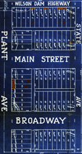 | Details | Milner, P. S. | 1925 |
| Blueprint map Industrial Plant Gate Addition Muscle Shoals Nitrate Plant 2 |
|
Milner, P. S. |
|
| 1925 |
| LOC:130 |
| $250.00 | Milner--P--S- | Blueprint-map-Industrial-Plant-Gate-Addition-Muscle-Shoals-Nitrate-Plant-2 | Scarce blueprint plat map for the Industrial Plant Gate Addition located near the main gate to the U.S. Government's Nitrate Plant #2 at Muscle Shoals, Alabama. Dated withing to April 27, 1925. The nitrate was used for producing gunpowder. An ugly reminder of the racism that was endemic one-hundred years ago is that one of the three building restrictions listed was "Caucasian Race Only."
<br><br>
Inset smaller-scale map of the greater Muscle Shoals district drawn by W. A. Dealy. The map shows the location of Nitrate Plants #1 and #2 in relationship to Sheffield, Florence, and Tuscumbia, AL.
<br><br>
Please see our other blueprint cadastral plat maps for the 1920's Muscle Shoals land boom from Keane Development Corp., Howell and Graves, and others. These proposed additions include Huston Heights, Lakeside Highlands, and Muscle Shoals Center. |
| 6750 | 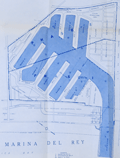 | Details | Nicholson, George F. | 1956 |
| Unrecorded Marina del Rey Economic Study |
|
Nicholson, George F. |
|
| 1956 |
| LOC:2001 |
| $950.00 | Nicholson--George-F- | Unrecorded-Marina-del-Rey-Economic-Study | Unrecorded, detailed analytical economic report "Marina del Rey Economic Study" produced March 5, 1956 by George F. Nicholson, C.E. Consulting Engineer.
<br><br>
A detailed report by Nicholson bound with transmittal letter and six-page summary from Nicholson to J.A. Lambie, Los Angeles County Engineer. Hard cover. 79 pages text. Table of Contents. Three maps. One site photograph. Four tables. Manuscript signature inside cover for Walt Petty.
<br><br>
Rare. No copy of this report is found anywhere online. |
| 6724 |  | Details | Perry, Heather "Herry" | 1930 |
| Rare Art Deco Imperial and International Communications Ltd Map Puzzle |
|
Perry, Heather "Herry" |
|
| 1930 |
| LOC:500 |
| $3,500.00 | Perry--Heather-"Herry" | Rare-Art-Deco-Imperial-and-International-Communications-Ltd-Map-Puzzle | <br></br>Bring a piece of British telecommunications history to your collection. This exquisite, complete, and rare Art Deco style puzzle map of the Imperial and International Communications (IICL) network ca. 1930 precedes McDonald Gill's Cable and Wireless Great Circle map by 15 years and features elegant characters representing the Anemoi, mythological Roman wind gods, and the Greek wind gods or Venti: Boreas, Zephyrus, Notus, Eurus, Aquilo, Favonius, Auster, and Vulturnus. Green lines indicate the undersea cables of the IICL, while dotted green lines signify IICL wireless transmissions.
<br><br>
<div id="0" align="center">
<a title="Perry's Telecom Map Puzzle"></a> <img id="3" src="/zoomifyimages/SC_6724/SC_6724_Detail.jpg" alt="Art Deco details from Herry Perry map puzzle for Imperial and International Communications Ltd, 1930, London." width="350"/> <br><small>Detail from Herry Perry's Art Deco IICL map puzzle, 1930.</small>
</div><br>
The map was designed by Herry Perry and manufactured as a promotional item for the IICL, by the Chad Valley Company, an eminent English toy manufacturer . The Chad Valley Company was active from 1860 to 1978. Its products ranged from high-quality soft toys, educational puzzles, board games, to construction sets.
<br></br>
In 1929, the Imperial Telegraphs Act paved the way for the formation of two new companies that would merge the various telegraph and wireless services within the British Empire and create a coordinated global communications network. Initially, IICL focused on expanding its services within the British Empire, but it eventually expanded its coverage to other regions like the Middle East, Africa, and Asia. IICL merged with Cable & Wireless Limited in 1934. Includes the intact original puzzle box.
<br><br>
Don't miss out on the opportunity to own a rare and remarkable piece of British telecommunications history - purchase this Art Deco map puzzle of the IICL network today. |
| 6687 | 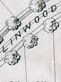 | Details | Olmsted, F. L. and Company | 1889 |
| F.L. Olmsted heliotype landscape plan Linwood Lynn Massachusetts |
|
Olmsted, F. L. and Company |
|
| 1889 |
| LOC:50 |
| $875.00 | Olmsted--F--L--and-Company | F-L--Olmsted-heliotype-landscape-plan-Linwood-Lynn-Massachusetts | Rare finely-detailed heliotype (1) plat and landscape plan by Frederick Law Olmsted for the Linwood development, in Lynn, Massachusetts, 1889. WorldCat lists only one copy, at Harvard. Heliotype Printing Co., Boston. R.R. Jones, del.
<br><br>
<div class="indenttextblocksingle">
"John Charles and Frederick Law Olmsted developed the Linwood subdivision on the estate of Philip Tapley, a hilltop property with views of striking features like Breed’s Pond and Lynn Harbor. With the site's steep topography, the pair faced challenges and had to make strategic design choices to maximize space on the hilltop plateaus. Plans show that roughly 218 lots were mapped to house large single-family homes. Unfortunately, Linwood was never developed (1).
<br>
</div>
<br>
In 1889, F. L. Olmsted designed Linwood, a neighborhood in Lynn, Massachusetts. The Linwood neighborhood was a unique project at the time, as it was one of the earliest examples of a planned suburban community. Olmsted was hired by the developers of the Linwood project, the Lynn Land Company, to design the landscape and street plan for the neighborhood. Olmsted's plan for Linwood included winding streets, spacious lots, and plenty of green space. He also designed a park in the center of the neighborhood, which he called "The Park at Linwood."
<br><br>
September, 1889. F. L. Olmstead & Co. Landscape Architects. Brookline, Mass. 1889. and Isaac K. Harris, Engineer. Lynn, Mass.
<br><br> |
| 6676 |  | Details | Coolidge, P.T. | 1926 |
| Manuscript forest stand map south Allen's Island St George Maine Wyeth |
|
Coolidge, P.T. |
|
| 1926 |
| LOC:86 |
| $350.00 | Coolidge--P-T- | Manuscript-forest-stand-map-south-Allen-s-Island-St-George-Maine-Wyeth | Rare pen and ink manuscript forestry stand map of the south part of Allen's (Allen) Island, Maine. The map was created to represent the vegetation type, stand density and species distribution for South Allen Island in 1924. A century ago spruce predominated at the south end with pasture and scrub growth surrounding an old farm near island center.
<br><br>
Allen Island is a 450-acre private island located in St. George, Knox County, Maine. Situated near the southeastern end of Muscongus Bay, it is the largest island of a small cluster, with Benner Island to the northwest and Burnt Island to the east.
<br><br>
According to historical records, the island was first granted to William Allen, a prominent businessman and politician in Massachusetts, in the mid-18th century. Allen used the island primarily for fishing and hunting, and it remained in his family for several generations. In 1979, the island was purchased by Betsy Wyeth, wife of painter Andrew Wyeth. Prior to their ownership, the island had become a seasonal home for two fishing families living in decaying houses on the fringe of a fast-encroaching spruce forest.
<br><br>
<div id="0" align="center">
<a title=""></a> <img id="3" src="/zoomifyimages/SC_6676/SC_6676_Island.jpg" alt="Allen Island, Maine." width="300"/> <br><small>Allen Island, Maine courtesy Colby College.</small>
</div><br>
Wyeth was drawn to the island's stark natural beauty and solitude, which he found to be a perfect place for inspiration and artistic creation. He spent much of his time on the island, painting the landscape as well as the old decaying houses and structures that dotted the island's coastline. Many of his paintings featuring the island's landscape are considered to be among his most iconic works. |
| 6657 | 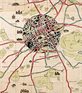 | Details | Pilcher, R. Stuart | 1926 |
| Pictorial map of Edinburgh roads and tramways Scotland |
|
Pilcher, R. Stuart |
|
| 1926 |
| LOC: |
| $275.00 | Pilcher--R--Stuart | Pictorial-map-of-Edinburgh-roads-and-tramways-Scotland | A scarce and graphically interesting pictorial map of Edinburgh and Leith, Scotland, the "Edinburgh Corporation Tramways & Motors" map published 1926 with tramway routes in red and motor bus routes shown in blue. R. Stuart Pilcher, Tramways Manager. Printed by Robert Mitchell and Sons Lithographers, Edinburgh. Verso with cover of Edinburgh skyline and numerous advertisements.
<br><br>
A graphically commanding map of Edinburgh, the core of the city displayed in a circle with black overtones and colorful motorways radiating outwards past Edinburgh's green spaces- cemeteries, parks, public gardens, and golf courses which include:
<div class="indenttextblocksingle">
<ul style="list-style-type: circle;">
<li>Craigentinny Golf Course</li>
<li>Leith Links</li>
<li>Craigmiller Park Golf Course</li>
<li>Bruntsfield Golf Course</li>
<li>Murrayfield Golf Course</li>
<li>Prestonfield Golf Course</li>
<li>Liberton Golf Course</li>
</ul>
</div>
This pictorial map of Edinburg contains numerous inset sketches of important local buildings including:
<div class="indenttextblocksingle">
<ul style="list-style-type: circle;">
<li>City Poorhouse</li>
<li>Redford Barracks</li>
<li>Merchiston Castle </li>
<li>Dan Steworth College</li>
<li>Royal Observatory</li>
<li>Fettes College</li>
<li>Leith Public Health Hospital</li>
<li>Holyrood Castle</li>
</ul>
</div> |
| 6614 |  | Details | San Francisco Harbor Commission Board | 1940 |
| Detailed Map of San Francisco Waterfront 1940 |
|
San Francisco Harbor Commission Board |
|
| 1940 |
| LOC:1403 |
| $650.00 | San-Francisco-Harbor-Commission-Board | Detailed-Map-of-San-Francisco-Waterfront-1940 | A 55 inch long detailed planning map of the Harbor of San Francisco, California dated 1940. Produced by the Board of State Harbor Commissioners for San Francisco Harbor, Frank White, Chief Engineer. Rare.
<div><img src="/ZoomifyImages/SC_6614/SC_6614_title_detail.jpg" alt="Close-up detail from the title of the Map of the Waterfront of San Francisco 1940 by SF Harbor Commissioners" width="300" align="center" style="margin: 20px 0px 20px 20px"/>
</div>
Documents harbor development in 1940 in minute detail. Coverage sweeps along San Francisco Bay from the South Basin westward and then northward past the Aquatic Park and Fort Mason. Delineates the extent of both the pier head line and the waterfront line. Details each wharf and shows measurements of every space along the waterfront with pier lengths and pier slip widths as well as the very extensive railroad yards and rail lines connected to each dock. Most of these railroad tracks do not exist today.<div><img src="/ZoomifyImages/SC_6614/SC_6614_wharf_detail.jpg" alt="Close-up detail of the waterfront piers near Fisherman's Wharf in San Francisco, California in 1940." width="300" align="center" style="margin: 20px 0px 20px 20px"/>
</div>
Photo-lithograph on a 55" long rolled sheet of thin translucent paper. |
| 6519 |  | Details | Fuller and Whitney | 1885 |
| Charles River Basin and Harvard Bridge Economic Studies |
|
Fuller and Whitney |
|
| 1885 |
| LOC:300 |
| $1,900.00 | Fuller-and-Whitney | Charles-River-Basin-and-Harvard-Bridge-Economic-Studies | Manuscript surveyors-trace economic option studies for road approaches and the proposed West Chester Park Bridge (now, Harvard Bridge, MIT Bridge, or Massachusetts Avenue Bridge). Eight surveyors' trace documents to support civil engineering and economic options for the placement of the Harvard Bridge, spanning the Charles River between Boston and Cambridge, Massachusetts. General plans for the new bridge were approved in July 1887; the bridge opened in September 1891.
<br><br>
The lot consists of eight MS pen and ink traces (for blueprint production) consisting of two base maps of Boston and Cambridge as well as six MS trace sheets with street and bridge options. The two base maps show the Charles River Basin with the existing West Boston Bridge (Longfellow Bridge) and road network. One map has much greater detail on street names and improved larger lettering.
<br><br>
Six map overlays:<br>
<div class="indenttextblocksingle">
<ul style="list-style-type: circle;">
<li>No 1. Shows the proposed new route as well as text and tabular information for the gain or loss of time over the proposed new route.</li>
<li>No. 2 Shaded area shows lands of the Charles River Embankment Company (proposed Esplanade),
proposed approaches to the Charles River Esplanade and proposed West Chester Park Bridge (aka Harvard Bridge)</li>
<li>No. 3 Approaches for the proposed West Chester Park Bridge (east of the final location)</li>
<li>No. 4 Second option. Bridge located at West Chester (aka Massachusetts Avenue) but terminated slightly more to the east.</li>
<li>No. 5 Third option. Bridge at West Chester, and a proposed wide avenue extending to the end of Commonwealth in Cambridge.</li>
<li>No. 6 Fourth option. No Esplanade </li>
</ul>
</div>
Scale 1650 feet to one inch. |
| 6492 |  | Details | Dubuque City Planning Commision | 1951 |
| Master Plan for the City of Dubuque Iowa |
|
Dubuque City Planning Commision |
|
| 1951 |
| LOC:400 |
| $400.00 | Dubuque-City-Planning-Commision | Master-Plan-for-the-City-of-Dubuque-Iowa | Very large, scarce 1951 master plan map of the City of Dubuque, Iowa by the Dubuque City Planning and Zoning Commission, J.M. Wolfe, Chairman. Justin R. Hartzog, City Planner. A fine record of the city and its ambitions in the mid 20th-century.
<br><br>
Two matching legends at bottom right and left show symbols and coloration used for mapped features under existing conditions and for the Commission's planning proposals respectively. These details include streets, railroads, intersections, city boundaries, parks, playgrounds, schools and other land uses. North oriented to top. |
| 6476 |  | Details | Rosen, Ludwig | 1890 |
| Engineers manuscript contour drainage plan of the Gärdet in Stockholm Sweden |
|
Rosen, Ludwig |
|
| 1890 |
| LOC:1402 |
| $900.00 | Rosen--Ludwig | Engineers-manuscript-contour-drainage-plan-of-the-Gärdet-in-Stockholm-Sweden | Early and rare engineer's pen and ink manuscript contour drainage plan of Stockholm's Ladugårdsgärdet [1] by States Engineer Ludwig Rosen in 1890. A hand-drawn and hand colored detailed plan on supple surveyors tracing cloth covering land that was at the time largely undeveloped. Today the outer portions of the Gärdet are well developed leaving a central open space that is part of Stockholm’s National City Park.
<br><br>
An important manuscript engineering plan related to urban growth, development, and the environmental preservation of Stockholm, Sweden.
<br><br>
<div id="0" align="center">
<a title="Täckdikningsplan for Ladugårdsgärde vid Stockholm"></a>
<img id="3" src="/ZoomifyImages/SC_6476/SCV_6476_Title.jpg" alt="Täckdikningsplan for Ladugårdsgärde vid Stockholm" width="300"/> <br><small>Title to Rosen's plan of the Ladugårdsgärde (1890)</small>
</div><br>
Plan shows land contour and numerous profile cross-section inset drawings. From a translation of the title "Täckdikningsplan" we can derive that the purpose of the plan was for the development of "cover ditches" or sub-surface drainage systems. North oriented to upper left. Detailed explanatory legend fills the left side of the plan.
<br><br>
[1] Ladugårdsgärdet or Gärdet is a suburb in Stockholm County east and northeast of Östermalm with a current population of roughly 21,500 residents. Until the mid 1800’s, the eastern areas of Stockholm were known as Ladugårdslandet, or “The Barn Land.” Throughout the 1900’s, large areas of Gärdet were developed. |
| 6459 |  | Details | Heck, Georg | 1851 |
| 19th-century engraving sailing ship and rigging |
|
Heck, Georg |
|
| 1851 |
| LOC:78 |
| $140.00 | Heck--Georg | 19th-century-engraving-sailing-ship-and-rigging | Steel-plate line engraving depicting a triple-decked ship-of-the-line and some of the rigging and equipment with special emphasis on blocks, tackle, and armament. From Georg Heck's "Iconographic Encyclopedia" published by Rudolph Garrigue in New York in 1851. Cool! |
| 6460 | 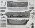 | Details | Heck, Georg | 1849 |
| Antique plans for a three-decked warship ship-of-the-line. |
|
Heck, Georg |
|
| 1849 |
| LOC:78 |
| $140.00 | Heck--Georg | Antique-plans-for-a-three-decked-warship-ship-of-the-line- | Original, antique maritime architectural views of a large three-deck ship-of-the-line. This antique print is full of nautical renderings including a plan of the hull contour; an elevation view showing side framing; a cutaway showing bottom-deck framing plan; a stowage plan view; and numerous smaller details related to naval architecture.
<br><br>Steel-plate engraving. |
| 6436 |  | Details | Monterey California Planning Commission | 1939 |
| 1939 Master Plan with 4 maps City of Monterey California |
|
Monterey California Planning Commission |
|
| 1939 |
| LOC:300 |
| $2,400.00 | Monterey-California-Planning-Commission | 1939-Master-Plan-with-4-maps-City-of-Monterey-California | A landmark in planning for the city of Monterey, California, an early master plan to conserve local historic buildings and landscape features. A significant feature of those conservation efforts was Emerson Knight's establishment of a Ring Route (Map D.) that “links together most of the historic houses and makes broad suggestions for street tree and vacant lot planting." [1]
<br><br>
Rare <b>Master Plan for the City of Monterey, California</b> published May 24, 1939 by the Monterey California Planning Commission. 31 pages and acknowledgements, five maps, (4 detached), more. 8 1/2" x 11". Leather-like embossed card cover, string binding.
<br><br>
Contents include text, 15 photographic images (high quality; one color), small format master plan for the City of Monterey regional sketch map. 8" x 5".
<br><br>
Back section with sleeve containing four separate detached folding maps by Emerson Knight, City Planning Advisor, in top unused condition on fine thin paper. Maps printed by Modern Printing Company, Monterey, CA:
<div class="indenttextblocksingle">
<ul style="list-style-type: circle;"></li>
<li>Map A. Conservation including protection of bay and beach frontage with proposed promenade. Emerson Knight. March 1939. 21" x 13". </li>
<li>Map B. Parks parkways and recreation showing publicly owned lands, all lands to be publicly acquired for parks, parkways, public buildings & streets also proposed promenade, bath house, and pedestrian ways. Emerson Knight. March 1939. 8" x 21". </li>
<li>Map C. Streets and highways existing traffic volumes proposed increase in traffic facilities. Emerson Knight. March 1939. 21" x 13". </li>
<li>Map D. Preservation of historic values including historic buildings and sites also showing historic ring route and proposed planting along course. Emerson Knight. March 1939. 21" x 13". </li>
</ul>
</div> |
| 6429 | 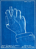 | Details | Holmes, Bradford Butterick | 1911 |
| Four cyanotype sketches for a concealed five shot revolver |
|
Holmes, Bradford Butterick |
|
| 1911 |
| LOC:300 |
| $380.00 | Holmes--Bradford-Butterick | Four-cyanotype-sketches-for-a-concealed-five-shot-revolver | Set of four original antique cyanotype or blueprint inventor's sketches for a concealable revolver. The revolver was designed by Bradford Butterick Holmes in 1911. In December, 1912 Holmes was granted US patent #1,047,054 on the revolver. It was Bradford Holmes' first patent, but not his last.
<br><br>
<div id="1" align="center">
<a title="Holmes' Revolver."></a>
<img id="1" src="/ZoomifyImages/SC_6429/SC_6429_400x300.jpg" alt="" width="250"/> <br><small>Fig. 1. Holmes concealed revolver</small>
</div><br>
The first sheet of four (Fig. 1.) shows an actual size depiction of the revolver concealed within the user's fist, only the short barrel extending beyond the fingers of a hand stretched from a cuff-linked shirt. Sheets 2, 3, and 4 are double size renderings of the revolver's mechanical details. The sketches are dated October 11, 1911 and witnessed by Ruth Vickery Holmes (Bradford's wife) and Hilma Christenson.
<br><br>
In 1903 Bradford Butterick Holmes is recorded as a first year student at the Massachusetts Institute of Technology with his home town listed as Mare Island, California. Apparently Bradford Holmes wed Ruth in May 1909 and together they had two children, Elizabeth and Robert.
<br><br>
Bradford Holmes was a prolific inventor. Between 1912 and 1952 Holmes was granted over 70 patents, some for Bendix Aviation, his presumed employer. In addition to the revolver Holmes' inventions include:
<div class="indenttextblocksingle">
<ul style="list-style-type: circle;"></li>
<li>Automatic steering device for dirigible craft (US1640896A) </li>
<li>Pressure breathing regulator (US2544991A) </li>
<li>Demand valve control mechanism (US2608971A)</li>
<li>Electric timing system (US2080273A) </li>
<li>Windshield wiper and fluid motor therefor (US1731048A)</li>
</ul>
</div>
Ruth Holmes is named as a co-inventor on eight of Bradford's patents, largely from the 1930's, related to a dirigible steering mechanism. |
| 6412 |  | Details | Uren, Edward Clement | 1940 |
| Mining claim map Grover Murphy Nevada City California |
|
Uren, Edward Clement |
|
| 1940 |
| LOC:10 |
| $250.00 | Uren--Edward-Clement | Mining-claim-map-Grover-Murphy-Nevada-City-California | Plat map of the Grover Murphy Claims Nevada City, California from 1940 by Edward Clement Uren M.E. (1873 - 1861). The gold claim was near Indian Flat Road about 1.8 km WNW of Nevada City.
<br><br>
At upper left the circular professional stamp of Edw. C. Uren, Registered Civil Engineer.
<br><br>
Little is known about the life of E. C. Uren. In 1912 Uren quit his job as superintendent of the Champion mine in Nevada City, CA to start a practice as a civil and mining engineer. |
| 6428 |  | Details | Anonymous | 1949 |
| Cartoon map of UC Berkeley engineering underground radiation nuclear laboratory |
|
Anonymous |
|
| 1949 |
| LOC:300 |
| $850.00 | Anonymous | Cartoon-map-of-UC-Berkeley-engineering-underground-radiation-nuclear-laboratory | Original centerspread 1949 cartoon pictorial map, "Underground Campus", the campus of the University of California Berkeley, specifically the engineering underground tunnels and facilities including the Radiation Lab. Scientists at the UC Radiation Laboratory, now the Lawrence Berkeley National Laboratory, discovered berkelium (atomic number 97) in 1949 using a 60-inch cyclotron.
<br></br>
<div id="3" align="center">
<a title="California Engineer smoking weed?"></a>
<img id="3" src="/ZoomifyImages/SC_6428/SC_6428_SmokingWhat.jpg" alt="Early depiction of a Berkeley Engineer with roach clip." width="240"/>
</div><br>
The California Engineer began in 1903 as the California Journal of Technology. It was the first college magazine in the west to specialize in the area of science and technology. In January, 1923, after a hiatus of ten years, the magazine was revived and renamed "California Engineer" by the Student Engineers Council (1).
<br></br>
The comical map is centered around Sather Tower with a cutaway view of the subterranean network below the halls at the University of California at Berkeley. Includes Sather tunnel, Leconte Hall, Gilman Hall, Wheeler Auditorium, The Radiation Laboratory housed the research at UC Berkeley during WWII under the Manhattan Project. Note the IBM punch card machine gag at bottom left.
<br></br>
The comical map is from the January 1949 issue of <b>California Engineer</b>, the annual "Mad Issue". 36 pages. Price when issued 25 cents. Published at the University of California, Berkeley, California by the Associated Students of the University of California. |
| 6450 |  | Details | Gluck, Jay | 1948 |
| Cartoon cutaway view of UC Berkeley dormitory life |
|
Gluck, Jay |
|
| 1948 |
| LOC:1 |
| $1,000.00 | Gluck--Jay | Cartoon-cutaway-view-of-UC-Berkeley-dormitory-life | With the premiere of the IMAX biopic "Oppenheimer" (1) less than one week away (7/18/2023) we offer "Oppy's Flop House", a rare and culturally insightful 1948 cartoon cutaway elevation view of a dormitory at the University of California at Berkeley, where Oppenheimer taught physics from 1929 to 1943.
<br><br>
<div id="0" align="center">
<a title=""></a>
<img id="6450" src="/ZoomifyImages/SC_6450/SC_6450_detail_1.jpg" alt=" Rare, culturally insightful 1948 cartoon cutaway elevation view of a dormitory at the University of California at Berkeley, where Oppenheimer taught physics from 1929 to 1943." width="300"/> <br><br> <font size="-2">Oppy's Flop House- Oppenheimer Caricature Detail</font>
</div><br>
Oppy's Flop House was published in the 1948 annual "Mad Engineer" issue of "California Engineer", a student publication of the University of California at Berkeley.
<br><br>
The title "Oppy's Flop House" refers to Robert Oppenheimer [2], one of the key researchers on the Atomic Bomb that had been dropped on Japan less than three years earlier. Cartoons and sight gags include a slide rule used as a fishing device and as a guitar, chem lab equipment used to brew coffee, students using radar to peer into the room of a bathing coed, a robot, a device based on compressed air to raise the skirts of coeds, and many scenes that include engineering book gags.
<br><br>
[1] https://www.oppenheimermovie.com/<br>
[2] Physicist <strong>Robert Oppenheimer</strong> (1904-1967) was Project Director for the <strong>Manhattan Project</strong>. Oppenheimer taught at UC Berkeley from 1929 - 1943. "With the rise of the Nazi party in Germany, the University quickly became a hub for atomic weapons development. By the outbreak of World War II, Oppenheimer, his students, and several notable physicists probed atomic theory on the top floor of Le Conte Hall." |
| 6353 | 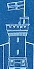 | Details | Coyle, J. E. F. | 1895 |
| Blueprint Sydney Northbridge Suspension Long Gully Bridge |
|
Coyle, J. E. F. |
|
| 1895 |
| LOC:300 |
| $1,500.00 | Coyle--J--E--F- | Blueprint-Sydney-Northbridge-Suspension-Long-Gully-Bridge | Beautiful, original late 19th century cyanotype (blueprint) profile view of the "North Sydney Bridge" NSW, then a suspension bridge, (also known as Northbridge or Long Gully Bridge). Original 48" rolled old blueprint paper with slight signs of wear consistent with date of late 19th century but fresh and bright from a protected environment. The rigid symmetry of the suspension bridge contrasts with the sketch-like character of the title and gully profile. Scale 20' = 1".
<br></br>
The Suspension Bridge in Northbridge, NSW was built as a steel suspension bridge with sandstone turreted towers by a private syndicate to promote residential development. The bridge opened to traffic in in January, 1892. With a suspension span of about 500 feet, it was considered one of the engineering wonders of Sydney and became a great tourist attraction. In 1939 the bridge was rebuilt as a reinforced concrete two rib arch bridge, with the original towers intact. (1)
<br></br>
Manuscript address on the verso "F. L. Keir Esq. Chief Engineer's. Railway Department. Brisbane. Queensland." Keir was an engineer with the railways department (2).<br /><br />
Sources:<br /> |
| 5297 |  | Details | Armstrong, Edward Robert | 1927 |
| Armstrong Seadrome map Floating airstrips Atlantic repeater station |
|
Armstrong, Edward Robert |
|
| 1927 |
| LOC:1405 |
| $750.00 | Armstrong--Edward-Robert | Armstrong-Seadrome-map-Floating-airstrips-Atlantic-repeater-station | Very rare cyanotype (blueprint) engineering diagrams from 1927 and a Seadrome route map related to Edward Robert Armstrong's Seadrome System, a proposed system of floating airports. Armstrong's Seadrome was the first major concept for a stable floating structure at sea. Its design influenced the later development of the semi-submersible drilling rig. [1]. Armstrong's Seadrome Map (center of sheet) shows locations of repeater structures and airports planned to be anchored in the Atlantic Ocean. Only available original map of the Seadrome concept signed by Armstrong.
<br></br>
In the late 1920's aircraft did not have the capacity to carry passengers non-stop across the Atlantic. Armstrong's Seadrome System was designed to anchor huge landing fields in the Atlantic Ocean at 375 mile intervals, enabling short-range aircraft to hop across the Atlantic.
<br></br>
Signed at bottom right corner "E.R. Armstrong 5/16/27."
<br></br>
This diagram shows Armstrong's Seadrome semi-submersible concept, modified and adapted for use as a repeater station for trans-Atlantic cable traffic. The repeater stations were conceived in order to increase the bandwidth of cables across the Atlantic, which in the late 1920's was limited to a single telephone conversation. Through the use of Armstrong's semi-submersible repeater stations and two cables Bell Telephone engineers calculated that eight circuits across the Atlantic Ocean might be achievable. In the end, the floating repeater station idea was scrapped as it was believed impractical. [2]
<br></br>
[1] Pease, F. T. The Armstrong Seadrome: World's First Semi-Submersible Design ??? The Society of Naval Architects and Marine Engineers. 13th Offshore Symposium, 24 February, Houston, Texas. January 21, 2004.
[2] Jacobs, O.B. Bell Laboratories Record. Vol XXXV. Number 6. June 1957. p. 207.
[3] https://sites.google.com/site/richardarthurnorton/edwardr.armstrong |
| 5265 |  | Details | Whitfield Colliery | 1928 |
| Three MS plans mining accidents Whitfield Colliery, Staffordshire, England |
|
Whitfield Colliery |
|
| 1928 |
| LOC:7 |
| $265.00 | Whitfield-Colliery | Three-MS-plans-mining-accidents-Whitfield-Colliery--Staffordshire--England | Lot containing three manuscript plans related to mining accidents at the Chatterley Whitfield colliery (coal mine) in Stoke-on-Trent, Staffordshire, England. The three accidents took place over a period of eight years, attesting to the danger of coal mining.
<div class="indenttextblocksingle">
<ul style="list-style-type: circle;">
<li>Plan shewing scene of accident to Charles Stubbs on Newtons No. 3 north conveyor face institute pit 29th Oct. 1935. [MS plan on paper at a scale of 1/4" = 1 foot]</li>
<li>Plan showing scene of accident to Joseph Howell on No. 5 Bowling Alley Level, Holly Lane dip in the middle pit. 8/1/37 [MS plan of tracing cloth. Scale 1/4" = one foot]</li>
<li>Plan shewing scene of accident to Richard Harper in the No. 3 south ten feet, hard mine dip, middle pit on 27-3-29. [MS plan of tracing cloth. Scale 1/4" = one foot] </li>
</ul>
</div>
The Chatterley Whitfield colliery was the largest mine working the North Staffordshire coalfield and was the first colliery in the UK to produce 1,000,000 tons of saleable coal in a year (1938). In 2019, the colliery was named on the Victorian Society's list of the top ten most endangered buildings in England and Wales. |
| 5242 |  | Details | Zulch, Herman C. | 1934 |
| Maps of the Mossback Gold Mine near Oatman Arizona |
|
Zulch, Herman C. |
|
| 1934 |
| LOC:62 |
| $550.00 | Zulch--Herman-C- | Maps-of-the-Mossback-Gold-Mine-near-Oatman-Arizona | Scarce lot of six hand-colored blue-line mine maps of the Mossback Mine near the town of Oatman in Mohave County, Arizona. Five of the six maps show a distinctive tunnel, or level, of the mine (levels 100-400 (12" x 17") and level 700 (17" x 46")). The sixth and most interesting map is the "Cross Section Through Mossback Shaft" (18" x 26") which shows the Ritter Vein and the Mossback Vein, reported to be a rich source of gold ore. From a geological perspective the map projects the potential position of the Mossback Vein as it was shifted by the Mossback Fault.
<br></br>
According to the Arthur Lakes Library at the Colorado School of Mines the tunnel maps and cross-section map are scarce:
<div class="indenttextblocksingle">
"Most mining maps show a mining district or region. . . Most of mine maps in our collection show only the location of the claims, not the tunnels. Very few maps show cross-sections of a mine." [1]
</div></br>
The Mossback Mine, at an altitude of 2,400 feet, was first discovered in 1863 by Garry Mining Company. Past operations took place as late as 1933 to 1935, but the mine is now closed. The Mossback vein extended nearly half a mile in length and was 23 feet in width at the surface, widening to 40 feet at the bottom. The ore contained up to $2,000 in gold per ton (100 ounces per ton). [2]
<br></br>
Traced by mining engineer Herman Zulch at Oatman, Arizona. Herman Charles Zulch graduated from the Colorado School of Mines in May 1908.
<br></br>
Sources include:
</br>
[1] https://libguides.mines.edu/maps/mining</br>
[2] https://thediggings.com/mines/6530 |
| 5223 |  | Details | National Fire Service Benevolent Fund | 1944 |
| Bird's-eye View of the V1 Bomb an Early Cruise Missile |
|
National Fire Service Benevolent Fund |
|
| 1944 |
| LOC:13 |
| $110.00 | National-Fire-Service-Benevolent-Fund | Bird-s-eye-View-of-the-V1-Bomb-an-Early-Cruise-Missile | Single-page folding booklet with a schematic diagram of the German V-1 bomb flying above a bird's eye view of the British countryside. The V-1 was a German weapon, an early and crude cruise missile, designed to strike terror into the British population. During World War II Germany used the V-1 in the thousands against south-east England from launch sites along the French and Dutch coasts.
<br></br>
Reproduced from the London Illustrated News with proceeds devoted to the National Fire Service Benevolent Fund.
<br></br>
With text, cutaway drawings, and inset schematic diagrams explaining of the German impulse engine (an early jet engine) and the mechanism used to control the missile's flight path. Verso with text and title page.
<br></br>
Price when issued: sixpence. Drawn by G.H. Tavis. 1944. Printed by Temple Fortune Press. Printers. London. |
| 5219 |  | Details | International Navigation Congress | 1908 |
| Report of the 11th meeting of the International Navigation Congress |
|
International Navigation Congress |
|
| 1908 |
| LOC:2001 |
| $100.00 | International-Navigation-Congress | Report-of-the-11th-meeting-of-the-International-Navigation-Congress | Scarce booklets (24) of reports for the 11th meeting of the International Navigation Congress or Association Internationale Permanente de Congres de Navigation, held in St. Petersburg, Russia during 1908. Some reports with folding plates. Authors of these reports represent a diverse set of countries including but not limited to: Germany, England, Belgium, Russia, France, Italy, and the United States.
<br></br>
Contents include booklets in French or English text (some with engineering or hydrographic plates). The topics are related to five broad areas of interest:
<div class="indenttextblocksingle">
<ul style="list-style-type: circle;">
<li>Fishing ports and harbors for coastal maritime trade.</li>
<li>Economic and engineering studies for Inland maritime ports.</li>
<li>Port construction on sandy beaches.</li>
<li>General conditions for secure maritime navigation.</li>
<li>Hydrographic exploration of the seas.</li>
</ul>
</div>
Hard cover binder secured by string closures with 24 reports, each staple bound with paper covers. Some booklets bear the oval stamp of the Liverpool Engineering Society. |
| 5220 |  | Details | Women's Army Corps | 1944 |
| Stand-up Poster for WAC Topographic Draftsman |
|
Women's Army Corps |
|
| 1944 |
| LOC:13 |
| $225.00 | Women-s-Army-Corps | Stand-up-Poster-for-WAC-Topographic-Draftsman | Among the key events impacting the women's movement was World War II. With men away at war, tens of thousands of women entered the workforce to meet the demands of the war for labor. Among the most well-known was "Rosie the Riveter". Here we might have an advertisement to fill the job of "Carrol the Cartographer".
<br></br>
A table-top, stand-up World War II recruitment poster printed on heavy card stock for the Women's Army Corps (WAC) depicting a woman drawing on a map with pencil and protractor. The job specialty promoted is Topographic Draftsman, part of the Army Ground Forces.
<br></br>
With a black ink over-stamp for the U. S. Army Recruiting Station, Room 217 New Post Office Building, Utica N. Y. Illustration is signed but unreadable. |
| 4900 |  | Details | Anonymous | 1925 |
| Cyanotype Heath Robinson contraption goat-powered torpedo |
|
Anonymous |
|
| 1925 |
| LOC:62 |
| $650.00 | Anonymous | Cyanotype-Heath-Robinson-contraption-goat-powered-torpedo | You will likely never see another one of these. From the Roaring Twenties- a cyanotype (blueprint) Heath Robinson style contraption- a goat-powered torpedo. The satirical proposed device shows advanced knowledge of torpedo design and function. (e.g. bulkheads).
<br></br>
Early Newport, RI colonists used Goat Island as a goat pasture. In 1925 the U.S. Navy operated a torpedo manufacturing, development and testing station on Goat Island.
<br>
<div class="indenttextblock">The anonymous author explained:
"The torpedo is made in three sections, the head, the midship section and after body. The drawing shows the mechanism at rest. The operation is as follows: When the torpedo is fired from the tube the trigger comes in contact with a lug which causes the trigger arm to displace the cobble with falls on the Bermuda onion and crushes it. The onion gases thus released cause the goat to weep copiously. The tears are caught in the funnel on the top of the sal-ammoniac pin. These tears dissolve the sal-ammoniac pin. Thereby releasing the spring rod and prodder. This unit moves smartly forward, engaging the port quarter of the goat, thereupon the goat steps out and operates the asbestos tread mill, which is connected to the gear train that operates the propellers. A gaff and boom rig operated by the gear train, operates a spur gear which revolves rapidly on the goats back guaranteeing the continuance of the motion started by the goat prodder, the derby on the goat prevents him from catching cold while the torpedo is in the tube. It is obvious that if he should catch cold he would be rendered useless as an onion weeper. The hat also serves as a cut-off in the following manner; after a certain speed has been attained the goat has a desire to take off his hat and be comfortable, so he therefore tosses it to the rear where it falls in the gear train and jams it. Any torpedo expert will explain this to you if the above elucidation is not perfectly clear.
</div> |
| 4862 |  | Details | Foreman, D. H. | 1916 |
| Antique Plans Hidden Treasure Mine Lake City, Colorado |
|
Foreman, D. H. |
|
| 1916 |
| LOC:0 |
| $3,250.00 | Foreman--D--H- | Antique-Plans-Hidden-Treasure-Mine-Lake-City--Colorado | The most interesting set of gold mining plans I have seen!
<br><br>
A very absorbing pair of fine antique presentation plans for the Hidden Treasure Mine at Lake City, in Hinsdale County, Colorado between Crystal Creek and Ute Creek. The Hidden Treasure Mine (1897-1922) was a gold, silver, lead, and copper mine located at an elevation of 10,200 feet.
<br><br>
Both plans are hand-colored blue-line artifacts on architectural vellum.
<b>Plan 1 includes:</b>
<div class="indenttextblocksingle">
<ul style="list-style-type: circle;">
<li>Fig 1. Plan Map of the Hidden Treasure Property</li>
<li>Fig 2. Longitudinal Section of Slope of Vein Looking West.</li>
<li>Fig 3. Plan of Underground Workings.</li>
</ul>
</div>
<b>Plan 2 includes:</b>
<div class="indenttextblocksingle">
<ul style="list-style-type: circle;">
<li>Fig 4. Longitudinal Section Underground Workings. Looking West.</li>
<li>Fig 5. Cross-section Through "X-Y" (Plate 1) Looking S.W.</li>
<li>Sampling data and ore valuation table.</li>
</ul>
</div>
Dated within to 12/20/16. Drawn by D.H. Foreman, Denver, Colorado.
<br></br>
The old Hidden Treasure Dam on Henson Creek, built in the 1890's, made the news in late May, 2019. It was announced that the dam was to be demolished because of the concern for flash floods associated with the potential for sudden heavy snowmelt. (Source: https://www.cpr.org/news/story/historic-hidden-treasure-dam-is-coming-down-to-ease-the-flood-threat-to-lake-city)
<br></br>
On Fig 1. Plan Map of the Hidden Treasure Property two tunnels are shown leading to the Lower Terminal Mill. More than 100 years old, the Hard Tack Mine tunnel was built as an underground transport tunnel for the Hidden Treasure Mining Company's ore production one quarter mile up the mountain (shown here as "proposed"). The Hardtack Mine now (2024) houses a museum designed to preserve area mining history and offers tours June to September. |
| 4801 |  | Details | Rathbun, Frank A. | 1890 |
| Early Cyanotype Advertisement for Rathbun's Wagon Jack and Wrenches |
|
Rathbun, Frank A. |
|
| 1890 |
| LOC:10 |
| $560.00 | Rathbun--Frank-A- | Early-Cyanotype-Advertisement-for-Rathbun-s-Wagon-Jack-and-Wrenches | A rare 19th-century <b>cyanotype print folk-art advertisement</b> ca. 1890 for F.A. Rathbun's wagon jack and wrenches. No other copy of any advertisement for Rathbun or his equipment is found online. The blueprint (cyanotype) photographic process, invented in 1842, was not adopted widely as a business document reproduction technology until after 1880.
<br></br>
With two cartoon-like drawings illustrating the "Worst Way" and the "Best Way" to change a wheel on a buggy or wagon (no mention of automobiles). The best way according to the author is Rathbun's Wagon Jack and Wrenches. Compliments of F.A. Rathbun Beloit, Wisconsin.
<br></br>
With an additional 3" x 7" cyanotype print of a large wrench labeled "F.A. Rathbun Beloit Wis."
<br></br>
The ad copy reads:
<div class="indenttextblock">
"Compliments of F.A. RATHBUN. BELOIT WIS. Manufactuer [sic] of his celebrated Wagon Jacks & Wrenches. By the use of which any one can grease thier [sic] wagon or buggy in less then one half the time required by the use of any other jack and wrench in the market without soiling hands or clothes. The pecular [sic] construction of the jack and manner in which it is used, recommmends its-self to all who know the trouble usually experienced with all jacks that have to be used under the buggy. This is the only jack that can be used at the end of the axle so that the wheel can be slid out on it for support. The 'wrench' also recommends itself to all who would avoid geting [sic] themselves greasy and dirty or straws and dirt on the nut to be scraped off or remain on to wear out the spindle. It is always ready. Never slips, and is quickly and easily operated. All who have used them recommed [sic] them to others. Liberal discount, to the trade and agents."
</div>
In April 1887 Frank A. Rathbun a machinist of Beloit Wis. assigned a patent he held on a wheeled scraper to F.W. Kimball of Milwaukee, Wis. However there is no mention of a patent on Rathbun's wagon jack. |
| 2540 |  | Details | Fuller and Whitney | 1885 |
| Antique blueprint engineer's plan of Boston's Charlesgate East area |
|
Fuller and Whitney |
|
| 1885 |
| LOC:86 |
| $375.00 | Fuller-and-Whitney | Antique-blueprint-engineer-s-plan-of-Boston-s-Charlesgate-East-area | Original rare cadastral blueprint plan from September 22, 1885 providing detail for a portion of Boston's Back Bay on Beacon Street, Marlborough Street, and Commonwealth Avenue west of West Chester Park (Massachusetts Avenue) and east of Ipswich Street (Charlesgate East). At center left the reader will find the Beacon Entrance to Back Bay Park.
<br></br>
This blueprint, and perhaps other like it, were the end product created from <a href="https://www.rarecharts.com/ShowDetail/Creator/Fuller-and-Whitney/Title/Antique-manuscript-engineers-traced-plan-of-Boston-s-Charlesgate-East-area/2543" target="_blank">a manuscript trace document</a> by William H. Whitney.
</div>
Verso is blank.
<br></br>
During the period 1872 to 1888 Fuller & Whitney Civil Engineers, was conducted as a partnership between J. Franklin Fuller and William H. Whitney with offices at 39 Court Street, Boston, Mass. Whitney assumed sole control of the firm in 1888 and changed the name to William H. Whitney.
<br></br>
In his autobiography Whitney refers to his work with the latest cutting-edge reprographic technology- blueprinting: <div class="indenttextblock">“In September 1881 I received a bronze medal at the Massachusetts Charitable Mechanic Association Exhibit for sun or blue prints. I developed a process from the French and used it in illustrating the growth of Back Bay lands. I issued to subscribers monthly schedules and maps showing the changes of ownership, increase in value, improvement by filling and public works.” (The New England Historical and Genealogical Register. Vol 64, January 1910. Number 253. p. lix).</div> |
| 2541 |  | Details | Fuller and Whitney | 1886 |
| Antique blueprint plan of Boston near Huntington and Massachusetts Avenues |
|
Fuller and Whitney |
|
| 1886 |
| LOC: |
| $300.00 | Fuller-and-Whitney | Antique-blueprint-plan-of-Boston-near-Huntington-and-Massachusetts-Avenues | Original cadastral blueprint plan from Jan. 1, 1886 of a portion of the Boston' Back Bay east of Massachusetts Avenue. The area includes the current location of the Boston Philharmonic Orchestra at 236 Huntington Ave. In the upper portion of the plan an artifact of the blueprint process reveals where a piece of lint or vegetation landed between the surveyor's trace and blueprint paper during exposure of the paper to sunlight.
<br></br>
The area for this blueprint in Boston, Massachusetts is bounded on three sides by Falmouth Street, West Chester Park (now Massachusetts Avenue) and St. Botolph Street. Verso is blank. Sheet is labeled "M". |
| 2543 | 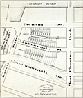 | Details | Fuller and Whitney | 1885 |
| Antique manuscript engineers traced plan of Boston's Charlesgate East area |
|
Fuller and Whitney |
|
| 1885 |
| LOC:86 |
| $500.00 | Fuller-and-Whitney | Antique-manuscript-engineers-traced-plan-of-Boston-s-Charlesgate-East-area | William H. Whitney was a very early adopter of the "blue process" or blueprinting . Both this trace and the <a href="https://www.rarecharts.com/ShowDetail/Creator/Fuller-and-Whitney/Title/Antique-blueprint-engineer-s-plan-of-Boston-s-Charlesgate-East-area/2540" target="_blank">blueprint produced from this trace</a> were created by Whitney just 4 years after the earliest recorded use of blueprints for his Boston-based civil engineering firm.
<br><br>
This rare artifact is the original manuscript cadastral ink trace on tracing cloth from September 22, 1885 providing plan detail for a portion of the Boston Back Bay on Beacon and Marlborough Streets and Commonwealth Avenue west of West Chester Park (Massachusetts Avenue) and east of Ipswich Street (Charlesgate East). This trace would have been used as the reproducible master source to create one or more blueprints, then a new reprographic technology.
<br><br>
With Fuller & Whitney's ink oval over stamp. MS number in pencil at bottom right: "1277".
<br></br>
</div> |
| 621 |  | Details | Arnaves, J. | 1683 |
| Naval Architecture- Pieces of an First Rate French Warship circa 1683 |
|
Arnaves, J. |
|
| 1683 |
| LOC:55 |
| $2,600.00 | Arnaves--J- | Naval-Architecture--Pieces-of-an-First-Rate-French-Warship-circa-1683 | Highly interesting and very rare graphical parts diagram of all the pieces used in the construction of a French first-rate ship-of-the line, including structural members. This is an antique original copperplate engraved print dated within to 1683. Attribution at bottom left is to the creator "J. Arnave fec(it)" but the original inspiration for the work is attributed within an inset to Francois Coullomb: "Faict a Toulon dans lescolle de la construction par Francois Coullomb Fitz avec permission 1683." <br></br>
The original usage of the diagram by Coullomb was as a large wall chart for students at the royal shipyard at Toulon, France. Includes ( in French ) the name, count, and size of each piece. The pieces shown include frames, longitudinals, knees, bitts, grates, masts, capstans, ladders, cannon, anchors, rudder, and numerous decorative trim. <br></br>
This work was probably bound into a copy of Henri Sbonski de Passebon's "Plan de Plusieurs Batiments de Mer avec leurs Proportions" a volume of engravings dedicated to late 17th century nautical architecture. <br></br>
Published from Toulon, France, the home to the regular French naval forces ( Vaisseaux ). |
| 619 | 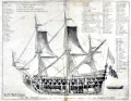 | Details | Henri Sbonski de Passebon | 1690 |
| Antique 17th Century Cutaway View of French Admiral's Flagship |
|
Henri Sbonski de Passebon |
|
| 1690 |
| LOC:55 |
| $750.00 | Henri-Sbonski-de-Passebon | Antique-17th-Century-Cutaway-View-of-French-Admiral-s-Flagship | Antique and scarce 1690 cutaway architectural view of a French Admiral's flagship of 104 cannons. Bernard Quaritch's Catalog No. 229. <sup>1 </sup> attributes the engraving's design to French galley Captain Henri Sbonski de Passebon and the engraving to Claude Randon in de Passebon's "Plans de Plusieurs Batiments de Mer avec leurs Proportions". <br></br>
This highly detailed plate is one of 17 folio-sized antique copperplate engravings in that work which included a similar cutaway of a oared galley. Engraved by Claude Randon, the volume of nautical architecture plates was first published from Marseille where, in the late 17th century the arsenal was home port to the galley service of Louis XIV.<br></br>
<sup>1 </sup> Quaritch, Bernard. "Catalogue of Works on the Fine Arts offered at the net prices affixed, By Bernard Quaritch." London, 1904. http://books.google.com/books?id=i0tFAAAAYAAJ&dq. |
| 448 |  | Details | Benard, Robert | 1770 |
| Fonte des Canons |
|
Benard, Robert |
|
| 1770 |
| LOC:0 |
| $875.00 | Benard--Robert | Fonte-des-Canons | A fine gift for anyone with an interest in engineering, weaponry, or European history. A scarce pair (2) of archivally-matted antique copperplate engravings by Robert Benard depicting large mortars ca. 1738. In the early 18th century a mortar was essentially a squat, wide tube with very thick walls to withstand high pressure.
<br></br>
<img src="/ZoomifyImages/SC_309/SC_309_400x300.jpg" alt="de Passebon: Bomb Ketch. 1690." width="200" align="bottom" style="margin: 5px 10px 5px 0px"> </BR>
<a href="https://www.rarecharts.com/ShowDetail/Creator/Henri-Sbonski-de-Passebon/Title/Galiote-a-bombe/309" target="_blank">The 'Galiote a bombe' </a>(bomb vessel or bomb ketch) pictured inset is an antique engraving in our inventory created ca. 1690 by French galley Captain Henry Sbonski de Passebon (1637-1705). Either one or two mortars were usually placed aboard a bomb vessel which could be one of two types of vessels, either a specially built ketch (ketch: a two-masted, fore-and-aft-rigged sailboat with a mizzenmast smaller than the foremast) or, as is the case here, a converted three-masted vessel where the foremast had been removed, to provide a good deck space forward for the mortars.
<BR> </BR>
As a Captain in France's Corps des Galere, de Passebon was intimately familiar with this type ship and he is reported to have participated during the French bombardment of Genoa in 1684 , aboard the "la Perle" .
</BR>
The cannon are decorated with crown and globe containing three fleur-de-lis, figures representing the French royal coat of arms in the eighteenth century. From Diderot's "Encyclopédie ou Dictionnaire raisonné des sciences, des arts et des métiers, par une Société de Gens de lettres. Total dimensions with mat about 16.5" W x 19.5" H. Mat approx 5" per side. "Benard direxit". |
| 306 | 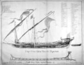 | Details | Henri Sbonski de Passebon | 1690 |
| Coupe d'une galere avec ses proportions |
|
Henri Sbonski de Passebon |
|
| 1690 |
| LOC:50 |
| $1,400.00 | Henri-Sbonski-de-Passebon | Coupe-d-une-galere-avec-ses-proportions | "Coupe d'une galere avec ses proportions" is one of a series of 17 antique folio-sized copperplate engravings created ca. 1690 by <strong>French galley Captain Henry Sbonski de Passebon.</strong> Scarce cutaway print of a standard late <strong>17th century French galley</strong> (galère, Fr.) with a detailed legend of parts (in French). Below the galley is a representation of the keel-form at the shipyard on which the keel was apparently built up. Very scarce.
<BR> </BR>
<a style="color:#9BAFCB" rel="nofollow" href= "/SbonskiPassebonBackground.aspx">View all Sbonski de Passebon engravings</a>
<BR> </BR>
Engraved by Barthelemy Chasse, the collection of nautical architecture plates was first published from Marseille where, in the late 17th century the arsenal was home port to the galley service of Louis XIV. This is the only plate in the volume engraved by Chasse. All other plates were engraved by Claude Randon.
<BR> </BR>
De Passebon was stationed at Marseilles as a Lieutenant in the Corps des Galeres during the period that he produced the drawings from which these plates were engraved.
<BR> </BR>
Attribution at bottom left: "Randon delineauit et sculpsit cura D'ni de Passebon Equitis"
<BR></BR>Royal privilege at bottom right: "Marsiliae cum privilegio Regis"
<BR></BR>Seller's attribution: <strong>"Se vendent a Marseilles chez Laurent Bremond sur le port au Coin de reboul"</strong> (Sold by Laurent Bremond from the port [Marseille] at the corner of Reboul [street].) |
| 6777 | 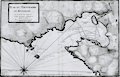 | Details | Ayrouard, Jacques | 1746 |
| Plan du Portvendre en Rousillon |
|
Ayrouard, Jacques |
|
| 1746 |
| LOC:8 |
| $375.00 | Ayrouard--Jacques | Plan-du-Portvendre-en-Rousillon | Fine original hydrographic port and harbor chart for Portvendre (Port-Vendres), France by Jacques Ayrouard (Marseilles ca. 1732- 1746). This antique copperplate engraving shows the town of Port-Vendres as it was in 1733 with the adjacent topography in great detail. Noted features include the Devil's Tower- "Tour de Diable", Fort de la Mauresque or "le Fort et le Fanal", "la Redoutte", the "Cote qui va a Cadequie" and "Cote qui va a Colioure., "le bourg", two other towers- "la masane" and "St. Elme", and the "maison du gouvernment". North is oriented to the bottom of the chart.
<br></br>
Ayrouard makes extensive use of depth soundings and variegated stippling for rough depth contour intervals and has laid down sight bearing lines from the above towers to other fixed objects to help mariners navigate the challenging entrance to Port-Vendres.
<br></br>
<div id="0" align="center">
<a title=""></a>
<img id="6777" src="/ZoomifyImages/SC_6777/SC_6777_detail_1.jpg" alt="Plan du Portvendre en Rousillon. A hydrographic port plan for Port-Vendres, Frances by Jacques Ayrouard. 1746." width="340"/> <br><br> <font size="-2">View of Port-Vendres, Frances by Ayrouard, 1746.</font>
</div><br>
Sourced from Ayrouard's scarce sea atlas: "Recueil de Plusiers Plans des Ports et Rades et de Quelque Cartes Particulieres de la Mer Méditerranée." Beautifully engraved by Louis Corne.
<br></br>
Ayrouard was a pilot of the French royal galley, the Reale, based in Marseille, France. The much larger size (18"x11") and extensively shaded topography in this plan are distinctive characteristics of Ayrouard's nautical port plans. Plate 68. <BR> </BR> |
| 50 | 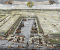 | Details | Kip, Johannes | 1728 |
| Howland Great Dock near Deptford |
|
Kip, Johannes |
|
| 1728 |
| LOC:141 |
| $800.00 | Kip--Johannes | Howland-Great-Dock-near-Deptford | A scarce early 18th century engraved view of the Howland Great Wet Dock (later Greenland Dock) at Rotherhithe, depicting one of the earliest purpose built wet docks in England and a key stage in London's transition from medieval tidal wharfage to enclosed, engineered dock systems. This view has margins > 3 inches. Shown from an elevated birds eye perspective, the composition centers on the rectangular dock basin with its lock entrance to the Thames, where vessels remain afloat at constant water level, a significant technical advance for fitting out, repair, and long term mooring. The surrounding slips, yards, cranes, and ancillary structures are rendered with functional clarity, presenting the dock as modern working infrastructure rather than a picturesque river view.<br><br>
The landscape context is especially revealing. The dock is set amid extensive tree cover and open ground, reflecting the still semi rural character of Rotherhithe in the late 17th and early 18th century. At this date, heavy maritime industry coexisted directly with pasture, orchards, and managed estate land, long before the dense urbanization of the later Georgian docks. The trees are therefore not decorative additions but accurate markers of an early industrial riverside landscape.<br><br>
The wooded setting also had practical importance. Trees stabilized soft riverbank soils and reclaimed ground, and acted as windbreaks for the exposed basin. Their orderly placement reinforces the docks role as a planned improvement, signaling permanence, investment, and control rather than ad hoc industrial growth. Engraved by Johannes Kip, the view combines topographical accuracy with a promotional intent, asserting the technical competence and commercial ambition behind one of London's earliest modern docks.<br><br> |