| | Thumbnail | | Creator | Date | Title / Author / Date / Location | Price | | | Description |
| 757 | 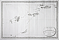 | Details | Beautemps-Beaupre, Charles-Francois | 1793 |
| Carte Generale de la Partie du Grand Archipel d'Asie |
|
Beautemps-Beaupre, Charles-Francois |
|
| 1793 |
| LOC:59 |
| $2,550.00 | Beautemps-Beaupre--Charles-Francois | Carte-Generale-de-la-Partie-du-Grand-Archipel-d-Asie | The Singapore Library web site sums up the significance of this scarce map of Asia: "Map of Indonesia showing tracks of Recherche and Esperance in 1792-1793. This map is part of the great archipelago of Asia, recognized by Rear Admiral Bruny-Dentrecasteaux, in 1792 and 1793" (1). This very scarce copper-plate engraved map is by Charles-François Beautemps-Beaupré (1766-1854). Charts by Beautemps-Beaupre are scarce. Only one other instance of this map is found in the AMPR.
<br></br>
On thick wove paper.
<br></br>
Chart of the waters and islands lying to the north of Australia including portions of the Ceram Sea, Arafura Sea, Banda Sea, and Molucca Sea, Key geographical features include a passage labeled "Dampier Strait", Waigeo ( Waigiou ), Batanta, Ceram, Ambon, Northern New Guinea, and Sulawesi ( Celebes ) and Timor. Much of the coastline of these islands is left blank because as of 1793 they were still uncharted and unexplored.
<br></br>
The map shows the track of two ships, the Recherche and Espérance , as they conducted an expedition (1791 - 1793) led by French Rear-Admiral Antoine Raymond Joseph de Bruni d'Entrecasteaux to find the missing ships of Jean-François de La Pérouse of whom nothing had been heard since March 1788.
<br></br>
C.F. Beautemps-Beaupre was one of the earliest hydrographers to use isobaths to represent water depth. Beautemp-Beaupres' many contributions to hydrography and his dedication to his profession is the reason he is sometimes referred to as the 'father of French hydrography'.
<br></br>
(1) Source online: http://eresources.nlb.gov.sg/printheritage/detail/61fb49ca-26e8-49cb-8e93-5f3558b123d2.aspx |
| 6737 | 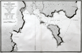 | Details | Duperrey, Louis-Isidore | 1824 |
| Chart of the Harbor of Doreri West Papua New Guinea |
|
Duperrey, Louis-Isidore |
|
| 1824 |
| LOC:59 |
| $500.00 | Duperrey--Louis-Isidore | Chart-of-the-Harbor-of-Doreri-West-Papua-New-Guinea | Copperplate engraved French nautical chart of the bay and harbor of Doreri in the Province of West Papua on the island of New Guinea, Indonesia. Duperrey explored the region in 1793 while searching for the missing expedition of Jean-François de La Pérouse. Shows the route of the Corvette "la Coquille" during July, 1824.
<br><br>
From 'Voyage autour du monde' ('Voyage round the world') by Louis Isidore Duperrey (1826). Plate 34. Engraved by Tardieu.
<br><br>
The bay is on the east coast of West Papua near the city of Manokwari, which is the capital of the province. One notable fact about the Bay of Doreri is that today it is home to Doreri Nature Reserve, which is a protected area encompassing coastal and marine ecosystems.
<br><br>
The chart includes these other nearby locations:
<div class="indenttextblocksingle">
<ul style="list-style-type: circle;">
<li>Point Ambla</li>
<li>Isle Manas-Ouari (Mansinam)</li>
<li>Isle Masmapi</li>
<li>Baie Masinami</li>
<li>Baie Ouahouzi</li>
<li>Cap Ouacalo</li>
</ul>
</div> |