| | Thumbnail | | Creator | Date | Title / Author / Date / Location | Price | | | Description |
| 2488 | 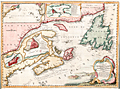 | Details | Bellin, Jacques Nicolas | 1744 |
| Fine decorative chart of eastern Canada |
|
Bellin, Jacques Nicolas |
|
| 1744 |
| LOC:0 |
| $0.00 | Bellin--Jacques-Nicolas | Fine-decorative-chart-of-eastern-Canada | SOLD
<br></br>
Bellin's attractive map of New England and eastern Canada. With insets of the fortified town of Quebec, Fort Dauphin, the city and Port of Louisbourg, and the eastern United States and Canada from Cape Fear northward. The map includes New England as far south as Boston, the St. Lawrence River just beyond Quebec, and north to Cape Round. Very attractive title cartouche with ships and land batteries firing cannon.
<br></br>
Prince Edward Island, one of Canada's three maritime provinces, is labeled "St. Johns" after the original French name "Île Saint-Jean". The island is named for Prince Edward, Duke of Kent, the fourth son of King George III.
<br></br>
Coastal detail features soundings and the fishing banks. This attractive map of Canada was published by N. Bellin in 1744. |
| 683 | 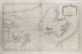 | Details | Depot de la Marine | 1754 |
| Gulf of St. Lawrence |
|
Depot de la Marine |
|
| 1754 |
| LOC:0 |
| $0.00 | Depot-de-la-Marine | Gulf-of-St--Lawrence | SOLD<br></br>
Large antique mid 18th century French nautical chart of the entire Gulf of St. Lawrence. Published by the French Depot des Cartes, Plans et Journaux de la Marine in 1754, this variant example of the chart does not contain an attribution to J.N. Bellin, uncovering Pinquin ( Penguin ) Island in the space previously occupied by the cartouche.
<br></br>
Includes the Island of Newfoundland ( Isle de Terre-Neuve ) with the town of St. John ( St. Jean ), Anticosti Island, the Grand Banks, and Isle Royale. Very interesting is the addition of several very small manuscript? annotations to the chart very near to the Islands of Miquelon and St. Pierre- the only two French possessions in the area. The annotations include the addition of a name to a very small island "Isle Verte" (Green Island) and the overwriting / obscuring of the name for one of the headlands- "le Chapeau Rouge'.
<br></br> |
| 830 | 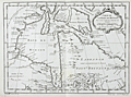 | Details | Bellin, Jacques Nicolas | 1757 |
| Antique French map of Hudson Bay |
|
Bellin, Jacques Nicolas |
|
| 1757 |
| LOC:0 |
| $0.00 | Bellin--Jacques-Nicolas | Antique-French-map-of-Hudson-Bay | SOLD<br></br>
Fascinating antique French map records Britain's dominions in the Northeast before the U.S. Revolutionary war. Coverage includes portions of the Canadian provinces of Nunavut, Manitoba, Ontario, and Quebec along with Hudson Bay, the second largest bay in the world after the Bay of Bengal. Noted features include Repulse Bay, James Bay, Labrador, the Isle de Bonne Fortune, Hudson Strait, and Cumberland Bay.
<br></br>
Along the shores of lower James Bay are several forts including Fort Albany, Fort de St. Louis, Fort Rupert. The bay is named after British explorer Henry Hudson who discovered the bay while searching for the Northwest Passage under the auspices of the Virginia Company and the British East India Company. Hudson and a few of his men were set adrift and marooned in Hudson's Bay in June of 1611 by mutineers among the crew of his ship, the Discovery.
<br></br>
This map is from Bellin's Histoire Generale des Voyages. |
| 661 |  | Details | Depot de la Marine | 1822 |
| Plan of Saint George's Bay Newfoundland |
|
Depot de la Marine |
|
| 1822 |
| LOC:65 |
| $375.00 | Depot-de-la-Marine | Plan-of-Saint-George-s-Bay-Newfoundland | Beautiful copperplate-engraved chart of the interior of St. George's Bay near the present-day towns of Stephenville and Saint George's on the Southwest coast of Newfoundland. Early 19th century working sea chart of area near the Gulf of St. Lawrence produced by the French Depot de la Marine after the work of two French Naval officers: Saulnier de Vauhello and Begon de la Rouziere. Noted points of interest include Cap Sauvage, Flat Island ( Point de Sable ), and Riviere Saint George. Numerous soundings and hydrographical features.
<br></br>
With the circular logo of France's Depot General de la Marine. Price Two Francs. No. 148. |
| 385 | 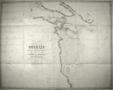 | Details | Parry, William Edward | 1824 |
| Chart of a part of the North Eastern Coast of America [North] |
|
Parry, William Edward |
|
| 1824 |
| LOC:53 |
| $450.00 | Parry--William-Edward | Chart-of-a-part-of-the-North-Eastern-Coast-of-America-[North] | A large chart of the Melville Peninsula and its adjacent islands, including Amherst, Liddon, and Ormond Islands. The chart documents the expedition of the vessels Fury and Hecla from 1822-1823 led by William Edward Parry to find a Northwest passage to the Pacific. Contains the route of the expedition's ships with Cape Englefield and Cape Hallowell off the Fury and Hecla strait as the western-most point. <BR> </BR>
Foldout steel engraving from: "Journal of a second voyage for the discovery of a north-west passage from the Atlantic to the Pacific; performed in the years 1821-22-23, in his Majesty's ships Fury and Hecla, under the orders of William Edward Parry, … ". Published by John Murray, Albemarle Street, London. January 6th, 1824. |
| 386 |  | Details | Parry, William Edward | 1824 |
| Chart of the Northern Shore of Hudson's Strait |
|
Parry, William Edward |
|
| 1824 |
| LOC:53 |
| $400.00 | Parry--William-Edward | Chart-of-the-Northern-Shore-of-Hudson-s-Strait | A large chart of upper Hudson's Strait from Nottingham Island to Resolution Island. The chart documents the expedition of the vessels Fury and Hecla from 1821-1823 led by William Edward Parry to find a Northwest passage to the Pacific. During that expedition Parry explored Repulse Bay and discovered what is now Fury and Hecla Strait. Contains the route of the expedition's ships. <BR> </BR>
Foldout steel engraving from: "Journal of a second voyage for the discovery of a north-west passage from the Atlantic to the Pacific; performed in the years 1821-22-23, in his Majesty's ships Fury and Hecla, under the orders of William Edward Parry, … ". Published by John Murray, Albemarle Street, London. January 6th, 1824. |
| 387 |  | Details | Parry, William Edward | 1824 |
| Chart of a part of the North Eastern Coast of America [South] |
|
Parry, William Edward |
|
| 1824 |
| LOC:53 |
| $450.00 | Parry--William-Edward | Chart-of-a-part-of-the-North-Eastern-Coast-of-America-[South] | A large chart of Northeastern America with Repulse Bay as the Western-most point.. The chart documents the expedition of the vessels Fury and Hecla from 1821-1822-1823 led by William Edward Parry to find a Northwest passage to the Pacific. During that expedition Parry explored Repulse Bay and discovered what is now Fury and Hecla Strait. Other geographical features on this chart include Cape Frigid, Duke of York Bay, Frozen Strait, Gore Bay, Ross Bay, and Lyon Inlet. <BR> </BR>
Foldout steel engraving from: "Journal of a second voyage for the discovery of a north-west passage from the Atlantic to the Pacific; performed in the years 1821-22-23, in his Majesty's ships Fury and Hecla, under the orders of William Edward Parry, … ". Published by John Murray, Albemarle Street, London. January 6th, 1824. |
| 4865 | 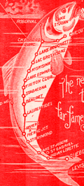 | Details | Quebec and Lake St. John Railway | 1898 |
| Antique Quebec and Lake St. John Railway map |
|
Quebec and Lake St. John Railway |
|
| 1898 |
| LOC:13 |
| $0.00 | Quebec-and-Lake-St--John-Railway | Antique-Quebec-and-Lake-St--John-Railway-map | SOLD
<br></br>
Antique panoramic birds-eye view of the Quebec and Lake St. John Railway route between those two locations. A folding lithographed brochure (closed 8" x 3") filled with interesting pictorial
Illustrations including steamboats, waterfalls, native Montagnais Indians and:
<div class="indenttextblocksingle">
<ul style="list-style-type: circle;">
<li>Chateau Frontenac Quebec</li>
<li>Princess Louise Basic and Dock, Quebec</li>
<li>Lake Saint Joseph</li>
<li>Batiscan River</li>
<li>Jeannotte River. Outlet of Lake Edward</li>
<li>Wharf at Chicoutimi and By Station</li>
<li>The Sidewheel Steamer Mistassini</li>
</ul>
</div>
Printed in Canada.
<br></br>
Shows the entire railway route as it stretches east with key locations as far east as Ha-Ha Bay, Chicoutimi, Grand Discharge, and St. Felicien.
<br></br>
<img src="/ZoomifyImages/SC_4865/SC_4865_Cover.jpg" alt="Fine cover with a fish bearing a railway route map." width="120" align="right" style="margin: 0px 0px 10px 0px">
Be sure to take a good look at the cover, it’s a work of art. Dated within to 1898. Verso with train schedules, timetables and general information. |
| 4966 | 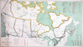 | Details | Canada Department of the Interior | 1911 |
| Antique Map of the Dominion of Canada |
|
Canada Department of the Interior |
|
| 1911 |
| LOC:1112 |
| $400.00 | Canada-Department-of-the-Interior | Antique-Map-of-the-Dominion-of-Canada | Antique map of the Dominion of Canada, with an emphasis on the Canadian Railroads, published by Canada's Department of the Interior . A reduced edition of the "Railway Map of the Dominion of Canada" aa much larger work of eight sheets totaling 100 inches in length.
<br></br>
Ottawa. R.E. Young, D.L.S. Chief Geographer.
<br></br>
Table at right shows a total of 1869 of track miles constructed in the Dominion of Canada during 1910 broken down into railway systems including:
<div class="indenttextblocksingle">
<ul style="list-style-type: circle;">
<li>Canadian Northern</li>
<li>Canadian Pacific</li>
<li>Grand Trunk Pacific</li>
<li>National Transcontinental</li>
<li>Algoma Central and Hudson Bay</li>
<li>Atlantic Quebec and Western</li>
<li>Sundry Railways</li>
</ul>
</div> |
| 4968 | 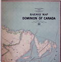 | Details | Canada Department of the Interior | 1911 |
| Railway Map of the Dominion of Canada |
|
Canada Department of the Interior |
|
| 1911 |
| LOC:0 |
| $700.00 | Canada-Department-of-the-Interior | Railway-Map-of-the-Dominion-of-Canada | Scarce antique railway map of the entire Dominion of Canada, from coast to coast, a work of eight sheets roughly totaling about 104 inches in length inside the neatline, over 9 feet wide including the margins. Call for complete photo set and condition report. No sale of this map is recorded in AMPR. No holdings of the 1911 edition of the Railway Map were found in WorldCat (1 holding of the 1910 edition).
<br></br>
Ottawa. R.E. Young, D.L.S. Chief Geographer. Scale 35 miles to one inch.
<br></br> |
| 5178 | 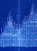 | Details | Canadian Pacific Railroad | 1915 |
| Cyanotype transcontinental elevation profile for Canadian Pacific Railroad |
|
Canadian Pacific Railroad |
|
| 1915 |
| LOC:62 |
| $0.00 | Canadian-Pacific-Railroad | Cyanotype-transcontinental-elevation-profile-for-Canadian-Pacific-Railroad | SOLD
<br></br>
Fascinating cyanotype, or blueprint, transcontinental elevation profile for the Canadian Pacific Railroad (CPR) ca. 1915. Shows the elevation of the CPR line stretching Montreal (bottom right) to Vancouver, Canada (top left). At a horizontal scale of 1" = 30 miles and vertical scale of 1" = 1000 feet the chart clearly represents the vast distance across Canada as well as the challenges imposed by the Rocky Mountains and the Selkirk Mountain Range.
<br></br>
Date was obtained by analysis of the profile at Rogers Pass on the Selkirk Range where a tunnel is shown under construction. The tunnel at that point fits the Connaught Tunnel which was built to replace the route over Roger's Pass. The Connaught Tunnel is known to have been under construction from April 2, 1914 until December 16, 1916 when it began operational service. |
| 4951 |  | Details | British Admiralty Hydrographical Office | 1919 |
| Antique Admiralty chart of Vancouver, B.C. and Burrard Inlet |
|
British Admiralty Hydrographical Office |
|
| 1919 |
| LOC:65 |
| $1,450.00 | British-Admiralty-Hydrographical-Office | Antique-Admiralty-chart-of-Vancouver--B-C--and-Burrard-Inlet | Original antique British Admiralty nautical chart of Burrard Inlet and Vancouver in British Columbia, Canada. The large chart sheet includes detailed larger-scale inset charts of Vancouver Harbor, the First Narrows, and the Second Narrows. This nautical chart was first published by the British Admiralty in 1893. This is the edition of 1917 with last corrections to 1919. Canada.
<br></br>
In June 1890, while outbound for the Orient from Burrard Inlet, BC the Canadian Pacific Railway steamer Parthia touched a shoal, incurring minor damage. The incident caused the Dominion government to recommend that the inlet be resurveyed and in April 1891 William J. Stewart arrived in Vancouver, British Columbia to lead the effort which lasted until September of that year. Traveling an estimated 75 miles of shoreline on foot and sounding over 450 miles by whaleboat, Stewart accomplished the survey of Burrard Inlet for less that $2,600. (https://www.cnrs-scrn.org/northern_mariner/vol14/tnm_14_1_7-42.pdf) |
| 4937 |  | Details | British Admiralty Hydrographical Office | 1925 |
| Awesome Chart of Vancouver Island Washington Territory |
|
British Admiralty Hydrographical Office |
|
| 1925 |
| LOC:65 |
| $875.00 | British-Admiralty-Hydrographical-Office | Awesome-Chart-of-Vancouver-Island-Washington-Territory | Very fine British Admiralty chart of Vancouver Island, the Strait of Juan de Fuca, San Juan Islands, the Washington Territory, Bellingham. An early 20th century copper-engraved chart with very fine detail. The topography and presentation are based on an earlier edition from the mid-19th century, with corrections as noted. With six fine inset elevation views of the coast.
<br/><br/>
"North America … West Coast … VANCOUVER ISLAND and Adjacent Shores of British Columbia Surveyed by Captain G.H. Richards, R.N." … First published by the Admiralty on Sept 25, 1865. Large corrections in 1890 and 1900 with last correction in 1925. Chart # 1917.
<br/><br/>
'Sir George Henry Richards (1820 –1896) was hydrographer to the British Admiralty from 1864 to 1874.
After joining the Royal Navy in 1832, Richards was a hydrographer on the coast of British Columbia in 1857–1862 and was the second British commissioner to the San Juan Islands Boundary Commission. Richards is responsible for the selection and designation of dozens of placenames along the British Columbia coast.
<br/><br/>
Richards conducted surveys in the Pacific Northwest aboard the survey ships Plumper, and later the Hecate. As second commissioner for the maritime boundary, he was tasked with a detailed survey of the waters between Vancouver Island and the American mainland, to help determine the location of the international boundary through the San Juan Islands. The survey was completed in June 1858.' (Dictionary of Canadian Biography. http://www.biographi.ca/en/bio.php?id_nbr=6394). |
| 4945 |  | Details | New York Central Railroad | 1927 |
| MS Rate Map for Quebec Central Railway Company Pulpwood |
|
New York Central Railroad |
|
| 1927 |
| LOC:200 |
| $250.00 | New-York-Central-Railroad- | MS-Rate-Map-for-Quebec-Central-Railway-Company-Pulpwood | Very cool manuscript U.S.A. railroad route rate map for a Canadian railroad: "Map of the Quebec Central Railway Company showing rates on Pulpwood, Carloads from Quebec Central Railway Stations to Watertown- Boonville - Fulton and Lockport, N.Y. U.S.A. 1927."
<br></br>
Compiled by H.W. Schatt, General Freight Office, N.Y.C.R.R. January, 1927. Very neat, tidy lettering.
<br></br>
The Quebec Central Railway served the area of Quebec called the Eastern Townships, south of the St. Lawrence River. Its headquarters was in Sherbrooke. It was originally incorporated in 1869 as the Sherbrooke, Eastern Townships and Kennebec Railway, and changed its name to the Quebec Central Railway in 1875.
<br></br>
Interesting in that the map was produced by the New York Central Railroad probably for their own internal use. |
| 6469 |  | Details | Page, Peter Hugh | 1936 |
| Fine pictorial maps of British Columbia for Home Gas |
|
Page, Peter Hugh |
|
| 1936 |
| LOC:150 |
| $0.00 | Page--Peter-Hugh | Fine-pictorial-maps-of-British-Columbia-for-Home-Gas | SOLD<br><br>Unrecorded, extraordinary, even spectacular pictorial map of British Columbia for Home Gas. The map was produced by artist Peter Hugh Page toward the end of the Great Depression (1936).
<br><br>
<div class="indenttextblock"><strong>
"Home Gas here offers you a map sensational!! <br>British Columbia is the province shewn. <br>And when you're feeling thoroughly vacational. <br>Pay us a visit and treat the place like home."</strong>
</div><br>
<div id="0" align="center">
<a title="Peter Hugh Page B.C. map details"></a>
<img id="1" src="/ZoomifyImages/SC_6469/SC_6469_details.jpg" alt="Hugh Page B.C. pictorial map details." width="330"/> <br><small>Pictorial B.C. road map details by Peter Hugh Page</small>
</div><br>
Folding brochure (max. 26" x 20") with two similarly attractive smaller pictorial maps (each map 13" x 10") on the verso for Victoria, B.C. and for Vancouver, B.C.
<br><br>
<div id="0" align="center">
<a title="Peter Hugh Page map of Vancouver"></a>
<img id="1" src="/ZoomifyImages/SC_6469/SC_6469_Vancouver.jpg" alt="Hugh Page pictorial map of Vancouver from 1836." width="300"/> <br><small>Pictorial road map of Vancouver, B.C. by Peter Hugh Page</small>
</div><br>
<div id="0" align="center">
<a title="Hugh Page map of Victoria B.C."></a>
<img id="1" src="/ZoomifyImages/SC_6469/SC_6469_Victoria.jpg" alt="Hugh Page pictorial map of Victoria from 1936." width="300"/> <br><small>Pictorial road map of Victoria, B.C. by Peter Hugh Page</small>
</div><br> |
| 6500 | 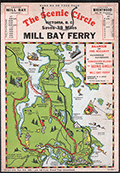 | Details | Page, Peter Hugh | 1936 |
| Rare pictorial map of Victoria, British Columbia with Ferry Routes |
|
Page, Peter Hugh |
|
| 1936 |
| LOC:78 |
| $350.00 | Page--Peter-Hugh | Rare-pictorial-map-of-Victoria--British-Columbia-with-Ferry-Routes | Rare pictorial auto map of Victoria, Vancouver Island, British Columbia, Canada featuring the Mill Bay Ferry route as an element of the Scenic Circle auto route. The map features numerous small cartoonish drawings of local activities including golfing, hunting, fishing, gardening, and horse racing. No holdings of this rare pictorial auto route map are found anywhere else online, nor any record of sales. Dated within to 1936.
<br><br>
Locations noted on the map include Telegraph Beach, Victoria Golf Club, James Island, Sidney, Sidney Island, Esquimalt Harbor, and Cordova Bay.
<br><br>
On card stock, this unusual piece of cartographic ephemera includes the original string hanger still attached through two punched holes.
<br><br>
Recto with departure times for the Mill Bay Ferry from both Malahat and from Brentwood. Verso with a photo of the ferry - M.S. Cascade, an inset smaller-scale sketch map of the Victoria surrounding area, a mileage table, and text on points of interest and suggestions for the Scenic Circle drive.
<div class="indenttextblocksingle">
"Ferry Trip across the placid waters of Saanich Arm, Sport Fishing preserve, where salmon up to 53-lbs. are taken and over fifty species of fish are found. From the Ferry can be seen Senanus Island, an ancient Indian burial ground, Bamberton Cement Works, Brentwood Cottage".
<br>and<br>
"A glance at the Map on the other side will convince you of the ease and simplicity of this Route. You can save MONEY, TIME and reduce your mileage from 83 to 45 by using this convenient connecting link [ferry] between Mr. BUTCHARTS GARNENS and the Famous MALAHAT DRIVE…"
</div> |
| 6513 | 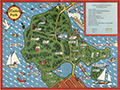 | Details | Page, Peter Hugh | 1940 |
| Fine second edition pictorial map of Stanley Park, Vancouver, British Columbia, Canada |
|
Page, Peter Hugh |
|
| 1940 |
| LOC:78 |
| $350.00 | Page--Peter-Hugh | Fine-second-edition-pictorial-map-of-Stanley-Park--Vancouver--British-Columbia--Canada | Beautiful lithographed pictorial map of Stanley Park, Vancouver, Canada by Peter Hugh Page, ca. 1940. Excellent condition. Second Edition. Shows Prospect Point, Brockton Point, Deadman's Island, Lost Lagoon, Second Beach, Beaver Lake and many other locations and attractions in Stanley Park.
<br><br>
<div align="center">
<a title="Stanley Park Cover"></a>
<img id="3" src="/ZoomifyImages/SC_6513/SC_6513_detail.jpg" alt="Cover from a brochure on Stanley Park, Vancouver, Canada by Peter Hugh Page in 1940." width="175"/> <br><small>Cover from Page's map of Stanley Park</small>
</div><br>
The second edition of Page's map of Stanley Park differs from the first edition in that it includes a depiction of the Lion's Gate Bridge (built 1939) and the label for Siwash Rock is removed. Verso with text about Stanley Park. |
| 7957 | 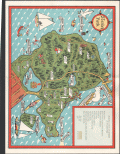 | Details | Page, Peter Hugh | 1941 |
| Rare third edition pictorial map of Stanley Park, Vancouver, British Columbia, Canada |
|
Page, Peter Hugh |
|
| 1941 |
| LOC:41 |
| $350.00 | Page--Peter-Hugh | Rare-third-edition-pictorial-map-of-Stanley-Park--Vancouver--British-Columbia--Canada | Beautiful lithographed pictorial map of Stanley Park, Vancouver, Canada by Peter Hugh Page, ca. 1941. Third Edition of three known editions by Peter Page. Shows Prospect Point, Brockton Point, Deadman's Island, Lost Lagoon, Second Beach, Beaver Lake and many other locations and attractions in Stanley Park.
<br><br>
<div align="center">
<a title="Stanley Park Cover"></a>
<img id="3" src="/ZoomifyImages/SC_6513/SC_6513_detail.jpg" alt="Cover from a brochure on Stanley Park, Vancouver, Canada by Peter Hugh Page in 1940." width="175"/> <br><small>Cover from Page's map of Stanley Park</small>
</div><br>
The third edition of Page's map of Stanley Park differs from the first and second editions in that it includes a label for Siwash Rock; the map shows, for the first time, the Illuminated Fountain built ca. 1936 in Lost Lagoon; and shows the Royal Vancouver Yacht Club site on Deadman's Island. Verso with text about Stanley Park. |
| 5019 |  | Details | Canadian Pacific Railroad | 1941 |
| Map of Banff Lake Louise Columbia Icefield Highway Glaciers |
|
Canadian Pacific Railroad |
|
| 1941 |
| LOC:10 |
| $350.00 | Canadian-Pacific-Railroad | Map-of-Banff-Lake-Louise-Columbia-Icefield-Highway-Glaciers | Attractive and very scarce lithographed map of Banff, Lake Louise and the Columbia Icefield Highway with the Yoho Valley Emerald Lake Field, and Golden, Canada. Shows highways, glaciers, mountain ranges, trails, and the route of the Canadian Pacific Railway.
<br></br>
Map is on the recto of a folding six-part brochure with an inset elevation view of the "Altitudes of principal peaks from Golden to Banff in the Canadian Rockies." In that view the peaks with names underlined are on the South Side of the Canadian Pacific Railway main line from Banff to Golden.
<br></br>
Verso contains photographs, text and a map of the Columbia Icefield Highway (Sunwapta Pass to Lake Louise) and a cross section (elevation view) of the Canadian Rockies from the same Columbia Icefield Highway. Dated by reference to the Rumsey Collection. |
| 1190 |  | Details | Davenport, Joseph B. | 1941 |
| Southern Districts of Vancouver Islands and Adjacent Gulf Islands |
|
Davenport, Joseph B. |
|
| 1941 |
| LOC:0 |
| $850.00 | Davenport--Joseph-B- | Southern-Districts-of-Vancouver-Islands-and-Adjacent-Gulf-Islands | Very large whiteprint or blue-line map of Southern Vancouver Island, British Columbia. First printed in 1932, this revised edition dates from 1941. Inset map of Saturna Island. Contains cadastral and road detail with a road index at center left. Laid to linen and on rollers; no folds.
<br></br>
Coverage includes Ladysmith, Duncan, Victoria, Sidney, portions of Juan de Fuca Strait, Strait of Georgia, Galiano Island, Mayne Island, North and South Pender Island, and numerous other islands and passages in that area.
<br></br>
Contains a red-stamped notation: "Pocket copies of this map may be obtained at the office--". Manuscript pencil course line and distances drawn from top of map near Kulleet Bay, through Stuart Channel and Haro Strait to Victoria Harbor.
<br></br>
Copyrighted in Canada 1932 by Joseph Davenport. Printed by the Island Blue Print and Map Company, Victoria, B.C. |
| 5368 |  | Details | Money, Anton | 1943 |
| Rare cyanotype pictorial map Whitehorse, Yukon Territory, Canada |
|
Money, Anton |
|
| 1943 |
| LOC:55 |
| $1,250.00 | Money--Anton | Rare-cyanotype-pictorial-map-Whitehorse--Yukon-Territory--Canada | Very rare satirical, cyanotype pictorial view of the town of Whitehorse in the Yukon Territory of Canada dated within to October, 1943. A folk-art style humorous blueprint, bird's eye view of the city of Whitehorse by engineer Anton Money.
<br></br>
The view includes numerous annotated humorous scenes of daily life in Whitehorse including a Mountie dog-sled team, gold panning, gambling, drinking, whoring, the White Pass and Yukon Route narrow gauge railway and the Whitehorse railway station.
<br></br>
By explorer Anton Money with acknowledgements to Louis McCormick and Don Reikard.
<br></br>
No recorded sales or holdings of this view except for one copy at the library of the University of Calgary in Canada. |
| 6543 | 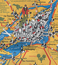 | Details | Turner, Stanley | 1948 |
| Pictorial map Laurentides region Montreal, Canada Stanley Turner 1948 |
|
Turner, Stanley |
|
| 1948 |
| LOC:300 |
| $500.00 | Turner--Stanley | Pictorial-map-Laurentides-region-Montreal--Canada-Stanley-Turner-1948 | Historical-pictorial map of the Laurentides region of Canada with Montreal by Stanley Francis Turner, 1948. A tourist-oriented map published by Brading Brewery designed to encourage vacationers to visit Montreal and the Laurentides region of Canada.
<br><br>
<div id="1" align="center">
<a title="Montreal, Canada"></a>
<img id="1" src="/ZoomifyImages/SC_6543/SC_6543_detail.jpg" alt="Stanley Turner pictorial view of Montreal, Canada from 1948 Brading Brewery map." width="340"/> <br><small>Stanley Turner pictorial view of Montreal, Canada.</small>
</div>
<br>
Copyright 1948 Bradings Capital Brewery Ltd. Ottawa, Canada. French language.
<br><br> |
| 6542 | 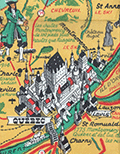 | Details | Turner, Stanley | 1948 |
| Pictorial map Saguenay region Quebec, Canada Stanley Turner 1948 |
|
Turner, Stanley |
|
| 1948 |
| LOC:300 |
| $400.00 | Turner--Stanley | Pictorial-map-Saguenay-region-Quebec--Canada-Stanley-Turner-1948 | Historical-pictorial map of the Saguenay region of Canada with Quebec by Stanley Turner, 1948. A tourist-oriented map published by Brading Brewery designed to encourage vacationers to visit the Saguenay area.
<br><br>
<div id="1" align="center">
<a title="TITLE HERE"></a>
<img id="1" src="/ZoomifyImages/SC_6542/SC_6542_detail.jpg" alt="Stanley Turner pictorial view of Quebec from Brading Brewery map 1948" width="340"/> <br><small>Stanley Turner pictorial view of Quebec.</small>
</div><br>
<div class="indenttextblocksingle">
"This map represents Bas-Saint-Laurent and Saguenay. A lot of information is offered on the map, such as main arteries, railroads, golf clubs, airports, crossings, battlefields, hydroelectric installations and hunting and fishing spots. Some historical information is also added such as dates of battles and discovery of territories. Drawings of inhabitants, animals or historical figures decorate the document."
</div><br>
Copyright 1948 Bradings Capital Brewery Ltd. Ottawa, Canada. French language.
<br><br>
[1] Online. https://archivesdemontreal.ica-atom.org/carte-de-vacances-brading-du-bas-st-laurent-et-de-la-region-de-saguenay-1949 |
| 5168 | 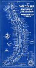 | Details | Batson, E. Bert | 1948 |
| Cyanotype Map Sable Island Graveyard of the Atlantic Shipwrecks |
|
Batson, E. Bert |
|
| 1948 |
| LOC: |
| $0.00 | Batson--E--Bert | Cyanotype-Map-Sable-Island-Graveyard-of-the-Atlantic-Shipwrecks | <a href="https://www.rarecharts.com/ShowDetail/Creator/Batson--E--Bert/Title/Sable-Island-Canada-Map-Graveyard-of-Atlantic-Shipwrecks-Cyanotype/5404" target="_blank">This chart is SOLD but see another example of the Sable Island chart in our inventory.</a>
<br></br>
Interesting, original cyanotype map "Sable Island Graveyard on the Atlantic Shipwrecks Since 1800", sold by E. Bert Batson, but after a design by Donald S. Johnson, a member of the Sable Island Lifeboat Organization. |
| 5404 | 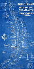 | Details | Batson, E. Bert | 1948 |
| Sable Island Canada Map Graveyard of Atlantic Shipwrecks Cyanotype |
|
Batson, E. Bert |
|
| 1948 |
| LOC: |
| $0.00 | Batson--E--Bert | Sable-Island-Canada-Map-Graveyard-of-Atlantic-Shipwrecks-Cyanotype | SOLD<br><br>
Scarce, original cyanotype chart <strong>"Sable Island, Graveyard on the Atlantic, Shipwrecks Since 1800"</strong>, only the second copy we have seen in 12 years!
<br><br>
Sold by E. Bert Batson, but after a design by Donald S. Johnson, a member of the Sable Island Lifeboat Organization. Copyrighted by R. Ian McDonald; in Canada 1938; in U.S.A. June 1948. Only one holding in WorldCat.
<br></br>
In 1916 E. Bert Batson started in Halifax, Nova Scotia as a junk dealer after a varied career as a soldier, sailor, and bank messenger. Batson bought from estate and Admiralty sales, auctions and other secondhand sources, selling his wares from a location on the Halifax waterfront, later moving to 36-38 Lower Water Street. His motto was <b>"Everything from a needle to an anchor."</b><br></br>
<div id="0" align="center">
<a title="TITLE HERE"></a>
<img id="3" src="/zoomifyimages/SC_5404/BertBatson.gif" alt="Bert Batson's store in Halifax, Nova Scotia." width="300"/> <br><small>Bert Batson's storefront in Halifax, Nova Scotia.</small>
</div><br>
Here's a few paragraphs from a 1946 profile of Bert from Maclean's magazine:
<div class="indenttextblock">
You may know of Bert. A lot of people do. He’s the “Needle To An Anchor” man. His store on Lower Water Street in Halifax is a fabulous place... it’s a combination junk yard, ship chandler’s, department store, antique dealer’s, curio collector’s heaven and commission broker’s. Its customers include shipping men, souvenir hunters, antique collectors and a lot of other people in America and Europe and everybody in Halifax. And it’s likely to sell them anything from secondhand rolled oats, discarded gold mines, kidney pills or unmarketable fish, to shower curtains, ship’s lanterns, conveyer belts, Epsom salts and used bathtubs.
</br>
(Online: O'Hearn, D. P. Maclean's Magazine, November 15, 1946.)
</div> |
| 6662 | 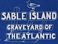 | Details | Batson, E. Bert | 1948 |
| Bert Batson Sable Island Canada Map Graveyard of Atlantic Shipwreck |
|
Batson, E. Bert |
|
| 1948 |
| LOC:53 |
| $0.00 | Batson--E--Bert | Bert-Batson-Sable-Island-Canada-Map-Graveyard-of-Atlantic-Shipwreck | SOLD<br><br>
Original blueprint chart <strong>"Sable Island, Graveyard on the Atlantic, Shipwrecks Since 1800"</strong>, only the third copy we have seen in 12 years!
<br><br>
Sold by E. Bert Batson, but after a design by Donald S. Johnson, a member of the Sable Island Lifeboat Organization. Copyrighted by R. Ian McDonald; in Canada 1938; in U.S.A. June 1948. Only one holding in WorldCat.
<br></br>
In 1916 E. Bert Batson started in Halifax, Nova Scotia as a junk dealer after a varied career as a soldier, sailor, and bank messenger. Batson bought from estate and Admiralty sales, auctions and other secondhand sources, selling his wares from a location on the Halifax waterfront, later moving to 36-38 Lower Water Street. His motto was <b>"Everything from a needle to an anchor."</b><br></br>
<div id="0" align="center">
<a title="TITLE HERE"></a>
<img id="3" src="/zoomifyimages/SC_5404/BertBatson.gif" alt="Bert Batson's store in Halifax, Nova Scotia." width="300"/> <br><small>Bert Batson's storefront in Halifax, Nova Scotia.</small>
</div><br>
Here's a few paragraphs from a 1946 profile of Bert from Maclean's magazine:
<div class="indenttextblock">
You may know of Bert. A lot of people do. He’s the “Needle To An Anchor” man. His store on Lower Water Street in Halifax is a fabulous place... it’s a combination junk yard, ship chandler’s, department store, antique dealer’s, curio collector’s heaven and commission broker’s. Its customers include shipping men, souvenir hunters, antique collectors and a lot of other people in America and Europe and everybody in Halifax. And it’s likely to sell them anything from secondhand rolled oats, discarded gold mines, kidney pills or unmarketable fish, to shower curtains, ship’s lanterns, conveyer belts, Epsom salts and used bathtubs.
</br>
(Online: O'Hearn, D. P. Maclean's Magazine, November 15, 1946.)
</div> |
| 6382 |  | Details | VX9A | 1975 |
| Scarce map of Sable Island, Nova Scotia in the form of a QSL card. |
|
VX9A |
|
| 1975 |
| LOC:78 |
| $150.00 | VX9A | Scarce-map-of-Sable-Island--Nova-Scotia-in-the-form-of-a-QSL-card- | Scarce pictorial map of Sable Island, Nova Scotia, Canada as a QSL card. A QSL card is a written confirmation of two-way radiocommunication between two amateur radio stations, in this case between VX9A on Sable Island and W4UW on the 40 mhz (shortwave band) on November 2, 1975.
<br></br>
On card stock with one vertical and two horizontal folds, as issued. Verso with text and halftone images. |
| 6812 |  | Details | Bates, George T. | 1975 |
| Megumaage Micmac Indian Historical Map of Nova Scotia |
|
Bates, George T. |
|
| 1975 |
| LOC:10101 |
| $0.00 | Bates--George-T- | Megumaage-Micmac-Indian-Historical-Map-of-Nova-Scotia | SOLD<br><br>
A fine blueprint-style historical map of Nova Scotia, Canada with English and the Micmac (Mi'kmaq) Indian language place name translations. Scarce. Shows the locations of Micmac campsites and shell middens including the Indian Gardens and Gaspereaux River campsites.
<br><br>
Compiled, copyrighted, and drawn by Nova Scotia surveyor George T. Bates. Undated but ca. 1975. Apparently this map is a later edition of the map by Bates that was first issued in 1965. Bates is also credited with "A New Series of Historical Maps of Nova Scotia."
<br><br>
Contains tables with translations of Micmac names for the months and seasons, birds, numbers, trees, and the Lord's Prayer. Additional tables at bottom left with time series data for Micmac population in Nova Scotia and information about the land area and location of Micmac Indian Reserves in Nova Scotia.
<br><br>
Only two examples of this map are recorded in WorldCat.
<br><br>
The author describes the extent of Micmac habitation:
<div class="indenttextblocksingle">
"The Micmacs occupied not only the whole of the Province of Nova Scotia including Cape Breton but also the northern and eastern provinces of New Brunswick and the nearby Prince Edward Island. They are a branch of the Algonquins, which includes all the tribes along the Atlantic Coast from Virginia to Labrador. The Micmac territory was divided into separate districts, each having its own chief. The Indian name for their territory was Megumaage, meaning Micmacland or "the home of the Micmacs."
</div> |