| | Thumbnail | | Creator | Date | Title / Author / Date / Location | Price | | | Description |
| 4816 | 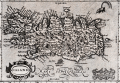 | Details | Mercator-Hondius | 1608 |
| Miniature version of Mercator's Iceland |
|
Mercator-Hondius |
|
| 1608 |
| LOC:77 |
| $350.00 | Mercator-Hondius | Miniature-version-of-Mercator-s-Iceland | Original antique map of Iceland from the French-text edition of Jodocus Hondius' Atlas Minor, published from Amsterdam.
<br></br>
Decorative title cartouche with title "Island" and a different title "Islandia" above. Page 27. French text on verso.
<br></br>
A fine smaller version of Mercator's earlier and larger map of Iceland based on the cartography of the Bishop of Hólar, Gudbrandur Thorláksson. Thorlaksson (1541-1627) is credited with producing the first somewhat accurate map of Iceland, published in 1590 by Abraham Ortelius in his Theatrum Orbis Terrarum.
<br></br>
A spouting sea creature is shown in the sea at upper right, while ashore Mount Hekla "Hekla Mons" is shown erupting with massive flames and boulders. Partly legible notation at Mount Hekla appears to read "perpetus" suggests the volcano erupted constantly at the time. |
| 1481 | 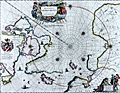 | Details | Blaeu, Johannes | 1645 |
| North Polar Region or Regiones Sub Polo Arctico |
|
Blaeu, Johannes |
|
| 1645 |
| LOC:52 |
| $1,900.00 | Blaeu--Johannes | North-Polar-Region-or-Regiones-Sub-Polo-Arctico | Beautiful engraved map of the North Polar region with fine color. With rhumb lines radiating from the North Pole, a large title cartouche, two figures and numerous wind heads, compass roses, ships and an additional vignette of explorers. Arctic animals shown include a polar bear and foxes. With Backer's coat-of-arms in "Nova Britannia." French text on verso regarding the "Pole Arctique".
<br></br>
Blaeu's map of the North Pole region is a close copy of Jansson's Nova et Accurata Poli Artici based on the arctic map of Barentsz, Baffin, and others. This is state two of the map with Willem Backer's coat-of-arms. |
| 6701 | 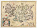 | Details | Blaeu, William Janszoon | 1650 |
| Tabula Islandiae Auctore Georgio Carolo Flandro |
|
Blaeu, William Janszoon |
|
| 1650 |
| LOC:86 |
| $700.00 | Blaeu--William-Janszoon | Tabula-Islandiae-Auctore-Georgio-Carolo-Flandro | A fine 17th century map of Iceland priced to sell.
<br><br>
This map of Iceland, "Tabula Islandiae Auctore Georgio Carolo Flandro", was engraved for William Janszoon Blaeu and first published in his firm’s Atlas Novus. The plate is based on surveys by the Dutch navigator Georgius Carolus Flandrus (Joris Carolus), one of the few early European seafarers to chart northern waters. The map depicts Iceland with stylized mountain ranges, rivers, and settlements identified in Latin and Icelandic. Surrounding seas are filled with ships and sea creatures, and a large title cartouche occupies the lower right. The imprint “Guiljelmus Blaeuw” identifies the plate as one originally engraved for Willem before his death in 1638.
<br><br>
The verso text, printed in Dutch, places this example within the early Dutch-language edition of the Toonneel des Aerdrycks issued in Amsterdam around 1648–1650, when the Blaeu firm was transitioning from William to his son Joan. Printed from the original copperplate, this state retains the strong, clean impression of the earliest issues and represents one of the most well known mid seventeenth-century maps of Iceland. The map’s enduring design remained in use for more than two decades and set the cartographic standard for the island until the late eighteenth century.
<br><br> |
| 4825 | 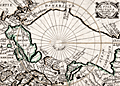 | Details | Picart, Jean | 1657 |
| Scarce original engraving of the North Polar Region |
|
Picart, Jean |
|
| 1657 |
| LOC:13 |
| $480.00 | Picart--Jean | Scarce-original-engraving-of-the-North-Polar-Region | Picart's map of the North Pole (second state) based on Jansson's Septentrionalium Terrarum Descript from the Atlas Minor. An early map of the Arctic region seldom found in this fine condition. |
| 917 | 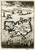 | Details | Mallet, Allain Manesson | 1683 |
| Antique map of Iceland with Greenland |
|
Mallet, Allain Manesson |
|
| 1683 |
| LOC:0 |
| $0.00 | Mallet--Allain-Manesson | Antique-map-of-Iceland-with-Greenland | SOLD
<br><br/>
Charming antique map of Iceland (Islande) with a profile view of Greenland (Groenland) in the background. Between the two islands is a scene of several whaling vessels hunting and harpooning very large whales from whaleboats. By Allain Mallet, Paris, 1683.
<br></br>
Towns depicted include Reykjavík ("Rikiaves"), Holar ("Hola"), Kopavogur ("Koplavnik"), and "Bestede". Mount Hekla ("Mont Hecla") is shown erupting vigorously and numeous other vocanic cones are depicted in the interior. A recorded eruption of Mount Hekla that began in May 1636 lasted over one year.
<br></br>
Published by Mallet in "Description de l'Univers" . Allain Mallet (1630-1706) was a French engineer, soldier, and cartographer. He served in the court of King Louis XIV as a techer of mathematics. In addition to "Description de l'Univers" Mallet also published "Les Travaux de Mars ou l'Art de la Guerre". |
| 3660 | 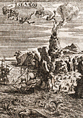 | Details | Mallet, Allain Manesson | 1719 |
| Neat antique view of Iceland |
|
Mallet, Allain Manesson |
|
| 1719 |
| LOC:77 |
| $175.00 | Mallet--Allain-Manesson | Neat-antique-view-of-Iceland | Manneson-Mallet's small and very interesting view of Hecla a volcano on Iceland, a Nordic island country in the North Atlantic Ocean. Hekla (Hecla) is a large and active volcano on the south of Iceland, part of a 40 mile long volcanic ridge. |
| 1326 | 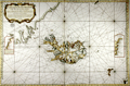 | Details | Bellin, Jacques Nicolas | 1767 |
| Fine antique chart of Iceland and Faroe Islands ... Whaling related |
|
Bellin, Jacques Nicolas |
|
| 1767 |
| LOC:0 |
| $0.00 | Bellin--Jacques-Nicolas | Fine-antique-chart-of-Iceland-and-Faroe-Islands-----Whaling-related | SOLD
<br></br>
Very large antique French sea chart published by France's Depot de la Marine to serve whaling interests near Iceland ("pour servir a la peche de la balaine"). After the work of Horrebows and of Knopf. Contains all of Iceland and portions of the Greenland coast, the Faroe Islands, and Jan Mayen Island. A long stretch of the Greenland coast is noted as speculative: "Toute cette coste n'est tracee que sur des conjectures".
<br></br>
At left an inset correction of a part of Iceland's west coast south of Cap Nord (near today's Hornstrandir Nature Reserve) based on the exploration of Kerguelen in 1707. Inset to right contains coastal details of the east coast of Iceland based on Dutch charts. With a very decorative title cartouche and the circular anchor logo of France's Depot de la Marine. Dated 1767 within but printed ca. 1789 - 1799, based of the "R.F." ( République française ) within the logo.
<br></br>
This scarce and highly decorative chart is annotated with information about re-supply points that could have been useful to whalers and other mariners:
<div class="indenttextblock">
<ul style="list-style-type: circle;">
<li>"Ville et port a viande."</li>
<li>"Ville et port a poisson."</li>
<li>"Ville et port a viande y a aussi boucherie."</li>
<li>"Ville et port ou l'on charge du poisson et de la graisse de poisson."</li>
</ul>
</div>
Contains a diagram noting the high magnetic variation experienced in the area (32 degrees west). Interesting detail is the knitted fisherman's cap directly below the North direction arrow. |