| | Thumbnail | | Creator | Date | Title / Author / Date / Location | Price | | | Description |
| 115 | 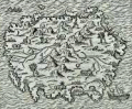 | Details | Thevet, Andre | 1575 |
| Palimbotre |
|
Thevet, Andre |
|
| 1575 |
| LOC:6 |
| $150.00 | Thevet--Andre | Palimbotre | Attractive antique woodblock engraving by Andre Thevet of a perhaps mythical island 'Palimbotre' that he places south of the Ganges River in the Bay of Bengal. About Palimbotre Thevet writes " in this island most of the inhabitants idolize and respect their idols which are made of decorous ebony, where their neighbors of the continent fashion them from marble, stone, sandalwood and other materials" (Conley, Tom. P. 195).<BR> </BR>
Thevet, born around 1516, became a Franciscan friar and wrote extensively about his travels in both the old world and new, widely embellishing the stories and images with myth and fiction. |
| 4700 | 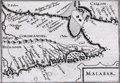 | Details | Bertius, Petrus | 1616 |
| Malabar |
|
Bertius, Petrus |
|
| 1616 |
| LOC:13 |
| $225.00 | Bertius--Petrus | Malabar | Very beautiful early antique miniature map of southern India and a part of Sri Lanka (Ceilon or Ceylon) by Bertius. Numerous towns and villages in India are identified. Important locations within India that are noted by Bertius include: Coromandel, Bisnagor, Goa, Negapatam, Cananor, Calicut (Kozhikode), and Mangalor (Mangaluru),
<br></br>
This lovely copper-plate engraved map is from a Latin edition of Petrus Bertius' <b>Tabularum Geographicarum Contractarum</b>. The basis of the "Tabularum" was the atlas Caert Thresoor by Barent Langenes, first published in 1598.
<br></br>
Latin text on verso. Plate 586. |
| 894 | 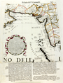 | Details | Coronelli, Vincenzo | 1696 |
| Coronelli's globe gore of the Arabian Sea, India and Maldive Islands |
|
Coronelli, Vincenzo |
|
| 1696 |
| LOC:9 |
| $480.00 | Coronelli--Vincenzo | Coronelli-s-globe-gore-of-the-Arabian-Sea--India-and-Maldive-Islands | Unusual antique hand-colored <b>globe gore</b> by cartographer and Franciscan monk Vincenzo Coronelli (1650 - 1718). Originally produced for <b>Coronelli's 1688 terrestrial globe</b>. This fine engraved gore was included inset with text in his famous island book or "Isolario" published from Venice in 1696 - 1697.
<br></br>
Ranging from Oman, Dubai, and Abu Dhabi, past the Strait of Hormuz and then trending southeast across Iran, Pakistan and the west coast of India this scarce cartographic curiosity includes the Maldive Islands ("Isole Maldive" ) and west coast of Sri Lanka. Among the many noted towns and villages in India are Mumbai ("Bombaim"), <b>Hyderabad ("Golconda")</b> , and Madurai ("Madura").
<br></br>
A globe gore is a 2 dimensional representation on flat paper of a curved segment of the earth's surface. The gores are characterized by their curved top, bottom, and sides. Each gore would have been carefully cut to size and then pasted on a blank globe to produce a finished globe which would have been colored. Typically 12 gores were required to complete the 360 degree circumference of the earth at the latitudes covered by the gore.
<br></br>
We estimate a globe created with this gore would have had a circumference of about 11 feet. (The gore covers roughly 30 degrees of longitude or 1/12 of the earths circumference. At the equator, this gore is 11" wide giving us 11" x 12 = 132" circumference or 11 feet.)
<br></br>
Text on both the recto and verso is Italian. Page 113. |
| 1116 | 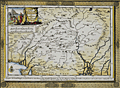 | Details | Aa, Pieter van der | 1713 |
| Antique map of North India or The Empire of the Grand Mogol |
|
Aa, Pieter van der |
|
| 1713 |
| LOC:6 |
| $250.00 | Aa--Pieter-van-der | Antique-map-of-North-India-or-The-Empire-of-the-Grand-Mogol | Attractive antique map by Peter van der Aa of India, the Empire of the Grand Mogol, with the frontiers of Persia and Tartary after the memoires of Nuno de Cunha . Nunho de Cunha, the son of famed Portugese explorer Tristão da Cunha, was the ninth governor of Portuguese possessions in India from 1528 to 1538.
<br></br>
Extends across northern India with parts of Pakistan and Afghanistan. Includes the Indian states of Gujarat ("Guzaratte"), Rajasthan, Madhya Pradesh, and Haryana as well as numerous tributaries to the Ganges and Indus rivers. Key cites noted on the map include Dehli ("Deli"), Ahmedabad ("Hamedebat"), Kabul ("Cabul"), Lahore, Attock, Parvan, Campion, Pitan and numerous others. The map is printed into a finely-engraved decorative frame and will make a handsome presentation when framed.
<br></br>
Pieter van der Aa (1659 - 1733) was a Dutch publisher working in Leiden during the early eighteenth century. He is best known for publishing maps and atlases, though he also printed pirated editions of foreign bestsellers and illustrated volumes. Van de AA's use of stock mock-frame borders is a characteristic for which he is well known. This map shows evidence of two plate marks, one for the mock-frame and the second interior platemark for the smaller map which was printed inside the mock-frame. From "Le nouveau theatre du monde. ou La geographie royale, composée de nouvelles cartes tres-exactes", published from Leiden in 1713. |
| 4854 | 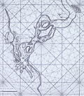 | Details | Valentijn, Francois | 1720 |
| Surat, India |
|
Valentijn, Francois |
|
| 1720 |
| LOC:9 |
| $900.00 | Valentijn--Francois | Surat--India | Scare Dutch chart of the Tapti River and Surat, India. This fine antique chart shows Surat then partially surrounded by a wall and the Casteel Suratta or Surat Castle (built 1546). The author provides numerous depth soundings and great detail on sandbanks in the Tapti River. Such rich detail suggests the source of information on the chart had a significant amount of experience in the area.
<br></br>
From contemporaneous accounts we know that Suratte was a key trading center.
<div class="indenttextblocksingle">
"At one end of the City of Suratte upon the very banks of the river called Tapty you see a very fair castle with four large towers of free-stone with a broad ditch always full of water…there are here three great factories, to wit: of the French, English and Dutch East India Companies, each of which are distinguished by their banners of their respective nations which are to be seen on the tops of their houses."
<br></br>
"But when any European ships arrive at this port, the Persians, Indians, Armenians, and Turks, plant their tents or booths in such numbers, as to give it the resemblance of a very handsome fair." (Rennefort, Crull, Dellon. A Voyage to the East Indies… 1698. Google Books. Online)
</div>
<br></br>
From François Valentyn's Oud en Nieuw Oost Indien (Old and New East India), part V : Beschryving van Coromandel, Pegu, Arrakan, Bengale, Mocha, Persien, Malakka, Sumatra, Ceylon. François Valentijn (1666-1727) was a missionary who worked at Amboina from during the late 17th and early 18th centuries. With numerous rhumb lines and two compass roses topped with fleur-de-lis. Plate 9. |
| 544 | 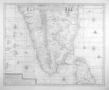 | Details | van Keulen, Gerard | 1728 |
| Nova Tabula Terrarum Cucan, Canara, Malabaria, Madura, Coromandelia |
|
van Keulen, Gerard |
|
| 1728 |
| LOC:0 |
| $0.00 | van-Keulen--Gerard | Nova-Tabula-Terrarum-Cucan--Canara--Malabaria--Madura--Coromandelia | SOLD<br></br>
Scarce Dutch chart of the Laccadive Islands, southern India, northern Sri Lanka (Ceylon) including the capital of Colombo. Based on the work of Adriaan Reland (Reelant) (1676-1718), a Dutch scholar and cartographer. The chart is decorated with numerous vignettes of sailing vessels and five compass roses.
<br></br>
Published by Gerard van Keulen in the fifth part of the sea-atlas "Zee-Fakkel" or Sea Torch which was issued by the House of Keulen in various editions from 1678 - 1753. According to C. Koeman this specific chart first appeared in the 1728 edition of the Zee-Fakkel. |
| 5462 | 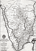 | Details | Anville, Jean Baptiste Bourguignon d' | 1737 |
| Original antique map of southern India and Coromandel Coast after Bouchet |
|
Anville, Jean Baptiste Bourguignon d' |
|
| 1737 |
| LOC: |
| $450.00 | Anville--Jean-Baptiste-Bourguignon-d- | Original-antique-map-of-southern-India-and-Coromandel-Coast-after-Bouchet | Early antique copper-plate engraved map from 1737 of <strong>southern India</strong> and a bit of Sri Lanka (Ceylan) including the <strong>Coromandel Coast</strong> of southeast India.
<br></br>
Created by J.B. d'Anville (1697-1782) after Jesuit cartographer Jean-Venant Bouchet who spent 30 years surveying southern India. Includes the Jesuit "logo" at bottom left, an acknowledgement of its Jesuit sources. Anville would have used the symbol to legitimize and to promote the value of this derivative work.
<br></br>
Engraved by Louis Corne. Apparently scarce. No copy found for sale online nor any sale record in AMPR.
<br></br>
This is one of the earliest maps to accurately detail the interior of Southern India. Legend at lower left identifies locations described in French as:
<div class="indenttextblocksingle">
<ul style="list-style-type: circle;">
<li>Place considerable</li>
<li>Demeure d'un Nabab ou Gouvereur.</li>
<li>Demure d'un Paleagaren ou petit Prince.</li>
<li>Eglise ou Christienti.</li>
<li>Pagode ou Temple de Gentile.</li>
</ul>
</div> |
| 4702 |  | Details | Bellin, Jacques Nicolas | 1750 |
| Antique plan of Diu Island, India |
|
Bellin, Jacques Nicolas |
|
| 1750 |
| LOC:13 |
| $155.00 | Bellin--Jacques-Nicolas | Antique-plan-of-Diu-Island--India | Antique plan of Diu Island and the Portuguese fortress at Diu, in Gujarat province, India. Includes St. Paul church, a mosque, and several defensive positions.
<br></br>
Shows the port and fortification of Diu once called the "Gibraltar of the East', with the hospital, the church of St. Paul and St. Jago. The fortification was the site of the Battle of Diu in 1509 between Portugal and a fleet of ships of the Ottoman, Egyptian, Venetian, allies of the Sultan of Gujarat, Mahmud Begada. Diu remained in possession of the Portuguese from 1535 until 1961, when it fell to troops of the Indian Union.
<br></br>
Re-engraved by von Schley after a French view by J.N. Bellin and published in Amsterdam in a Dutch edition of L'Histoire Generale des Voyages. Verso is blank. |
| 4857 | 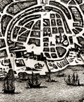 | Details | Bellin, Jacques Nicolas | 1750 |
| Antique engraved plan of Goa, India |
|
Bellin, Jacques Nicolas |
|
| 1750 |
| LOC:13 |
| $325.00 | Bellin--Jacques-Nicolas | Antique-engraved-plan-of-Goa--India | Fine mid eighteenth-century birds-eye view map (plan) of Goa and the Port of Goa, on the southwest coast of India, under Portuguese rule from 1510 to 1961. If you look carefully on the beach you can see two elephants, apparently used for heavy work at the docks and shipyard. A fine legend at right, in an elaborate title cartouche, names twenty-nine locations on the plan.
<br></br>
A fine view of Goa as it existed in 1607 by the prolific desk-cartographer J.N. Bellin. The plan is from the 1607 voyage of Admiral Paulus van Caerden, with the Dutch East India Company (VOC). From Prevost's 'Collection of Voyages'.
<br></br>
North is oriented to the bottom. Tome VIII No IX.
<br></br>
French hydrographer Jacques Nicolas Bellin (1703-1772) was born in Paris and educated as an engineer. In 1741, Bellin became the first Ingénieur de la Marine of the Depot des cartes et plans de la Marine (the French Hydrographical Office) and was named Official Hydrographer of the French King. Bellin's largest and most comprehensive work is the "Petit Atlas Maritime Recueil De Cartes et Plans Des Quatre Parties Du Monde Petit Atlas Maritime". |
| 4701 | 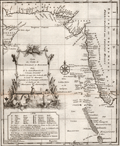 | Details | Bellin, Jacques Nicolas | 1750 |
| Antique map with Iran, India, and Yemen |
|
Bellin, Jacques Nicolas |
|
| 1750 |
| LOC:13 |
| $180.00 | Bellin--Jacques-Nicolas | Antique-map-with-Iran--India--and-Yemen | Attractive and highly decorative antique map of the Malabar coast of India, the Arabian Sea, and the coasts of Yemen, Iran, and Pakistan. Includes a good depiction of the Maldive Islands and the Laccadive Islands. Numerous noted locations include Surat, Bombay (Mumbai), Rajapor, Goa, Kalikoet (Calicut, now Kozhikode), Madura, and Cape Comorin.
<br></br>
Graphic title cartouche features a seahorse and a merman, with dragonfly-winged heads above. Legend at bottom left contains Dutch translations of many French geographical terms.
<br></br>
Re-engraved by von Schley after a French map by J.N. Bellin and published in Amsterdam in a Dutch edition of L'Histoire Generale des Voyages. Dutch title at bottom reads "Kaart van de Kusten van Persie, Guzaratte en Malabar…" |
| 1065 | 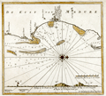 | Details | van Keulen, Johannes | 1753 |
| Scarce Dutch Chart of Kayalpatnam, India |
|
van Keulen, Johannes |
|
| 1753 |
| LOC:6 |
| $350.00 | van-Keulen--Johannes | Scarce-Dutch-Chart-of-Kayalpatnam--India | Scarce antique "secret" coastal chart of "Cayl" ( Kayalpatnam ) on the Gulf of Mannar, near the southern end of the Coromandel Coast (Tamil Nadu) that had long been prosperous from maritime trade and pearl fishing. The area was conquered by the Portuguese in 1548, and taken over by the VOC in 1658. Prior to that time Kayal is referred to in Marco Polo's travel diaries dating to 1250 AD. Kayal was an important trading port dating to the 1st century A.D.
<br></br>
The chart identifies Dutch settlements / churches in the area of <b>Kayalpatnam</b>: Warande Patnam, Ould Cayl, Tolhuys, and Groote Kerk van Pt. Cayl, several topped by the Dutch flag. Insert elevation view facing west of the coast line. The seas feature detailed nautical information, including bathymetric soundings and the locations of sandbars and other navigation hazards.
<br></br>
From the sixth part of van Keuelen's "<b>de Nieuwe Groote Lichtende Zee-Fakkel</b>" based on secret charts of the <b>Dutch East India Company</b> (Vereenigde Oost-Indische Compagnie or <b>VOC</b>). Prior to the mid-18th century these charts were only disseminated in manuscript to safeguard what the VOC considerd to be proprietary trade secrets. The Dutch East India Company was the dominant trade force in Asia for nearly 200 years.
<br></br>
Bears the attribution at bottom: "In't ligt gebragt door Joannes van Keulen". |
| 1086 |  | Details | van Keulen, Johannes | 1753 |
| Scarce Dutch Chart of Tuticorin, India |
|
van Keulen, Johannes |
|
| 1753 |
| LOC:6 |
| $350.00 | van-Keulen--Johannes | Scarce-Dutch-Chart-of-Tuticorin--India | Scarce Dutch Chart of Tuticorin, India on the Gulf of Mannar, India by Johannes van Keulen from 1753. |
| 1173 | 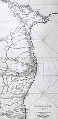 | Details | Anville, Jean Baptiste Bourguignon d' | 1753 |
| Antique Chart of The Coromandel Coast of India |
|
Anville, Jean Baptiste Bourguignon d' |
|
| 1753 |
| LOC:0 |
| $300.00 | Anville--Jean-Baptiste-Bourguignon-d- | Antique-Chart-of-The-Coromandel-Coast-of-India | Fine large antique French sea chart of India's Coromandel coast, the southeastern coastal region of the Indian Subcontinent, between the Eastern Ghats and the Bay of Bengal of the Indian Ocean. |
| 1210 | 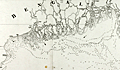 | Details | Dalrymple, Alexander | 1772 |
| Chart of the Northern Part of The Bay of Bengal |
|
Dalrymple, Alexander |
|
| 1772 |
| LOC:59 |
| $950.00 | Dalrymple--Alexander | Chart-of-the-Northern-Part-of-The-Bay-of-Bengal | Rare English sea chart, covering the mouth of the Ganges River and surrounding areas, by Alexander Dalrymple. Includes the population centers of Kolkata ("Calcutta") and Chittagong ("Islamabad") and the Chittagong Coast.
<br></br>
List of references at upper right of the chart contains a listing of islands, rivers, and creeks between Sagor and Chittagong.
<br></br>
Includes very extensive depth extensive soundings in fathoms. Arrows indicate the directions of strongest part of the flood-tide; Roman numbers show the high and low tides.
<br></br>
Published by Alexander Dalrymple on 15 September, 1772 "According to an Act of Parliament." In his doctoral thesis Cook wrote of Dalrymple that he was: <div class="indenttextblock"> "now generally regarded as the originator of official British hydrography… was cumulatively a private publisher of nautical charts and plans (from 1767), the 'examiner of ships' journals' and chart publisher for the East India Company (from 1779), and Hydrographer to the Admiralty (from 1795)". </div>
<br>
<div class="indenttextblock">Reference: Cook, Andrew S., <b>Alexander Dalrymple (1737 - 1808) Hydrographer to the East India Company and to the Admiralty; as publisher: A Catalogue of Books and Charts. </b> Vol. 3 .Doctoral Thesis, University of St. Andrews. 1992.</div> |
| 5207 |  | Details | Mannevillette, d'Apres | 1775 |
| Nautical chart of the Nicobar Islands Indian Ocean |
|
Mannevillette, d'Apres |
|
| 1775 |
| LOC:9 |
| $300.00 | Mannevillette--d-Apres | Nautical-chart-of-the-Nicobar-Islands-Indian-Ocean | Original engraved sea chart of the Nicobar Island Archipelago in the Bay of Bengal. Islands in the Nicobar Archipelago include Car Nicobar, Battimalym, Chowra, Great Nicobar, Little Nicobar, Katchal, Nancowry, and more. In 2013 UNESCO declared 85% of Great Nicobar Island, the largest, as the Great Nicobar Biosphere Reserve.
<br></br>
Manvillette's chart Includes an inset plan of the channel between the islands of Camorta, Nancowry, and Trincut which would have provided a harbor from storms but where navigation without the chart would have been dangerous: "Plan Particulier du Port Compris entre les Isles Nancaueri, Souri, et Tricutte."
<br></br>
This fine hand-colored nautical chart is from J. B. d'Apres de Mannevillette's sea atlas "Le Neptune Oriental ou routier general des Cotes des Indes orientales et de la Chine." Jean-Baptiste d'Après de Mannevillette (1707 - 1780) was a French sailor, navigator, and hydrographer active in the mid-18th century. Mannevillette studied mathematics and navigation in Paris before winning a commission as an officer on a merchant vessel headed for the West Indies. Mannevillette collected and revised a number of regional nautical charts during numerous voyages around Africa to India and China. |
| 7887 | 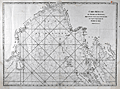 | Details | Mannevillette, d'Apres | 1775 |
| Malacca Strait Bay of Bengal, from the Isle of Ceylon Gulf of Siam |
|
Mannevillette, d'Apres |
|
| 1775 |
| LOC:141 |
| $495.00 | Mannevillette--d-Apres | Malacca-Strait-Bay-of-Bengal--from-the-Isle-of-Ceylon-Gulf-of-Siam | A fine 18th-century nautical chart of the Bay of Bengal ."Carte Reduite du Golfe de Bengale, depuis L'Isle De Ceylan jusqu'au Golfe De Siam, avec la partie Septentrionale du Detroit De Malac". Produced by Jean-Baptiste Nicolas Denis d'Après de Mannevillette (1707-1780).
<br><br>
It depicts the Bay of Bengal region, extending from Ceylon (present-day Sri Lanka) to the Gulf of Siam (now known as the Gulf of Thailand), and include the northern part of the Strait of Malacca.
<br><br>
<div style="text-align: center;font-size:105%;">
<i>Professional hand coloring for this chart is available at a very modest fee.</i>
</div> |
| 421 | 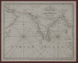 | Details | Malham, John | 1797 |
| A Correct Chart of the Indian Ocean engraved for Malham's Naval Gazetteer |
|
Malham, John |
|
| 1797 |
| LOC:200 |
| $175.00 | Malham--John | A-Correct-Chart-of-the-Indian-Ocean-engraved-for-Malham-s-Naval-Gazetteer | Scarce chart showing the Indian Ocean, Arabian Sea and Bay of Bengal. From the first American edition of Malham's Naval Gazetteer, published by Spotswood and Nancrede in Boston during September 1796. Vol 2.<BR> </BR>
This chart comes from an early nautical gazetteer produced first in England and after 1796 in Boston, Massachusetts. Coverage includes the Persian Gulf, Maldive Islands, Andaman Island, and Nicobar Islands. With three sets of rhumb lines. Rev. John Malham was a prolific Yorkshire-born author. Malham died near London in 1807. Archivally matted.<BR> </BR> |
| 3636 | 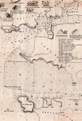 | Details | Anonymous | 1844 |
| Rare antique chart of the Port of Goa and Mormugao, India |
|
Anonymous |
|
| 1844 |
| LOC:0 |
| $0.00 | Anonymous | Rare-antique-chart-of-the-Port-of-Goa-and-Mormugao--India | SOLD<br></br>
Scarce Portuguese chart of the Port of Goa, on the southwest coast of India. which was under Portuguese rule from 1510 to 1961. By Antonio Lopes da Costa Almeida (1784-1859), barão de Reboredo. Among his many credits Antonio da Costa Almeida was associated with the Academy of Guardas-Marinhas and the Naval Artillery.
<br></br>
The most interesting portion on this lithographed antique chart are the eight charming and naïve elevation views placed at the top of the print. These views include: Vistas das casas das Freiras, Vistas das casas de D. Joanna, and Vista das cruz du Betim.
<br></br>
Our chart, "Carta Hydrographica do Porto de Goa e Entrada das Barras de Agoada de Mormugao", was printed in 1844 just one year after the Portuguese moved the capital to Panaji from Velha Goa. By the mid-18th century, Portuguese Goa had expanded to most of the present-day state limits.
<br></br>
Key topographic features on the chart include Panaji, the Mandovi River, Zauri River, Provincia de Salcette, and Provincia de Bardez. Seventeen important locations on the map are identified alphabetically on the chart and are explained in a legend at right.
<br></br>
Our chart of Goa accompanied the work: "Esclarecimentos Hydrographicos para intelligencia e uso do Plano dos Portos de Goa e Mormogao" in Annaes Maritimos e Colonias. Quinta Serie. No 7, 1844, Lisboa. Lithographed in 1844 by A.C. Lemos, Largo do Quintella no. 1. Lisbon. |
| 833 |  | Details | James Imray and Son | 1868 |
| West Coast of India from Kanyakumari (Cape Comorin) to Mumbai (Bombay) |
|
James Imray and Son |
|
| 1868 |
| LOC:0 |
| $600.00 | James-Imray-and-Son | West-Coast-of-India-from--Kanyakumari-(Cape-Comorin)-to-Mumbai-(Bombay) | Scarce antique blueback nautical chart of the West coast of India, including Mumbai ( Bombay ) and Goa, trending southward to Kanyakumari ( Cape Comorin ). Cape Comorin is the southern-most point of the Indian subcontinent, surrounded by the Laccadive Sea. This scarce nineteenth-century blueback nautical chart contains detailed inset port plans of Cochin Harbor, Calicut Roads, Bombay Harbor, and the Approach to Bombay.
<br></br>
During the 1800's there was a trend toward publication of very large small-scale charts with large-scale insets of key passages and harbors. The practice was adopted as much for economics as any other reason. James Imray and Son was one of a handful of British publishers who specialized in these charts which were often backed with canvas or linen cloth or heavy blue paper in order to help them withstand the frequent use and abuse aboard ship, hence the term "blueback chart".
<br></br>Due to changing conditions charts could become outdated quickly and it was important for mariners to understand the accuracy of their navigational charts. The British Admiralty and later the U.S. Coast Survey responded by recording the dates of each update on the map, in some cases maintaining a historical record of updates spanning many decades. Private publishers of sea charts like Imray or Laurie fulfilled the same need by providing the date of the last update with an inked overstamp. On this chart we find an example of that practice, an oval-shaped blue ink over-stamp that reads: "Imray and Son 1869".
<br></br>
Published by James Imray and Son, 89 and 102 Minories. Laid to blue paper for protection with cloth selvage. Original cloth map ties. Yellow label from the Imray firm attached on verso that reads "James Imray and Son, Hydrographers.". James Imray and Son is one of the three firms that over the last two centuries combined to form Imray Laurie Norie & Wilson Ltd. |
| 837 |  | Details | James Imray and Son | 1872 |
| Bay of Bengal with The Andaman and Nicobar Islands |
|
James Imray and Son |
|
| 1872 |
| LOC:0 |
| $0.00 | James-Imray-and-Son | Bay-of-Bengal-with-The-Andaman-and-Nicobar-Islands | SOLD<b></b>
Antique blueback nautical chart of the Eastern part of the Bay of Bengal. Includes the Myanmar ( Burma ) coast; a portion of the Thailand coast including Phuket; the Northwest coast of Sumatra including Banda Aceh; and the Andaman and Nicobar Islands, a territory of India. Ten inset charts of: Port Cornwallis, St. Georges Channel, Pulu Milu, Galatea Bay, Port Campbell, the Rangoon River, Amherst Road, Port Blair, Penang, and Nangcovri Harbor.
<br></br>
Chart includes North Sentinel Island off the West coast of South Andaman Island. That island is home to the Sentinelese people, one of the last paleolithic ( early stone age) tribes, of between 50 and 400 persons. The Sentinelese fiercely resist contact with the outside world and are reported to have survived the 2004 Tsunami by moving to higher ground in advance, almost as though they knew what to expect.. In 2006 the Sentinelese are reported to have fired arrows at two fishermen, killing them after they were wrecked on the island.
<br></br>
During the 1800's there was a trend toward publication of very large small-scale charts with large-scale insets of key passages and harbors. The practice was adopted as much for economics as any other reason. James Imray and Son was one of a handful of British publishers who specialized in these charts which were often backed with canvas or linen cloth or heavy blue paper in order to help them withstand the frequent use and abuse aboard ship, hence the term "blueback chart".
<br></br>
With an oval-shaped blue ink over-stamp that reads: "Imray and Son 1872 London".
<br></br>
Published by James Imray and Son, 89 Minories and Tower Hill 1870. Laid to blue paper for protection. Yellow label from the Imray firm attached on verso that reads "James Imray and Son, Hydrographers." |
| 5335 |  | Details | British Admiralty Hydrographical Office | 1886 |
| Antique British Chart Port of Bombay India |
|
British Admiralty Hydrographical Office |
|
| 1886 |
| LOC:9 |
| $1,650.00 | British-Admiralty-Hydrographical-Office | Antique-British-Chart-Port-of-Bombay-India | Rare antique British harbor chart of the port of Bombay (Mumbai), India by the British Admiralty Hydrographical Office. This fine engraved chart covers the Port of Bombay on the east side of the southern peninsula from Prince's Dock (built in 1885) at the north down just past Sassoon Dock in the south.
<br></br>
At left of the chart is a table of data about the wet docks and graving docks including the width of the entrance and the depth over the sill. Six informative profile views of local aids-to-navigation include :
<div class="indenttextblocksingle">
<ul style="list-style-type: circle;">
<li>The Malet Shelf Beacon</li>
<li>North Channel Beacon</li>
<li>South Channel Beacon</li>
<li>North Kolaba (Colaba) Beacon</li>
<li>South Kolaba (Colaba) Beacon</li>
<li>Sunk Rock Lighthouse</li>
</ul>
</div>
Some of the key features and locations noted at the Port of Bombay are:
<div class="indenttextblocksingle">
<ul style="list-style-type: circle;">
<li>Great Indian Peninsula Railway lines and yard</li>
<li>Bombay, Baroda & Central India rail lines and Kolaba RY station</li>
<li>The dockyard</li>
<li>Sailor's home</li>
<li>Church Gate RY station</li>
<li>Fort district</li>
<li>Castle [Castle da Orta]</li>
<li>Ice house</li>
<li>Carnac, Nicol, and Musjid basins</li>
<li>The Pilot Pier</li>
</ul>
</div>
Published at the Admiralty 14th January 1885 under the Superintendence of Captain W. J. L. Wharton, R.N. Hydrographer. Number 655. Sold by J. D. Potter, London. Last corrections in 1886. Engraved by Davies and Company. |
| 5187 |  | Details | British Admiralty Hydrographical Office | 1895 |
| Atlas of 12 monthly current charts Indian Ocean 1895 |
|
British Admiralty Hydrographical Office |
|
| 1895 |
| LOC:0 |
| $0.00 | British-Admiralty-Hydrographical-Office | Atlas-of-12-monthly-current-charts-Indian-Ocean-1895 | SOLD<br></br>
Rare hydrographic atlas published by the British Admiralty with twelve charts (January-December) of the Indian Ocean showing the prevailing current direction and velocity for each month. The charts were all based on data collected as far back as 1830. Each chart was published at different dates in 1895 and 1896 under the Superintendence of Admiral Wharton, Hydrographer. Price when issued was ten shillings. |
| 5364 |  | Details | Anonymous | 1909 |
| Pair of manuscript allegorical Maps of the Heart, anatomically correct. |
|
Anonymous |
|
| 1909 |
| LOC:13 |
| $1,100.00 | Anonymous | Pair-of-manuscript-allegorical-Maps-of-the-Heart--anatomically-correct- | Two rare <b>manuscript pen and ink</b> anatomically-correct heart-shaped geographical guides or allegorical maps: "Map of Man's Heart" and "Map of Woman's Heart". Both maps are attributed within circular cartouches reading "Surveyed and Drawn by HUB. Scale 2 miles = 1". 1909." This style of anatomical heart-shaped maps and some of the traits are not found anywhere online.
<br></br>
After similar Victorian-era maps by D.W. Kellogg & Co. of Connecticut ca. 1840. Unlike this manuscript pair of maps, the Kellogg lithographs were based on a stylized and exaggerated bi-lobed conception of the heart- the "Valentine" heart that we know today. Despite the differences in wording of traits, the theme of negative stereotypes for women is the same.
<br></br>
Map of Man's Heart includes large areas devoted to patience, modesty, fidelity (twice), benevolence, humanity, knowledge and love. On the other hand, the Map of Woman's Heart largely features conceit, jealousy, scandal, duplicity, deceit, fickleness and avarice among other traits. The woman's heart is pierced by the "River Tongue" and surrounded on one side by the "kleptomaniac ocean" and on the other side, the "cantankerous ocean".
<br></br>
Seller attributes the provenance to India "it came from a nurses friendship book, she being based in Bangalore India - her name was probably MacDonald." |
| 6621 |  | Details | Sundberg, Edwin L. | 1946 |
| India Britains Problem Child Pictorial Coloroto map |
|
Sundberg, Edwin L. |
|
| 1946 |
| LOC:300 |
| $250.00 | Sundberg--Edwin-L- | India-Britains-Problem-Child-Pictorial-Coloroto-map | Post-WWII pictorial Coloroto (1) or color rotogravure map with India referred to a "Britain's Problem Child", reflecting Britain's colonial presence in India in July, 1946. A legend lists numerous exported products with icons for each including jute, coconut, manganese, copper, linseed, and rubber. Inset map at left shows trade routes from Britain to India via the Suez Canal with British colonies colored in red. Inset pictorial bar chart at right shows the comparative population for each religion in India.
<br><br>
(1) Coloroto is a trade name for a rotogravure used to print multiple colors. According to Google a rotogravure printing system uses a rotary press with <b>intaglio cylinders</b>, typically running at high speed and used for long print runs of magazines and stamps. (Google Oxford languages dictionary. Online).
<br><br> |