| | Thumbnail | | Creator | Date | Title / Author / Date / Location | Price | | | Description |
| 6616 | 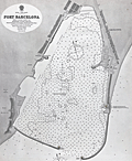 | Details | British Admiralty Hydrographical Office | |
| Original Admiralty harbor chart for Port Barcelona |
|
British Admiralty Hydrographical Office |
|
|
| LOC:57 |
| $900.00 | British-Admiralty-Hydrographical-Office | Original-Admiralty-harbor-chart-for-Port-Barcelona | Original 1873 British Admiralty harbor chart of the Port of Barcelona, Spain, issued as chart no. 1195. Published at the Admiralty in London under the superintendence of Rear Admiral G. H. Richards, Hydrographer, and based on Spanish surveys conducted in 1871. The chart was engraved by Edward Weller and drawn by H. Stafford. As with other Admiralty productions of the period, it reflects standardized hydrographic practices intended for practical navigation rather than decorative presentation.<br><br>
The chart details the harbor and immediate coastal approaches with extensive soundings, shoreline configuration, and port infrastructure as they existed in the early 1870s. Labeled features include Montjuich, the Arsenal, Punta de la Paz, Vista Alegro, Huertas de S. Beltran, and Barceloneta. Harbor works and alterations are shown, including the Old Mole light, noted as scheduled for demolition, documenting changes underway in the port’s configuration. The sheet captures Barcelona at a moment of transition, as the harbor was being adapted to accommodate increased commercial and industrial maritime traffic.<br><br>
British Admiralty charts were produced for active use by naval and commercial mariners and were regularly updated as surveys improved. As a result, early impressions such as this example are increasingly scarce in original form. This chart is of interest for its documentation of 19th century harbor engineering, Mediterranean navigation, and the development of Barcelona as a major port city, and it fits well within collections focused on nautical cartography, port plans, or European maritime history. |
| 924 |  | Details | Bordone, Benedetto | 1534 |
| Very early map of the Leeward Islands of the Lesser Antilles |
|
Bordone, Benedetto |
|
| 1534 |
| LOC:5 |
| $940.00 | Bordone--Benedetto | Very-early-map-of-the-Leeward-Islands-of-the-Lesser-Antilles | The first printed maps of the Caribbean islands of St. Martin and Guadeloupe, published just 42 years after Christopher Columbus first landed in the New World. An attractive group of three antique maps inset on a single sheet with Italian text on verso and recto.
<br></br>
The recto includes a small-scale chart of the Leeward Islands. Here the geographical relationship of the islands bears little resemblance to present-day maps. Bordonne names the islands: "S. Maria Rotonda"; "Moserato" or Montserrat; "Buchima" or "Barbuda"; "Dominica"; S. Maria Antica" or Antigua; "Santa" or "Saint Kitts?; and "C. Martino" or St. Martin.
<br></br>
Two additional maps on the verso show the islands of "Guadalupe" Guadeloupe and "Matinina" or St. Martin. Each island is decorated with features that Bordonne addresses in the text. Guadeloupe is shown covered with a low leafy vegetation. St. Martin sports numerous caves set into small hills.
<br></br>
Published from Venice in 1534 in the second edition of Benedetto di Bordone's "Isolario", or Island Book. The Isolario provided nautical-chart inspired maps of islands alongside information for travellers on their culture, myths, climate, and history.
<br></br>
Bordone (1460-1531) was a Paduan cartographer, and an illustrator of manuscripts, best known for his 'Isolario' or book of islands. Bordone's work was only the second isolario ever printed, the first being that of Bartolommeo Dalli Sonneti published in 1485. Text in Italian. |
| 927 |  | Details | Bordone, Benedetto | 1534 |
| Early map of the Canary Islands and Cape Verde Islands |
|
Bordone, Benedetto |
|
| 1534 |
| LOC:7 |
| $950.00 | Bordone--Benedetto | Early-map-of-the-Canary-Islands-and-Cape-Verde-Islands | The first small-scale printed map to name the individual <b>Canary Islands</b> now part of Spain, and the Portugese <b>Cape Verde Islands</b>. Both groups of islands are shown in the Atlantic Ocean on a single map with part of Africa.
<br></br>
At right Bordonne shows the coast of Africa and names the on-shore regions "Getulia", "Argin" (Arguin ?), and "Libya di Sotto". Bordonne's names for the main Canary Islands and their modern equivalents are: "Palma" (La Palma), "Agore" (La Gomera), "Tinerif" (Tenerife), "Canaria" (Gran Canaria), "Forte Ventura" (Fuerteventura), and "Lazazoto" (Lazarote).
<br></br>
At bottom left are the most northern of the Cape Verde Islands, or the Ilhas de Barlavento:
"S. Antonio" ( Santo Antão),"S. Vincenzio" (São Vicente), "S. Jacopo" ("Santa Luzia"), "S. Nicolo" (São Nicolau). Some islands shown close to the coast are more difficult to account for: "I. Bianca" (Sal ?), "I. delle Gaze" (Boa Vista ?) and "Cuori".
<br></br>
From the second Zoppino edition of Benedetto di Bordone's "<b>Isolario di Benedetto Bordone</b> Nel qual si ragiona di tutte l'Isole del mondo, con li lor nomi antichi & moderni, historie, favole, & modi del loro vivere, & in qual parte del mare stanno, & in qual parallelo & clima giaciono. Con la gionta del Monte del Oro novamente ritrovato". This scarce antique map was published from Venice in 1534, just 42 years after Christopher Columbus first landed in the New World. The Isolario provided nautical-chart inspired maps of islands alongside information for travellers on their culture, myths, climate, and history.
<br></br>
Bordone (1460-1531) was a Paduan cartographer, and an illustrator of manuscripts, best known for his 'Isolario' or book of islands. Bordone's work was only the second isolario ever printed, the first being that of Bartolommeo Dalli Sonneti published in 1485. Text on verso in Italian. |
| 906 |  | Details | Bordone, Benedetto | 1534 |
| Very early Balearic Island charts with Ibiza and Majorca |
|
Bordone, Benedetto |
|
| 1534 |
| LOC:4 |
| $1,250.00 | Bordone--Benedetto | Very-early-Balearic-Island-charts-with-Ibiza-and-Majorca | Two of the earliest obtainable maps of Spain's Balearic Islands: Majorca / Mallorca, Minorca / Menorca, Ibiza / Eivissa, and Formentera. A single sheet containing two antique woodcut maps (one map on each side). Published from Venice in 1534 in the second edition of Benedetto di Bordone's 'Isolario', or "Island Book". The Isolario provided nautical-chart inspired maps of islands alongside information for travellers on their culture, myths, climate, and history.
<br></br>
Recto contains a map with a portion of the eastern coast of Spain, at that time part of the "Regno de Catelogna", with five un-named settlements near "C. Martino" (today a diving spot kown as Cabo de San Martin) that may include Gandia, Javea / Xàbia, or Alicante. Offshore of the coast are the Balearic islands of Ibiza ("Ieuiza") and Formentera ("Formentazia") with the smaller surrounding islets of Tagomago, "Famolaria" (Santa Eulalia ?), and "Dragoneza" in the vicinity of Illa Sa Conillera. The last may be a error on the part of Bordone as there is an island "Illa Sa Dragonera" but it is located off the coast of Mallorca in roughly the same relative location to the west of the island.
<br></br>
Verso contains a map with Majorca ("Maiorica") with "Porto Colobo" or the Bay of Palma, and Minorca ("Minorica") with " Porto Mao" or Port Mahon. Two islets shown are Illa de l'Aire ("Cabrera") and "Dragonera".
<br></br>
Bordone's directional symbols correspond to many of the Italian names for the principal Mediterranean winds including, [G]reco; a cross denoting East ; [S]irocco; [O]stro or South; [P]onente or West; and [M]aestro.
<br></br>
Bordone (1460-1531) was a Paduan cartographer, and an illustrator of manuscripts, best known for his 'Isolario' or book of islands. Bordone's work was only the second isolario ever printed, the first being that of Bartolommeo Dalli Sonneti published in 1485. Text in Italian. |
| 4732 | 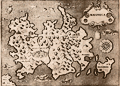 | Details | Porcacchi, Tomasso | 1572 |
| Very old antique map of Mallorca, Spain |
|
Porcacchi, Tomasso |
|
| 1572 |
| LOC:4 |
| $0.00 | Porcacchi--Tomasso | Very-old-antique-map-of-Mallorca--Spain | SOLD
<br></br>Authentic copperplate-engraved antique map (1572) of Maiorica (Mallorca, Majorca), Spain engraved by Girolamo Porro and drawn by Tomasso Porcacchi. Liberal usage of stippling in the seas.
<br></br>
Around the Balearic Island known for its beach resorts numerous fantastical sea serpents and monstrous fishes fill empty areas in the finely stippled seas. A few of the key features in this small map of Mallorca include the much smaller island of Dragonera, Palomera, Cala figuera, Monacur, Cabo della Prea, and Premontor. Interior details include simple illustrations of trees, mountains, and villages.
<br></br>
Printed in Tomasso Porcacchi's "Isolario" or island book "L'Isol Piu Famose Del Mondo". That work contains a number of finely engraved maps of islands and the continents at a reduced scale. Porcacchi (1530-1585) was born in Tuscany to a poor family and first settled in Florence. He wrote about history, geography, and archaeology and later published the Isolario from Venice, Italy in three editions beginning in 1572. |
| 5196 | 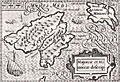 | Details | Bertius, Petrus | 1616 |
| Majorcae Et Minorcae Descrip |
|
Bertius, Petrus |
|
| 1616 |
| LOC:77 |
| $325.00 | Bertius--Petrus | Majorcae-Et-Minorcae-Descrip | Uncolored miniature antique map of the <b>Balearic Islands</b> (Baleares) of Majorca and Minorca, Spain in the Mediterranean Sea. Key named features include Porto Pin, Calafigur, Calalonga, Menacor, Cabo Formentelli, Porto Fornelle, and San Catharina. Sea monsters and a lateen-rigged sailing ship beautifully decorate the map while filling empty areas in the sea. In the crow's nest high above the deck a sailor is depicted throwing objects overboard, a detail perhaps related to a ritual of good fortune.
<br></br>
This fine copper-plate engraved map of Mallorca from a <b>French edition</b> of Petrus Bertius' <b>Tabularum Geographicarum Contractarum</b>. The basis of the "Tabularum" was the atlas Caert Thresoor by Barent Langenes, first published in 1598.
<br></br>
French text on verso.
<br></br>
[ Mallorca, Majorca, Majorcae, Minorca, Menorca, Minorcae ] |
| 4696 | 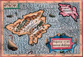 | Details | Bertius, Petrus | 1616 |
| Descriptio Maioricae et Minoricae |
|
Bertius, Petrus |
|
| 1616 |
| LOC:13 |
| $350.00 | Bertius--Petrus | Descriptio-Maioricae-et-Minoricae | Colorful miniature antique map of the <b>Balearic Islands</b> (Baleares) of Majorca and Minorca, Spain in the Mediterranean Sea. This lovely copper-plate engraved map is from a Latin edition of Petrus Bertius' <b>Tabularum Geographicarum Contractarum</b>. The basis of the "Tabularum" was the atlas Caert Thresoor by Barent Langenes, first published in 1598. Key named features include Porto Pin, Calafigur, Calalonga, Menacor, Cabo Formentelli, Porto Fornelle, and San Catharina.
<br></br>
Sea monsters and a lateen-rigged sailing ship beautifully decorate the map while filling empty areas in the sea. In the crow's nest high above the deck a sailor is depicted throwing objects overboard, a detail perhaps related to a ritual of good fortune.
<br></br>
Latin text on verso. |
| 21 |  | Details | Levanto, Francesco M. | 1664 |
| La Costa di SPAGNA |
|
Levanto, Francesco M. |
|
| 1664 |
| LOC:8 |
| $900.00 | Levanto--Francesco-M- | La-Costa-di-SPAGNA | Rare nautical chart of the Mediterranean coast of southern Spain including Alicante and Cartagena Spain and of the North African coastline including Oran and Cape Ferrat. Portolan-style central compass rose surrounded by a concentric grouping of rhumb lines. <BR> </BR>
Produced by the Genoan cartographer Francesco Maria Levanto in 1664 in "La Prima Parte dello Specchio del Mare…" (Sea Mirror) probably from earlier Dutch charts, possibly by Jacobsz. This antique sea chart was reissued later by Coronelli in 1697. Charts from Levanto's Specchio del Mare are quite scarce. Plate 5. Chain laid paper. |
| 368 |  | Details | Goos, Pieter | 1664 |
| Cuft van Hispagnien vande Rivier Sivilien |
|
Goos, Pieter |
|
| 1664 |
| LOC:8 |
| $1,450.00 | Goos--Pieter | Cuft-van-Hispagnien-vande-Rivier-Sivilien | Attractive and desirable small-scale antique nautical chart covers the Atlantic approaches to the Strait of Gibraltar with Cadiz, Spain, Algeciras ("Out Gibralter"), Sanlucar de Barrameda , Xeres, Rota, Cape Trafalgar, and the Guadalquivir River to just past the small stream of Brazo de la Torre. Inside the strait and in the Mediterranean are Tangier, Ceuta, Tetuan, and Penon de Velez on the north coast of Africa. On the south coast of Spain Gibraltar, Algeciras, Tarifa, Marbella, and Malaga are featured. <BR> </BR>
A fine antique chart of the historically important area surrounding the Strait of Gibraltar and Cadiz, Spain. With an elaborate strapwork cartouche, two compass roses, and depictions of a galley and a square-rigged sailing vessel, the two predominant sea-going vessels of that era. Produced by Dutch cartographer Pieter Goos in Amsterdam in 1664. North oriented to the right. Plate number 3. <BR> </BR> |
| 4698 | 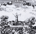 | Details | Pontault, Sébastien Beaulieu de | 1678 |
| Antique view of Montjuïc at Barcelona, Spain |
|
Pontault, Sébastien Beaulieu de |
|
| 1678 |
| LOC:13 |
| $225.00 | Pontault--Sébastien-Beaulieu-de | Antique-view-of-Montjuïc-at-Barcelona--Spain | Antique view of Montjuïc, a broad, low hill in Barcelona, Catalonia, Spain to the west of the old quarter. The top of Montjuïc (Castell de Montjuic) at about 550' is the site of several fortifications dating from the 17th century. These served as a prison, often holding political prisoners, until the time of General Franco.
<br></br>
Here, cannon are shown firing from the Castell while a marine semaphore atop a tall tower relays signals to nearby vessels. Montjuïc became a key element in the defence of Barcelona. By controlling the mountain and its communication with the rest of the city, the defenders of Barcelona could keep attacking troops further from the eastern perimeter of the city walls and the coastline.
<br></br>
This antique copper engraving is from <b>Pontault de Beaulieu's</b> "Plans et profils des villes des Pays-Bas, Lorraine, Alsace, Catalogne et Franche-Comté".
<br></br>
According to the Atlas de Barcelona
<div class="indenttextblock"> Beaulieu drew the part of the small fort built during the Reapers’ War – which he might have known – and hints at the citadel which should surround it, in what could be considered to be a “future project”. French interest in the strategic Catalonian capital meant that even Beaulieu drew what could be the defenses of Barcelona. The French National Library keeps an ink drawing that Beaulieu himself drew of the layout of Montjuïc castle with the same framing as the engraving. (http://www.atlesdebarcelona.cat/gravats/comments/38-beaulieu-sebastien-de-pontault-de/). </div> |
| 4699 | 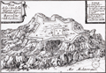 | Details | Pontault, Sébastien Beaulieu de | 1678 |
| Antique view of the citadel on Montjuïc at Barcelona, Spain |
|
Pontault, Sébastien Beaulieu de |
|
| 1678 |
| LOC:13 |
| $185.00 | Pontault--Sébastien-Beaulieu-de | Antique-view-of-the-citadel-on-Montjuïc-at-Barcelona--Spain | Antique view of the fort or citadel at Montjuïc, a broad, low hill in Barcelona, Catalonia, Spain to the west of the old quarter. The top of Montjuïc (Castell de Montjuic) at about 550' is the site of several fortifications dating from the 17th century. The steep and rocky sides of Montjuic are apparent where the land meets the Mediterranean Sea.
<br></br>
In a key to the upper right, five important entrances and fortifications at the citadel are identified.
<br></br>
According to the Atlas de Barcelona
<div class="indenttextblock"> Beaulieu drew the part of the small fort built during the Reapers’ War – which he might have known – and hints at the citadel which should surround it, in what could be considered to be a “future project”. French interest in the strategic Catalonian capital meant that even Beaulieu drew what could be the defenses of Barcelona. The French National Library keeps an ink drawing that Beaulieu himself drew of the layout of Montjuïc castle with the same framing as the engraving. (http://www.atlesdebarcelona.cat/gravats/comments/38-beaulieu-sebastien-de-pontault-de/). </div> |
| 1356 | 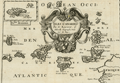 | Details | Sanson, Nicolas | 1680 |
| Fine antique map of the Canary Islands and Madeira ca. 1680 |
|
Sanson, Nicolas |
|
| 1680 |
| LOC:7 |
| $325.00 | Sanson--Nicolas | Fine-antique-map-of-the-Canary-Islands-and-Madeira-ca--1680 | Very attractive early map of the <b>Canary Islands by Nicolas Sanson</b>. Inset map of Madeira ("Isle Madere"). This fine copper-plate engraved map is dominated by a large scroll-work title cartouche, which is decorated with an elaborate garland of fruit. Nice details of towns and geography for each island.
<br></br>
Nicolas Sanson (1600 – 1667) was a French cartographer, termed by some as the "father of French cartography". Nicholas Sanson was born in the town of Abbeville in Picardy. He became become Royal Geographer to Louis XIII in 1630 and maintained the position upon the ascension of the "Sun King" Louis XIV in 1643. Sanson later served as tutor to the ambitious young monarch. From 1648 Nicolas Sanson produced a series of four quarto atlases on the continents. That atlas of Africa was first published in 1656 and included this map.
<br></br>
The Canary Islands are a Spanish archipelago that lies off the coast of northwestern Africa. Sanson's names for the main Canary Islands and their modern equivalents are: "Isle de Palme" (La Palma), "Isle de Gomer" (La Gomera), "Isle Teneriffe" (Tenerife), "Isle Canarie" or "Grande Canarie" (Gran Canaria), "Isle de Forte" (Fuerteventura), and "Isle de Lancelotte" (Lazarote). |
| 695 | 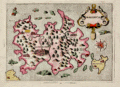 | Details | Porcacchi, Tomasso | 1686 |
| Antique map of Majorca, Balearic Islands, Spain |
|
Porcacchi, Tomasso |
|
| 1686 |
| LOC:4 |
| $325.00 | Porcacchi--Tomasso | Antique-map-of-Majorca--Balearic-Islands--Spain | Numerous fantastical sea monsters fill the empty spaces on this antique copperplate-engraved map of Majorca ( Mallorca ) , Spain the largest of the Balearic Islands. Majorca is nearly five times the size of its sister island Menorca. Majorca's history is closely tied to seafaring- the first people to colonize the island are believed to be Phoenician traders who arrived around the 8th century B.C.
<br></br>
This decorative old map was printed in 1686 in one of the last editions of Tomasso Porcacchi's "Isolario" or island book "L'Isol Piu Famose Del Mondo". This 1686 edition is differentiated from earlier versions in that: 1) it is the only edition where the maps are not set within printed text, and 2) the chart was re-engraved for this edition and the compass rose is less elaborate.
<br></br>On the compass rose Porcacchi identifies eight points that correspond to the classical eight-point naming convention for Mediterranean winds that dates back at least 2000 years. The octagonal "Tower of the Winds" of the Roman Agora in Athens, Greece contains friezes on each wall depicting the principal wind deities and was once capped with a weathervane. Porcacchi's compass rose symbols: "T", "G", "+" , "S", "O", "L", "P", "M", correspond to the Italian names for the principal Mediterranean winds: Tramontana ( North ), Greco, Levante ( with a cross denoting East ), Sirocco, Ostro ( South ), Libeccio. Ponente ( West ), and Maestro. ( Taylor, E.G.R., "The Haven Finding Art: A History of Navigation from Odysseus to Captain Cook". New York. 1957 (pp. 6-8)
<br></br>
Scrollwork title cartouche labeled simply: "Maiorica". Noted points of interest include islands of Cabrera and Dragonara, along with the Majorcan headlands of Capo Salime, P. Colombo, Monacur, Capo della Prea, Capo Formentar, Capo Baiol. Noted habitations include Maiorica ( Palma ), Cala Figera, Aliendia, Soller, Palomera, and Prementor.
<br></br>
Ample margins. Later attractive hand-coloring. |
| 998 | 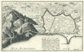 | Details | de Fer, Nicolas | 1693 |
| Old plan of Barcelona, Spain |
|
de Fer, Nicolas |
|
| 1693 |
| LOC:4 |
| $495.00 | de-Fer--Nicolas | Old-plan-of-Barcelona--Spain | Attractive, detailed antique birds-eye view or plan of Barcelona, Spain on the Mediterranean Sea, from 1693. Will frame and display nicely.
<br></br>
This antique copperplate-engraved map was produced toward the end of the 17th century by the well known French geographer and cartographer, Nicolas de Fer (1646 - 1720). De Fer was a prolific producer of maps and prints who among other honors, was appointed as official geographer to the Spansh King in 1702. From de Fer's "Forces de l'Europe ou Introduction a la Fortification". |
| 752 | 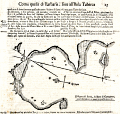 | Details | Coronelli, Vincenzo | 1697 |
| Antique chart of Cartagena Spain in Murcia by Coronelli |
|
Coronelli, Vincenzo |
|
| 1697 |
| LOC:8 |
| $325.00 | Coronelli--Vincenzo | Antique-chart-of-Cartagena-Spain-in-Murcia-by-Coronelli | Rare antique nautical chart of the harbor and anchorages near Cartagena, Spain in the region of Murcia. Simple, antique wood-cut print with profile view of the village of Cartagena, a compass rose, and soundings set in a much larger page of Italian text . Italian text also on verso largely consists of sailing directions ( distances and courses to steer between ports ).
<br></br>
Probably a copy by Coronelli derived from an atlas / pilot guide originally produced by the Genoan cartographer Francesco Maria Levanto in 1664 in "La Prima Parte dello Specchio del Mare…" . The Specchio del Mare was reissued later by Coronelli in 1697 and bears a strong similarity in paper, format, and typography to Coronelli's Isolario or Island Book. Charts from the Specchio del Mare are quite scarce and a small port plan such as this in text , even more scarce. Page 15. Chain laid paper. |
| 297 | 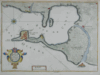 | Details | de Fer, Nicolas | 1700 |
| Isle Ville et Port de Cadis |
|
de Fer, Nicolas |
|
| 1700 |
| LOC:4 |
| $225.00 | de-Fer--Nicolas | Isle-Ville-et-Port-de-Cadis | Scarce antique map of the bay and island of Cadiz, Spain from ca. 1696 - 1708. This neat copperplate engraving is oriented to the north and shows some details of the city and port of Cadis including Pont. St Sebastien, Pte. Caterine, and Caleta. A single bridge is shown at the north end of the island : Pont de Suaco. Other habitations noted are Rota, (Rotta) Port Saint Marie, Port Real, Chiclana, Puntal, and Isle St. Pierre. Most of the island is shown covered by agricultural fields, apparently vineyards, labeled with rare praise (for a Frenchman) "ou croit le meilleur vin d'Espagne" translated very roughly as- 'thought to be the best Spanish wine'.<BR> </BR>
This antique map was produced toward the end of the 17th century by the well known French geographer and cartographer, Nicolas de Fer (1646 - 1720). De Fer was a prolific producer of maps and prints who among other honors, was appointed as official geographer to the Spanish King in 1702. |
| 1376 | 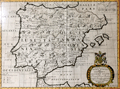 | Details | Wells, Edward | 1700 |
| Interesting antique map of Spain or Celtiberia |
|
Wells, Edward |
|
| 1700 |
| LOC:0 |
| $350.00 | Wells--Edward | Interesting-antique-map-of-Spain-or-Celtiberia | Highly interesting framed intaglio engraved map of Spain ca. 1700 with names of the provinces of that era. Old color and the engraver's use of bold strokes with large and decorative typefaces makes this antique map a joy to study. The Celtiberians were a group of Celts in the central-eastern Iberian Peninsula ca. 200 BC.
<br></br>
By Edward Wells (1667 - 1727) and dedicated to William, Duke of Glouchester, upon his death from encephalitis at age 11. Bears the Duke's coat-of-arms above the scrollwork title. Engraved by R. Spofforth.
<br></br>
With frame the engraving measures 22.5" x 17.5". Packaging and ground shipping within USA: $45. |
| 992 | 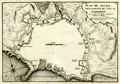 | Details | de Fer, Nicolas | 1715 |
| Old plan of Palma, Majorca or Mallorca, Spain |
|
de Fer, Nicolas |
|
| 1715 |
| LOC:4 |
| $495.00 | de-Fer--Nicolas | Old-plan-of-Palma--Majorca-or-Mallorca--Spain | Attractive, detailed antique birds-eye view or plan of Palma the capital of Mallorca / Majorca, now part of Spain. Features the walls, gates, roads, and numerous Vauban-style defenses that surrounded Palma / Palme in the early 18th century. Majorca is the largest of Spain's Balearic Islands, located south of Barcelona in the Mediterranean Sea. Will frame and display nicely.
<br></br>
Numerous defensive bastions are numbered and the key roads leading into the city are named including:
Chemin de Plumayor, Chemin de Manacor, Chemin d'Inca, Chemin Banola, and Chemin de Soller. City gates are also named including: Puerta de Jesus, Puerta Santa Catarina, Puerta de Campo, Puerta St. Antoine, Puerta Pintada, and Porte au Mole, leading to a jetty in the harbor. Additional defensive works under construction are shown with dotted lines. At the northeast, a single stream leading into the city walls is shown connected to a short aqueduct.
<br></br>
This antique copperplate-engraved map was produced toward the end of the 17th century by the well known French geographer and cartographer, Nicolas de Fer (1646 - 1720). De Fer was a prolific producer of maps and prints who among other honors, was appointed as official geographer to the Spansh King in 1702.Dated within at 1715. From de Fer's "Forces de l'Europe ou Introduction a la Fortification".
<br></br>
Plate No. 69. |
| 347 |  | Details | Michelot and Bremond | 1718 |
| Baye de Cadiz et Detroit de Gibraltar |
|
Michelot and Bremond |
|
| 1718 |
| LOC:57 |
| $900.00 | Michelot-and-Bremond | Baye-de-Cadiz-et-Detroit-de-Gibraltar | From the perspective of this writer this antique nautical chart of Cadiz and the Strait of Gibraltar is the most important chart of the 16 large Mediterranean sea charts by <a style="color:#9BAFCB" rel="nofollow" href= "/MichelotBremondBackground.aspx">Henry Michelot and Laurens Bremond</a> . The chart bears the earliest date of any of the 16 that were published - 1718. Also, the large decorative title cartouche at the upper left is reflective of Michelot's rank and symbols of high status. Michelot describes himself as “Hydrographe et Pilote Real des Galères du Roy” (hydrographer and pilot of the royal galley for the kings galley corps).
<BR> </BR>
The vessel depicted in the cartouche is clearly the "Reale" or Royal Galley (galère, Fr.) with three large stern lanterns. These distinctive lights served at night as a reference point for the fleet to follow. Above the galley, at the center top of the cartouche are the coat of arms of the French King surrounded on both sides by numerous banners and weapons including cannon and pikes. Perhaps the most unusual and significant decorative element is the two captive Muslim prisoners. Along with the opulent galley and other power icons the image of these near naked, chained ‘infidel’ captives would have been intended to demonstrate the map maker’s high status and authority to the map’s audience and as Petto points out, to reflect glory onto the map-makers patron to whom the charts were dedicated.<BR> </BR>
With an inset legend and a single large very decorative central compass rose and rhumb lines. Includes San Lucar de Barameda, Rota, Cape Trafalgar, Ceuta, Tangiers, Tarife (Tarifa) Gibraltar, Puerto Santa Maria and the hills of Medina Sidonia. Perhaps more than any other chart from the pair of Marseilles-based cartographers the numerous guard towers, soundings, and marked anchorages would have been important to the intended constituency for this chart- galley pilots and other coastal navigators of that period. |
| 2511 |  | Details | Michelot and Bremond | 1723 |
| Carte Particuliere des cotes D'Espagne et de Barbarie |
|
Michelot and Bremond |
|
| 1723 |
| LOC:0 |
| $1,850.00 | Michelot-and-Bremond | Carte-Particuliere-des-cotes-D-Espagne-et-de-Barbarie | Antique, attractive early 18th-century working portolan-style nautical chart of the western Mediterranean Sea with the southern coasts of France and Spain. This original rare nautical chart was produced by Henri Michelot and Laurent Bremond, who had close, first-hand experience with many of the areas they charted.
<BR> </BR>
Chart coverage includes the Mediterranean coasts of Europe and Africa (Barbarie) from the Strait of Gibraltar and Ceuta in the west through Marbella, Malaga, Almeria and Cartagena to Cap Palle in the east. Dozens of guard towers are noted along the coast; they would have been crucial during that era of intense raiding from the Barbary coast. Includes two large insets, one of Gibraltar and the other of the Bay of Tangier (Tanger). <BR> </BR> Some unique features not found in other <a rel="nofollow" href= "/MichelotBremondBackground.aspx">Michelot and Bremond</a> antique nautical charts include a depiction of a navigator (Michelot?) sitting atop bales of merchandise embellished with initials and symbols related to the authors and engraver, and surrounded by maritime objects and navigational instruments including chart, compass and cross-staff. A separate and unexplained distance scale is included inside the neatline near bottom left. As these additional scales are found only on small-scale charts, their probable intended usage is for navigators' placement of divider points so as not to damage the master distance scale by repeated pricking. |
| 49 |  | Details | Michelot and Bremond | 1727 |
| Plan du Port de Cartagena |
|
Michelot and Bremond |
|
| 1727 |
| LOC:4 |
| $300.00 | Michelot-and-Bremond | Plan-du-Port-de-Cartagena | Large-scale original, antique chart / plan from galley pilot Henri Michelot and Laurens Bremond of the Mediterranean harbor and town of Cartagena, Spain. Very attractive pictorial profile view of Cartagena as it looked at that time surrounded by city walls at the beach and by hills to the east. The "Petit Fort" is shown guarding the entrance to the harbor. Other features that Michelot references by name include: "le Chateau", the "Masse de Moulin", a "Grotte ou Caverne", the "Grand Valong" and "l'Ermitage" to the east of Cartagena.
<BR> </BR>
Single compass rose with rhumb lines. Numerous soundings include several warnings about a dangerous area. See also the offered large-scale antique chart of the anchorage of Escombreras ("Rade d'Ascombrera") which provides detail of the environs along roughly a seven-mile stretch of coastline directly south of Cartagena. |
| 817 | 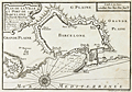 | Details | Michelot and Bremond | 1727 |
| Barcelona, Spain port and fortification plan |
|
Michelot and Bremond |
|
| 1727 |
| LOC:4 |
| $200.00 | Michelot-and-Bremond | Barcelona--Spain-port-and-fortification-plan | One of the first port plans of Barcelona, Spain (from 1727) created for navigational purposes in an atlas for the Mediterranean Sea: “Recueil de Plusiers Plans des Ports et Rades de la Mer Mediterranee". This chart was published by the team of Henri Michelot and Laurens Bremond, both associated with the French Royal Galley Corps. In their business relationship it appears that Bremond provided the retail space in the port of Marseille, France where this chart, as well as other atlases and nautical prints were sold. Michelot, the chief pilot or "Pilote Hauturière" for the galley service provided the name recognition and authority needed for the charts to sell widely.
<br></br>
The chart covers from Mont-Jouy ( Montjuïc ) in the West to the far Eastern walls at Barcelona's edge. The chart shows Barcelona's fortifications with numerous bastions; redoubts, gun batteries, windmills, the arsenal, and 5 entrances into the city: the Porte de Mont-Jout; Porte St. Antoine; Porte de l'Ange; Porte Neuve; and Porte de la Marine, near the harbor. Depth soundings extend only in the interior harbor, and are interspersed with anchor symbols reflecting locations where sea-going vessels could find shelter. In the title cartouche the authors note that the plan is based on the state they observed in 1697, likely during Michelot's service for the Louis XIV's Corps des Galeres. |
| 251 | 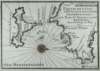 | Details | Michelot and Bremond | 1727 |
| Partie de l'Isle d'Yvice et des Isles Fromentieres (Ibiza and Formentera islands) |
|
Michelot and Bremond |
|
| 1727 |
| LOC:0 |
| $0.00 | Michelot-and-Bremond | Partie-de-l-Isle-d-Yvice-et-des-Isles-Fromentieres-(Ibiza-and-Formentera-islands) | <a rel="nofollow" href= "http://www.rarecharts.com/ShowDetail/Creator/Michelot-and-Bremond/Title/Antique-chart-of-the-Balearic-Islands-of-Ibiza-and-Formentera/819"> SOLD, but see another copy in our stock.</a> <BR> </BR>
Original small engraved nautical chart of the Balearic islands of Ibiza and Formentera which now belong to an autonomous unit and province of Spain. Shows the port and the town of Elvissa which is labeled "Yvice". This chart is one of 37 port plans published by <a style="color:#9BAFCB" rel="nofollow" href= "/MichelotBremondBackground.aspx">Henry Michelot and Laurens Bremond</a> ca. 1730 in their atlas of small scale Mediterranean ports: "Recueil de Plusieurs Plans de Ports et Rades de la Mer Mediterranée" . <BR> </BR>
Contains a carefully colored compass rose. |
| 270 | 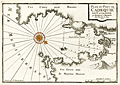 | Details | Michelot and Bremond | 1727 |
| Plan du Port de Cadequie en Catalogne |
|
Michelot and Bremond |
|
| 1727 |
| LOC:4 |
| $365.00 | Michelot-and-Bremond | Plan-du-Port-de-Cadequie-en-Catalogne | Old, rare antique nautical chart of Cadaqués, on the Costa Brava ("rough coast") of the Mediterranean Sea in Catalunya Spain. This antique 18th century antique sea chart covers the Bay of Cadeques and this northern Spanish port along with a few of the nearby mountains in the vicinity of Cape Creus. The chart shows but does not name Cadeques' only inhabited island: Isla S'Arenella.
<BR> </BR>
This among several large-scale charts of Spanish ports in Michelot's and Bremond's important 37-plate atlas of 1730: <a id="A3" href="http://www.rarecharts.com/ShowDetail/Creator/Michelot-and-Bremond/Title/Recueil-de-plusieurs-plans-des-ports-et-rades-de-la-mer-mediterranee---(Atlas-of-37-plates)/230" onclick="_gaq.push(['_trackEvent', 'Michelot and Bremond, 'View All', 'MichelotBremondBackground']);">
“Recueil de Plusiers Plans des Ports et Rades de la Mer Mediterranee". </a>
</br></br>
Single colored compass rose with rhumb lines. Numerous soundings.
<BR> </BR>
<p><a style="color:#9BAFCB" rel="nofollow" href= "/Creator/Michelot-and-Bremond">[All Items by Henry Michelot and Laurens Bremond]</a> </p> |
| 271 | 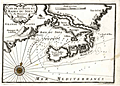 | Details | Michelot and Bremond | 1727 |
| Plan de la Baye et Rades du Sofa |
|
Michelot and Bremond |
|
| 1727 |
| LOC:4 |
| $350.00 | Michelot-and-Bremond | Plan-de-la-Baye-et-Rades-du-Sofa | Scarce large-scale antique copperplate Mediterranean / Balearic sea chart of the coast surrounding the Bay of Sofa from galley pilot Henri Michelot and Laurens Bremond. Coverage of the coast of Catalunya Spain from Les Cases de Alcanar to past the Tortosa (Tortose) river to approximately Riumar. Chart details include Serra del Montsià, Amposta (Emposta), Sant Carles de la Rapita, and the salinas.
<BR> </BR>
A monastery and numerous guard towers are identified as is a "source d'eau", of great importance to those traveling aboard the galleys which held only enough water for two weeks at best.
<BR> </BR>
Single colored compass rose with rhumb lines. Numerous soundings.
<BR> </BR>
<p><a style="color:#9BAFCB" rel="nofollow" href= "/Creator/Michelot-and-Bremond">[All Items by Henry Michelot and Laurens Bremond]</a> </p> |
| 333 | 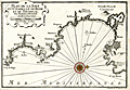 | Details | Michelot and Bremond | 1727 |
| Plan de la Baye et Citadelle de Rose et de Tourrille |
|
Michelot and Bremond |
|
| 1727 |
| LOC:4 |
| $375.00 | Michelot-and-Bremond | Plan-de-la-Baye-et-Citadelle-de-Rose-et-de-Tourrille | Interesting original antique nautical chart / plan of the vicinity of Roses, Spain from Cap de Begu (Cabo Begur) past the Riviere du Ter (el Ter river), Roses to Calla Figuire where it is noted that water could be obtained. Other features that Michelot and Bremond captured include l'Estardiez (L'Estarit), Tour de Mongon, Emporia, St Pierre le Pescador, Lescalle (L'Escala), Castillon, and the tiny Illes des Medes.
<BR> </BR>
This antique chart was produced ca. 1727 by French hydrographer and pilot of the French royal galley "La Reale" <a style="color:#9BAFCB" rel="nofollow" href= "/MichelotBremondBackground.aspx">Henry Michelot</a>. The port plan was one of 37 original plans published in Marseilles by Michelot and Laurens Bremond in a volume titled "Recueil de Plusieurs Plans de Ports et Rades de la Mer Mediterranée." Later in the 18th century the plans were copied and reprinted by Roux, Allezard, Kitchin and others. |
| 818 | 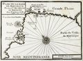 | Details | Michelot and Bremond | 1730 |
| Bay of Palma, on Mallorca, Spain (Balearics) |
|
Michelot and Bremond |
|
| 1730 |
| LOC:4 |
| $200.00 | Michelot-and-Bremond | Bay-of-Palma--on-Mallorca--Spain-(Balearics) | One of the first port plans of the Bay of Palma, Spain (1730) on the Balearic Island of Mallorca (Majorca) created for navigational purposes in an atlas for the Mediterranean Sea: “Recueil de Plusiers Plans des Ports et Rades de la Mer Mediterranee". The chart covers from Fort de Porto pin in the West to the far plains east of Palma ( "Palme") . Shows the region around Palama including fortifications, bastions, redoubts, gun batteries, and numerous windmills both to the east and west of the city. The Bay of Palma is referred to as the "Golfe de Mayorque".
<br></br>
This chart was published by the team of Henri Michelot and Laurens Bremond, both associated with the French Royal Galley Corps. In their business relationship it appears that Bremond provided the retail space in the port of Marseille, France where this chart, as well as other atlases and nautical prints were sold. Michelot, the chief pilot or "Pilote Hauturière" for the galley service provided the name recognition and authority needed for the charts to sell widely. |
| 819 |  | Details | Michelot and Bremond | 1730 |
| Antique chart of the Balearic Islands of Ibiza and Formentera |
|
Michelot and Bremond |
|
| 1730 |
| LOC:4 |
| $200.00 | Michelot-and-Bremond | Antique-chart-of-the-Balearic-Islands-of-Ibiza-and-Formentera | Original engraved antique nautical chart of the Balearic islands of Ibiza and Formentera which now belong to an autonomous unit and province of Spain. The French chart, from 1730, shows the port and the town of Eivissa or Ibiza Town which is labeled "Yvice". Other noted points of interest include: Cap Saline, Porto Magno or Galache Fraques, Ile de Tagomago, and Ile Espalmador. Numerous soundings , anchorages, and rocks are noted as well as a water source near the village of St. Hilaire.
<BR> </BR>
This chart is one of 37 port plans published by <a style="color:#9BAFCB" rel="nofollow" href= "/MichelotBremondBackground.aspx">Henry Michelot and Laurens Bremond</a> ca. 1730 in their atlas of small scale Mediterranean ports: "Recueil de Plusieurs Plans de Ports et Rades de la Mer Mediterranée" . Both Michelot and Bremond were associated with the French Royal Galley Corps. In their business relationship it appears that Bremond provided the retail space in the port of Marseille, France where this chart, as well as other atlases and nautical prints were sold. Michelot, the chief pilot or "Pilote Hauturière" for the Corps des Galeres provided the name recognition and authority needed for the charts to sell widely. |
| 4707 |  | Details | Michelot and Bremond | 1730 |
| Antique French nautical chart of Ibiza and Formentera, Balearic Islands, Spain |
|
Michelot and Bremond |
|
| 1730 |
| LOC:13 |
| $350.00 | Michelot-and-Bremond | Antique-French-nautical-chart-of-Ibiza-and-Formentera--Balearic-Islands--Spain | Attractive and authentic antique engraved nautical chart of the <b>Balearic islands of Ibiza and Formentera, Spain.</b> Includes the noted locations of St. Hilaire, Porto Magno, Cap Saline, Isle des Salines, and Isle Tagomago. The authors identify anchorages, navigation hazards, depth soundings, watering locations, and a shallow northern passage between the islands labeled "on peut passer ici par un beau tems." Shows the port and the town of Elvissa labeled "Yvice".
<BR> </BR>
This small antique chart is one of 37 port plans and harbor charts published by Henry Michelot and Laurens Bremond ca. 1730 in their small-scale atlas of Mediterranean ports: "Recueil de Plusieurs Plans de Ports et Rades de la Mer Mediterranée."
<BR> </BR>
Contains a carefully colored compass rose with north oriented to the right, |
| 218 |  | Details | Bolland, Richard | 1730 |
| The Straites Mouth of Gibralter |
|
Bolland, Richard |
|
| 1730 |
| LOC:8 |
| $675.00 | Bolland--Richard | The-Straites-Mouth-of-Gibralter | Antique hydrographic chart of the Strait of Gibraltar including both Spanish and Moroccan coasts created by Captain Richard Bolland to illustrate his systematic hydrographic description of the currents and tidal flows in that area. Bolland's work, "A Draught of the Streights of Gibraltar with Some Observations upon the Currents thereunto Belonging", dated July 24, 1675 was based on Bolland's first-hand observations and measurements while living in Tangiers for nine years. The chart includes substantial tide tables and information on currents in the Strait.<BR> </BR>
This work of Bolland is clearly the source of Mortier's later similar engraving of the Strait published ca. 1705. Mortier pirated this work to publish in Amsterdam along with many other works in an age before international copyright law. <BR> </BR>
Published (and attributed to Bolland) by Awnsham and John Churchill ca. 1704 at the end of Volume 4 of their publication: "A Collection of Voyages and Travels". Page 777. English text. Verso blank. <BR> </BR>
Online copy of Bolland's text provides interesting background for the methodology that Bolland used to develop the chart (http://www.canadiana.org/view/33300/812 ). |
| 253 |  | Details | Michelot and Bremond | 1730 |
| Plan de la Baye et Rades de Cadis et des Environs (Cadiz) |
|
Michelot and Bremond |
|
| 1730 |
| LOC:4 |
| $300.00 | Michelot-and-Bremond | Plan-de-la-Baye-et-Rades-de-Cadis-et-des-Environs--(Cadiz) | Highly detailed antique chart of Cadiz, Spain from Rota to Chiclana showing guard towers, water sources, salt pans, and defenses with prominent topographical features drawn pictorially. Among the many noted habitations are: Medina (Medina-Sidonia), Rota (Rotta), St. Maria, Chiclana, and Puerto Real. Other features include Tour (tower) St. Sebastien, Tours d'Hercule, Canal de St. Pierre (with locations where galleons we built and careened), , Tour Vermea, Fort Matagord, Fort St. Laurent, and the Isle de Tour de St. Pierre.
<BR> </BR>
Of special note is the hilltop village of Medina (Medina-Sidonia) used as a range marker for the main channel into the Bay of Cadiz. That village has a history that dates back to Roman times and was the ancestral home to the Duke of Medina Sidonia who reluctantly led and lost the Spanish "Invincible" Armada on a planned invasion of England in 1588.
<br></br>
This old chart and port plan of Cadiz is one of a handful of Michelot and Bremond charts that were copied by Thomas Kitchin and others for more than 30 years and it should be a part of any serious collection of maps from that region. The charts were published from Marseilles in Michelot's and Bremond's important 37-plate atlas of 1730: <a id="A3" href="http://www.rarecharts.com/ShowDetail/Creator/Michelot-and-Bremond/Title/Recueil-de-plusieurs-plans-des-ports-et-rades-de-la-mer-mediterranee---(Atlas-of-37-plates)/230" onclick="_gaq.push(['_trackEvent', 'Michelot and Bremond, 'View All', 'MichelotBremondBackground']);">
“Recueil de Plusiers Plans des Ports et Rades de la Mer Mediterranee". </a>
<BR> </BR>
Numerous soundings, underwater hazards, and anchorages are noted. Colored compass rose. |
| 47 |  | Details | Michelot and Bremond | 1730 |
| Plan de la Rade d'Alicant |
|
Michelot and Bremond |
|
| 1730 |
| LOC:4 |
| $300.00 | Michelot-and-Bremond | Plan-de-la-Rade-d-Alicant | Antique copperplate portulan-style nautical chart / plan of Alicante, Spain and nearby waters.
<BR> </BR>
This chart is one of 37 port plans published by <a rel="nofollow" href= "/MichelotBremondBackground.aspx">Henry Michelot and Laurens Bremond</a> ca. 1730 in their atlas of small scale Mediterranean ports: "Recueil de Plusieurs Plans de Ports et Rades de la Mer Mediterranée" . Single compass rose with radiating rhumb lines and fleur de lis indicating north. Charming profile view of Alicante topped by "le Chateau". Chart coverage extends eastward from a guard tower past Cap de la Houerta and ends at the prominent villa "la Ste. Face ou la Veronique".<BR> </BR>
Obligatory '+' symbols for rock at every headland and few soundings suggest that the authors were not as familiar with these waters as with other areas they charted. Three suggested anchorages are designated. These anchorages are arranged as expected by the relative draft of each vessel. The "mouillage de vaisseaux" is farthest from shore, with the "mouillage des barques" and "mouillage des galeres" each in progressively shallower water. |
| 48 |  | Details | Michelot and Bremond | 1730 |
| Plan de la Rade d'Ascombrera |
|
Michelot and Bremond |
|
| 1730 |
| LOC:4 |
| $300.00 | Michelot-and-Bremond | Plan-de-la-Rade-d-Ascombrera | Large-scale antique copperplate-engraved nautical chart / plan of waters offshore Cartagena, Spain from French galley pilot and hydrographer <a rel="nofollow" href= "/MichelotBremondBackground.aspx">Henri Michelot.</a> Coverage extends roughly from Cabo Tinoso (Cap-Tignoso) past Cartagena, Spain; Escombrera Island and Bay, and ends in the east near Cabo del Aqua. Single compass rose with rhumb lines radiating in all directions. Highlight detail includes the "Chapelle des Galères" not too far from a beach at the head of Escombrera bay. <BR> </BR>
See also the related large-scale <a rel="nofollow" href= "/ShowDetail/Creator/Michelot-and-Bremond/Title/Plan-du-Port-de-Cartagena/49">antique chart / plan of Cartagena, Spain</a> which provides detail of the city and the harbor directly south of Cartagena. When framed both charts together would make an attractive grouping. |
| 580 |  | Details | Homann, Johann | 1745 |
| Regnorum Hispaniae et Portugalliae |
|
Homann, Johann |
|
| 1745 |
| LOC:0 |
| $0.00 | Homann--Johann | Regnorum-Hispaniae-et-Portugalliae | SOLD
<br></br>
Old antique map of Spain and Portugal divided into provinces, with the Balearic Islands of Ibiza, Mallorca ( Majorca ), and Minorca ( Menorca ). Coverage includes the Strait of Gibraltar, southern France and the coast of North Africa. This antique, copperplate engraved map ca. 1745 has old hand color and a decorative title cartouche with coats of arms for many of the provinces shown on the map.
<br></br>
Drawn by famous German cartographer Johann Homann, the antique map was published by the firm Homann Heirs. Homann Heirs (also "Homannianis Heredibus" or "Homann Erben" or "Heritiers de Homann") was a company established after the death of Homann to carry on the map publishing business of the firm he started in the early 1700's. The designation "Homann Heirs" appears on maps published by that successor firm from about 1730 to 1848. |
| 183 |  | Details | Ayrouard, Jacques | 1746 |
| Plan de la Port de Cartagene |
|
Ayrouard, Jacques |
|
| 1746 |
| LOC:8 |
| $450.00 | Ayrouard--Jacques | Plan-de-la-Port-de-Cartagene | This antique nautical chart or plan of the town and harbor of Cartagena, Spain by Jacques Ayrouard (Marseilles ca. 1732- 1746) is sourced from a scarce sea atlas titled: "Recueil de Plusiers Plans des Ports et Rades et de Quelque Cartes Particulieres de la Mer Méditerranée". Beautifully engraved by Louis Corne this copperplate engraving shows the town of Cartagena surrounded by defensive walls, and unusually for 18th century charts/plans shows the adjacent topography in great detail.
<br></br>
Like <a rel="nofollow" href= "/MichelotBremondBackground.aspx">Henry Michelot</a> before him, Ayrouard was a pilot of the French royal galley, the Reale, based in Marseille. However, Ayrouard's port plans are very different from Michelot's earlier works. The much larger size (18"x11") and extensively shaded topography in this plan are distinctive characteristics of Ayrouard's nautical plans. Plate 68. <BR> </BR> |
| 6774 |  | Details | Ayrouard, Jacques | 1746 |
| Plan du Port de Cartagene |
|
Ayrouard, Jacques |
|
| 1746 |
| LOC:8 |
| $375.00 | Ayrouard--Jacques | Plan-du-Port-de-Cartagene | Fine nautical chart or plan of the town and harbor of Cartagena, Spain by Jacques Ayrouard (Marseilles ca. 1732- 1746). Original copperplate engraving shows the town of Cartagena surrounded by defensive walls, and unusually for 18th century charts/plans shows the adjacent topography in great detail. Noted features include l'Hermitage", "le Chateau", "pointe du fort", and "pointe galere" near a "chapelle".
<br></br>
<div id="0" align="center">
<a title=""></a>
<img id="6774" src="/ZoomifyImages/SC_6774/SC_6774_detail_1.jpg" alt="Plan du Port de Cartagene a nautical port plan for Cartagena, Spain by Jacques Ayrouard 1746." width="340"/> <br><br> <font size="-2">View of Cartagena, Spain by Ayrouard, 1746.</font>
</div><br>
Sourced from Ayrouard's scarce sea atlas: "Recueil de Plusiers Plans des Ports et Rades et de Quelque Cartes Particulieres de la Mer Méditerranée." Beautifully engraved by Louis Corne.
<br></br>
Ayrouard was a pilot of the French royal galley, the Reale, based in Marseille, France. The much larger size (18"x11") and extensively shaded topography in this plan are distinctive characteristics of Ayrouard's nautical port plans. Plate 68. <BR> </BR> |
| 182 |  | Details | Ayrouard, Jacques | 1746 |
| Plan de la Baye d'Alicant |
|
Ayrouard, Jacques |
|
| 1746 |
| LOC:8 |
| $375.00 | Ayrouard--Jacques | Plan-de-la-Baye-d-Alicant | This antique, black and white harbor chart /port plan of Alicante Bay, Spain is by Jacques Ayrouard (Marseilles ca. 1732- 1746) from a scarce atlas titled: "Recueil de Plusiers Plans des Ports et Rades et de Quelque Cartes Particulieres de la Mer Méditerranée". Coverage extends eastward from Cap St. Paul to past Cap de la Houerta. Engraved by Louis Corne. Plate 67. <BR> </BR>
Little information exists on Ayrouard's background but like Henry Michelot before him, Ayrouard was a pilot of the French royal galley, the Reale, based in Marseille. However, Ayrouard's port plans are very different from Michelot's earlier works. The much larger size (18"x11") and extensively shaded topography in this plan are distinctive characteristics of Ayrouard's nautical plans. <BR> </BR> |
| 1378 |  | Details | Ayrouard, Jacques | 1746 |
| Scarce antique port plan of Barcelona, Spain |
|
Ayrouard, Jacques |
|
| 1746 |
| LOC:8 |
| $700.00 | Ayrouard--Jacques | Scarce-antique-port-plan-of-Barcelona--Spain | Scarce antique French port plan / chart for the town of Barcelona, Spain on Spain's Mediterranean coast. This expertly designed and robustly executed antique chart is by Jacques Ayrouard (Marseilles ca. 1732- 1746) from a scarce atlas titled: "Recueil de Plusiers Plans des Ports et Rades et de Quelque Cartes Particulieres de la Mer Mediterranee". In a style that reflects Ayrouard's military and engineering background.
<br></br>
In the attribution Ayrouard is described as "Pilote Real" or pilot of la Reale, the flagship of the French galley corps with a total complement of about 550 including 360 oarsmen and 100 soldiers. In their <i>Dictionnaire de la Marine</i> from 1702 Covens and Mortier explain: <div class="indenttextblock">"(Réale) is the name of the main galley of an independent kingdom, not of a tributary kingdom annexed to a greater one. The Réale, in France, is reserved for the general of the galleys and flies the royal ensign which distinguishes it from the others. This ensign is square in shape and red in colour, with golden fleurs-de-lys." <a href="http://www.ulmo.net/bateaux/reale/dico02.jpg" target="_blank"> (Internet)</a> </div>
Ayrouard was likely one of the last such pilots as the French Corps des Galeres was disbanded in 1748 and incorporated into the regular French sailing navy. |
| 543 | 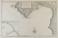 | Details | Ayrouard, Jacques | 1746 |
| Plan de la Baye et Port de Mayorque (Palma Majorca or Mallorca) |
|
Ayrouard, Jacques |
|
| 1746 |
| LOC:8 |
| $600.00 | Ayrouard--Jacques | Plan-de-la-Baye-et-Port-de-Mayorque-(Palma-Majorca-or-Mallorca) | Antique original engraved chart of the northwest portion of the island of Mallorca, Spain, the largest of the Balearic islands in the Mediterranean sea. Includes the capital city, Palma surrounded by a wall, and the Bay of Palma. Coverage extends from the "Cote de Solery" and Sa Dragonera (with two watchtowers shown) past the Bay of Palma to "Cap Blanc". A detailed inset includes the area at the harbor in Palma, "la mole", a jetty or breakwater where according to Ayrouard there was room to moor 5 galleys stern-first, as is still the custom in the Mediterranean: "en grande point, on peut y placer 5 galeres la poupe au mole en quatres amarres." <br><br/>
This rare chart by Jacques Ayrouard (Marseilles ca. 1730) comes from a scarce nautical atlas: "Recueil de Plusiers Plans des Ports et Rades et de Quelque Cartes Particulieres de la Mer Mediterranee". <br><br/>
Little information exists on Ayrouard's background but like <a style="color:#9BAFCB" rel="nofollow" href= "/MichelotBremondBackground.aspx">Henry Michelot </a> two decades earlier, Ayrouard was a pilot of the French royal galley, the Reale, based in Marseille. Ayrouard's port plans and charts are very different from Michelot's earlier works; the much larger size (17"x11") and the extensively shaded topography enable the viewer to easily recognize Ayrouard's plans. Large compass rose with fleur-de-lis. Plate 70 but manuscript notation at upper left reads "No. 69". |
| 1073 |  | Details | Homann Heirs | 1756 |
| Plan of the town and port of Mahon on Minorca |
|
Homann Heirs |
|
| 1756 |
| LOC:58 |
| $1,050.00 | Homann-Heirs | Plan-of-the-town-and-port-of-Mahon-on-Minorca | Spectacular antique engraved port plan of the harbor, town, and defences of Mahon, the capital city of Menorca ( Minorca ) one of the Balearic Islands in the Mediterranean Sea, belonging to Spain. This attractive chart shows great detail of the interior of the island with delineation of hills, roads, streams and individual fields. Printed on 2 separate sheets each measuring approximately 18" x 18".
<br></br>
Britain captured and occupied Minorca beginning in 1708 until 1756 (year this chart was published) when France captured the island after the Siege of Fort St. Philip, led by the Duke de Richelieu, of France.
<br></br>
Two charts on separate sheets, not joined. Insets: Plan of Fort St. Philippe; cross-section of Fort St. Philippe.
<br></br>
Published in Nuremberg by Homann Heirs (also "Homannianis Heredibus" or "Homann Erben" or "Heritiers de Homann"), a company established after the death of German cartographer J.B. Homann to carry on the map publishing business of the firm he started in the early 1700's. The designation "Homann Heirs" appears on maps published by that successor firm from about 1730 to 1848. |
| 850 | 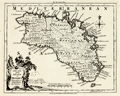 | Details | Kitchin, Thomas | 1756 |
| Antique Map of the Balearic Island of Menorca or Minorca |
|
Kitchin, Thomas |
|
| 1756 |
| LOC:0 |
| $0.00 | Kitchin--Thomas | Antique-Map-of-the-Balearic-Island-of-Menorca-or-Minorca | SOLD<br></br>
Detailed antique map of the island of Menorca ("Minorca"), one of Spain's Balearic Islands in the Mediterranean Sea. Some of the features that are noted on the map include: Governor of the Castles House, a Signal House, Mahon Harbor, Marlborough Redoubt, and St. Stephen's Cove.
<br></br>
From the London Magazine of March 1756 just a few months before the Battle of Minorca fought between the French and British fleets on May 20, 1756. The French won the battle. British Vice-Admiral John Byng had orders to relieve the garrison protecting Fort St. Philip in Port Mahon, but was court-martialed and later executed for failing to do enough to try to relieve the fort.
<br></br>
With text detached from the map for "A Description of the Island of Minorca" containing brief details of the history, geography, and inhabitants of the island. Published by R. Baldwin Pater Noster Row, London. 1756. Scale is 69 British Statute Miles to one degree of latitude. |
| 412 | 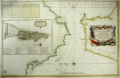 | Details | Bellin, Jacques Nicolas | 1761 |
| Carte du Detroit de Gibraltar |
|
Bellin, Jacques Nicolas |
|
| 1761 |
| LOC:58 |
| $900.00 | Bellin--Jacques-Nicolas | Carte-du-Detroit-de-Gibraltar | Large, handsome 251 year-old working sea-chart of the Strait of Gibraltar and surrounding areas by J.N. Bellin of the French Depot de la Marine. This stunning chart from 1761 contains a large cartouche at right embellished with pikes, shields, drums, flags, and other implements of war. At left is a detailed inset plan of Gibraltar with a legend keyed to locations on the plan. Table at top contains tidal flow data. North oriented to the left .<BR> </BR>
Coverage in Spain includes Rota, Cadiz (Cadix), Cape Trafalgar, Tariffa, Algeciras, and Gibraltar. Coverage of the coast of Africa ("Barbarie") includes Arzille, Cape Spartel, Cape Malbare, Tangiers, Ceuta, and Tetouan. Numerous soundings, hazards and guard towers are noted. With stamp of Depot de la Marine "R.F." . Price: Trente sols. |
| 186 |  | Details | Rocque, John | 1762 |
| A Plan of the City of Cadis - - - SOLD |
|
Rocque, John |
|
| 1762 |
| LOC:0 |
| $0.00 | Rocque--John | A-Plan-of-the-City-of-Cadis-------SOLD | THIS ITEM HAS BEEN SOLD <BR> </BR> Scarce and desirable antique plan of Cadiz, Spain published by Mary Anne Rocque, wife of engraver John Rocque, after her husband's death in 1762. The colorful engraved plan covers from Rota in the North to Chiclana in the South with an scroll inset of the town of Cadiz. Inset legend with descriptions of map locations. Numerous soundings and navigational hazards are identified.<BR> </BR>
John Rocque, born in France, had a long career during which he engraved and published maps and plans based on surveys he personally conducted of many English estates, cities and counties. Two of Rocque's best known achievements are a 24 sheet map of London published by John Pine and John Tinney in 1746 and a posthumously published "A Set of Plans and Forts in America Reduced from Actual Surveys". |
| 626 |  | Details | Roux, Joseph | 1764 |
| Ibiza and Formentera Spain |
|
Roux, Joseph |
|
| 1764 |
| LOC:4 |
| $190.00 | Roux--Joseph | Ibiza-and-Formentera-Spain | Antique engraved nautical chart of the harbor and town of Yvice ( Ibiza ) on the island of Ibiza, Spain. Coverage includes nearby Formentera ( Fromentiere ) Island.
<BR> </BR>
This small original chart is from the atlas of Mediterranean ports produced by Joseph Roux - "Recueil des Principaux Plans des Ports et Rades de la Mer Méditerranée".<BR> </BR>
There were at least four small atlases of port and coastal charts that originated from Marseille hydrographers in the 18th century. Beginning in approximately 1727 these atlases included works by cartographers
<a rel="nofollow" href= "/MichelotBremondBackground.aspx"> Michelot and Bremond</a>,
<a rel="nofollow" href= "/Creator/Ayrouard--Jacques"> Jacques Ayrouard</a>,
<a rel="nofollow" href= "/Creator/Roux--Joseph"> Joseph Roux</a>
, and Jean Allezard.
<br></br>
Comparison between Roux's chart and that of Michelot and Bremond shows that Roux copied Michelot's topography, anchorages, place names, and soundings directly from Michelot's chart that had been produced 40 years earlier. Plate 7. |
| 629 |  | Details | Roux, Joseph | 1764 |
| Antique harbor chart of Palma, Mallorca |
|
Roux, Joseph |
|
| 1764 |
| LOC:0 |
| $0.00 | Roux--Joseph | Antique-harbor-chart-of-Palma--Mallorca | SOLD
<BR> </BR>
Small and colorful mid 18th-century antique nautical chart of the harbor at Palma, Mallorca ( Majorca ), Spain. Coverage of this original copperplate-engraved harbor chart includes the walled village of Palma ( Palme ), the 'Tour de Lazaret' , Port Pin ( Porto Pi ), and the Vauban-style Fort de Port Pin. Several windmills are located as are soundings with suggested anchorages to aid early navigators unfamiliar with the area. Plate 8. <BR> </BR>
There were at least four small atlases of port and coastal charts that originated from Marseille hydrographers in the 18th century. Beginning in approximately 1727 these atlases included works by cartographers
<a rel="nofollow" href= "/MichelotBremondBackground.aspx"> Michelot and Bremond</a>,
<a rel="nofollow" href= "/Creator/Ayrouard--Jacques"> Jacques Ayrouard</a>,
<a rel="nofollow" href= "/Creator/Roux--Joseph"> Joseph Roux</a>
, and Jean Allezard. This small original chart is from the atlas of Mediterranean ports produced by Joseph Roux - "Recueil des Principaux Plans des Ports et Rades de la Mer Méditerranée". |
| 686 |  | Details | Santini, Paolo | 1776 |
| Balearic islands of Minorca, Majorca, Ibiza, Spain. |
|
Santini, Paolo |
|
| 1776 |
| LOC:0 |
| $0.00 | Santini--Paolo | Balearic-islands-of-Minorca--Majorca--Ibiza--Spain- | SOLD<BR> </BR>
Attractive old antique map of the Balearic Islands of Ibiza ( Catalan= Eivissa ), Majorca ( Mallorca ), and Minorca ( Menorca ). Coverage of dozens of villages and geographic features including: Isles Fromentieres, Ibiza village, Chateau St. Hilaire, Isle Cabraire, Baie d'Artas, Cap de Pedra, Isle Dragoniere, Cap Fromentelli, Port Colomb, Cap Mahon, Cap Bajoli, and Cap de Citadella. Sparse soundings and anchorages are identified.
<br></br>
Includes two inset maps: a) Detailed inset map (8" x 5") of the Port of Mahon, Majorca with Fort St. Philippe, Fort St. Charles, and the village of Mahon. 17 important locations are listed in a legend above the inset and tied to map locations though alphabetic references. b) Inset of the western Mediterranean showing the relative location of the three Balearic islands to other geographic features and to population centers. Contains a central compass rose with radiating rhumb lines.
<br></br>
By Paolo Santini after the work of Jacques Bellin of the French Depot de la Marine. From Santini's "Atlas Universel". Published from Venice, Italy ca. 1776. |
| 1134 | 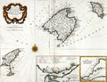 | Details | Santini, Paolo | 1776 |
| Antique Chart of the Balearic Islands of Minorca, Majorca, Ibiza, Formentera |
|
Santini, Paolo |
|
| 1776 |
| LOC:0 |
| $0.00 | Santini--Paolo | Antique-Chart-of-the-Balearic-Islands-of-Minorca--Majorca--Ibiza--Formentera | SOLD<br></br>Very attractive antique chart by Santini of Spain's Balearic Islands: Ibiza ( Yvice ), Majorca ( Maillorque ), Minorca ( Minorque ) and Formentera and other smaller islands in the archipelago. The archipelago forms an autonomous community and a province of Spain, with <b>Palma de Mallorca</b> as the capital.
<br></br>
Coverage on this scarce old map includes dozens of villages and geographic features including: Ibiza village, Chateau St. Hilaire, Isle Cabraire, Baie d'Artas, Cap de Pedra, Isle Dragoniere, Cap Fromentelli, Port Colomb, Cap Mahon, Cap Bajoli, and Cap de Citadella. Sparse soundings and anchorages are identified. Contains a central compass rose with radiating rhumb lines.
<br></br>
Includes two inset maps:
<div class="indenttextblock">
<ul style="list-style-type: circle;">
<li>Detailed inset map (8" x 5") "Plan du port et de la ville de Mahon". The inset includes the Port of Mahon, Majorca with Fort St. Philippe, Fort St. Charles, and the village of Mahon. 17 important locations are listed in a legend above the inset and tied to map locations though alphabetic references.
</li>
<li>
Inset of the western Mediterranean showing the relative location of the three Balearic islands to other geographic features and to population centers.
</li>
</ul>
</div>
By Paolo Santini after the cartography of J.N. Bellin of the French Depot de la Marine ca. 1740. From Santini's " Atlas Universal Dresse-Cartes Moderne". Published from Venice, Italy in 1776. |
| 119 | 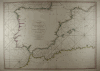 | Details | Rochette, Louis S. | 1780 |
| Coasts of Spain and Portugal |
|
Rochette, Louis S. |
|
| 1780 |
| LOC:0 |
| $0.00 | Rochette--Louis-S- | Coasts-of-Spain-and-Portugal | SOLD<br></br>
Small-scale antique nautical chart of the coasts of Spain and Portugal from Cabo Blanco along the African coast to the Bay of Gascogne. Includes the Western Mediterranean from Nice to the Strait of Gibraltar. As is typical for sea charts of that period the north coast of Africa is labeled "Barbary". Coverage of this antique chart of the western Mediterranean coast by Louis Rochette (1780) , includes the Balearic Islands of Ibiza, Majorca, Minorca, and Formentera. |
| 696 | 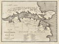 | Details | Cary, John | 1781 |
| Antique Plan of Mahon, Menorca, Spain |
|
Cary, John |
|
| 1781 |
| LOC:4 |
| $325.00 | Cary--John | Antique-Plan-of-Mahon--Menorca--Spain | Old antique engraved map and plan of the harbor and town of Mahon, the capital city of Menorca ( Minorca ) in the Balearic Islands, an archipelago and province of Spain in the Mediterranean Sea. Two areas of habitation are documented on the map, the largest consisting of the fortress and dwellings of St. Phillips town at the entrance to Mahon Harbor. In the vicinity of the fortress are a smaller structure- Charles Fort, St. Stephens Cove, Marlborough Redout, and just outside the walls, the Governor of the Castle's House.
<br></br>
Other noted points of interest around the harbor include Mast House, St. Anthony's Convent, Safron Island, Quarantine Island, Philipet Cove, Fort Philipet and a naval hospital on the aptly named "Bloody Island". A further 23 key points are noted and tied to a list of references at bottom with alphabetical indexes. These additional locations include: the Royal Counterguard, the Nunnery, and the Victualing Office for the Navy.
<br></br>
Admiral John Byng will forever be remembered for losing the island of Menorca to the French in 1756 near the beginning of what has come to be called "The Seven Years War". The island had been invaded and overrun by French forces with only Fort St. Philip remaining in British hands. Byng's failure to do his utmost to defeat the French fleet at the Battle of Minorca on May 20, 1756 and to recapture the fort and the island led to his court martial. Admiral Byng was found guilty and was later executed by firing squad on March 17, 1757 aboard the HMS Monarch while it lay at anchor in Portsmouth harbor.
<br></br>
Published from London by James Macgowan & William Davis. Dated within at Feb. 17, 1781. |
| 191 |  | Details | Tofino de San Miguel | 1786 |
| Plano Geometrico de la Bahia de Algeciras y Gibraltar |
|
Tofino de San Miguel |
|
| 1786 |
| LOC:0 |
| $0.00 | Tofino-de-San-Miguel | Plano-Geometrico-de-la-Bahia-de-Algeciras-y-Gibraltar | SOLD<br></br>
Scarce original Spanish antique nautical chart from Captain Vincente Tofiño de San Miguel y Van der Walle (1732-1795), Director of the Spanish Naval Academy in Cadiz. This old sea chart of the Bay of Gibraltar and Algeciras was one of 47 published in 1786 as part of the first scientific Spanish sea atlas: 'Atlas Maritimo de España' (Maritime Atlas of Spain) by the Dirección de Hidrografía, Spain's equivalent to the U.S. Coast Survey. Prior to the late 18th century Spain jealously guarded nautical maps and charts of its possessions, especially so for its overseas colonies.<br></br>
Attractive title cartouche at upper left contains a legend that identifies several dozen landmarks in and around the Bay of Gibraltar. <br></br>
Unlike other 18th century antique nautical charts that focus primarily on the coastal outline around the bay of Gibraltar, this old sea chart is notable for the extensive detailed engraving that is used to illustrate inland topographical details. This detail on inland areas, which is also evident in contemporary British charts from the same era (e.g. Faden), is likely related to the emphasis on land forces used in battles that occurred in this strategic location. During the siege of British occupied Gibraltar by Spanish and French forces during 1779 - 1783 , Spain and its allies are said to have fielded 35,000 ground troops in addition to the tens of thousands of sailors and marines aboard its naval fleet (80,000 spectators are said to have watched the grand assault of 1782 from locations in the surrounding hills). |
| 195 |  | Details | Anonymous | 1786 |
| Costa de Espana |
|
Anonymous |
|
| 1786 |
| LOC:0 |
| $340.00 | Anonymous | Costa-de-Espana | Set of antique profile coastal views of Spain's Costa del Sol and other coastal areas in the Mediterranean published as part of the first scientific sea atlas of Spain: 'Atlas Maritimo de España' (Maritime Atlas of Spain) by the Dirección de Hidrografía, Spain's equivalent to the U.S. Coast Survey in 1787. Included in this large dated sheet of land profiles from Tofino de San Miguel's atlas of antique nautical charts: Estepona; Punta de Velez, Malaga; Sierra d Marbella; Cabo de Gato; Cabo de Palos; Torre de Almazarron; Islands of Columbretes, Bedra and Benidorm; and many more coastal features. Sheet 1.
<br></br> The interested reader can find most of these profile locations described in an English-language translation of Tofino de San Miguel's sailing directions "Espana Maritima". This translation of San Miguel's work published in 1812 by Faden can be found online at: "http://books.google.com/books". |
| 187 | 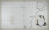 | Details | Tofino de San Miguel | 1788 |
| Carta Esferica de una Parte del Oceano Atlantico |
|
Tofino de San Miguel |
|
| 1788 |
| LOC:54 |
| $850.00 | Tofino-de-San-Miguel | Carta-Esferica-de-una-Parte-del-Oceano-Atlantico | Scarce, 18th century antique nautical chart published as part of the first scientific Spanish sea atlas: 'Atlas Maritimo de España' (Maritime Atlas of Spain) by the Dirección de Hidrografía, Spain's equivalent to the U.S. Coast Survey. This antique small-scale copperplate engraved chart by the renowned Spanish hydrographer Don Vincente Tofino de San Miguel (1732-1795) covers the coast of Spain and of Africa as far south as Cape Verde. Includes Cape Verde islands, Canary islands, the Azores. Coverage of the Western Mediterranean includes the Balearic islands with Ibiza, Mallorca ( Majorca ), and Minorca ( Menorca ).
<BR> </BR>
Picturesque dedicatory cartouche to Frey Don Antonio Valdes engraved by D. Fernando Selma includes palm trees, an anthropomorphic lion and two rabbits overlooked by crumbling columns bearing the inscribed national motto "Plus Ultra". |
| 4963 |  | Details | Tofino de San Miguel | 1789 |
| Antique Map of Cadiz Spain and Cape Trafalgar |
|
Tofino de San Miguel |
|
| 1789 |
| LOC:57 |
| $1,450.00 | Tofino-de-San-Miguel | Antique-Map-of-Cadiz-Spain-and-Cape-Trafalgar | Finely engraved and printed scarce original Spanish antique nautical chart of Cadiz, Spain and environs from Captain Vincente Tofiño de San Miguel y Van der Walle (1732-1795), Director of the Spanish Naval Academy in Cadiz. Manuscript pencil notations in English below the title cartouche suggest use aboard an English-speaking vessel.
<br></br>
This antique nautical chart of covering Cadiz, Spain to Cape Trafalgar was one of 47 charts published in 1789 as part of the first scientific Spanish sea atlas: 'Atlas Maritimo de España' (Maritime Atlas of Spain) by the Dirección de Hidrografía, Spain's equivalent to the U.S. Coast Survey. Prior to the late 18th century Spain jealously guarded nautical maps and charts of its possessions, especially so for its overseas colonies.
<br></br>
Drawn by Bauza. Grabado en Madrid por Joaquin Ballester. |
| 636 |  | Details | Depot de la Marine | 1793 |
| Cote Meridionale d'Espagne depuis Cadiz jusqu'au Cap de Palos |
|
Depot de la Marine |
|
| 1793 |
| LOC:0 |
| $900.00 | Depot-de-la-Marine | Cote-Meridionale-d-Espagne-depuis-Cadiz-jusqu-au-Cap-de-Palos | Exceptional antique French nautical chart of the Western Mediterranean Sea, including the southern coasts of Spain and France and the northern coast of Africa. Nearly perfect condition. Coverage on this handsome folding sea chart extends from Cadiz, Spain eastward past Cape Trafalgar, Gibraltar, Malaga, Cartagena, to Cape Palos. Hundreds of named towns, villages, and geographic features ring the coastline with depth soundings, but virtually no interior details. Latitude and longitude scales.
<br><br/>
With the circular stamp of the French Depot de la Marine. Price when issued: Three Francs. No. 93.
<br><br/>
Exterior of the original linen cover contains a decorative octagonal seller's label: "Ch. Piquet, Geographe ordinaire DU ROI et de S.A.R. Monseig(neur) le Duc d'Orleans. A Paris Quai de Conti No. 17, entre l'Hotel des Monnaies et le Pont des Arts." |
| 855 |  | Details | Depot de la Marine | 1799 |
| Old nautical chart of the harbor and town of Cartagena, Spain |
|
Depot de la Marine |
|
| 1799 |
| LOC:8 |
| $600.00 | Depot-de-la-Marine | Old-nautical-chart-of-the-harbor-and-town-of-Cartagena--Spain | Attractive antique harbor chart of Cartagena ( Carthagene ), Spain derived from the surveys of Admiral Don Vincente Tofiño de San Miguel. Noted geographical features of this plan of the port city of Cartagena on Spain's Mediterranean coast include Escombrera Bay ( Ensenada de Escombreras ) and Escombrera Island, Cartagena Harbor, "Montagne des Maures" ( Cerro de los Moros ) , "Petit Algameque" ( Algameca Chica ) , Plage des Chaloupes, and Cap Negrete.
<br></br>
Based on Tofino de San Miguel's chart which was originally published from Spain in the Atlas Maritimo de España in 1789. This later French edition was published by the French Depot General des Cartes et Plans in year 8 of the French revolution which dates it to roughly 1799 - 1800.
<br></br>
The chart contains much detail of both the terrain, local fortifications, and hydrographical features. A legend at top left contains several dozen entries keyed to military, religious, and secular locations of importance. Among these are "le Catedrale"- the cathedral; "Le Bagne"- the prison; "Depot de bois dans l'eau"- a series of connected pond-like pools near the shipyard where planking, spars and other lumber used in shipbuilding could be seasoned in water; "Pompe a Feu" - the fire pump; and numerous other entries. Sailing directions at top right. All text is in French. |
| 3688 | 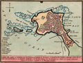 | Details | Luffman, John | 1800 |
| Antique map of Cadiz, Spain engraved for Luffman's Select Plans |
|
Luffman, John |
|
| 1800 |
| LOC:13 |
| $220.00 | Luffman--John | Antique-map-of-Cadiz--Spain-engraved-for-Luffman-s-Select-Plans | Fine copper-plate engraved plan of Cadiz, Spain not far from the Strait of Gibraltar. As described by Luffman: <div class="indenttextblock">
"Cadiz. The capital of Andalusia and the commercial capital of Old Spain is situated on the northern extremity of the Isle of Leon and Surrounded by an irregular fortification, but its best defence are the breakers by which it is nearly environed. Latitude 36 30 North. Longitude 6, 40 West from London"
</div>
</BR>
From "Luffman's Select Plans of the Principal Cities, Harbors, Forts etc. in the World". Engraved and published by John Luffman, No. 28 Little Bell Alley, Coleman Street, Cheapside, London. November 1, 1800. Volume I, Number 67.
<br></br>
Luffman also provided similar engravings to this at about the same time for J.T. Serres' "The Little Sea Torch: or, True Guide for Coasting Pilots." Serres translated the Little Sea Torch from an earlier illustrated coasting pilot guide, based on Bougard's "Le petit flambeau de la mer", first published in 1684.
<br></br>
John Luffman (1751-1821) began his career as an engraver, producing a very large and fine map of Antigua, where he had resided in 1787 and 1789. That map was published by Luffman to accompany his 'A Brief Account of the Island of Antigua', 1788." Luffman shared the same sad fate as many publishers and was declared bankrupt on 9th March, 1793. Moving forward Luffman was more cautious and produced small format atlases and handy-sized maps of the theatres of war, principal towns and cities and battle-plans relating to the Wars of the French directorate and the subsequent Napoleonic War. |
| 4850 | 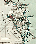 | Details | Luffman, John | 1801 |
| Antique map of Cadiz Harbour, Spain |
|
Luffman, John |
|
| 1801 |
| LOC:0 |
| $250.00 | Luffman--John | Antique-map-of-Cadiz-Harbour--Spain | Fine copper-plate engraved plan of Cadiz Harbor, Spain not far from the Strait of Gibraltar. Includes Rota, Porto St. Maria, Fort Saint Sebastien, Puntal Road, Carraca, and Chiclana. As described by Luffman: <div class="indenttextblock">
"Cadiz, by the Phoenecians called 'Gadir' and by the Romans 'Gades', is situated in the province of Andalusia & its harbour the best in Old Spain. It was originally built by the Tyrians and possessed successively by the Carthaginians, Romans, and Moors, the latter were dispossessed in 1260. It is 42 miles N.W. of Gibraltar. Lat. 36.30 N. Lon. 6.40 W."
</div>
</BR>
From "Luffman's Select Plans of the Principal Cities, Harbors, Forts etc. in the World". Engraved and published by John Luffman, No. 28 Little Bell Alley, Coleman Street, Cheapside, London. July 1, 1801. Volume I, Number 1.
<br></br>
Luffman also provided similar engravings to this at about the same time for J.T. Serres' "The Little Sea Torch: or, True Guide for Coasting Pilots." Serres translated the Little Sea Torch from an earlier illustrated coasting pilot guide, based on Bougard's "Le petit flambeau de la mer", first published in 1684.
<br></br>
John Luffman (1751-1821) began his career as an engraver, producing a very large and fine map of Antigua, where he had resided in 1787 and 1789. That map was published by Luffman to accompany his 'A Brief Account of the Island of Antigua', 1788." Luffman shared the same sad fate as many publishers and was declared bankrupt on 9th March, 1793. Moving forward Luffman was more cautious and produced small format atlases and handy-sized maps of the theatres of war, principal towns and cities and battle-plans relating to the Wars of the French directorate and the subsequent Napoleonic War. |
| 348 |  | Details | Anonymous | 1808 |
| Manuscript Map of Cadiz |
|
Anonymous |
|
| 1808 |
| LOC:0 |
| $0.00 | Anonymous | Manuscript-Map-of-Cadiz | Sold<BR> </BR>
Antique French pen and ink manuscript map of Cadiz, Spain ca. 1808. Scale: "Une mille." Interestingly, for a map associated with a naval officer, there is little hydrographic detail or soundings as there might be in a nautical chart , but instead a great deal of topographic detail about the surrounding area. Fourteen key locations are noted by lettering and described by a legend at the left of the map. Decorative compass rose denotes north to the upper left. |
| 773 | 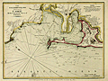 | Details | Laurie and Whittle | 1810 |
| Antique Chart of the Bay, Harbor, and Environs of Cadiz, Spain |
|
Laurie and Whittle |
|
| 1810 |
| LOC:4 |
| $275.00 | Laurie-and-Whittle | Antique-Chart-of-the-Bay--Harbor--and-Environs-of-Cadiz--Spain | Attractive nautical antique chart of the Bay of Cadiz, Spain published by British entrepreneurs Laurie and Whittle in 1810. Some of the key features noted in English include the settlements of Rota, Port Santa Maria, Port Royal ( Puerto Real ), Trocadero, St. Carlos Town and Cadiz, Spain. Other features include the Battery of la Gallina, Rio Salado, Castle of Santa Cataline, Convent of la Victoria, Bridge of Boats, Channel of Trocadero, and the Arsenal of the Carracas. On the Isle of Leon are located Torre Gorda or Hercules' Tower, Saint Carlos Town, Martyr's Hill, Castle of Puntales, Fort San Fernando, and the walled town of Cadiz itself with the Castle and Lighthouse of Saint Sebastian jutting westward into the Atlantic Ocean.
<br></br>
Notations of soundings, bottom composition, shoals and other navigational hazards would have made this chart useful to early 19th century sailors.
<br></br>
Publishers attribution at bottom reads: 'Published by Robert Laurie and James Whittle, Chart sellers to the Admiralty, &c &c. No. 53 Fleet Street, London. May 24, 1810.' This antique harbor plan / chart is an original copperplate engraving with later hand coloring based on the work of Spanish cartographer Tofino de San Miguel. Watermarked chain laid paper with the watermark date of 1805. |
| 4788 | 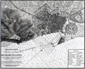 | Details | Direccion Hidrografia | 1813 |
| Rare Antique Plan of the Port and Anchorage at Barcelona, Spain |
|
Direccion Hidrografia |
|
| 1813 |
| LOC:88 |
| $600.00 | Direccion-Hidrografia | Rare-Antique-Plan-of-the-Port-and-Anchorage-at-Barcelona--Spain | Very interesting antique Spanish chart / port plan of Barcelona, Spain on the Mediterranean Sea. One of 16 charts and plans published by Spain's Direccion Hidrografia in the rare Spanish hydrographic atlas: "Portulano de las Costas de la Península de España, Islas adyacentes, y parte de la Costa de Africa. Construido y publicado en la Direccion Hidrografica, Cadiz ano 1813."
<br></br>
With (now faded) MS dedication and attached anchoring instructions, both in English. The dedication read "Presented by W??????? To his fd (friend?) Mr. Fleming Cadiz July 12, 1816." That date is 3 years after the atlas was first issued from Cadiz.
<br></br>
Scarce, no copy in AMPR
<br></br>
Included manuscript sailing directions reads
<div class="indenttextblock">
"In the outside Harbour of Barcelona to protect yourself of the E. and S.E. winds, anchor as follows= The light with the Tower of Merced and the coast of Garaf open on the south of Montjuif, anchoring in 18 - 25 f[athoms]mostly sand, from which … an east wind you can pass the Llobregat."
</div>
<BR/>
A circled spot on the map with light penciled isobaths (contour lines) at 10 and 20 fathoms seem to support the anchoring recommendation in the sailing directions.
<br></br>
Depth soundings are in "pies castellanos" ( 1 Castillian foot = .2786 m or .914 feet). |
| 144 |  | Details | Tardieu, Ambroise | 1818 |
| Plan du Combat Naval d'Algeciras |
|
Tardieu, Ambroise |
|
| 1818 |
| LOC:8 |
| $375.00 | Tardieu--Ambroise | Plan-du-Combat-Naval-d-Algeciras | A highly detailed, elegant, antique copperplate chart / map produced by Ambroise Tardieu (1788-1841) for Dumas' multi-volume "Precis Des Evenemens Militaires". The chart shows the positions of French, Spanish, and British ships during the battle of Algeciras set against a highly detailed hydrographic and topographic background. Careful and meticulous hachuring conveys elevation. Inset legend at bottom right explains labeled positions of ships including "le formidable vaisseaux General Francais" and "Chaloupes canonieres Espagnoles".
<BR> </BR>
Notation in upper right border: "Campagne de 1802. Tome 1.". |
| 2567 |  | Details | Anonymous | 1823 |
| Manuscript Plan of San Sebastian, Spain. Basque region |
|
Anonymous |
|
| 1823 |
| LOC:0 |
| $0.00 | Anonymous | Manuscript-Plan-of-San-Sebastian--Spain--Basque-region | SOLD
<BR> </BR>
Manuscript plan of San Sebastian, Spain a resort town on the Bay of Biscay.
<br></br>
Anonymous manuscript pen and ink plan of shows a well-fortified cape jutting into a body of water. Military orientation and focus. Much small fine detail. Many important places are numbered but no legend is present. French text.
<br></br>
A structure overlooks a fortified town, several batteries, and a small protected harbor. In text is the obscured author's name beginning with letter "P", date "1823", the scale "1/5000". The three identified location descriptions read "Redoute du Rondeau" and "Batterie St. Elme" and "Aqueduc". |
| 539 |  | Details | Donnet, Alejo | 1831 |
| Algarbe, Andalucia, Granada |
|
Donnet, Alejo |
|
| 1831 |
| LOC:0 |
| $575.00 | Donnet--Alejo | Algarbe--Andalucia--Granada | Map of the Algarve region in Portugal, southwest Spain, and the Strait of Gibraltar, with numerous city insets: Seville, Merida, Tarifa, Murviedro, Cadiz, Algeciras and Gibraltar. Large, attractive, well-kept, linen-backed folding map has been dissected into 18 sections of about 5.5 x 7.5 inches when issued. <BR> </BR>
The map's source is Donnet's six-sheet "Mapa Civil y Militar de España y Portugal, con la nueva división en distritos." Shows the Portuguese and Spanish coasts from Cape St. Vincent to well past Malaga along with the North African coast, Strait of Gibraltar, and Mediterranean Sea. Political regions and divisions are outlined in red. Published by Dauty and sold by Simonneau ca. 1831 from Paris. Hoja 4. <BR> </BR>
Contains two altitudinal cross sections. Detailed insets of key cities with prominent points identified and tied to a key for each city.<BR> </BR>
The map is unusual in that it presents 11 different measurement scales in alignment:<BR>
Leguas Geograficas de Espana<BR>
Leguas Legales de Espana<BR>
Leguas de Aragon<BR>
Leguas de Mallorquinas<BR>
Leguas Municipales Valencianas<BR>
Legoas communes de Portugal<BR>
Leguas Marimas o de 1 hora de Camino<BR>
Myriametres 10 por un grado decimal<BR>
Lieues de Poste de France 2000 toises<BR>
Lieues communes de France 2285 toises<BR>
British miles 1760 yards<BR> </BR>
Cover contains the seller's label in very fine condition that reads:<br>
"Magasin de Geographie de Charles Simonneau Graveur.
A Paris, Rue de la Paix, No. 6. Hotel Mirabeau vis-à-vis le Timbre. <br>
Cartes Geographiques et Topographiques Francaises et Etrangeres.<br>
Globes, Spheres, Atlas. Geographie, Ancienne et Moderne.<br>
(In manuscript): Espagne & Portugal Sud Ouest."<BR> </BR>
Not dated but Charles Simonneau was a French engraver, map publisher, and map seller in Paris, France from approximately 1803 to 1838. Grave par les Freres Malo, Rue du Ges No. 10. Pres la Sorbonne. |
| 540 |  | Details | Donnet, Alejo | 1831 |
| Cuenca, Valencia, Murcia, Baleares |
|
Donnet, Alejo |
|
| 1831 |
| LOC:0 |
| $550.00 | Donnet--Alejo | Cuenca--Valencia--Murcia--Baleares | Antique map of the Balearic Islands: Ibiza, Formentera, Mallorca ( Majorca ), Menorca ( Minorca ); the Mediterranean Sea, and the East coast and interior of Spain. Published by Dauty and sold by Simonneau from Paris ca. 1831. Title printed on the map reads: "Cuenca, Valencia, Murcia, Baleares". The map's source is Donnet's six-sheet "Mapa Civil y Militar de España y Portugal, con la nueva división en distritos."
<BR> </BR>
Large, attractive, well-kept, linen-backed folding map dissected into 18 sections of about 5.5 x 7.5 inches as issued. Maps the Balearic Islands and the East coast of Spain from Mar Menor near Cartagena north to Barcelona. Political regions and divisions are outlined in red. <BR> </BR>
Cover contains the seller's label in very fine condition that reads:<br>
"Magasin de Geographie de Charles Simonneau Graveur.
A Paris, Rue de la Paix, No. 6. Hotel Mirabeau vis-à-vis le Timbre. <br>
Cartes Geographiques et Topographiques Francaises et Etrangeres.<br>
Globes, Spheres, Atlas. Geographie, Ancienne et Moderne.<br>
(In manuscript): "Espagne (illegible) centrales."<BR> </BR>
Not dated but Charles Simonneau was a French engraver, map publisher, and map seller in Paris, France from approximately 1803 to 1838. Engraving is attributed as: "Grave par les Freres Malo, Rue du Gres No. 10. Pres la Sorbonne." Contains index tab at top of the map: "No. 4". |
| 541 |  | Details | Donnet, Alejo | 1831 |
| Suplemento a los Planos de Ciudades |
|
Donnet, Alejo |
|
| 1831 |
| LOC:2001 |
| $500.00 | Donnet--Alejo | Suplemento-a-los-Planos-de-Ciudades | Scarce, detailed, antique folding map of plans for key cities in Spain and Portugal: Barcelona (still surrounded by a fortified wall), Ciudad Rodrigo, Tortosa, Oviedo, Denia, Cadiz, Granada, Lisbon (Lisboa), Madrid, Cartagena, and Valencia. The map was published as a supplement to Donnet's six-sheet "Mapa Civil y Militar de España y Portugal, con la nueva división en distritos."
<BR> </BR>
Large, attractive, well-kept, and linen-backed. Dissected into 18 sections of about 5.5 x 7.5 inches as issued. Published by Dauty and sold by Simonneau from Paris ca. 1831. The map is identified at top as the seventh and last part. <BR> </BR>
Cover contains the seller's label in very fine condition that reads:<br>
"Magasin de Geographie de Charles Simonneau Graveur.
A Paris, Rue de la Paix, No. 6. Hotel Mirabeau vis-à-vis le Timbre. <br>
Cartes Geographiques et Topographiques Francaises et Etrangeres.<br>
Globes, Spheres, Atlas. Geographie, Ancienne et Moderne.
With an index tab at top of the folded maps that reads: "Plans des Villes"<BR> </BR>
Not dated but Charles Simonneau was a French engraver, map publisher, and map seller in Paris, France from approximately 1803 to 1838. Attribution at bottom reads: " A Paris. Chez Dauty et Demaisons Palais Royal Galerie de Nemours, et Malo aine Graveur Rue St. Jacques No. 169." |
| 5351 |  | Details | City of Tarragona | 1833 |
| Very rare antique port pass for Tarragona, Spain wine related with map |
|
City of Tarragona |
|
| 1833 |
| LOC:57 |
| $900.00 | City-of-Tarragona | Very-rare-antique-port-pass-for-Tarragona--Spain-wine-related-with-map | Handsome, finely engraved, signed antique ship's port pass and anchorage plan for the U.S. Brigantine "Hancock" at the port of Tarragona, Spain along the Mediterranean Sea. The port pass, dated within at 1833, includes a large anchorage plan with numerous soundings for the port for Tarragona, with sailing directions in three languages [1] and a description of the ship's cargo of wine and aguardiente. Spanish text.
<br></br>
Rare. No holdings of this item are listed in WorldCat and only one record of a sale of a similar document, from 1820.
<br></br>
Bearing the armorial seal of Tarragona, Spain, the document is topped with a view of the walled city of Tarragona below a Latin scroll touting the safety and health of "Tarraco" [2]. At bottom the signers specify the pass applies specifically to the United States Bergantine (Brig) Hancok (Hancock ?), captained by Ebenezer L. Higgins [3], with a crew of eight sailors. Dated to February 12, 1833 the pass specifies the cargo exported from Tarragona to Brazil consisted of "vino tinto" (red wine), "aguardiente refinado" (brandy) and "aguardiente anisado" (an anise-flavored liqueur popular today in Colombia) [4].
<br></br>
SOURCES:
<br>
[1] "Cape Salou bears from the point of the mole to the So[luth] 5° O. 7 miles distant & Cape Gros or Pointe de la Mora to the east 12° 30' N. 6 1/2 miles distant. The soundings are denoted in Spanish feet of which 35 make 32 English feet." <br>
[2] "Salutem et Sanitatem en Capite insigni Despectans Tarraco Pontum." <br>
[3] Possibly Captain Ebenezer Higgins of Provincetown, Mass. (b. 1807) who died at the helm of the schooner Been Atkins on June 8, 1846 while bound for Norfolk, Virginia. (https://www.findagrave.com/memorial/120392629/ebenezer-higgins) <br>
[4] Colome-Ferrer, Josep and Ferrer, Loren. The importance of the liquor sector in Catalan viticulture in the 18th and 19th centuries. (From Spanish) Journal of Industrial History. No. 79. 2020. |
| 213 |  | Details | Norie, J.W. | 1845 |
| Sailing Directions for the Coasts of Spain and Portugal |
|
Norie, J.W. |
|
| 1845 |
| LOC:0 |
| $0.00 | Norie--J-W- | Sailing-Directions-for-the-Coasts-of-Spain-and-Portugal | SOLD<br></br>
Small scarce 42 page booklet of sailing directions for the West coasts of Spain and Portugal compiled by J.W. Norie and published by Charles Wilson in 1845. Paper covers. Fascinating reading. With one and one half pages plus rear cover listing charts for sale with prices. Front cover contains signature of Sewell Strout, quite possibly Sewell Cushing Strout of Bridgton, Maine who served as an Associate Justice on the Maine Supreme Court (d. 1914). |
| 762 | 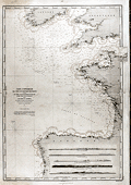 | Details | Depot de la Marine | 1878 |
| Antique French Nautical Chart of Spain, Ireland and England |
|
Depot de la Marine |
|
| 1878 |
| LOC:0 |
| $0.00 | Depot-de-la-Marine | Antique-French-Nautical-Chart-of-Spain--Ireland-and-England | SOLD
<br></br>
Antique navigation chart covering the approaches along the south and west coasts of Spain, Cornwall England and Southern Ireland. Includes the Gulf of Gascogne; the English Channel northeast to Chichester and le Harve; and the Irish Sea. This large chart is unusual in that it shows all the numerous lighthouses along those coastlines and through red overprinting shows for each light the expected range over which that light should be visible from sea. Lighthouses are shown as red dots with yellow highlights.
<br></br>
Inset at bottom shows five profile coastal views. Chart is the edition of 1867, first published in 1828 and 1829. This edition was updated last in 1878. Number 447. Published by France's Depot de la Marine. |
| 4792 | 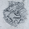 | Details | British Admiralty Hydrographical Office | 1899 |
| Antique British Chart of Gran Canaria island |
|
British Admiralty Hydrographical Office |
|
| 1899 |
| LOC:54 |
| $275.00 | British-Admiralty-Hydrographical-Office | Antique-British-Chart-of-Gran-Canaria-island | Antique, used 1899 British Admiralty nautical chart of the island of Gran Canaria one of the Canary Islands of Spain, lying off the coast of northwest Africa. In 1900 the population of the entire group of Canary Islands was estimated at almost 360,000 individuals with the main exports consisting of wine, spirits, potatoes, tobacco, bananas, and cochineal.
<br></br>
Based on a survey by Lieutenant William Arlett (d. 1839) of the Royal Navy aboard the ship Aetna. With several manuscript notations and course plots in pencil, attesting to a well-used life aboard ship. Arlett's notes on his survey of the Canary Islands describes his impression of the island and the survey method of triangulation, employed across the entire island :<div class="indenttextblock">
"On the 14th December we arrived at Port la Luz in the island of La Gran Canaria, the Great Canary. This island is nearly circular and about twenty-four miles in diameter, or seventy-five in circumference. Its is mountainous, and the coast, gereally speaking, precipitous. "
…<br></br>
"A base having been measured, a triangulation was carried completely round the island, whence the soundings as well as the coast line were laid down trigonometrically.
" (Arlett, W. The Journal of the Royal Geographic Society of London. Volume 6. 1836.)</div>
<BR/>
Highly detailed topography in the interior of the island. Includes these key features: Las Palmas, the capital city; la Luz Harbor; Ayrenaga Bay; Tenefe Point; Romeral Castle (Castillo); and Morro Colchas point with its lighthouse. With an inset plan of Maspalomas Anchorage and two inset coastal elevation views. Lighthouses are highlighted in yellow.
<br></br>
The chart was first published at the Admiralty in London on June 26th, 1848. Sold by J.D. Potter, agent for sale of Admiralty Charts, 14-5 Minories. Verso with MS chart collation number "5b". Number 1869. Numerous large and small corrections, the last correction in 1899. |
| 4858 | 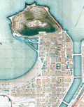 | Details | Garcia, G. | 1919 |
| Guide to San Sebastian, Spain |
|
Garcia, G. |
|
| 1919 |
| LOC:88 |
| $150.00 | Garcia--G- | Guide-to-San-Sebastian--Spain | Small folding brochure for San Sebastian, Spain aimed at travelers. Edited by Miguel Ramos . July, 1919.
<br></br>
Contains one folding lithographed map (by G. Garcia) and about 12 dual sided pages of advertisements. Legends for key streets and locations. One of the brochure pages is a fine steel engraving of an eagle perched upon a wreath. Within the wreath the printers acknowledgement:
<div class="indenttextblocksingle">
"Esta guia esta impresa en los talleres tipo-litograficos de la Editorial Guipuzcoana. Muguerza Hos. Y Yarza: Tolosa."
</div> |
| 1133 | 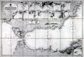 | Details | British Admiralty Hydrographical Office | 1925 |
| Old nautical chart of the west Mediterranean Sea |
|
British Admiralty Hydrographical Office |
|
| 1925 |
| LOC:0 |
| $0.00 | British-Admiralty-Hydrographical-Office | Old-nautical-chart-of-the-west-Mediterranean-Sea | SOLD
<br></br>
A fine folding British sea chart of the western Mediterranean sea. Based on a chart originally published at the Admiralty in 1878 under the superintendence of Captain F.J. Evans.
<br></br>
This handsome chart provides numerous depth soundings, lighthouse locations, coastal details, and other hydrographic information for the Mediterranean coastline of Spain, Morocco, and Algeria including the important Strait of Gibraltar.
<br></br>
Eighteen inset port and anchorage plans including:
<div class="indenttextblock">
<ul style="list-style-type: circle;">
<li>Salobrena Anchorage</li>
<li>Cala Honda</li>
<li>Ferro Castle Anchorage</li>
<li>Adra Anchorage</li>
<li>Almeria Road</li>
<li>Cape de Gata</li>
<li>Port Genoves and San Jose Bay</li>
<li>San Pedro Bay</li>
<li>Carboneras Bay</li>
<li>Port Aguilas</li>
<li>Cope Anchorage</li>
<li>Mazarron and Surida Bays</li>
<li>Porman Bay</li>
<li>Escuellos Bay</li>
<li>Nerja Anchorage</li>
<li>Herradura Bay</li>
<li>Berenguelas Bay</li>
<li>Alboran Island</li>
</ul>
</div>
Dissected and laid to fine linen. Early 20th century edition with numerous corrections, the last in correction in 1925. Sellers label on the verso for Sifton, Praed, & Co. Ltd. The Map House. 67 St. James Street, London S.W. Owners ink stamp on cover "H.F. Cronin." Marbled board covers. Number 2717. |
| 899 | 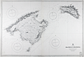 | Details | British Admiralty Hydrographical Office | 1930 |
| Balearic Islands of Majorca and Minorca |
|
British Admiralty Hydrographical Office |
|
| 1930 |
| LOC:0 |
| $0.00 | British-Admiralty-Hydrographical-Office | Balearic-Islands-of-Majorca-and-Minorca | SOLD<br></br>
Bold, authentic British sea chart of two of Spain's Balearic Islands: Majorca (Mallorca) and Minorca (Menorca). In excellent condition. Originally engraved and published in 1897 from London by the Admiralty under the superintendence of Rear Admiral W.J.L. Wharton. Lighthouses and other navigational aids are hand colored in yellow. This large chart will make a very attractive, unusual, and affordable gift for anyone with an interest in fishing or boating in the vicinity of Mallorca or Menorca in the Mediterranean Sea. Thousands of depth soundings, numerous bays, headlands, and villages pack this old pre-war nautical chart. Key habitations include Palma, Pollensa, Arta, Manacor, and Santany, Mallorca.
<br></br>
This version of the Balearic Island chart dates to 1930 when it was published with corrections. This bold dark lithographed print retains the sharp cartographic look and style of the late 19th century. More recent charts do not display the character of this beauty. Logo of the British Hydrographical Office at top of the title block. Number 1317. Sold by J. D. Potter, 145 Minories. |
| 5079 | 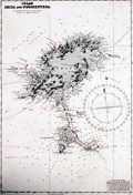 | Details | British Admiralty Hydrographical Office | 1973 |
| Plans in the Islas Baleares from Spanish Government Charts |
|
British Admiralty Hydrographical Office |
|
| 1973 |
| LOC:58 |
| $175.00 | British-Admiralty-Hydrographical-Office | Plans-in-the-Islas-Baleares-from-Spanish-Government-Charts | Plans of the islands Ibiza and Formentera in Spain's Mediterranean Balearic Islands. Engraved in 1902 and published from London in July 8, 1902 by the British Admiralty under the superintendence of Captain W. J. L. Wharton, Hydrographer. Charts are after the Spanish Government Charts, 1898 - 1900. This sheet with corrections to 1973.
<br></br>
Includes the Balearic Islands of Ibiza and Formentera at a scale of 1 / 195,000 and the channel between Ibiza and Espalmador at a scale of 1 / 36,420
<br></br>
Chart number 3276. Crown Copyright Reserved. |