| | Thumbnail | | Creator | Date | Title / Author / Date / Location | Price | | | Description |
| 753 | 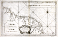 | Details | Depot de la Marine | 1760 |
| Antique French sea chart of South America south of the Orinoco River |
|
Depot de la Marine |
|
| 1760 |
| LOC:67 |
| $475.00 | Depot-de-la-Marine | Antique-French-sea-chart-of-South-America-south-of-the-Orinoco-River | Original, 254 year-old antique working nautical chart of the east coast of South America including parts of Venezuela, Guyana, Suriname, French Guiana and Brazil. Coverage on this large French sea-chart includes a large area between the Orinoco (Grande Embouchure de l'Orenoque) and Amazon rivers that was once collectively known as "Guyane", a term derived from an indigenous word meaning "land of many waters". Named geographical features include Nouvelle Middelbourg, Fort de Nouvelle Zeeland, Cap de Nassau, Essequibo River, a settlement along the Essequibo labeled simply "le Bourg", Demerary River, Berbiche River, Port Nassau, Corentin River, Suriname River, Paramaribo and Nouvelle Amsterdam, Maurany River, Devils' Islands (Isles au Diable), Oyapoque River, Counany River, Cayenne, St. Paul Mission, Cap d'Orange, and Cap de Nord.
<br></br>
Numerous depth soundings, anchorages, hazards, and offshore details are noted. Some interior detail including rudimentary roads, missions, and guard posts are shown in French Guiana.
<br></br>
As denoted on the chart coverage area extends southward from Venezuela (Guyane Espagnole), Guyana and Suriname (Guyane Hollandoise) to French Guiana (Guyane Francoise) and Brazil (Guyane Portugaise). Inset at top right contains a elevation plan of the coast in the vicinity of Cayenne, the capital of French Guiana. Inset at bottom left contains profiles of headlands seen when approaching Cayenne and Cap d'Orange from the sea.
<br></br>
By Nicolas Bellin in 1760, working for France's Depot des Cartes et Plans de la Marine. At this later stage of his career Bellin's extensive experience as a cartographer is evidenced by the attribution within the large decorative cartouche: "Par le S, Bellin Ingenieur de la Marine, Censeur Royal de l'Academie de Marine, et de la Societe Royal de Londres."
<br></br>
With the circular anchor logo of the Depot de la Marine. |
| 624 | 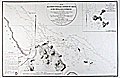 | Details | Depot de la Marine | 1822 |
| Mouth of Cayenne River, French Guiana and Anchorages |
|
Depot de la Marine |
|
| 1822 |
| LOC:0 |
| $0.00 | Depot-de-la-Marine | Mouth-of-Cayenne-River--French-Guiana-and-Anchorages | SOLD <br></br>
Large antique nautical chart of the mouth of the Cayenne River, the town of Cayenne, French Guiana and the surrounding coastline and offshore environs. Coverage centers on the island and town of Cayenne with numerous soundings and some hachured topographical relief. This excellent original copper-plate engraved sea chart includes the mouths of the Mahury and Cayenne Rivers, Mt. Cabasson, Mt. des Tigres, Mt. Dupont, Mt. de Mahury, Rentontabo, Pointe du Diamant ( Diamond Point ), and the islands of Malingre, Le Pere, La Mere, and Les Mamelles, and alone about 5 miles offshore, L'Enfant Perdue (Lost Child ). <br></br>
Issued by the French Depot de la Marine and containing the circular mark of that body at lower left within an "Avertissement" containing sailing directions. Engraved by Ambroise Tardieu.<br></br>
Inset at upper right of the "Plan des Isles du Salut", a French penal colony in the mid 19th century. Features Ile du Diable, Ile St. Joseph, and Ile Royale. Of these Ile du Diable is the infamous Devil's Island, designated for political prisoners and featured in the 20th century film 'Papillion', starring Steve McQueen and Dustin Hoffman. No 199 with a later stamp "29" in red. Dated within oval cartouche to 1822. |