| | Thumbnail | | Creator | Date | Title / Author / Date / Location | Price | | | Description |
| 8053 | 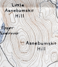 | Details | Appalachian Mountain Club | 1891 |
| Map of the Country About Worcester Compiled by Appalachian Mountain Club |
|
Appalachian Mountain Club |
|
| 1891 |
| LOC: |
| $1,100.00 | Appalachian-Mountain-Club | Map-of-the-Country-About-Worcester-Compiled-by-Appalachian-Mountain-Club | A scarce regional map of central Massachusetts titled <i>Map of the Country About Worcester</i>, published in 1891 by the Appalachian Mountain Club. The map is a sister publication to the Club’s <i>Map of the Country About Boston</i>, issued a year earlier in 1890, and extends AMC coverage westward from the Boston basin into the uplands and river valleys of interior Massachusetts. Only six institutional holdings are recorded in WorldCat, underscoring the map’s scarcity.<br><br>
The maps were compiled from multiple U.S. Geological Survey quadrangle sheets and reduced to a uniform scale. Together, the two sheets extend the Appalachian Mountain Club’s regional mapping beyond the Boston basin into central Massachusetts. Their production reflects the Appalachian Mountain Club’s effort to adapt official government mapping into practical regional maps suitable for recreational, educational, and reference use.<br><br>
The Worcester map appeared in 1891, the same year that <i>The Trustees of Public Reservations</i> was founded, marking a pivotal moment in Massachusetts conservation history. Both initiatives were closely associated with Charles Eliot, an early member of the Appalachian Mountain Club who became its Councilor of Topography in 1890 and was a leading advocate for systematic landscape preservation.<br><br>
As stated in the imprint, the map was “Published by the Appalachian Mountain Club from the proofs of the State map with the permission of the director of the United States Geological Survey and the Commissioners of the Topographic Survey of Massachusetts.” The sheet was lithographed by George S. Harris and Sons, with sales agents W. B. Clarke and Company of Boston and Putnam and Davis, Booksellers, Worcester. |
| 8047 | 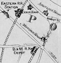 | Details | Little, N. Jr. | 1875 |
| Map of mining lands at Newbury, near Newburyport, Essex County, Massachusetts |
|
Little, N. Jr. |
|
| 1875 |
| LOC:41 |
| $950.00 | Little--N--Jr- | Map-of-mining-lands-at-Newbury--near-Newburyport--Essex-County--Massachusetts | An original late 19th century survey map titled "Map of Mining Lands at Newbury, Near Newburyport, Essex County, Massachusetts", formally entered according to Act of Congress in 1875. Issued separately in a small covered booklet. Drawn by N. Little Jr., the sheet presents a large-scale depiction of the marshlands, waterways, and adjoining uplands of the lower Merrimack and Parker River region. Not much is known about Little but several parcels of land on the map are attributed to N. Little Jr. making the author a very interested stakeholder in the maps' creation and publication.
<br><br>
Executed at a scale of 125 rods to one inch, the map delivers a level of practical detail associated with cadastral and engineering surveys rather than general town mapping. A decorative compass rose anchors the composition at left, while clearly defined town boundaries identify West Newbury, Newbury, Rowley, and Georgetown, with Newburyport situated prominently along the Merrimack River corridor.<br><br>
The map is especially informative in its integration of natural geography, transportation infrastructure, and parcel-level land division. The Merrimack River spans the upper portion of the sheet with the Newbury Flats labeled along the riverfront, while the eastern extent reaches to the Plum Island River, Plum Island, and the Atlantic Ocean, including Salisbury Beach. The Parker River winds through the lower right quadrant, fed by numerous named creeks and surrounded by finely stippled marshland drainage. Two railroad lines, the Eastern Railroad and the Boston and Maine Railroad, are clearly drawn and labeled, reinforcing the economic context of the survey. Throughout the central and southwestern areas, dense subdivision lines and owner-name annotations document individual parcels within the designated mining lands, confirming the map’s function as a legal and developmental instrument rather than a purely descriptive view of the region.<br><br> |
| 6833 |  | Details | Van Ingen, Snyder, Gillett | 1876 |
| Pictorial Map of the International Exhibition Grounds First U.S. Worlds Fair |
|
Van Ingen, Snyder, Gillett |
|
| 1876 |
| LOC:86 |
| $975.00 | Van-Ingen--Snyder--Gillett | Pictorial-Map-of-the-International-Exhibition-Grounds-First-U-S--Worlds-Fair | Unrecorded variant edition "Pictorial Map of the International Exhibition Grounds", the first "World's Fair" held in the United States (1876) the same year the Statue of Liberty began construction in France. Along with the technological innovations and displays of American natural resources the Centennial Exhibition is notable as the location where two works of the renowned sculptor Frederic Auguste Bartholdi were on display- the right hand and torch of the Statue of Liberty and the Bartholdi Fountain.
<br><br>
<div class="indenttextblocksingle">
"In May of 1876, Bartholdi constructed the right arm bearing the torch, realizing it could stand alone if financing for the entire project failed. The torch’s display at the Centennial Exhibition in Philadelphia from August to November 1876 was a definite highlight with the fair’s approximately ten million visitors. Many scaled the 42-foot tall display for a fee of 50 cents."
</div><br> |
| 7932 |  | Details | Kenyon Company | 1924 |
| Bankers Life Radio Map of the United States |
|
Kenyon Company |
|
| 1924 |
| LOC:41 |
| $300.00 | Kenyon-Company | Bankers-Life-Radio-Map-of-the-United-States | In 1924, American broadcasting was new enough to map. This Radio Map of the United States, engraved and published by the Kenyon Company of Des Moines with compliments of the Bankers Life Company, plots cities through their call signs. It is a document from the first radio boom, two years before the major networks formed, when individual stations defined the medium and listeners learned the geography of the air by call letters alone.
<br><br>
The design is simple and utilitarian. Time zone lines and numbered radio districts divide the country. Cities host their stations without decorative effects. The emphasis is informational: where a station is, what it is called, and how federal administration overlays the national map.
<br><br>
As advertising, the piece is direct. Bankers Life, calling itself the largest life insurer west of the Mississippi, links its presence to the spread of broadcasting. The sober printing and neat index give the map the tone of a directory while keeping the sponsor in view.
<br><br>
The call letters also tell a regulatory story. After 1912 the United States used the leading letters K, W, N, and A. For broadcasting, officials split K and W geographically and finalized the Mississippi River divide in 1923. New stations west of the river took K, those east took W, but early assignees kept their calls. That is why KDKA and KQV appear in Pittsburgh, east of the line. The 1924 sheet shows the new rule with the older exceptions still present.
<br><br>
A partial list of stations include:
<br><br> |
| 6835 | 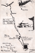 | Details | Yenching University Geology Department | 1927 |
| Rare Advertising Brochure Map of Peking for Sanitary Fur Company |
|
Yenching University Geology Department |
|
| 1927 |
| LOC:41 |
| $320.00 | Yenching-University-Geology-Department | Rare-Advertising-Brochure-Map-of-Peking-for-Sanitary-Fur-Company | Rare, unrecorded pictorial advertising map of Peking or Beijing, China prepared ca. 1927 for the Sanitary Fur Company by the Department of Geology and Geography at Yenching University. The maps are signed by George Barbour (1). Format: small tourist-oriented folding brochure.
<br><br>
The interior of the brochure shows a two-panel "Simplified Map of Peking". Back panel with a smaller-scale "Plan of the Northern Environs of Peking."
<br><br>
According to an inserted sheet found within:
<div class="indenttextblocksingle">
"The tanning of furs in China was started by Dr. H. S. Vincent, head of the Leather Department of Yenching University. This much needed step has popularized Chinese furs as the tanning makes them perfectly sanitary, all germs being killed in the process which also destroys the disagreeable smell so noticeable with Chinese furs imperfectly tanned."
</div><br>
<div id="SC_6835" align="center">
<a title=""></a>
<img id="6835" src="/ZoomifyImages/SC_6835/SC_6835_detail.jpg" alt="Advertisement for the Sanitary Fur Company. Peking China. 1927." width="300"/> <br><font size="-2">Advertisement for the Sanitary Fur Company. 1927.</font>
</div><br> |
| 6755 |  | Details | Oppenlander, J. H. and H. F. | 1924 |
| Fine and rare map of the Columbia River Portland to the Dalles |
|
Oppenlander, J. H. and H. F. |
|
| 1924 |
| LOC:400 |
| $2,000.00 | Oppenlander--J--H--and-H--F- | Fine-and-rare-map-of-the-Columbia-River-Portland-to-the-Dalles | A very fine and very long (67") folding map of the Columbia River from Portland to the Dalles, Oregon- a straight-line distance of approximately 71 miles as the Google flies. North oriented to the left. Legend at far left end.
<br><br>
<div id="0" align="center">
<a title=""></a>
<img id="6755_1" src="/ZoomifyImages/SC_6755/SC_6755_Detail_1.jpg" alt="Detail of Portland, Oregon region from the Oppenlanders' 1924 map of the Columbia River." width="340"/> <br><br> <font size="-2">Portland, Oregon detail.</font>
</div><br>
As a collector, beyond all the hachured topography and meticulous colored detail, the map highlights are the numerous Lewis and Clark native-American place names, camps locations, and notes overlaid on the Oppenlanders' 1924 plan of the area.
<br><br>
<div id="0" align="center">
<a title=""></a>
<img id="6755_3" src="/ZoomifyImages/SC_6755/SC_6755_Detail_3.jpg" alt="Detail of Dalles region from Oppenlander's map of the Columbia River, 1924." width="340"/> <br><br> <font size="-2">The Dalles region detail, 1924.</font>
</div><br>
The map is carefully folded into a thirty-nine page booklet with text and photographs. From the Penland Guide Series' "The Columbia River Guide and Panorama- from Portland to the Dalles. Myths Legends - History- Geology - Lewis and Clark Notations - Vancouver Expedition Notes". Copyright 1924 by J. H. and H. F. Oppenlander, Portland, Oregon.
<br><br>
<div id="0" align="center">
<a title=""></a>
<img id="6755_2" src="/ZoomifyImages/SC_6755/SC_6755_Detail_2.jpg" alt="Panoramic photo looking east from Crown Point. Taken from Oppenlander's map of the Columbia River, 1924." width="340"/> <br><br> <font size="-2">Looking East from Crown Point.</font>
</div>
<br><br>
Six institutional holdings are noted in WorldCat (Washington and Oregon) but apparently quite rare on the market. |
| 6736 | 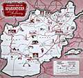 | Details | Information Bureau Royal Afghan Embassy London | 1960 |
| Rare Pictorial tourist map of Afghanistan |
|
Information Bureau Royal Afghan Embassy London |
|
| 1960 |
| LOC:54 |
| $475.00 | Information-Bureau-Royal-Afghan-Embassy-London | Rare-Pictorial-tourist-map-of-Afghanistan | A serious (not comical) pictorial map of Afghanistan published in the early 1960's by the Information Bureau of the Royal Afghan Embassy in London.
<br><br>
Rare, only one copy in WorldCat, at the University of Nebraska, Omaha.
<br><br>
Map focuses on mosques, livestock, and natural resources of Afghanistan. Boundaries of provinces delineated with dotted lines, and mountain passes shown by reversed brackets. Small inset map of Wakhan and Pamir. Scale 1:2,000,000. Roads with distances between major cities. |
| 6669 |  | Details | Empire Tours Accociation | 1913 |
| 1915 Empire Tours map Native American Adirondack Iroquois and Onondaga Trails |
|
Empire Tours Accociation |
|
| 1913 |
| LOC:86 |
| $100.00 | Empire-Tours-Accociation | 1915-Empire-Tours-map-Native-American-Adirondack-Iroquois-and-Onondaga-Trails | Empire Tours thematic tours map issued by the Empire Tours Association in 1913. Map shows three colored auto-tourism routes in New York State: the Adirondack Trail, Iroquois Trail, and Onondaga Trail all routes associated with Native American tribes and. Numbers opposite the tour routes referred to corresponding route numbers in Volume 1 of the Automobile Blue Book.
<br><br>
Copyright Empire Tours Association. Compiled by Official Automobile Blue Book Publishing Company. Comprises eight panels of a 12-panel brochure.
<br><br>
Overall, the Empire Tours map issued by the Empire Tours Association in 1913 provides a fascinating glimpse into the early days of auto tourism in New York and the United States, and highlights the important role that organizations like the Empire Tours Association played in promoting travel and tourism in the region.
<br><br>
During the early 20th century, the advent of the automobile brought about a new era of travel and exploration, as more and more people began to hit the road in search of adventure and new experiences. To help these travelers navigate the often-unfamiliar territory they encountered on their journeys, publishers began producing auto tour road maps, which provided detailed information about road conditions, landmarks, and other useful information.
<br><br>
Circa 1910-1920, these road maps were an essential tool for any auto tourist, as they helped drivers plan their routes, find accommodations, and locate important sites and attractions along the way. Many of these maps were produced by established publishers, such as the Official Automobile Blue Book Publishing Company and Rand McNally, and featured colorful illustrations, detailed descriptions, and helpful tips for travelers.
<br><br> |
| 6648 |  | Details | Seaboard Air Line Railway | 1917 |
| Military Camps Winter Resorts Map Florida |
|
Seaboard Air Line Railway |
|
| 1917 |
| LOC:150 |
| $800.00 | Seaboard-Air-Line-Railway | Military-Camps-Winter-Resorts-Map-Florida | Rare patriotic WWI map titled "Military Camps and Nearby Resorts. Winter Near Your Soldier Boy." This fine 31 inch long antique map was published by Seaboard Airline Railway in 1917. Outstanding and emotionally evocative graphics on the cover with a fine thematic promotional map on the recto.
<br><br>
<div id="0" align="center">
<a title=""></a>
<img id="6648" src="/ZoomifyImages/SC_6648/SC_6648_cover_detail.jpg" alt="WWI map titled "Military Camps and Nearby Resorts. Winter Near Your Soldier Boy" published by Seaboard Airline Railway Florida." width="100"/> <br><br> <font size="-2">Military Resorts Cover Art</font>
</div><br>
Only one holding is found in WorldCat, at Rutgers. WorldCat's mildly cynical one-line summary of the map reads <b>"War as a tourist industry for elegant ladies & gentlemen."</b> (1)
<br><br>
This full-size folding map shows twenty-eight locations (Army, Navy, and Aero training camps) served by the Seaboard Air Line Railway where a spouse (wife) could travel to spend the winter holidays with her soldier (husband) during 1917, the fourth year of WWI. The camps and stations of the U.S. Army were indicated with red square symbols, those of the Navy with circles, and Aero Stations by triangles. The U.S. Army Air Service, as it was then called, was established after April, 1917 making this map one of the earliest available maps to show Pensacola as an Naval Air Training Station.
<br></br>
These Army, Navy, and Aero training locations, described in the key at bottom right, include Pensacola, Tampa, and Key West, Florida; New Orleans, Louisiana; Charleston, South Carolina; and Port Royal, SC.
<br></br>
Brochure folds to 4" x 9". Printed by Poole Brothers, Chicago and dated within at 8/16/1917.
<br><br>
(1) WorldCat. Online. Accessed: January, 2023 |
| 6451 | 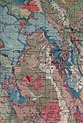 | Details | U.S. Geological Survey | 1935 |
| Fine large Geologic Map of Colorado |
|
U.S. Geological Survey |
|
| 1935 |
| LOC: |
| $500.00 | U-S--Geological-Survey | Fine-large-Geologic-Map-of-Colorado | Original large folding Geologic Survey Map of Colorado [1] from 1935, dissected and laid to linen. With an inset index map of Colorado. Includes an impressive table of the principal sources of geologic data that were used to compile the map of Colorado, USA. Published by the Department of the Interior, U.S. Geological Survey.
<br><br>
Scarce in this format. Type of rock (igneous, metamorphic, sedimentary) is indicated by color keyed to an extensive index scattered across the right side of the map.<br><br>
[1] Geologic Map of Colorado by the United States Geological Survey W. C. Mendenhall Director in cooperation with the Colorado State Geological Survey Board and Colorado Metal Mining Fund 1935. |
| 5108 | 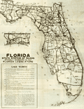 | Details | Lake Worth Herald Press | 1928 |
| 1927 Florida State Road Map |
|
Lake Worth Herald Press |
|
| 1928 |
| LOC:87 |
| $125.00 | Lake-Worth-Herald-Press | 1927-Florida-State-Road-Map | Road map for the entire state of Florida in a ten-panel folding brochure published during the 1920's Florida land boom, prior to the Great Depression. The brochure is titled: "Greeting Nobles, Oases of Lake Worth welcomes you. This road guide will assist you in your tour of Florida while attending the Shrine Convention at Miami, May 1, 2, 3, 1928."
<br></br>
Cover with logo for the Shriner organization. Verso captioned "Lake Worth Greets You" and filled with text descriptions and half-tone photographs of Lake Worth's attractions including the Municipal Recreational Center, the Gulf Stream Hotel, and its fine schools.
<br></br>
Published by the Lake Worth Herald Press. |
| 5109 | 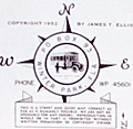 | Details | Winter Park Board of Realtors | 1951 |
| Mid-century map of Winter Park Florida |
|
Winter Park Board of Realtors |
|
| 1951 |
| LOC:87 |
| $115.00 | Winter-Park-Board-of-Realtors | Mid-century-map-of-Winter-Park-Florida | Map of the city of Winter Park, Florida and vicinity published by the Winter Park Board of Realtors (1952) in a 12-panel folding format. Lakes shown boldly in green. Key at bottom left with road reference locations in Orlando, Eatonville, Maitland, and Winter Park. One section of road highlighted in red. Small manuscript notation in pencil.
<br></br>
Verso titled "Maps and facts about Winter Park Florida <b>City of Homes</b>." Full of text and photographs related to Winter Park, particularly to Rollins College and to the history behind Winter Park's appellation as the "City of Homes." With logo for the National Association of Real Estate Boards at bottom right. Border with alpha-numeric location index indicators.
<br></br>
Shows more than a dozen lakes of all sizes including Lake Fairview, Lake Killarney, Lake Maitland, Lake Osceola, Lake Corrine, and Lake Rowena.
<br></br>
Copyright 1952 by James T. Ellis. Interesting compass rose style unknown logo by Ellis' name. |
| 5029 | 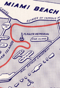 | Details | Anonymous | 1960 |
| Map and Brochure New Uncle Sam Cruise Tour Biscayne Bay Florida |
|
Anonymous |
|
| 1960 |
| LOC:11 |
| $80.00 | Anonymous | Map-and-Brochure-New-Uncle-Sam-Cruise-Tour-Biscayne-Bay-Florida | Brochure for a 2.5 hour touristic cruise of Biscayne Bay, Miami Beach, Florida aboard the glass-enclosed motorboat Uncle Sam. With a map of the path of the cruise (in red) around Biscayne Bay.
<br></br>
The diesel-powered 84-passenger Uncle Sam departed Pier 10 at the Miami Yacht Basin in Bayfront Park and passed the Venetian Islands, the Flagler Memorial, Fisher's Island then crossed the Rickenbacher Causeway. On the return to the yacht basin the Uncle Sam passed the bayfront estates of James Deering (Villa Viscaya), Charles Coryell, Damon Runyon, and more.
<br></br>
Detailed inset map of access roads and parking for the Uncle Sam cruise. Multi-lingual brochure ca. 1960's with key details translated and targeted to appeal to a Spanish-speaking audience: "Mostrando especialmente las mansiones de Cubanos y Portorriquenos en la zona residential…"
<br></br>
Printed on both sides and folds to 4" x 9". |
| 1397 | 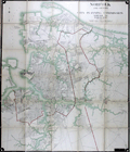 | Details | Norfolk City Planning Commission | 1924 |
| Large 1921 Planning Commission Map of Norfolk, Virginia and Vicinity |
|
Norfolk City Planning Commission |
|
| 1924 |
| LOC:2001 |
| $1,000.00 | Norfolk-City-Planning-Commission | Large-1921-Planning-Commission-Map-of-Norfolk--Virginia-and-Vicinity | Impressive huge lithographed folding map of Norfolk in the Commonwealth of Virginia. Boundary lines mark the city's boundary with Norfolk County and to its east Norfolk County's boundary with Princess Anne County. This 1924 edition is the first revision of the original 1921 Norfolk City Planning Commission map (other revisions were in 1928 and 1939). Compiled by Paul F. Mueller C.E., who worked for Sanborn Map Co. until 1906. (Norfolk Virginia: Evolution of a City in Maps. Berent, Irwin M. Norfolk History Publihers. 2013. pp. 23-25. <a href="https://books.google.com/books?id=sQsvAQAAQBAJ&pg=PA25&lpg=PA25&dq=Norfolk+and+Vicinity,+City+Planning+Commission+map+1921&source=bl&ots=BHr35I7PFg&sig=qOBa1pA-rTOpTKgYZ26zxMS-_3w&hl=en&sa=X&ved=0ahUKEwjE_L-p5oTYAhVR1IMKHSIWCXEQ6AEIRzAJ#v=onepage&q=Norfolk%20and%20Vicinity%2C%20City%20Planning%20Commission%20map%201921&f=false" target="_blank">Online.</a>)
<br></br>
Numerous printed notes of historical interest, for example: "Near this spot was the "Mother Church" of Elizabeth River Parish. See Book 4, Page 175, 3 January 1684." Key features on this map include Willoughby Bay, Boush Creek, Mason Creek, Little Creek, Elizabeth River, Lafayette River, Craney Island, and Port Norfolk.
<br></br>
Pencil annotation for Ward's Corner.
<br></br>
Norfolk is located at the heart of the Hampton Roads metro area. Named for the large natural harbor of the same name located at the mouth of Chesapeake Bay, Norfolk It is one of nine cities and seven counties that constitute the Hampton Roads metro area. The city has a long history as a military and transportation hub. The largest Navy base in the world, Naval Station Norfolk, is located in Norfolk, Va.
<br></br>
With label for C.S. Wertsner & Sons, Maps and Mounting, 50 North 13th Street, Philadelphia, Pa. Lithographed by A. Hoen and Co., Baltimore. |
| 1371 |  | Details | Butler, Lowell | 1952 |
| Fine Baby-Boom Era Pictorial Map of California |
|
Butler, Lowell |
|
| 1952 |
| LOC:0 |
| $155.00 | Butler--Lowell | Fine-Baby-Boom-Era-Pictorial-Map-of-California | Large, attractive poster-size map of California's historical sites created during the post-war baby-boom era of the early 1950s. Numerous sites are numbered on the map. Includes extensive notations on the verso related to a whopping 496 sites in California. Cartography By Lowell Butler.
<br></br>
Verso contains textual descriptions related to the precise location and a brief history of each of the 496 sites.
A few examples of the sites include: <br><br/>
<hr>
<ul>
<li><strong>1-- Customs House. Alvarado, Main and Scott Streets, Monterrey.</strong><i> The port of entry for vessels and cargo reaching California during the days of Spanish and Mexican occupation...</i></li>
<li><strong>411-- Campo Store. Campo, San Diego County</strong><i> A frontier trading post and border fort built by Luman H. and Silas E. Gaskill who settled here in 1868.</i></li>
<li><strong>190-- Painted Rock. 7 miles southeast of Corona on State Highway No 71, Riverside County. </strong><i>A boulder with Indian pictographs applied (probably of Louiseno origin), registered and marked in 1927. What the pictographs mean has not been determined.
<hr></i></li>
</ul>
According to David Rumsey "The sites are identified by whether they are from the Spanish-Mexican Period, Years of the Gold Rush, Agricultural Era or Commercial and Industrial Expansion era. . With insets: San Francisco Bay; Monterey sites; Los Angeles and vicinity sites; San Diego sites; Mother lode sites. On verso: 'A note of explanation by Phil Townsend Hanna'; descriptive list of historical sites with color drawings, numbered to correspond with sites on map."
<br></br>
Compiled from the official registrations of the California State Department of Natural Resources. By Phil Townsend Hanna and William Webb. Copyright 1952 by the Automobile Club of Southern California. Published by Westways, Vol. 44, No. 12. |
| 1333 |  | Details | U.S. War Department | 1934 |
| Old War Department Map of New Orleans Area 1934 |
|
U.S. War Department |
|
| 1934 |
| LOC:1401 |
| $450.00 | U-S--War-Department | Old-War-Department-Map-of-New-Orleans-Area-1934 | Large, original War Department / U.S. Corps of Engineers blueprint index map from 1934 for south-eastern Louisiana including New Orleans, Donaldsonville, Baton Rouge, Mandeville, Slidell and Bay St. Louis. Names railways, numerous waterways and bodies of water, but does not show roads or highways. Includes the Bonnet Carre Floodway (completed 1931), the Harvey Locks, portions of the Intracoastal Canal (later called the Gulf Intracoastal Waterway or ICWW), Lake Borgne, Lake Ponchartrain, Barataria Bay, Atchafalaya Bay, and the Mississippi River as far south as Venice, Louisiana. Perfect for the man cave.
<br></br>
On this map the route shown for the Intracoastal Canal passes through Lockport, Louisiana and Bayou Terrebonne. The segment of the canal from Larose to Bourg, Louisiana to was not completed until 1949.
<br></br>
Dated within at bottom right to 1934. Drawn by L. Lecaze. |
| 1192 | 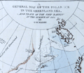 | Details | Manby, George William | 1823 |
| Journal of a Voyage to Greenland, in the year 1821 |
|
Manby, George William |
|
| 1823 |
| LOC:0 |
| $1,800.00 | Manby--George-William | Journal-of-a-Voyage-to-Greenland--in-the-year-1821 | An arctic whaling classic. Scarce second edition (1823) of this illustrated account of the whaling ship Baffin’s voyage with Captain Scoresby. The main purpose of the voyage was to test a new harpoon design by Scoresby. The voyage took them first to Spitzbergen, along the coast of Greenland, to Iceland and then home.
<br></br>
George Manby accompanied Captain Scoresby on the voyage into the northern Greenland Sea aboard the whaling ship Baffin. Manby creates a vivid picture of Arctic whaling as it was practiced during the early part of the 19th Century. Scoresby invented a harpoon gun and is also remembered for his life-saving apparatus. Numerous woodcuts in the text of whales, narwhal, and other arctic creatures.
<br></br>
With a fine hand-colored folding map "A General Map of the Polar Ice in the Greenland Sea and Track of the Ship Baffin in the Summer of 1821 by G.W. Manby (14" x 10"). Contains 20 uncolored lithographic plates illustrating the voyage. Five plates "Drawn on stone by J.D. Harding" are larger and folded:
<div class="indenttextblock">
<ul style="list-style-type: circle;">
<li>Striking a Whale with Third Harpoon</li>
<li>A Whale Upsetting a Boat</li>
<li>Lancing a Whale</li>
<li>A Bear Attacking A Boat</li>
<li>A Boat Going on the Tail of a Fish</li>
</ul>
</div>
In 1819 William Scoresby moved to Liverpool from Whitby where he built (1820) and commanded the whaling ship "Baffin". In 1822 Scoresby mapped the East coast of Greenland. The "Baffin" finally sank in 1830 when 19 out of 90 ships in the whaling fleet were lost in bad weather in the Davis Strait. Scoresby's plans, together with this scale model of his ship are in the Whitby Museum, Yorkshire, England.<a href="http://www.whitbymuseum.org.uk/hpmimages/index1.htm " target="_blank"> (Internet. 2016.)</a>
<br></br>
Printed for G. and W.B. Whittaker, Ave Maria Lane, London. 225 pages including an appendix illustrated with woodcuts of harpoons and lance heads. |
| 1144 |  | Details | George W. Walker Lithograph and Publishing Co | 1927 |
| Birds-eye View of Boston Harbor ca. 1927 |
|
George W. Walker Lithograph and Publishing Co |
|
| 1927 |
| LOC:0 |
| $295.00 | George-W--Walker-Lithograph-and-Publishing-Co | Birds-eye-View-of-Boston-Harbor-ca--1927 | Bird's-eye map of Boston Harbor and surrounding region to the east. This folding pocket map is Walker's earliest view of Boston with the new airport, constructed in 1923, that would eventually become Logan International Airport. At far upper right are the yards of the <b>Fore River Ship and Engine Company</b> with two vessels shown under construction.
<br></br>
Numerous steamers, sailboats, and sailing ships are shown underway in the waters offshore Boston, Massachusetts; Winthrop and Spectacle Island. This edition of Walker's map only shows steamer routes for the <b>Nantasket Beach Line Steamers</b> to Nantasket Beach and other points to the east.
<br></br>
The map extends from the coastal area of East and South Boston across the water to the main ship channel and the Boston Light. It locates Winthrop, Thompson's Island, Moon Island, Deer Island, Nahant, Green Island, the Brewster Islands, Strawberry Hill, Fort Warren, Hough's Neck and much more. Several key streets are identified within Boston: Atlantic Avenue, Freeport, Summer Street, Broadway, Dorchester Street, and State Street to name a few.
<br></br>
Copyright Walker Lithograph and Publishing Company, Boston.
<br></br>
Single-color chromolithograph. The bird's eye map folds into manilla board cover titled "Boston Harbor" in manuscript. Map is attached to the cover as issued. Cover apparently made by the seller whose stamp appears on the cover in red ink: "H.A. Shepard and Company. Stationers 50 - 52 Cornhill Boston". Price in manuscript: 15 cents. An unusual find! |
| 304 | 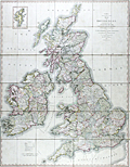 | Details | Cary, John | 1828 |
| Cary's Reduction of his Six Sheet Map of the British Isles |
|
Cary, John |
|
| 1828 |
| LOC:0 |
| $450.00 | Cary--John | Cary-s-Reduction-of-his-Six-Sheet-Map-of-the-British-Isles | Large, beautifully hand-colored antique folding map of the entire British Isles. John Cary's first map of the post roads, dated 1828. Good example of this map first published in 1796. Inset at upper right of the Shetland Isles. Maritime features include: the Atlantic Ocean, the German Ocean, the North Sea, the Irish Sea, St Georges Channel, and the English Channel.
<br></br>
Hand colored, dissected, and backed unto linen when issued. Folds into 42 parts. Marbled endpapers and complete with a green marbled slipcase to match that is labeled "Cary's two-sheet map of the United Kingdom." Published by G. and J. Cary, 86 St. James Street, London. |
| 995 | 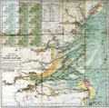 | Details | Stanford, Edward | 1920 |
| Stanford's Colored Chart of the Thames Estuary |
|
Stanford, Edward |
|
| 1920 |
| LOC:0 |
| $145.00 | Stanford--Edward | Stanford-s-Colored-Chart-of-the-Thames-Estuary | 2 coloured lithographic charts mounted on linen and folding into the same original cloth covers with paper label. With a tide table and 12 small inset maps showing tidal flows in knots over a 12 hour period based on high-water at Dover.
<br></br>
Two folding charts, the largest mounted on linen and both folding into the same original cloth covers with paper label.
<br/>
--Estuary Chart "Stanford's Chart of the Thames Estuary Prepared Under the Supervision of Captain O.M. Watts, A.I.N.A.". 28" x 27".
<br/>
--River Thames. "The River Thames from London to Gravesend". 20" x 6"
<br></br>
Original blue cloth boards with mounted printed publisher's plate to front cover. Published by Edward Stanton, 12, 13, & 14, Long Acre, W.C.2 London and Whitehall S.W.1 |
| 756 | 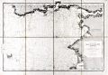 | Details | Depot de la Marine | 1907 |
| Antique nautical chart of Brittany Coast near the Vilaine River |
|
Depot de la Marine |
|
| 1907 |
| LOC:0 |
| $425.00 | Depot-de-la-Marine | Antique-nautical-chart-of-Brittany-Coast-near-the-Vilaine-River | Antique chart of the west coast of France from the Anse de Cornaud and Pointe du Grand Mont southward to le Croisic. First published in 1826, this chart of Brittany includes part of the Department of Morbihan, and the mouths of the Penerf and Vilaine rivers. The chart is updated as of 1907. Settlements and habitations covered include Cornaud, Saint-Gildas-de-Rhuys, Chateau de Suscino (en ruins), Damgan, Port de Billiers, Penestin (Pennetin), Mesquer, Piriac-sur-Mer, la Turballe, Guerande, Clie, and Saille. The chart extends westward to include the Ile d'Hoedic and many surrounding smaller islets of the greater and lesser Cardinaux Islands.
<br></br>
Very extensive and minute detail of the shoreline and near shore areas with elevation denoted by fine hachuring. Hundreds of individual structures are placed accurately. Thousands of soundings with isobath contour lines and navigational hazards would have aided the coastal navigator in the area.
<br></br>
This is a early 20th century linen-mounted folding chart, an updated edition of a chart first published by France's Depot de la Marine in 1826. This sea chart is based on the original surveys conducted in 1820 and 1821 under the supervision of Charles-François Beautemps-Beaupré (1766-1854), considered to be the father of modern French hydrography. Linen verso is printed via letterpress with "De La Pointe du Grand-Mont AU CROISIC. Entrée de la Vilaine." |
| 758 |  | Details | Depot de la Marine | 1908 |
| Antique nautical chart of Quiberon Bay with islands of Belle-Ile, Hoedic, and Houat |
|
Depot de la Marine |
|
| 1908 |
| LOC:66 |
| $425.00 | Depot-de-la-Marine | Antique-nautical-chart-of-Quiberon-Bay-with-islands-of-Belle-Ile--Hoedic--and-Houat | Antique lithographed chart of waters offshore of the west coast of France from southwest of the village of Saint Gildas and the Pointe du Grand-Mont. First published in 1826, this chart near the Brittany coast in western France includes the peninsula of Presqu'ile Quiberon and is the edition of January 1903 published with the latest updates in 1908.
<br></br>
Very extensive and minute detail of the shorelines and near shore areas with elevation denoted by fine hachuring. Thousands of soundings with isobath contour lines and navigational hazards would have aided the coastal navigator in the area. At the far right a particularly dangerous area for navigators, the "Plateau de la Recherche" is highlighted in brown
<br></br>
This is a early 20th century linen-mounted folding chart, an updated edition of a chart first published by France's Depot de la Marine in 1827. This lithographed nautical chart is based on the original surveys conducted during 1820 and 1821 under supervision of Charles-François Beautemps-Beaupré (1766-1854), considered to be the father of modern French hydrography. Beautemps-Beaupre was one of the earliest hydrographers to use isobaths to represent water depth.
<br></br>
Linen verso is printed via letterpress with "BELLE-ILE Entrée de la Baie de Quiberon. Iles Houat et Haedik". Number 135. |
| 636 |  | Details | Depot de la Marine | 1793 |
| Cote Meridionale d'Espagne depuis Cadiz jusqu'au Cap de Palos |
|
Depot de la Marine |
|
| 1793 |
| LOC:0 |
| $900.00 | Depot-de-la-Marine | Cote-Meridionale-d-Espagne-depuis-Cadiz-jusqu-au-Cap-de-Palos | Exceptional antique French nautical chart of the Western Mediterranean Sea, including the southern coasts of Spain and France and the northern coast of Africa. Nearly perfect condition. Coverage on this handsome folding sea chart extends from Cadiz, Spain eastward past Cape Trafalgar, Gibraltar, Malaga, Cartagena, to Cape Palos. Hundreds of named towns, villages, and geographic features ring the coastline with depth soundings, but virtually no interior details. Latitude and longitude scales.
<br><br/>
With the circular stamp of the French Depot de la Marine. Price when issued: Three Francs. No. 93.
<br><br/>
Exterior of the original linen cover contains a decorative octagonal seller's label: "Ch. Piquet, Geographe ordinaire DU ROI et de S.A.R. Monseig(neur) le Duc d'Orleans. A Paris Quai de Conti No. 17, entre l'Hotel des Monnaies et le Pont des Arts." |
| 567 | 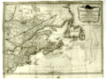 | Details | Sayer, Robert and Bennett, John | 1776 |
| A General Map of the Northern British Colonies in America |
|
Sayer, Robert and Bennett, John |
|
| 1776 |
| LOC:200 |
| $1,750.00 | Sayer--Robert-and-Bennett--John | A-General-Map-of-the-Northern-British-Colonies-in-America | Scarce antique map of the British colonies in North America during the Revolutionary War. Dated August 14, 1776. Coverage includes Maryland, Pennsylvania, New Jersey, New York, Massachusetts, Connecticut, New Hampshire, Maine, and the provinces of what is now Canada. Notes locations of American Indian tribes.
<br></br>
This map has been referred to as the "Beaver map" because of a prominent beaver in the title cartouche as well as some text related to a then unexplored portion of upstate New York: <div class="indenttextblock">"This vast tract of land which is the Antient Couchcachrage one of the four beaver hunting countries of the six nations is not yet surveyed."</div>
</br>
At very top is a second title: "The seat of war in the Northern Colonies containing the province of Quebec, Newfoundland, Nova-Scotia, New England, New York, New Jersey, Pennsylvania, etc.".
<br></br>
This map was originally one of six maps published by Sayer and Bennet in "The American Military Pocket Atlas; Being An Approved Collection of Correct Maps, Both General and Particular, of The British Colonies". David Rumsey notes that this is one of three maps in the atlas that were important to the mapping of the American Revolution. As Rumsey explains:<div class="indenttextblock"> "Nicknamed the 'Holster Atlas' because it was made for the use of British army officers. All maps in outline color, folded and bound into book with paper covered boards and quarter leather with "American Pocket Atlas" stamped in gilt on the spine."</div>
</br>
Watermarked with a shield containing a fleur de lis surmounted with a crown: at the bottom is "GR". Bottom attribution reads: London, Printed for Robert Sayer and John Bennett, Map and Seachart sellers No 53 Fleet Street, as the act directs, 14th Aug. 1776., |
| 539 |  | Details | Donnet, Alejo | 1831 |
| Algarbe, Andalucia, Granada |
|
Donnet, Alejo |
|
| 1831 |
| LOC:0 |
| $575.00 | Donnet--Alejo | Algarbe--Andalucia--Granada | Map of the Algarve region in Portugal, southwest Spain, and the Strait of Gibraltar, with numerous city insets: Seville, Merida, Tarifa, Murviedro, Cadiz, Algeciras and Gibraltar. Large, attractive, well-kept, linen-backed folding map has been dissected into 18 sections of about 5.5 x 7.5 inches when issued. <BR> </BR>
The map's source is Donnet's six-sheet "Mapa Civil y Militar de España y Portugal, con la nueva división en distritos." Shows the Portuguese and Spanish coasts from Cape St. Vincent to well past Malaga along with the North African coast, Strait of Gibraltar, and Mediterranean Sea. Political regions and divisions are outlined in red. Published by Dauty and sold by Simonneau ca. 1831 from Paris. Hoja 4. <BR> </BR>
Contains two altitudinal cross sections. Detailed insets of key cities with prominent points identified and tied to a key for each city.<BR> </BR>
The map is unusual in that it presents 11 different measurement scales in alignment:<BR>
Leguas Geograficas de Espana<BR>
Leguas Legales de Espana<BR>
Leguas de Aragon<BR>
Leguas de Mallorquinas<BR>
Leguas Municipales Valencianas<BR>
Legoas communes de Portugal<BR>
Leguas Marimas o de 1 hora de Camino<BR>
Myriametres 10 por un grado decimal<BR>
Lieues de Poste de France 2000 toises<BR>
Lieues communes de France 2285 toises<BR>
British miles 1760 yards<BR> </BR>
Cover contains the seller's label in very fine condition that reads:<br>
"Magasin de Geographie de Charles Simonneau Graveur.
A Paris, Rue de la Paix, No. 6. Hotel Mirabeau vis-à-vis le Timbre. <br>
Cartes Geographiques et Topographiques Francaises et Etrangeres.<br>
Globes, Spheres, Atlas. Geographie, Ancienne et Moderne.<br>
(In manuscript): Espagne & Portugal Sud Ouest."<BR> </BR>
Not dated but Charles Simonneau was a French engraver, map publisher, and map seller in Paris, France from approximately 1803 to 1838. Grave par les Freres Malo, Rue du Ges No. 10. Pres la Sorbonne. |
| 540 |  | Details | Donnet, Alejo | 1831 |
| Cuenca, Valencia, Murcia, Baleares |
|
Donnet, Alejo |
|
| 1831 |
| LOC:0 |
| $550.00 | Donnet--Alejo | Cuenca--Valencia--Murcia--Baleares | Antique map of the Balearic Islands: Ibiza, Formentera, Mallorca ( Majorca ), Menorca ( Minorca ); the Mediterranean Sea, and the East coast and interior of Spain. Published by Dauty and sold by Simonneau from Paris ca. 1831. Title printed on the map reads: "Cuenca, Valencia, Murcia, Baleares". The map's source is Donnet's six-sheet "Mapa Civil y Militar de España y Portugal, con la nueva división en distritos."
<BR> </BR>
Large, attractive, well-kept, linen-backed folding map dissected into 18 sections of about 5.5 x 7.5 inches as issued. Maps the Balearic Islands and the East coast of Spain from Mar Menor near Cartagena north to Barcelona. Political regions and divisions are outlined in red. <BR> </BR>
Cover contains the seller's label in very fine condition that reads:<br>
"Magasin de Geographie de Charles Simonneau Graveur.
A Paris, Rue de la Paix, No. 6. Hotel Mirabeau vis-à-vis le Timbre. <br>
Cartes Geographiques et Topographiques Francaises et Etrangeres.<br>
Globes, Spheres, Atlas. Geographie, Ancienne et Moderne.<br>
(In manuscript): "Espagne (illegible) centrales."<BR> </BR>
Not dated but Charles Simonneau was a French engraver, map publisher, and map seller in Paris, France from approximately 1803 to 1838. Engraving is attributed as: "Grave par les Freres Malo, Rue du Gres No. 10. Pres la Sorbonne." Contains index tab at top of the map: "No. 4". |
| 541 |  | Details | Donnet, Alejo | 1831 |
| Suplemento a los Planos de Ciudades |
|
Donnet, Alejo |
|
| 1831 |
| LOC:2001 |
| $500.00 | Donnet--Alejo | Suplemento-a-los-Planos-de-Ciudades | Scarce, detailed, antique folding map of plans for key cities in Spain and Portugal: Barcelona (still surrounded by a fortified wall), Ciudad Rodrigo, Tortosa, Oviedo, Denia, Cadiz, Granada, Lisbon (Lisboa), Madrid, Cartagena, and Valencia. The map was published as a supplement to Donnet's six-sheet "Mapa Civil y Militar de España y Portugal, con la nueva división en distritos."
<BR> </BR>
Large, attractive, well-kept, and linen-backed. Dissected into 18 sections of about 5.5 x 7.5 inches as issued. Published by Dauty and sold by Simonneau from Paris ca. 1831. The map is identified at top as the seventh and last part. <BR> </BR>
Cover contains the seller's label in very fine condition that reads:<br>
"Magasin de Geographie de Charles Simonneau Graveur.
A Paris, Rue de la Paix, No. 6. Hotel Mirabeau vis-à-vis le Timbre. <br>
Cartes Geographiques et Topographiques Francaises et Etrangeres.<br>
Globes, Spheres, Atlas. Geographie, Ancienne et Moderne.
With an index tab at top of the folded maps that reads: "Plans des Villes"<BR> </BR>
Not dated but Charles Simonneau was a French engraver, map publisher, and map seller in Paris, France from approximately 1803 to 1838. Attribution at bottom reads: " A Paris. Chez Dauty et Demaisons Palais Royal Galerie de Nemours, et Malo aine Graveur Rue St. Jacques No. 169." |
| 288 |  | Details | Depot de la Marine | 1895 |
| Cote est D'Irlande de la Baie de Dublin de la Baie de Belfast |
|
Depot de la Marine |
|
| 1895 |
| LOC:0 |
| $275.00 | Depot-de-la-Marine | Cote-est-D-Irlande-de-la-Baie-de-Dublin-de-la-Baie-de-Belfast | Interesting and uncommon folding 1895 edition (bottom of chart) of an antique nautical chart first printed in 1875. This intact linen-backed large folding chart of the Irish sea was published by the French Admiralty (Depot des Cartes et Plans de la Marine). Covers a wide area of Ireland and western portions of Britain including Belfast and Dublin , Isle of Man, and Holyhead Island. Lighthouses highlighted in yellow.<BR> </BR>
The antique chart folds to 5" x 9 1/2". Folds into 3 sections horizontally and 8 sections vertically. With a printed seller's sticker on front: " Maison Andriveau Goujon. Henry Barrere, Editeur-Geographe. 21 Rue du Bac, Paris". On the sticker below the seller's attribution is a script annotation of the chart title and a date of 1906.<BR> </BR>
Insets of the Port of Killough, Port of Ardglass, and a small view of the entrance to the Bay of Dundalk. Platemark is apparent but the chart is probably lithographic due to late 19th century provenance. Number 3460. Price: two francs. |
| 346 | 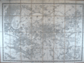 | Details | Depot General de la Guerre | 1857 |
| Environs de Paris. |
|
Depot General de la Guerre |
|
| 1857 |
| LOC:0 |
| $220.00 | Depot-General-de-la-Guerre | Environs-de-Paris- | Antique folding map of Paris, France and its environs by the French war department originally published in 1839. This revised edition from 1857 has an emphasis on the Seine river and includes Versailles. Backed with coarse brown linen, the map is divided into eight horizontal sections and 4 vertical sections and folds to a compact 6" x 8 3/4".<BR> </BR>
The antique map is annotated at bottom with a circular, blue seller's stamp from "E. Andriveau-Goujon - Geographe" and an oval blind-stamp by the "Depot de la Guerre". Scale 1:40,000. When folded the front cover contains a decorative black and white sticker from E. Andriveau-Goujon Geographe, editeur, Rue du Bac 21, Paris . The sticker details the many specialties of his shop including: globes, spheres, Atlas de Choix, and cartes de parties du monde. |