| | Thumbnail | | Creator | Date | Title / Author / Date / Location | Price | | | Description |
| 1395 | 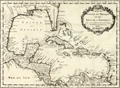 | Details | Bellin, Jacques Nicolas | 1754 |
| Gulf of Mexico and Caribbean Antique Original Map |
|
Bellin, Jacques Nicolas |
|
| 1754 |
| LOC:0 |
| $0.00 | Bellin--Jacques-Nicolas | Gulf-of-Mexico-and-Caribbean-Antique-Original-Map | SOLD<br></br>
Original mid 18th-century French map of the Texas, Louisiana, Alabama, Florida, coastline with the Gulf of Mexico, Central America, Caribbean islands and Antilles.
<br></br>
Framed, glazed, and double matted. Size with frame 20" x 17".
<br></br>
This original antique map by Nicolas Bellin contains the tracks of explorers including Cortez, Ponce de leon, and the lesser-known Francisco Hernández de Córdoba, an early explorer of Mexco's Yucatan peninsula.
<br></br>
Published in a French edition of L'Abbe Prevost's "Histoire Générale des Voyages". Tome 12, No. 1. |
| 1452 | 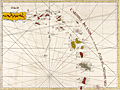 | Details | Jefferys, Thomas | 1775 |
| Jefferys Sayers Chart of Caribbee Islands Virgin Islands to Barbados |
|
Jefferys, Thomas |
|
| 1775 |
| LOC:0 |
| $0.00 | Jefferys--Thomas | Jefferys-Sayers-Chart-of-Caribbee-Islands-Virgin-Islands-to-Barbados | SOLD <br></br>
Exciting antique British chart of the "Caribbee Islands" -- Caribbean Islands. Chart coverage includes the Virgin Islands (St. Thomas, St. Croix, St. John's, Tortola…), Antigua, Guadeloupe, Dominica, Martinique, St. Lucia, St. Vincent, and Barbados.
<br></br>
The chart is from the scarce <b>first issue of The West-India Atlas, 1775 by Sayer</b>, the other issues being 1781, 1787, 1794, 1796, 1807, and 1818 published by Sayer and then Laurie and Whittle. <a href="https://www.davidrumsey.com/home" target="_blank">(Online).</a>
<br></br>
One French online site of Martinique describes key features of Jefferys' nautical chart:
<hr>
<div class="indenttextblock">
C'est une carte marine à latitudes croissantes de 20 lieues marines au degré. Elle est très esthétiquement quadrillée de rhumbs, éléments indispensables à l'époque pour obtenir l'adhésion des utilisateurs. Elle est de plus joliment agrémentée de représentations, somme toute très sobres, de vaisseaux de diverses nations, qui n'entravent pas le caractère opérationnel de la carte.
</BR>
Quelques rares sondes indiquent dans les principaux canaux et passes les profondeurs marines. Elles sont parfois présentes sur les dangers reconnus. Entre Saint-Eustache et Avès, Jefferys met en évidence la longue barrière de hauts fonds dont la largeur atteindrait en moyenne deux lieues marines et la profondeur entre 10 et 20 fathoms.
</BR>
Jefferys y précise que certaines sondes ont été prises par les français, marins à bord du navire le «Toulouse», en 1720. La carte présente les itinéraires des principaux "débouquements", notamment celui des Vierges, qui était employé par la plupart des marines pour le retour en Europe. <a href="http://cartes-martinique.pagesperso-orange.fr/Car_gb.htm" target="_blank">(Online.)</a>
<hr>
</div> |
| 754 | 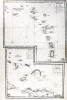 | Details | Depot de la Marine | 1775 |
| Antique French nautical chart of the eastern Bahamas and the Antilles |
|
Depot de la Marine |
|
| 1775 |
| LOC:0 |
| $0.00 | Depot-de-la-Marine | Antique-French-nautical-chart-of-the-eastern-Bahamas-and-the-Antilles | SOLD
<br></br>
Two antique French nautical charts of the Bahamas and Antilles islands. Dated to 1775 within both title cartouches and attributed to French Naval Captain Jean Rene-Antoine Verdun De La Crenne (1741-1805), Alexandre Guy Pingre, and Jean-Charles de Borda.
<br></br>
Both copper-plate engraved charts printed in a single impression on one large sheet of heavy wove paper. Soundings and navigational hazards noted on the charts attest to their expected use aboard ships of the French Navy.
<br></br>
Lower chart includes eastern Cuba (including Baracoa); the eastern Bahama islands; the Turks (les iles Turques) and Caicos Islands (Gran de Cayque de Nord); and the northwest portion of the island of Hispaniola (partie de l'Ile de St. Dominque). Within the Bahamas coverage includes part of Long Island, Rum Cay, (Wattelin) San Salvador Island, Crooked Island, Mayaguana, Little Inagua Island, and Inagua Island.
<br></br>
Upper chart of the Lesser Antilles extends from eastern Puerto Rico through the Leeward and Windward Islands. Coverage includes the Virgin Islands with Saint Croix, Saint John, and Saint Thomas; and the islands of St. Kitts, Nevis, Anguilla, St. Martin, St. Barts, Barbuda, Antigua, Montserrat, Guadeloupe, Marie-Galante, la Desirade, Dominica, Martinique, St. Lucia, Barbados, and St. Vincent. |
| 1459 | 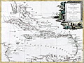 | Details | Zatta, Antonio | 1785 |
| French, English and Spanish Islands in the Caribbean Sea |
|
Zatta, Antonio |
|
| 1785 |
| LOC:10 |
| $425.00 | Zatta--Antonio | French--English-and-Spanish-Islands-in-the-Caribbean-Sea | Fine antique decorative map of the Caribbean Islands "Arcipelago delle Antille" with a beautiful and colorful title cartouche published from Venice, Italy. Shows Florida as an archipelago of islands. Antonio Zatta issued this attractive antique engraving in his "Atlante Novissimo" in 1785. |
| 602 | 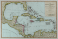 | Details | Dunn, Samuel | 1786 |
| Compleat Map of the West Indies |
|
Dunn, Samuel |
|
| 1786 |
| LOC:0 |
| $0.00 | Dunn--Samuel | Compleat-Map-of-the-West-Indies | SOLD<br></br>
Scarce antique nautical map focused on the Caribbean and the Gulf of Mexico. Interesting representation of Florida with the southern portion of that state shown as an archipelago of islands. Map coverage includes New Orleans, <b>Pensacola</b>, St. Augustine, <b>Amelia Island</b>, The Bahama Islands, Cuba, Jamaica, Puerto Rico, Virgin Islands, Leeward and Windward Islands, North Coasts of Colombia and Venezuela, Bay of Honduras, and Bay of Campeche. Earlier editions of this antique map are commonly found in the "The American Military Pocket Atlas" nicknamed the "Holster Atlas", issued to British Officers during the American Revolutionary War.
<br></br>
An interesting note on the map explains the derivation of terms "Windward" and "Leeward" to differentiate among two groups of islands in the southern Caribbean: <br><div class="indenttextblock ">
"The distinction between the Leeward and Windward Islands which is not commonly understood arose from the following circumstances. It was a custom going to the West Indies to make Island Desirada, the wind from the tropics blowing always from the East. All the islands to ye N. and W. of Desirada lay to the Leeward and all ye islands to the E. or S. lay to Windward of such ship's course T.P."</div>
<br></br>
The author, Samuel Dunn (d. 1794), taught navigation and other mathematical subjects and published several works on navigation, nautical science, and on astronomy. Published for Robert Sayer in June 1786. London. No. 53 Fleet Street. Plate 41. |
| 1471 |  | Details | Brion, Louis, de la Tour | 1790 |
| Guyane, Terre Ferme. Isles Antilles et Nouvelle Espagne |
|
Brion, Louis, de la Tour |
|
| 1790 |
| LOC:10 |
| $130.00 | Brion--Louis--de-la-Tour | Guyane--Terre-Ferme--Isles-Antilles-et-Nouvelle-Espagne | Antique map of the Caribbean Archipelago, Mexico, and the southeast United States. Map is set within a page of French text related to the map. |
| 964 | 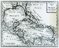 | Details | Anonymous | 1800 |
| Antique map of the Gulf of Mexico and Caribbean Sea |
|
Anonymous |
|
| 1800 |
| LOC:0 |
| $0.00 | Anonymous | Antique-map-of-the-Gulf-of-Mexico-and-Caribbean-Sea | SOLD <br></br>
Antique copper-plate engraved map of the Caribbean, <b>Gulf of Mexico</b>, Central America and portions of Colombia and Venezuela. This original old map ca. 1800 shows Florida as an archipelago of islands as well as the key cities of Havana, Cuba; Saint Augustine and Pensacola, Florida; Mobile, Alabama; <b>New Orleans, Louisiana</b>; and Port-Royal, Jamaica. Because the wide area encompassing the Louisiana Purchase is labeled as "Louisiana" we can date the map to prior to 1803, the date of that transaction.
<br></br>
After a map produced by J.B. Nolin for his "<i>Atlas Général a l'usage des colleges et maisons d'education</i>". Plate 25, |
| 1470 | 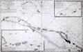 | Details | Depot de la Marine | 1801 |
| French antique chart of the Bahamas old channel and northern Cuba |
|
Depot de la Marine |
|
| 1801 |
| LOC:67 |
| $489.00 | Depot-de-la-Marine | French-antique-chart-of-the-Bahamas-old-channel-and-northern-Cuba | French antique navigation chart of the "Vieux Canal" or old canal of the Bahamas. Other features (in French) include Canal de Santarem and Banc de Los Rocques. Inset chart of the anchorage near Cayo Blanco ("les Cayes de Piedras, Monillo, et autres ajacentes") and of the anchorage at Cayo Verde and Cayo Confites. Circular logo of the Depot de la Marine. |
| 524 |  | Details | Depot de la Marine | 1806 |
| Carte Generale des Isles Antilles |
|
Depot de la Marine |
|
| 1806 |
| LOC:51 |
| $775.00 | Depot-de-la-Marine | Carte-Generale-des-Isles-Antilles | Large, rolled, copperplate engraved antique 'brown-back' working sea chart of the Caribbean (Antilles) issued by the French Depot de la Marine in 1806. Coverage includes from eastern Puerto Rico and its islands of Culebra and Vieques, the British Virgin Islands, Anguilla, St. Kitts, Nevis, Montserrat, Antigua, Barbuda, Guadeloupe, Dominica, Martinique, St. Lucia, St. Vincent, Grenada, Barbados, Trinidad and Tobago to the Venezuelan coast. The lower portion of the map covers the northern coast of Venezuela including the cities of Cumana and Barcelona. Numerous French place names, soundings and navigation hazards are noted.
<BR> </BR>
Chart is covered with brown linen; probably contemporary to its issue based on the wear pattern. Blueback charts, covered in blue linen, or heavy paper are much more common, These brown back charts are not often found. The linen has done a good job of protecting the map and maintaining it's fine condition over the last 200+ years.
<BR> </BR>
With the circular stamp of the French Depot de la Marine. No 187. Price 3 Francs. |
| 1286 | 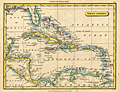 | Details | Tryer, James | 1822 |
| Antique map of the Caribbean Sea and the Spanish Main |
|
Tryer, James |
|
| 1822 |
| LOC:5 |
| $195.00 | Tryer--James | Antique-map-of-the-Caribbean-Sea-and-the-Spanish-Main | Antique map of the West Indies at the beginning of the 19th century by James Tryer. The area covered stretches from Florida in the north the Gulf of Darien in the south and from the Yucatan peninsula in the west to the Orinoco river in the east. Includes portions of the Atlantic Ocean, Gulf of Mexico, Caribbean Sea, Pacific Ocean, and Sea of Honduras. The northern coast of South America is labeled "The Spanish Main".
<br></br>
James Tyrer was a prolific engraver from Pentonville, London who flourished during the early part of the nineteenth century. This neat map was published by John Souter in Clark's A New General School Atlas in 1822. |
| 5329 | 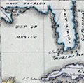 | Details | Cruttwell, Eliza Ann | 1824 |
| Fine antique manuscript map of West Indies Caribbean Florida |
|
Cruttwell, Eliza Ann |
|
| 1824 |
| LOC:11 |
| $435.00 | Cruttwell--Eliza-Ann | Fine-antique-manuscript-map-of-West-Indies-Caribbean-Florida | A very fine antique pen and ink manuscript map of the West Indies or Caribbean Sea stretching from Florida to South America. This beautiful one-of-a-kind map reflects extreme precision in execution with careful attention to fine detail and lettering. The map is original and 196 years old; it looks beautiful and fresh.
<br></br>
Shows and labels the provinces of West Florida and East Florida, on a Florida peninsula that has a squared-off form unlike other modern maps of the period and more like Mark Catesby's map of 1743. Includes the islands of Cuba, Santo Domingo, Porto Rico, Trinidad, Barbados, and many of the other usual suspects you would expect to see on a map of the West Indies.
<br></br>
This manuscript antique map of the West Indies, dated within to November 1824, is by signed by E. A. Cruttwell (probably Eliza Ann Cruttwell) (nee Wilson) the wife of Clement Wilson Cruttwell (1780-1816). Eliza Ann Cruttwell (1783-1858) was born in London, England.
<br></br>
Eliza Cruttwell's father-in-law, Rev. Clement Cruttwell (1743-1808) was a well known English publisher of maps and atlases. Clement Cruttwell is best known for his work "The New Universal Gazetteer ; or Geographical Dictionary … with twenty-eight whole sheet maps". London. Pub. G. Kearsley. 1798. That large gazetteer, in 3 volumes, was published in 19 editions. Clement Cruttwell's maps were published by G. G. & J. Robinson from London in 1799 in a separate atlas.
<br></br>
This map was part of a larger lot of manuscript maps by E. A. Cruttwell from the same atlas. |
| 5319 | 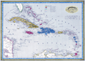 | Details | Dufour, Adolphe Hippolyte | 1850 |
| Antique Map of the Caribbean or Antilles |
|
Dufour, Adolphe Hippolyte |
|
| 1850 |
| LOC:11 |
| $255.00 | Dufour--Adolphe-Hippolyte | Antique-Map-of-the-Caribbean-or-Antilles | Fine engraved antique map of the Caribbean Islands from Florida to Venezuela. Map created by French cartographer A. H. Dufour ca. 1850.
<br></br>
Islands are colored according to the country who's possession each island was ceded to- England, Spain, France, Holland, Denmark, or Sweden. Legend or table at top center assigning colors to each occupying nation.
<br></br>
Engraved by Leclercq. Published by Mangeon. |
| 1437 | 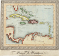 | Details | Thompson, Henry A. | 1850 |
| Manuscript naval student map of the Caribbean Islands |
|
Thompson, Henry A. |
|
| 1850 |
| LOC:0 |
| $0.00 | Thompson--Henry-A- | Manuscript-naval-student-map-of-the-Caribbean-Islands | SOLD <br></br>
Original mid 19th-Century manuscript map in black ink and watercolor, showing southern Florida, islands of the Caribbean/West Indies and part of Central and South America. Set within an elaborate border.
<br></br>
The creator has signed the map "Henry A. Thompson" and inscribed it "Elson House Academy / near Gosport June 9, 1850". "Near Gosport" suggests that Thompson may have drawn this map while aboard ship, perhaps during a summer training cruise.
<br></br>
It is likely that Henry Thompson was a student at a naval preparatory training establishment, as Gosport, near Portsmouth in Hampshire was a major sea port on the south coast of England at this time. The introduction in 1838 of an entrance examination for the Royal Navy, encouraged the development of specialised educational establishments like Elson House Academy, Dr. Burney's Academy, and nearby Stubbington House School. |
| 5082 | 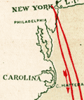 | Details | Atlas Steamship Company | 1896 |
| Track of the Atlas Line showing the Special Cruises Season 1897 - 98. |
|
Atlas Steamship Company |
|
| 1896 |
| LOC:0 |
| $90.00 | Atlas-Steamship-Company | Track-of-the-Atlas-Line-showing-the-Special-Cruises-Season-1897---98- | Map of the Caribbean Sea for the <b>Atlas Steamship Company</b> showing their special passenger cruises in a six-panel folding brochure "Special Cruises of the Atlas Steamship Company's Mail Steamers to the West Indies & the Spanish Main."
<br></br>
Ports visited on the Special Cruises included New York; Port Royal, Jamaica; Cartagena, Colombia; Barranquilla (Sabanilla), Colombia; and Port Limon, Costa Rica. The twenty-five day cruise cost on $125.
<br></br>
With an ink stamp on the cover for an unknown reading room. Brochure folds to 4" x 8". |