| | Thumbnail | | Creator | Date | Title / Author / Date / Location | Price | | | Description |
| 653 | 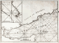 | Details | Anonymous | 1750 |
| Gulf of Aden and Yemen |
|
Anonymous |
|
| 1750 |
| LOC:0 |
| $375.00 | Anonymous | Gulf-of-Aden-and-Yemen | Uncommon anonymous mid-18th century British nautical chart labeled "Arabian Gulph". Includes the lower Red Sea, Gulf of Aden, Coast of Yemen, and the island of Socotra. Includes parts of the Somalian coast. Copperplate engraved working chart on chain laid paper with no watermark.
<br></br>
Lack of a title, authors name, or date makes the source of the chart hard to place but the style, English wording, and lack of a longitude scale is consistent with British charts published ca. 1740 - 1770. The missing title information or any form of attribution is in itself unusual, as during the period when this map was produced, publishers were only too happy to "borrow" other's works to be sold under their own name.
<br></br>
Noted geographical features include Mocha and Aden in Yemen, Zea Hill, Birim Island (I. Babel-Mandel ), The Eight Islands, Cabo St. Anthony, Black Point, The Asses Ear, Doffar, Bird Island, Berbera ( Barbara ), Cape Guardafui ( Guardafoy ) , Somalia and part of the Gulf of Tadjoura and Djibouti. We have been unable to locate another example of this chart.
<br></br>
Plate 2. |
| 3690 | 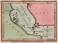 | Details | Luffman, John | 1801 |
| Antique map of the Red Sea and Bab al-Mandab Strait for Luffman's Select Plans |
|
Luffman, John |
|
| 1801 |
| LOC:77 |
| $230.00 | Luffman--John | Antique-map-of-the-Red-Sea-and-Bab-al-Mandab-Strait-for-Luffman-s-Select-Plans | Fine copper-plate engraved plan of the Bab al-Mandab Strait (Babel Mandel) at the mouth of the Red Sea. Includes the villages of Assab (Asab), Eritrea and Mocha (Moka), in Yemen. The Bab al-Mandab Strait connects the Red Sea to the Gulf of Aden. Other key features noted on the map include Purim (Mehta) Island, Cape Rasel, Pilot Island or Robands and the Lofty Islands.
<br></br>
From "Luffman's Select Plans of the Principal Cities, Harbors, Forts etc. in the World". Engraved and published by John Luffman, No. 28 Little Bell Alley, Coleman Street. London. November 1, 1801. Volume II, Number 53.
<br></br>
Luffman also provided similar engravings to this at about the same time for J.T. Serres' "The Little Sea Torch: or, True Guide for Coasting Pilots." Serres translated the Little Sea Torch from an earlier illustrated coasting pilot guide, based on Bougard's "Le petit flambeau de la mer", first published in 1684.
<br></br>
John Luffman (1751-1821) began his career as an engraver, producing a very large and fine map of Antigua, where he had resided in 1787 and 1789. That map was published by Luffman to accompany his 'A Brief Account of the Island of Antigua', 1788." Luffman shared the same sad fate as many publishers and was declared bankrupt on 9th March, 1793. Moving forward Luffman was more cautious and produced small format atlases and handy-sized maps of the theatres of war, principal towns and cities and battle-plans relating to the Wars of the French directorate and the subsequent Napoleonic War. |