| | Thumbnail | | Creator | Date | Title / Author / Date / Location | Price | | | Description |
| 4879 | 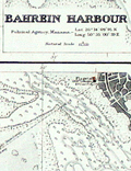 | Details | British Admiralty Hydrographical Office | 1944 |
| Plans on the North East Coast of Bahrein Island |
|
British Admiralty Hydrographical Office |
|
| 1944 |
| LOC:54 |
| $0.00 | British-Admiralty-Hydrographical-Office | Plans-on-the-North-East-Coast-of-Bahrein-Island | SOLD
<br></br>
Very scarce nautical charts of Bahrain (Bahrein) Harbor, Khor Kaliya, and Manama. 1936 / 1944. Charts are based on surveys by the British Admiralty's surveying ship "Ormonde" in 1932. Shows Bahrain's major population center, port and harbors before most of the massive construction that now fills the area.
<br></br>
No other example of this map is found online and only one sale of the 1905 edition in 2008.
<br></br>
Three charts / plans on one page:
<div class="indenttextblocksingle">
<ul style="list-style-type: circle;">
<li>Approaches to Bahrein Harbor and Khor Kaliya</li>
<li>Bahrein Harbour</li>
<li>Khor Kaliya</li>
</ul>
</div>
Last correction 1944. Chart # 3792. Published at the Admiralty 14th Aug. 1936 under the
Superintendence of Rear Admiral J.A. Edgell. |