| | Thumbnail | | Creator | Date | Title / Author / Date / Location | Price | | | Description |
| 1222 | 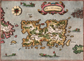 | Details | Porcacchi, Tomasso | 1576 |
| Scarce map of Puerto Rico, San Giovanni or Borichen |
|
Porcacchi, Tomasso |
|
| 1576 |
| LOC:5 |
| $350.00 | Porcacchi--Tomasso | Scarce-map-of-Puerto-Rico--San-Giovanni-or-Borichen | Fine sixteenth-century map of the Caribbean island of Puerto Rico, or Borichen as it was known by the indigenous Taino Indians. One of the earliest available maps specifically of Puerto Rico. San Juan is noted as S. Giovanni.
<br></br>
Contains the eastern coast of Cuba and a scattering of islands ( Le Vergini ) representing the British Virgin Islands. At bottom left is seen S. Croce (St. Croix). A large island off the southeast coast of Puerto Rico, "El Bacan" is probably the nearby island of Vieques. Numerous sea serpents swim in the offshore waters.
<br></br>
Printed in Tomasso Porcacchi's "Isolario" or island book "L'Isol Piu Famose Del Mondo". That work contains a number of finely engraved maps of islands and the continents at a reduced scale. Porcacchi (1530-1585) was born in Tuscany to a poor family and first settled in Florence. He wrote about history, geography, and archaeology and later published the Isolario from Venice, Italy in three editions beginning in 1572. Italian text on verso. |