| | Thumbnail | | Creator | Date | Title / Author / Date / Location | Price | | | Description |
| 1440 | 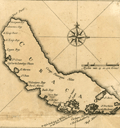 | Details | Popple, Henry | 1742 |
| Antique plan of Curacao in the Caribbean Sea |
|
Popple, Henry |
|
| 1742 |
| LOC:0 |
| $0.00 | Popple--Henry | Antique-plan-of-Curacao-in-the-Caribbean-Sea | SOLD <BR> </BR>
Antique chart fragment ca. 1742 of the island of Curacao in the Caribbean Sea. Noted locations include Cassarts Landing Plaats, Valentyn's bay, Porto Maria, Willemstad, Fort Beekenburg, Fort Collenburg, St. Jeris, and Verse Bay droog. Attractive compass rose and rhumb lines.
<br></br>
This antique map was originally published by Covens and Mortier in 1742 in "Les Principales Forteresses Ports etc. de L'Amerique Septentrionale" a sheet containing harbor and island maps and plans of the Americas. This map is a fragment trimmed from the larger sheet.
<br></br>
That sheet of 18 maps and plans of islands and harbors was published by Covens and Mortier to replace Popple's original large map of 20 sheets with a more manageable six-sheet version. Popple's original map was titled: "A Map of the British Empire in America with the French, Spanish and the Dutch Settlements adjacent thereto". |
| 1448 |  | Details | van Keulen, Gerard | 1775 |
| Curacao by Gerard van Keulen West-India Atlas Jefferys Sayer |
|
van Keulen, Gerard |
|
| 1775 |
| LOC:51 |
| $1,800.00 | van-Keulen--Gerard | Curacao-by-Gerard-van-Keulen-West-India-Atlas-Jefferys-Sayer | Fine, very desirable chart of Curaçao in the Lesser Antilles of the Caribbean Sea. Inset plan of Fort Amsterdam, in Willemstad, constructed in 1634 by the Dutch West India Company. A beautiful British published chart based on hydrographic surveys by Dutch cartographer Gerard van Keulen.
<br></br>
The chart is from the scarce <b>first issue of 1775 by Sayer</b>, the other issues being 1781, 1787, 1794, 1796, 1807, and 1818 published by Sayer and then Laurie and Whittle. <a href="https://www.davidrumsey.com/home" target="_blank">(Online).</a>
<br></br>
From: "The West-India Atlas: or, A Compendious Description of the West-Indies: illustrated with Forty Correct Charts and Maps, taken from Actual Surveys. Together with An Historical Account of the Several Countries and Islands which compose that part of the world. Their Discovery, Situation, Extent, Boundaries, Product, Trade, Inhabitants, Strength, Government, Religion, &c."
Authors: Gerard van Keulen, Thomas Jefferys.
Publishers: Robert Sayer.
Jefferys died in 1771; Sayer acquired Jefferys' materials in preparation for this atlas, and published the atlas posthumously under his name. |