| | Thumbnail | | Creator | Date | Title / Author / Date / Location | Price | | | Description |
| 7974 |  | Details | Kroll Map Company | 1944 |
| Evergreen Playground View of Pacific Northwest First State |
|
Kroll Map Company |
|
| 1944 |
| LOC:130 |
| $250.00 | Kroll-Map-Company | Evergreen-Playground-View-of-Pacific-Northwest-First-State | This pictorial map, titled The Evergreen Playground, (first state with the Tacoma Narrows Bridge lacking a deck) was published in 1944 by the Kroll Map Company of Seattle. It presents a detailed bird’s-eye view of western Washington, extending from Olympia and Tacoma northward through Seattle and Everett to Bellingham and Vancouver, B.C., and eastward to the Cascade Mountains. The map highlights major highways, railways, ferry routes, and points of interest, emphasizing the transportation network and recreational attractions of the Pacific Northwest at mid-century. Drawn by Ed Poland.
<br><br>
Insets along the borders depict regional scenery, industry, and Native American–inspired motifs. The lower right legend identifies the “Unequaled Transportation Facilities” that connect the area by train, highway, and ferry service. The title panel describes the region as unique in North America for combining sea, forest, and mountain environments within a compact area. Printed in full color with topographic shading and decorative borders, this map reflects the Kroll Company’s skill in cartographic illustration and mid-20th-century regional promotion.
<br><br>
Ed (Edwin) Poland was a long-time chief cartographer at the Seattle-based Kroll Map Company, active from at least the 1930s through the postwar era. Poland’s work for Kroll is characterized by dense place-name coverage, promotional vignettes, and clear drafting that made the firm’s Pacific Northwest maps popular for decades. |
| 7907 |  | Details | Sebring Board of Trade | 1920 |
| Maps and Views of Sebring Florida |
|
Sebring Board of Trade |
|
| 1920 |
| LOC:500 |
| $350.00 | Sebring-Board-of-Trade | Maps-and-Views-of-Sebring-Florida | In 1920, just nine years after George E. Sebring acquired over 9,000 acres in the Florida Highlands to establish a new town, the Sebring Board of Trade published this substantial promotional pamphlet titled "Sebring, Florida. The City of Health and Happiness." By the time this brochure was circulated, Sebring's population had grown to around 3,000 residents. The historic downtown area of Sebring, which still reflects its 1920s origins, has been recognized as a Historic District on the National Register of Historic Places, acknowledging its significance and the enduring legacy of George E. Sebring's vision for the city.
<br><br>
The pamphlet is packed with text and photographs showcasing nearly every beneficial aspect of life in Sebring. The back cover features a bird's-eye view of the town encircling Lake Jackson, with "Twelve miles of velvet asphalt boulevard surrounding the Twilight Trail." Inside the front cover, another bird's-eye view depicts a fountain nestled among lush trees and meticulously landscaped formal gardens, described as "Sebring's beautiful little park around which the town revolves."
<br><br>
Within the pages, readers will find a map of peninsular Florida highlighting the area around Sebring, accompanied by a table displaying distances to various locations within the state. The pamphlet culminates with a pictorial map of the region immediately surrounding Sebring, illustrating the town's layout with the central park as its focal point, encircled by vast orange groves that stretch out into the surrounding countryside.
<br><br> |
| 7893 |  | Details | Oberbacher, Hans | 1958 |
| Lido di Jesolo beach near Venice Italy |
|
Oberbacher, Hans |
|
| 1958 |
| LOC:86 |
| $255.00 | Oberbacher--Hans | Lido-di-Jesolo-beach-near-Venice-Italy | Fine birds-eye view, "Lido di Jesolo", with Venice, Italy at the left. By Hans Oberbacher. 1958.
<br><br>
Lido di Jesolo, a popular seaside resort town, is situated within the metropolitan city of Venice, Italy. It is well known for its long sandy beach and vibrant nightlife, and it serves as a popular tourist destination, especially during the summer months. Lido di Jesolo is situated on the Adriatic coast close to Venice, making it a convenient location for visitors looking to enjoy both the beach and the historic city of Venice.
<br><br>
The region surrounding Jesolo has been featured in cartographic works dating back to the 14th century or earlier, crafted by renowned cartographers such as Pietro Vesconte, Fra Mauro, Benedetto Bordone, and Vincenzo Maria Coronelli, among others. These prior charts provide insight into the development of the Venetian Lagoon over time.
<br><br>
Jesolo has a history that dates back to ancient Roman times when it was known as Equilium, meaning "city of horses." The area was largely abandoned during the Middle Ages due to the decline of the Roman Empire and encroachment of the surrounding marshlands.
<br><br>
During the era of the Republic of Venice, which lasted from the 8th to the 18th century, the Venetians began to drain and reclaim the land for agriculture and fishing. The first settlements were established in the 19th century, and the town was renamed Cavazuccherina.
<br><br>
The opening of the first beach resort in 1911 marked the beginning of tourism in Lido di Jesolo. However, it was not until the post-World War II period that the town experienced a significant boom in tourism. During the 1950s and 1960s, rapid development and urbanization transformed Lido di Jesolo into one of the most popular seaside resorts in Italy. |
| 7875 |  | Details | Holladay, John | 1992 |
| Rare Apocalyptic Los Angeles After Earthquake Puzzle |
|
Holladay, John |
|
| 1992 |
| LOC: |
| $385.00 | Holladay--John | Rare-Apocalyptic-Los-Angeles-After-Earthquake-Puzzle | Scarce and fun 1000 piece pictorial puzzle titled LA Shake and Bake, created in 1992 by illustrator John Holladay and published by F. X. Schmid. Puzzle is unopened in original shrink wrap as issued. <br><br>The puzzle presents a satirical pictorial view of Los Angeles shattered by a massive quake, with districts sliding toward the Pacific Ocean in a dense and humorous cartoon style. The image plays on long standing California earthquake lore. It was also issued by Schmid as an uncut poster. When assembled, the puzzle measures 26.5 by 17.25 inches.<br><br>
Holladay's theme draws on the popular misconception that California might someday break off along the San Andreas Fault, an idea that traces back to public misunderstanding of Andrew Lawson's 1906 report describing lateral motion after the San Francisco earthquake. His phrasing that the Pacific side moved northward relative to the American side echoed for decades, inspiring exaggerated public fears and giving artists like Holladay fertile ground for satirical disaster scenes. The puzzle captures that cultural myth with vivid color and a chaotic, engaging layout.<br><br>
LA Shake and Bake also reflects the long publishing history of F. X. Schmid, founded in Munich in 1860 and best known for toys, cards, and later board games and puzzles. By the 1970s and 1980s the company had expanded internationally, including a U.S. division that produced widely distributed puzzles like this one. Financial pressures in the mid 1990s led to a 1997 merger with Ravensburger, marking the end of Schmid as an independent maker. This puzzle stands as one of the imaginative late period Schmid releases, combining contemporary humor, geological lore, and striking packaging design.
<br><br>
Box size roughly 15.5" x10". |
| 7868 |  | Details | Howell and Graves | 1925 |
| Muscle Shoals, Alabama City of Unlimited Opportunity |
|
Howell and Graves |
|
| 1925 |
| LOC:130 |
| $450.00 | Howell-and-Graves | Muscle-Shoals--Alabama-City-of-Unlimited-Opportunity | Muscle Shoals, Alabama, a small city nestled along the Tennessee River, is perhaps best known today for its outsized influence on American music. The iconic "Muscle Shoals Sound," born in the city's legendary recording studios, has left an indelible mark on genres ranging from soul and R&B to rock and country.
<br><br>
But a century ago, Muscle Shoals was the epicenter of a different kind of boom - one fueled by grand industrial ambitions and the promise of a brighter future.
<br><br>
In the 1920s, automotive pioneer Henry Ford set his sights on transforming the sleepy Alabama town into a bustling metropolis to rival Detroit (1). The centerpiece of this vision was the Wilson Dam, a hydroelectric marvel that would provide cheap, abundant power to fuel the growth of industry.
<br><br>
Sensing an opportunity, New York City developers Howell and Graves began heavily promoting Muscle Shoals as the "City of Unlimited Opportunity." This advertising brochure, circa 1925, with a rare birds-eye view map showcases their grand plans. The map, which stretches from Seven Mile Island to the Wilson Dam, depicts a thriving industrial landscape, with the Tennessee River winding majestically in the background.
<br><br>
At the time, nitrate plants were the region's biggest employers, and the promise of readily available electricity was expected to lure even more manufacturers to the area. Howell and Graves themselves invested heavily in the city's future, constructing the first City Hall, homes, and the Howell and Graves Jr. High School, which still stands today as a Board of Education building.
<br><br>
However, the grand vision for Muscle Shoals was not to be. Much of the infrastructure built by Howell and Graves went unused as the Great Depression stifled the city's growth. The promised industrial boom never materialized, and Muscle Shoals settled into a quieter existence.
<br><br> |
| 6845 |  | Details | Fairchild Aerial Surveys Inc. | 1930 |
| Scarce view of Hollywood Stars Homes Beverly Hills |
|
Fairchild Aerial Surveys Inc. |
|
| 1930 |
| LOC:89 |
| $400.00 | Fairchild-Aerial-Surveys-Inc- | Scarce-view-of-Hollywood-Stars-Homes-Beverly-Hills | Scarce, early photographic oblique "airplane" birds-eye view of Beverly Hills, California annotated with numerals keyed to homes of Hollywood stars. These movie stars include Buster Keaton, Tom Mix, Mary Pickford, Douglass Fairbanks, Charles Chaplin, Marlene Dietrich, and Will Rogers. The view probably dates between 1926 and 1933 based on the marriage duration of King Vidor and Eleanor Boardman (Home # 22) . By Fairchild Aerial Surveys, N.Y.C. Published in an unknown magazine. Verso with glamour photographs of period stars.
<br><br>
The view looks roughly north with the Beverly Hills Hotel, established 1912, slightly to the left of the center. This item may be the earliest published aerial photograph of Photomap of Beverly Hills to locate the homes of movie stars and likely predates Landacre's "Newe Mappe of the Heavens."
<br><br><div class="indenttextblocksingle">
"When Wallace Beery flies back from his island camp, or when Ben Lyon volplanes down home to see Bebe and the baby, this is where the magic carpet of Hollywood looks to the returning wanderers of the sky."
</div><br> |
| 6661 | 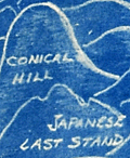 | Details | Henshell, J. | 1945 |
| Cyanotype pictorial map of Okinawa, Japan post WWII |
|
Henshell, J. |
|
| 1945 |
| LOC:86 |
| $350.00 | Henshell--J- | Cyanotype-pictorial-map-of-Okinawa--Japan-post-WWII | This is an original, rare cyanotype blueprint map, self published by J. Henshell, likely a soldier stationed on Okinawa, Japan. It depicts a birds-eye view of the Island of Okinawa, Japan and is dated November 1945, just three months after the surrender of Japan, or V-J Day (1). Henshell's design showcases his appreciation for local Okinawan art and culture, depicting shrines, temples, and tombs in a local artistic style. Local airfields and airbases are shown in rectangular boxes (e.g. Kadena, Futema, Yontan). After a Japanese Imperial Land Survey conducted in 1931.
<br><br>
The design also highlights the hills that played a significant role in the Battle of Okinawa. The island's rugged terrain made them difficult to attack. American forces faced fierce resistance from entrenched Japanese defenders during the battle. Henshell labels three of these key locations: Sugar Loaf Hill, the Conical Hill (Mount Yaedake), and the Japanese Last Stand.
<br><br>
Sugar Loaf Hill was a heavily fortified Japanese defensive position that played a significant role in the Battle of Okinawa. Today, it is a peaceful park and memorial site called the Okinawa Peace Memorial Park. The transformation of Sugar Loaf Hill from battlefield to symbol of peace is a testament to the strength of the people of Okinawa.
<br><br>
Mount Yaedake, also known as Conical Hill, was a key location in the Battle of Okinawa during World War II, as it was heavily fortified by Japanese defenders and provided a natural defensive position. Today, Mount Yaedake is a popular tourist destination, known for its stunning views of the surrounding area.
<br><br>
<div class="indenttextblock">
(1) Nakagusuku Bay, located on the eastern coast of Okinawa, was renamed Buckner Bay in honor of Lieutenant General Simon Bolivar Buckner Jr., who served as commanding General US Army's 10th Army Division during the Battle of Okinawa. Buckner was the highest-ranking US officer to be killed during the battle.
</div> |
| 6658 |  | Details | Mount Tamalpais and Muir Woods Railroad | 1923 |
| Birds eye view Map of the Pacific Coast in the vicinity of San Francisco |
|
Mount Tamalpais and Muir Woods Railroad |
|
| 1923 |
| LOC:3 |
| $295.00 | Mount-Tamalpais-and-Muir-Woods-Railroad | Birds-eye-view-Map-of-the-Pacific-Coast-in-the-vicinity-of-San-Francisco | An attractive original antique four-panel bird's eye view / map of the California Pacific coast in the vicinity of San Francisco Bay and San Pablo Bay from 1923.
<br><br>
Elevation is shown in relief. The view stretches from Mount Shasta at top left to the Farallon Islands at the bottom right and extends from Lake Lagunitas at bottom left to Mount Hamilton. Includes towns ranging around San Pablo Bay and San Francisco Bay: San Jose, San Francisco, Palo Alto, Oakland, Sausalito, Napa, Sonoma, and Walnut Creek. At bottom left is a table of air line distances from the summit of Mt. Tamalpais. Sacramento is 73 miles distant and Mt. Shasta a long 237 mile crow-flight from Mt. Tamalpais.
<br><br>
The map comprises four of eight panels of a brochure issued by the Mount Tamalpais and Muir Woods Railroad. Printed by Leighton Press, San Francisco, California. Dated in the plate at 1923. Verso includes photos and text. |
| 6649 |  | Details | Perkins, T.C. | 1905 |
| 1905 Connecticut Valley Electric Transit Route Pictorial |
|
Perkins, T.C. |
|
| 1905 |
| LOC:41 |
| $250.00 | Perkins--T-C- | 1905-Connecticut-Valley-Electric-Transit-Route-Pictorial | Birds'-eye view pictorial map of the Connecticut Valley, following the Connecticut River. Shows the Electric Transit Trolley Route from Hartford, Connecticut To Greenfield, Massachusetts. The route includes the towns of Hartford, Chicopee, Springfield, Holyoke, Greenfield, and Turner Falls with population centers shown pictorially in profile.
<br><br>
The Connecticut Valley Electric Transit Route was a trolley line that operated in the early 20th century, specifically from 1905 to 1926, in the Connecticut River Valley region of Massachusetts. The line was a part of the Springfield Street Railway Company, which was one of the largest electric streetcar systems in the United States at the time.
<br><br>
The Connecticut Valley Electric Transit Route ran from Springfield to Holyoke, Northampton, and Amherst, and it was an important transportation link for people living in those areas. The trolley line connected these towns and allowed for easy travel between them, which was especially important for college students attending schools in the region, such as Amherst College and Smith College.
<br><br>
Mount Tom is a mountain located in Holyoke, Massachusetts, in the Connecticut River Valley region. The mountain has an elevation of 1,202 feet (366 meters) and offers sweeping views of the surrounding area.
In the early 20th century, Mount Tom was a popular tourist destination, and it was a common stop on the Connecticut Valley Electric Transit Route. The trolley line had a station at the base of the mountain, and visitors could take a funicular railway up Mount Tom. Once at the top of Mount Tom, visitors could enjoy a range of activities, including hiking, picnicking, and even a zoo. The mountain was also home to a popular amusement park, which featured a roller coaster, a Ferris wheel, and other rides and attractions.
<br><br>Published by T.C. Perkins Hartford, Connecticut 1905. E.A. Sherman del. |
| 6626 |  | Details | Casey-toons | 1997 |
| Pictorial View of Jacksonville Florida Skyline and Jaguars Stadium |
|
Casey-toons |
|
| 1997 |
| LOC:150 |
| $500.00 | Casey-toons | Pictorial-View-of-Jacksonville-Florida-Skyline-and-Jaguars-Stadium | 1997 glossy advertising-oriented poster- a view of the Jacksonville, Florida skyline with a focus on the Jacksonville Jaguars NFL-team stadium, surrounded by Jaguars. Copyright Jacksonville, Jaguars LTD 1997. Produced and distributed by Casey-Toons , II, Inc. An official team illustration.
<br><br>
Above the stadium float blimp-like footballs containing blank scoreboards with the names and date of upcoming Jaguars football games.
<br><br>
Dedicated to Dave and signed in ink by Casey 4-29-97.
<BR><BR>
Includes numerous Jaguars. Here a Jaguar, there a Jaguar. Everywhere ... |
| 6538 | 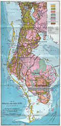 | Details | Weston, T.W. | 1919 |
| Map of Pinellas County Florida with Fishing Grounds |
|
Weston, T.W. |
|
| 1919 |
| LOC:300 |
| $250.00 | Weston--T-W- | Map-of-Pinellas-County-Florida-with-Fishing-Grounds | Colorful lithographed map (8" x 16") of Pinellas County, Florida in 1919 by T.W. Weston issued in a folding 4" x 9" brochure by the Pinellas County Board of Trade. In addition to the Pinellas County map, the brochure includes a fine small oblique birds-eye view - "Dunedin - a typical coast town" (Fig 1.), a small regional distance chart extending for 1500 miles from Pinellas County (Fig 2.), descriptive text, and numerous photographs. <br><br>
<div id="1" align="center">
<a title="Dunedin, Florida Birds-eye View"></a>
<img id="1" src="/ZoomifyImages/SC_6538/SC_6538_Detail1.jpg" alt="Dunedin, Florida 1919 Birds-eye View" width="320"/> <br><small>Fig. 1 - 1919 Birds-eye View of Dunedin, Florida.</small>
</div><br>
The Pinellas County map shows soil type (coastal beach, Parkwood loam, tidal marsh …) indicated by color overlaid with routes of steam railroads, electric railways, three types of roads, canals, and drainage districts.
<br><br>
<div id="2" align="center">
<a title="Pinellas County Distance Chart"></a>
<img id="2" src="/ZoomifyImages/SC_6538/SC_6538_Detail2.jpg" alt="Distance chart related to Pinellas County Florida." width="250"/> <br><small>Fig. 2 - Statute mile distances from Pinellas County.</small>
</div><br>
Red font denotes species of fish found around Pinellas County (Fig. 3) These fish include tarpon, trout, channel bass (redfish), mackerel, and kingfish.<br><br>
<div id="3" align="center">
<a title="Pinellas County Fish Species"></a>
<img id="3" src="/ZoomifyImages/SC_6538/SC_6538_Detail3.jpg" alt="Detail from Pinellas County Map." width="250"/> <br><small>Fig. 3 - Detail of Pinellas County fish species.</small>
</div> |
| 6486 |  | Details | Maslin, John A. | 1985 |
| America's Cup pictorial bird-eye view of Freemantle, Western Australia |
|
Maslin, John A. |
|
| 1985 |
| LOC:1404 |
| $350.00 | Maslin--John-A- | America-s-Cup-pictorial-bird-eye-view-of-Freemantle--Western-Australia | Attractive oblique pictorial birds-eye view map of the town and harbor of Freemantle, Western Australia. July 1985 edition. Copyrighted and produced by Ausimap, Perth. Cartography by John A. Maslin.
<br><br>
In addition to Cockburn Sound and Freemantle Harbor the expansive birds-eye view shows Success Harbor, the fishing boat harbor, and the America's Cup harbour at Freemantle.
<br><br>
Two years before this map was published, and for the first time in 132 years, the America’s Cup was won by a team from other than the USA. That year, in Rhode Island, Australia II, skippered by John Bertrand defeated Dennis O'Conner on the Liberty. In 1987 the America's Cup race was held in Freemantle, Australia where the Stars & Stripes 87 won the series in a four-race sweep. |
| 5450 |  | Details | F.A. Bennett | 1925 |
| Rare view Fairyland Point Fleetwood Hotel Ormond-on-the-Bay and Muriel Estates |
|
F.A. Bennett |
|
| 1925 |
| LOC: |
| $350.00 | F-A--Bennett | Rare-view-Fairyland-Point-Fleetwood-Hotel-Ormond-on-the-Bay-and-Muriel-Estates | Rare, unrecorded antique 1920's panoramic birds-eye view of Ormond-on-the-Bay and Muriel Estates, Florida with the Fleetwood Hotel. Photograph of a painting showing Ormond-on-the-Bay and Muriel Estates both promoted by F.A. Bennett Developments. Inset of the Fleetwood Hotel. Probably a postal card. Framed.
<br></br>
The Fleetwood Hotel was a planned 300-room 15-story resort hotel with a casino, tennis courts, pool, ballroom on what is now part of Tomoka State Park. The Fleetwood Hotel, promoted by a developer called "Commodore" J. Perry Stoltz, was to embody the luxury and decadence synonymous with the Roaring Twenties.
<br></br>
[1] Jarmusz, T.S. Did Ormond Beach pillars mark a fantasy hotel that never materialized?. Daytona Beach News-Journal. January 7, 2009. Accessed Online. |
| 5375 | 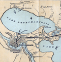 | Details | Louisville and Nashville Railroad | 1886 |
| Birds Eye View of Gulf Coast Louisville and Nashville Railroad |
|
Louisville and Nashville Railroad |
|
| 1886 |
| LOC: |
| $725.00 | Louisville-and-Nashville-Railroad | Birds-Eye-View-of-Gulf-Coast-Louisville-and-Nashville-Railroad | </br>"The Great Through Car Line Between the North and South."</br>
"Unrivaled in Speed, Construction and Equipment."
<br></br>
Fine bird's eye view of the central Gulf Coast highlighting the route of the Louisville and Nashville Railroad from Mobile, Alabama, through Mississippi, to New Orleans, Louisiana. The route includes Bay St. Louis, Ocean Springs, Pass Christian, Mississippi City, Biloxi, Pascagoula. Numerous steam-powered and wind-powered vessels are shown plying the waters of the Gulf of Mexico, Lake Ponchartrain and the Mississippi River.
<br></br>
Six-panel folding map, neatly folded inside a 64-page pamphlet (4.5 " x 7.25") titled "The Gulf Coast". With the ink stamp of Sam. B. Jones, General Agent, New York. Published by the passenger department of the Louisville and Nashville R.R.
<br></br>
Printed in Louisville, KY by the Press of the Courier-Journal Job Printing Company. |
| 5368 |  | Details | Money, Anton | 1943 |
| Rare cyanotype pictorial map Whitehorse, Yukon Territory, Canada |
|
Money, Anton |
|
| 1943 |
| LOC:55 |
| $1,250.00 | Money--Anton | Rare-cyanotype-pictorial-map-Whitehorse--Yukon-Territory--Canada | Very rare satirical, cyanotype pictorial view of the town of Whitehorse in the Yukon Territory of Canada dated within to October, 1943. A folk-art style humorous blueprint, bird's eye view of the city of Whitehorse by engineer Anton Money.
<br></br>
The view includes numerous annotated humorous scenes of daily life in Whitehorse including a Mountie dog-sled team, gold panning, gambling, drinking, whoring, the White Pass and Yukon Route narrow gauge railway and the Whitehorse railway station.
<br></br>
By explorer Anton Money with acknowledgements to Louis McCormick and Don Reikard.
<br></br>
No recorded sales or holdings of this view except for one copy at the library of the University of Calgary in Canada. |
| 5357 | 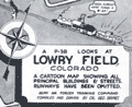 | Details | Grimes, George | 1944 |
| Pictorial map of Lowry Field Denver Colorado |
|
Grimes, George |
|
| 1944 |
| LOC:77 |
| $275.00 | Grimes--George | Pictorial-map-of-Lowry-Field-Denver-Colorado | A very scarce pictorial map of Lowry Field, at the eastern edge of Denver, Colorado, from the first issue of the Lowry Field Information Handbook [1] in November, 1944. Lowry field was activated in February, 1938 as the site of the Army Air Forces Training Command [2]. From the 1980’s, Lowry Air Force Base was one of Colorado’s largest employers. Lowry AFB employed nearly 10,000 military and civilian men and women, providing an economic impact annually approaching $1 billion [3].
<br></br>
<div class="indenttextblocksingle">
[1] Earliest publication was November, 1944 with a later edition of February, 1945. On the later map a telephone icon is added and locations of the telephone shelter house and telephone lounges are colored orange.<br>
[2] Information Handbook Lowry Field (AAF Training Command). Mountain States Telephone and Telegraph Company. Denver. 1944. Online.<br>
[3] https://wingsmuseum.org/about/history/. Online
</div> |
| 5334 |  | Details | National Aeronautics and Space Administration | 1966 |
| NASA glossy publicity photo of J . F. K. Space Center map |
|
National Aeronautics and Space Administration |
|
| 1966 |
| LOC:11 |
| $100.00 | National-Aeronautics-and-Space-Administration | NASA-glossy-publicity-photo-of-J---F--K---Space-Center-map | An original NASA unclassified glossy black and white publicity photograph of a NASA birdseye view map of the John F. Kennedy Space Center and the surrounding area in eastern and central Florida. Dated on verso to 8/8/66.
<br></br>
The photograph shows a map, apparently tacked to a bulletin board, ranging in coverage as far as Orlando, Oak Hills, and Eau Galle, Florida. Key points of interest shown include: McCoy Air Force Base, Patrick Air Force Base, Cocoa Beach, the St. Johns River, Indian River, Banana River, and Mosquito Inlet. At the lower left corner is a key or context map showing the location of the map relative to the entire state of Florida.
<br></br>
When the photo was published in August, 1966 NASA was winding down the last two of 19 Gemini program missions to place a capsule with two astronauts into Earth orbit. The final two launches in the Gemini program were:
<br></br>
<div class="indenttextblocksingle">
<ul style="list-style-type: circle;">
<li>Pete Conrad and Richard Gordon. Launched September 12, 1966</li>
<li>Jim Lovell and Buzz Aldrin. Launched November 11, 1966</li>
</ul>
</div> |
| 5264 |  | Details | Bodenher, Gabriel | 1704 |
| Antique bird's-eye view of Cote d'Azur Provence Nice Monaco |
|
Bodenher, Gabriel |
|
| 1704 |
| LOC:77 |
| $350.00 | Bodenher--Gabriel | Antique-bird-s-eye-view-of-Cote-d-Azur-Provence-Nice-Monaco | |
| 5253 | 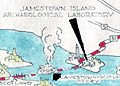 | Details | James River Ceramics Club | 1951 |
| Jamestown James River Ceramics Club Field Trip |
|
James River Ceramics Club |
|
| 1951 |
| LOC: |
| $350.00 | James-River-Ceramics-Club | Jamestown-James-River-Ceramics-Club-Field-Trip | Unrecorded and hand-colored pictorial route map for the James River Ceramics Club. Mid 20th-century birds-eye perspective map of the area surrounding the James River near Jamestown, Virginia, location of the first permanent English settlement in North America.
<br></br>
Made for the occasion of the first annual field trip of the James River Ceramics Club to the Jamestown Island Archaeological Laboratory and to James O'Donnell Pottery on Sunday, August 12, 1951. Shows the towns of Williamsburg, Hilton Village, Benn's Church, Bacon's Castle, Surry, Burrowsville and more. With the logo for the James River Ceramics Club. |
| 5136 | 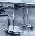 | Details | Seaboard Air Line Railway | 1904 |
| Antique Panoramic View of Havana Cuba |
|
Seaboard Air Line Railway |
|
| 1904 |
| LOC:51 |
| $550.00 | Seaboard-Air-Line-Railway | Antique-Panoramic-View-of-Havana-Cuba | Antique folding half-tone panoramic view of Havana, Cuba (1904) titled "Havana Harbor and City." A very fine view from a brochure by the Seaboard Air Line Railway "Cuba" promoting the route of the Peninsular and Occidental Steamship Company's steamship from Port Tampa to Key West, Florida to Havana.
<br></br>
A drawing, resembling a photograph, showing a panoramic view taken from the perspective of La Cabaña, (Fortaleza de San Carlos de la Cabaña). At upper right the view shows Morro Castle and lighthouse at the entrance to Havana Bay. Across the bay, the city of Havana shines, while sailing vessels and steam powered ships ply the waters of the bay. A reviewer of the period described the work as:
<div class="indenttextblocksingle">
<ul style="list-style-type: circle;">
… a panoramic view of Havana Harbor and City superbly reproduced in half-tone, the sky and water effects being especially meritorious, showing skillful overlay and press-work." [1].
</ul>
</div>
Brochure printed by Edgell Press. Cover to brochure included.
<BR></BR>
[1] Ryan, Charles B. Transportation. January 1904. No. 1. p. 29. |
| 5129 | 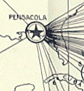 | Details | U.S. Army Engineers | 1929 |
| Port of Pensacola, Florida scarce photomosaic and two maps |
|
U.S. Army Engineers |
|
| 1929 |
| LOC:0 |
| $300.00 | U-S--Army-Engineers | Port-of-Pensacola--Florida-scarce-photomosaic-and-two-maps | Small booklet of 66 pages that includes 3 cartographic artifacts related to Pensacola, Florida.
<div class="indenttextblocksingle">
<ul style="list-style-type: circle;">
<li>Mosaic Composed of Aerial Photographs Pensacola Florida. Made by Air Service, U.S. Army 4th Photo Section. Dec. 22, 1922.</li>
<li>Origin of Imports and Destination of Exports Pensacola, Fla. 1928. Quantities expressed in cargo tons of 2240 lbs. and shown thus. 1929.</li>
<li>Port Facilities at Pensacola, Fla. 1929.</li>
</ul>
</div>
Along with many data tables and additional photographs the contents of the entire booklet include:
<div class="indenttextblocksingle">
<ul style="list-style-type: circle;">
<li>Port and Harbor Conditions</li>
<li>Port Customs and Regulations</li>
<li>Port Services and Charges</li>
<li>Fuel and Supplies</li>
<li>Port and Harbor Facilities</li>
<li>Communications</li>
<li>The freight rate situation</li>
<li>Commerce of the port</li>
<li>The territory tributary to the port</li>
<li>General</li>
</ul>
</div>
War Department Corps of Engineers and United States Shipping Board Port Series No. 3 Part 2 THE PORT OF PENSACOLA, FLORIDA.
Printed by the U.S. Government Printing Office, Washington, D.C. 1929. Price when issued 30 cents. |
| 5124 | 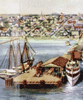 | Details | Straub, W.L. | 1917 |
| Antique airplane views of St. Petersburg Florida |
|
Straub, W.L. |
|
| 1917 |
| LOC:11 |
| $400.00 | Straub--W-L- | Antique-airplane-views-of-St--Petersburg-Florida | Brochure with maps and scarce airplane views of St. Petersburg, Florida including a fine oblique elevated view of the harbor: "St. Petersburg, the Place 'of Proved Desire and Known Delight' " by artist W.L. Straub (15" x 6"). Found at the center of a six-panel folding brochure- "St. Petersburg Florida, The Sunshine City Issued by the St. Petersburg Board of Trade."
<br></br>
Along with numerous smaller illustrations and photographs the brochure includes additionally two fine views and two maps:
<div class="indenttextblocksingle">
<ul style="list-style-type: circle;">
<li>View of the "mole", the "spa", the municipal pier and bathing beaches</li>
<li>Panoramic view of St. Petersburg, Fla. from the Plaza Theater (by Van Deventer & Sons 1913.</li>
<li>Map showing location of St. Petersburg Florida with Railroad and Steamship Connections.</li>
<li>Map of Pinellas County, Florida showing location of St. Petersburg "The Sunshine City".</li>
Brochure folds to 9" x 4". |
| 5103 |  | Details | Burgert Brothers | 1920 |
| Lakemont Florida Early Bird's-eye View |
|
Burgert Brothers |
|
| 1920 |
| LOC:11 |
| $125.00 | Burgert-Brothers | Lakemont-Florida-Early-Bird-s-eye-View | Scarce drawn bird's-eye view of Lakemont, Florida ca. 1920 as it was being platted and developed for sale. Below the scene of lots, lakes, and orange groves, a brief description explains the view (shown looking south):
<div class="indenttextblocksingle">
"Lakemont, located between Avon Park and Sebring, Fla., at the crossing of scenic highway and S.A.L.R.R. [Seaboard Air Line Railway]"
</div></br>
Description on the verso reads:
<div class="indenttextblocksingle">
"LAKEMONT, FLA. A new townsite now being developed and destined to become a city within the next few years, located in the Ridge Section at the crossing of scenic highway and new S.A.L. Railroad. Four miles north of Sebring and five miles south of Avon Park, Florida."
</div></br>
Major topographic features include the city of Sebring with Dinner Lake, Lake Jackson, Basket Lake, Bonnet Lake, and Little Red Water Lake.
<br></br>
Folding postal card in two panels. White border (1915-1930). No. 103139. Fl. Fla. Postally unused. Dated with reference to the founding of Sebring, Florida in 1912. Published by Burgert Brothers of Tampa, Florida. |
| 4996 |  | Details | Young, George F. | 1925 |
| St Petersburg Florida map issued by the CoC |
|
Young, George F. |
|
| 1925 |
| LOC:87 |
| $325.00 | Young--George-F- | St-Petersburg-Florida-map-issued-by-the-CoC | Map of St Petersburg, Florida drawn by engineer George F. Young and issued by the St. Petersburg Chamber of Commerce in 1925. Verso with an oblique birds-eye photo view of St. Petersburg, Florida looking toward land from offshore. Scarce.
<br></br>
George F. Young, Inc. is one of the oldest Florida engineering and surveying companies, established in 1919. Today G.F. Young, Inc. has professional offices located in St. Petersburg, Tampa, Lakewood Ranch, Gainesville, and DeBary, Florida
<br></br>
Shows the Coffee Pot Golf Club. In 1920, St. Petersburg developer, C. Perry Snell opened a 9-hole golf course along Coffee Pot Bayou called the <b>“Coffee Pot Golf Club.”</b> In 1926, Snell hired golf architects, Wayne Stiles and John van Kleek to build a modern 18-hole golf course. It was renamed the Snell Island Golf Course. In 1948, , known as Sunset Golf and Country Club, the operation was purchased by the Alsonett Hotel Corporation, and re-named the <b>Vinoy Golf Club.</b>
<br></br>
During February, 2019 Vinoy Golf Club was featured as Florida Historic Golf Trail Course of the Month by the Florida Department of State.
<br></br>
Publisher's colophon reads : "Map prepared in office of G.F. Young Civil and Landscape Engineer Drafting and Blueprints 633 Central Ave. St. Petersburg Fla." [FL. Fla.] |
| 4962 | 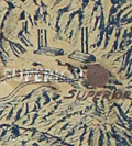 | Details | Hayden, T.A. | 1959 |
| Huge Unrecorded Map of the Salt River Project Phoenix Arizona |
|
Hayden, T.A. |
|
| 1959 |
| LOC:1409 |
| $2,500.00 | Hayden--T-A- | Huge-Unrecorded-Map-of-the-Salt-River-Project-Phoenix-Arizona | Large, very rare map of the first Federal hydroelectric energy project, updated to show hydrological improvements and issued revised 8-7-1959. An untitled birds-eye view map of the Salt River Project by T.A. Hayden, centered near Phoenix, Arizona. Similar to, but covering a larger area, than a small format map of the region by Hayden from 1934, now housed at Arizona State University.
<br><br>
Blue-line print hand-colored and enhanced with small red paste-on stickers and larger, manuscript lettering for cities. Shows the rivers, dams, reservoirs, lakes, and canals . Particular interest is indicated for reservoirs and canals as they have been hand colored in white and bright blue respectively.
<br></br>
The beginning of federal production of electric power occurred on the Salt River Project when Congress, in 1906, authorized the Reclamation Service to develop and sell hydroelectric power from the project. The map is significant because it was updated in 1959 when the original name "Salt River Dam #1" was changed to the name in use today: Roosevelt Dam.
<br></br>
Coverage is bound to the west by Gila Bend and to the east by Superior, AZ. Northern coverage ends above Prescott, Arizona, and to the south the map extends as far as Casa Grande.
<br></br>
The map has an interesting orientation with North oriented about 35 degrees to the left and that with the birdseye perspective, the large size, and the township and range grid of the Public Lands Survey System all give the map a commanding appearance.
<br></br>
In the 1930's T.A. Hayden was the Chief Assistant Engineer with the Salt River Valley Water User's Association, Phoenix. Copyrighted 1932 and Revised 1934 by T.A. Hayden. Final revision 1959. Phoenix, Arizona. |
| 4941 |  | Details | Boston and Maine Railroad | 1903 |
| Boston and Maine Railroad Summer Excursions with five maps |
|
Boston and Maine Railroad |
|
| 1903 |
| LOC:2001 |
| $350.00 | Boston-and-Maine-Railroad | Boston-and-Maine-Railroad-Summer-Excursions-with-five-maps | Rare booklet from the Boston and Maine Railroad (1903) with Summer Excursions, rates, stage and steamer connections. Includes five maps and birds-eye views on thin paper. 88 pages. Thin card covers. 4" x 8" overall.<br></br>
"Boston and Maine Railroad Summer Excursions to the White Mountains, Mount Desert, Adirondacks, Catskills, Montreal and Quebec, Winnipesaukee, Memphremagog, Champlain, Rangeley and Moosehead lakes and the New England Beaches."
<div class="indenttextblocksingle">
<ul style="list-style-type: circle;">
<li>1) "Bird's Eye Map of the White Mountains reached by Boston and Maine." Birds-eye view map of the White Mountains in New Hampshire. </li>
<li>2) Map of Lake Winnipesaukee and Vicinity Reached by Boston and Maine and Steamer Mt. Washington. Printed by Rand, Avery Supply Co,. Engineers and Printers, Boston.<.li>
<li>3) Lake Memphremagog and About There. Boston and Maine Railroad. Printed by Rand Avery Supply Company, Boston, Mass.</li>
<li>4) Fishing and Hunting Resorts reached by Boston and Maine Railroad Connections.</li>
<li>5) Map of Lake Sunapee and Vicinity Reached by Boston and Maine Railroad. Rand, Avery Supply Co,. Engineers, Boston, Mass.</li>
</ul>
</div>
Issued by the Passenger Department, Boston and Maine Railroad. 1903. Boston City Ticket Office: 322 Washington Street Cor. Of Milk Street |
| 4857 |  | Details | Bellin, Jacques Nicolas | 1750 |
| Antique engraved plan of Goa, India |
|
Bellin, Jacques Nicolas |
|
| 1750 |
| LOC:13 |
| $325.00 | Bellin--Jacques-Nicolas | Antique-engraved-plan-of-Goa--India | Fine mid eighteenth-century birds-eye view map (plan) of Goa and the Port of Goa, on the southwest coast of India, under Portuguese rule from 1510 to 1961. If you look carefully on the beach you can see two elephants, apparently used for heavy work at the docks and shipyard. A fine legend at right, in an elaborate title cartouche, names twenty-nine locations on the plan.
<br></br>
A fine view of Goa as it existed in 1607 by the prolific desk-cartographer J.N. Bellin. The plan is from the 1607 voyage of Admiral Paulus van Caerden, with the Dutch East India Company (VOC). From Prevost's 'Collection of Voyages'.
<br></br>
North is oriented to the bottom. Tome VIII No IX.
<br></br>
French hydrographer Jacques Nicolas Bellin (1703-1772) was born in Paris and educated as an engineer. In 1741, Bellin became the first Ingénieur de la Marine of the Depot des cartes et plans de la Marine (the French Hydrographical Office) and was named Official Hydrographer of the French King. Bellin's largest and most comprehensive work is the "Petit Atlas Maritime Recueil De Cartes et Plans Des Quatre Parties Du Monde Petit Atlas Maritime". |
| 4851 | 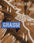 | Details | Anonymous | 1954 |
| Birds-eye view of the French Riviera |
|
Anonymous |
|
| 1954 |
| LOC:88 |
| $195.00 | Anonymous | Birds-eye-view-of-the-French-Riviera | The recto features a highly detailed birds-eye view and map of the French coast, extending from St. Tropez and St. Raphael to Menton. It highlights various towns, such as <b>Grasse, Cannes, Juan-les-Pins, Antibes, Nice, and Monaco</b>. Additionally, it offers a helpful route map that indicates the names and distances of cities along two travel segments for a journey from St. Raphael to Menton:
<br><br>
<div class="indenttextblocksingle">
<ol>
<li>From Nice to St. Raphael via the Corniche de l'Esterel</li>
<li>From Nice to Menton along the Corniches</li>
</ol>
</div>
<div id="0" align="center">
<a title="French Riviera"></a>
<img id="3" src="/ZoomifyImages/SC_4851/SC_4851_detail.jpg" alt="Old birds-eye view and road map of the French Riviera." width="340"/> <br><small>Nice-Cannes-Menton et les routes du littoral.</small>
</div><br>
Although labeled "Ed 54" on the cover, suggesting a publication date of 1954, the included photographs appear to be from the early 1940s. The map's top section displays the names of mountain peaks in the background, and all text is in French.
<br><br>
On the verso, you'll find extra routes, photographs, and descriptions of various sights and attractions. After reviewing the brochure, it's clear that this area is an excellent candidate for a future vacation destination.
<br><br>
Published by France's Direction générale du Tourisme under the Ministry of Public Works, Transport, and Tourism, this edition is identified as "Ed. 54." |
| 4743 | 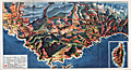 | Details | Societe Nationale des Chemins de Fer Francais | 1950 |
| Attractive map of France's Cote d'Azur |
|
Societe Nationale des Chemins de Fer Francais |
|
| 1950 |
| LOC:77 |
| $80.00 | Societe-Nationale-des-Chemins-de-Fer-Francais | Attractive-map-of-France-s-Cote-d-Azur | Attractive birds-eye view of the coast of the <b>Cote D'Azur</B> in Provence, France stretching from Lyons, France past Monaco. With an inset of the Island of Corsica. Published as a fine folding brochure in 1950 by the Societe Nationale des Chemins de Fer Francais (S.N.C.F.). Red lines represent the railways owned by the French National Railways (SNCF) in in the mid 20th century. |
| 4736 |  | Details | Murphy, John F. | 1915 |
| Birds Eye View of Boston Harbor and South Shore to Provincetown |
|
Murphy, John F. |
|
| 1915 |
| LOC:88 |
| $275.00 | Murphy--John-F- | Birds-Eye-View-of-Boston-Harbor-and-South-Shore-to-Provincetown | ON HOLD
<br><br>A fine, original, early 20th-century folding harbor excursion map of Boston Harbor ready for framing. This fine antique birds-eye view is bright, in great condition with no holes or tears as is common.
<BR> </BR>
Coverage includes South Boston, Nantasket Beach, Hough's Neck, South Bay, Pleasure Bay, Boston Harbor, Dorchester Bay, Quincy Bay, Hingham, Squantum, and Cape Cod Bay to Provincetown. Verso is blank. Index on inside cover with 35 points of interest keyed on the map.
<BR> </BR>
Published by Union News Company , South Station, Boston, Massachusetts. Price is noted on the front cover as "10 cents". Manuscript owner's name on cover, detached but present. |
| 3692 | 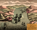 | Details | Homann Heirs | 1743 |
| Scarce antique view of Portobelo, Panama |
|
Homann Heirs |
|
| 1743 |
| LOC:77 |
| $225.00 | Homann-Heirs | Scarce-antique-view-of-Portobelo--Panama | Very scarce birds-eye view of Portobelo, Panama in Colon Province during its capture and destruction in 1739-1742 during the War of Jenkins' Ear. The map depicts the town of Portobelo, Fort Gloria, and the immediate vicinity, including the harbor and Fort Hierro (iron), constructed across the harbor from Portobelo. Several sailing ships depict a naval battle scene and notes in the title block identify and explain sixteen important locations and actions on the view.
<br></br>
Portobelo was founded in March 1597 as "San Felipe de Portobelo". A military compound, Portobelo belonged to a Spain's colonial defensive system, including Veracruz (Mexico), Cartagena (Colombia), and Havana (Cuba), to protect the route of commercial trade between the Americas and Spain. Portobelo, where the annual late summer trade fairs were held, was one of the principal Caribbean ports and played a leading role controlling Spain's imperial trade in the Americas.
<br></br>
Published by the firm Homann Heirs. Homann Heirs (also "Homannianis Heredibus" or "Homann Erben" or "Heritiers de Homann") was a company established after the death of German cartographer J.B. Homann to carry on the map publishing business of the firm he started in the early 1700's. The designation "Homann Heirs" appears on maps published by that successor firm from about 1730 to 1848. |
| 3615 |  | Details | Bodenher, Gabriel | 1704 |
| Attractive antique birds-eye view of the Oresund with Kronborg Castle and Copenhagen |
|
Bodenher, Gabriel |
|
| 1704 |
| LOC:7 |
| $325.00 | Bodenher--Gabriel | Attractive-antique-birds-eye-view-of-the-Oresund-with-Kronborg-Castle-and-Copenhagen | Fine antique birds-eye view of the Oresund, the sound that separates Seeland (Denmark) from Schonen (Sweden). The copperplate-engraved view by Gabriel Bodenher is from the perspective of a viewer looking south into the north entrance of the Oresund. At the right are Helsingor, Kronborg Castle (Cronenburg), and Copenhagen. At left on the east side of the sound lie Helsingborg (Ellingburg), Landskrona (Lands Croon) and Malmo. Warships bearing flags of several nations are underway heading south in the direction of Copenhagen.
<br></br>
Gabriel Bodenher (1673- 1765) was a German map maker and member of a famous family of Augsburg engravers and publishers. Bodenher is best known for his main work, Atlas Curieux, first published in 1704. |
| 2575 | 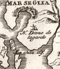 | Details | Coronelli, Vincenzo | 1706 |
| Scarce antique map and plan of Marseilles, France |
|
Coronelli, Vincenzo |
|
| 1706 |
| LOC:77 |
| $275.00 | Coronelli--Vincenzo | Scarce-antique-map-and-plan-of-Marseilles--France | Very scarce map of the Bay of Marseille and surrounding area with a birds-eye view of the city of Marseille, France (Marseglia). Marseilles was the home of France's 'Corps de Galleres' or rowing galleys with lateen-rigged sails. The main fleet of French Navy sailing vessels was headquarted in Toulon, France. The two services were combined in 1744.
<br></br>
Shows a very early view of Marseilles predating the construction and fortification of the town's southern side. In 1660, Louis XIV ensured Marseilles would become the premier commercial port of France in the Mediterranean. Louis commissioned significant new fortifications, and was reported to have said “We noticed that the inhabitants of Marseilles were extremely fond of nice fortresses. We wanted to have our own at the entrance to this great port.”
<br></br>
From "La Francia Divisa in XII Prefetture" , a section of Coronelli's multi-volume "Teatro delle citta e porti principali dell'Europa…" Plate 3 with previous plate number 212. Verso blank |
| 2510 | 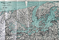 | Details | Puget Sound Navigation Company | 1927 |
| Puget Sound Birdseye View |
|
Puget Sound Navigation Company |
|
| 1927 |
| LOC:0 |
| $300.00 | Puget-Sound-Navigation-Company | Puget-Sound-Birdseye-View | Original 1927 birds-eye view of Puget Sound. This very fine view includes Vancouver, Port Townsend, Bellingham, Seattle, Everett, Puyallup, Tacoma, Olympia, Anacortes, and Guemes Island. North is oriented to the right.
<br></br>
Includes inset map showing major regional highways, and another inset with brief written descriptions of five "Short, enjoyable outings": the Hood Canal country; the Olympic Peninsula country; Vancouver Island; the San Juan Islands; and Whidby Island.
<br></br>
Verso contains information of interest to commuters or vacationers and photos, descriptions, and timetables for numerous local ferries and steamships. Entire brochure unfolds to 29" W x 16" H. |
| 1294 | 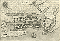 | Details | Bertelli, Pietro | 1599 |
| Early antique birds-eye plan of Valetta, Malta |
|
Bertelli, Pietro |
|
| 1599 |
| LOC:4 |
| $575.00 | Bertelli--Pietro | Early-antique-birds-eye-plan-of-Valetta--Malta | A charmingly detailed birds-eye plan of the area around <b>Valletta, Malta</b> which appeared in the scarce first edition of Pietro Bertelli's "Theatrum Urbium Italicarum", Venice, 1599. Features that Bertelli noted by name on the copper-engraved plan include Malta Citta, Castel di S. Angelo, Castel S. Elmo, Borgo S. Angelo, and Borgo S. Michel. Some experts consider this to be "one the earliest obtainable plans of Malta". With a Maltese-cross cartouche and numerous galleys shown in the harbor.
<br></br>
Produced less than forty years after the Siege of Malta in May 1565, when the Ottoman Empire invaded Malta, then held by the Knights Hospitaller (also known as the Knights of Malta or Knights of Rhodes).
<br></br>
The years leading up to the Siege in 1565 saw the Islands under constant threat from the Ottoman Turks. In 1551, the Ottomans carried out an audacious raid, which saw most of Gozo's population taken into slavery. In 1559, the Knights responded, but with a disastrous attack on Djerba, the Ottoman stronghold on the Tunisian coast.
<br></br>
The Knights knew they were vulnerable in Malta despite the harbours and their two forts, St. Angelo, in what is now Vittoriosa, and newly-built St. Elmo, on the open peninsula of Mount Sciberras overlooking the harbours (later known as Grand Harbour and Marsamxett Harbour). The heroic Knights and Maltese citizens stuggled for many weeks and at the beginning of September, the Ottomans were concerned about having to remain in Malta during the winter, with a long supply-line, and their morale began to fade. Long-awaited relief forces appeared at Mellieħa Bay and the Ottoman troops retreated, but not before losing thousands more men. Today Malta's capital Valetta is named after the Knight's Grand Master Jean de la Valette. (<a href="http://www.visitmalta.com/en/great-siege-1565" target="_blank">Internet</a>) |
| 1144 |  | Details | George W. Walker Lithograph and Publishing Co | 1927 |
| Birds-eye View of Boston Harbor ca. 1927 |
|
George W. Walker Lithograph and Publishing Co |
|
| 1927 |
| LOC:0 |
| $295.00 | George-W--Walker-Lithograph-and-Publishing-Co | Birds-eye-View-of-Boston-Harbor-ca--1927 | Bird's-eye map of Boston Harbor and surrounding region to the east. This folding pocket map is Walker's earliest view of Boston with the new airport, constructed in 1923, that would eventually become Logan International Airport. At far upper right are the yards of the <b>Fore River Ship and Engine Company</b> with two vessels shown under construction.
<br></br>
Numerous steamers, sailboats, and sailing ships are shown underway in the waters offshore Boston, Massachusetts; Winthrop and Spectacle Island. This edition of Walker's map only shows steamer routes for the <b>Nantasket Beach Line Steamers</b> to Nantasket Beach and other points to the east.
<br></br>
The map extends from the coastal area of East and South Boston across the water to the main ship channel and the Boston Light. It locates Winthrop, Thompson's Island, Moon Island, Deer Island, Nahant, Green Island, the Brewster Islands, Strawberry Hill, Fort Warren, Hough's Neck and much more. Several key streets are identified within Boston: Atlantic Avenue, Freeport, Summer Street, Broadway, Dorchester Street, and State Street to name a few.
<br></br>
Copyright Walker Lithograph and Publishing Company, Boston.
<br></br>
Single-color chromolithograph. The bird's eye map folds into manilla board cover titled "Boston Harbor" in manuscript. Map is attached to the cover as issued. Cover apparently made by the seller whose stamp appears on the cover in red ink: "H.A. Shepard and Company. Stationers 50 - 52 Cornhill Boston". Price in manuscript: 15 cents. An unusual find! |
| 1068 |  | Details | Down-East Sportcraft | 1950 |
| Birds-eye View of Casco Bay, Portland, Maine and Surroundings |
|
Down-East Sportcraft |
|
| 1950 |
| LOC:41 |
| $99.00 | Down-East-Sportcraft | Birds-eye-View-of-Casco-Bay--Portland--Maine-and-Surroundings | Large, detailed, panoramic view of coastal Maine north of Portland, including Casco Bay. Neat, 1950's re-print of a view first published by Walker Lithograph at the end of the 19th century, and reproduced in the mid-1950's. This folding birds-eye view highlights dozens of islands, coves, lighthouses, railroad, ferry routes, and other points of nautical interest. Shows the locations of Fort Williams, Portland Head, Fort Preble, Fort Leavitt, Ft. McKinley, Casco Castle, Freeport Landing, and the Portland Yacht Club. Folds to 3 1/2" x 6 1/2".
<br></br>
Named features include Cape Elizabeth, Portland Head light, Cushing Island, Great Diamond Island, Long Island, Great Chebeague Island, Presumpscot River, Mt. Washington, Sebago Lake, Falmouth, Underwood, Harraseeket River, Cousins Island, Bailey's Island, Harpswell Harbor, Merriconeag Sound, Maquoit Bay, Freeport Landing, Brunswick and Lewiston. Routes of the Casco Bay Lines shown in solid black.
<br></br>
Simple, green cardboard cover with blue title printing. |
| 716 | 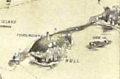 | Details | George W. Walker Lithograph and Publishing Co | 1907 |
| Boston Harbor and the North Shore |
|
George W. Walker Lithograph and Publishing Co |
|
| 1907 |
| LOC:0 |
| $260.00 | George-W--Walker-Lithograph-and-Publishing-Co | Boston-Harbor-and-the-North-Shore | Original antique birdseye view folding map of Boston Harbor by George Walker shows ferry routes, steamer routes and railroad lines between Boston and points both within Boston Harbor and to outlying towns. This fascinating old lithographed map differs from other birdseye-view maps we are aware of from this era because it includes Marblehead, Lynn, Salem and extends north-eastwards to Gloucester, Massachusetts. We can date the map with confidence because it clearly shows the Wonderland Amusement Park at Revere Beach which failed after five years, operating exclusively between 1906 and 1911. Wonderland, served by the Revere Beach and Lynn Railroad, was modeled along the lines of the World's Fairs of that era and included roller coasters, technological exhibits, theaters and a boardwalk.
<br></br>
Noted points of interest include Charlestown, Point of Pines, Magnolia, Baker's Island, Thompson's Island, "the Pumping Station", Dorchester Bay, Squantum, Norfolk Downs, Quincy Bay, Hough's Neck, Hingham Harbor, Winthrop, Beachmont, Great Head, Peddock's Island, Nantasket Beach, Port Allerton, the town of Hull with Fort Revere, George's Island with Fort Warren, Deer Island, Lovell's Island, Lynn, Swampscott, Thatcher's Island, Strawberry Hill, and many more. Captures several local lighthouses and aids to navigation including Boston Light, Long Island Light, Fawn Bar Beacon, Graves Light, and far out the bay - a whistling buoy.
<br></br>
Original lithograph by George W. Walker, lithographer of Boston in landscape format is in very good condition for a 105+ year old map. Was originally folded into a card cover but the front half has disappeared leaving the map attached to the back cover, as issued.
<br></br> |
| 1005 |  | Details | Finn, W.J. | 1917 |
| Birdseye View of Boston Harbor by Union News Co. |
|
Finn, W.J. |
|
| 1917 |
| LOC:200 |
| $240.00 | Finn--W-J- | Birdseye-View-of-Boston-Harbor-by-Union-News-Co- | Folding antique colored harbor excursion map from ca. 1917 of South Boston, Boston Harbor, Dorchester Bay, Quincy Bay, and Cape Cod Bay to Provincetown. This colorful survivor shows steamship routes to coastal towns and identifies many nearby islands.
<br></br>
This map could have been purchased by passengers aboard any steamboat plying the routes shown on the map including:
<div class="indenttextblock">
<ul style="list-style-type: circle;">
<li>To Europe</li>
<li>To Provincetown</li>
<li>To Plymouth</li>
<li>To Nantasket</li>
<li>To New York</li>
</ul>
</div>
Legend at bottom identifies numerous islands and other features as a sample below illustrates:
<div class="indenttextblock">
<ul style="list-style-type: circle;">
<li>Nixes Mate</li>
<li>Snake Island</li>
<li>Commonwealth Pier</li>
<li>Minots Light</li>
<li>Rowes Wharf</li>
</ul>
</div>
Without the advertisements sometimes found on the cover. Price is noted on the front as "10 cents". |
| 50 |  | Details | Kip, Johannes | 1728 |
| Howland Great Dock near Deptford |
|
Kip, Johannes |
|
| 1728 |
| LOC:141 |
| $800.00 | Kip--Johannes | Howland-Great-Dock-near-Deptford | A scarce early 18th century engraved view of the Howland Great Wet Dock (later Greenland Dock) at Rotherhithe, depicting one of the earliest purpose built wet docks in England and a key stage in London's transition from medieval tidal wharfage to enclosed, engineered dock systems. This view has margins > 3 inches. Shown from an elevated birds eye perspective, the composition centers on the rectangular dock basin with its lock entrance to the Thames, where vessels remain afloat at constant water level, a significant technical advance for fitting out, repair, and long term mooring. The surrounding slips, yards, cranes, and ancillary structures are rendered with functional clarity, presenting the dock as modern working infrastructure rather than a picturesque river view.<br><br>
The landscape context is especially revealing. The dock is set amid extensive tree cover and open ground, reflecting the still semi rural character of Rotherhithe in the late 17th and early 18th century. At this date, heavy maritime industry coexisted directly with pasture, orchards, and managed estate land, long before the dense urbanization of the later Georgian docks. The trees are therefore not decorative additions but accurate markers of an early industrial riverside landscape.<br><br>
The wooded setting also had practical importance. Trees stabilized soft riverbank soils and reclaimed ground, and acted as windbreaks for the exposed basin. Their orderly placement reinforces the docks role as a planned improvement, signaling permanence, investment, and control rather than ad hoc industrial growth. Engraved by Johannes Kip, the view combines topographical accuracy with a promotional intent, asserting the technical competence and commercial ambition behind one of London's earliest modern docks.<br><br> |