| | Thumbnail | | Creator | Date | Title / Author / Date / Location | Price | | | Description |
| 1062 | 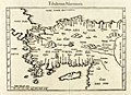 | Details | Fries, Laurent | 1541 |
| Tabula Nova Asiae Minoris |
|
Fries, Laurent |
|
| 1541 |
| LOC:9 |
| $900.00 | Fries--Laurent | Tabula-Nova-Asiae-Minoris | Attractive, scarce, very-early woodcut map of Asia Minor (Turkey, Syria, Iraq) by Laurent Fries. With the islands of Cyprus, Tenedos, Mitilini, Chios, and Rhodes clearly identified. Also easily identified by name are the location of Constantinople, Ephesus, Aleppo, and Damascus.
<br></br>
Published in 1541 in the second edition of Michael Servetus' "Ptolemy 's Geographia", published from Vienna by Gaspar Treschel. This guide to geography, written in the 2nd century A.D. by Claudius Ptolemy, a Greco-Egyptian writer became the standard work until the 16th century, and remained influential in the 18th century, in spite of its inaccuracies. In this edition Servetus makes use of the same maps produced by Laurentius Fries for his 1522 edition of Ptolemy.
<br></br>
Latin text on verso titled: "De Mahometo et Turcarum Origine & Moribus." |
| 358 | 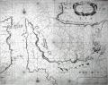 | Details | Levanto, Francesco M. | 1664 |
| Carta Maritima del Golfo di Smirne |
|
Levanto, Francesco M. |
|
| 1664 |
| LOC:8 |
| $1,225.00 | Levanto--Francesco-M- | Carta-Maritima-del-Golfo-di-Smirne | Rare, original antique portolan-style sea chart of east coast of Chios, Greece and the coast of Turkey around Izmir by Genoan cartographer Francesco Maria Levanto. Charming oblique profile depictions of Smirne (Izmir) and Soi (Chios, Greece). Charts of Turkey from the mid 17th century are quite scarce.<BR> </BR>
From Levanto's "La Prima Parte dello Specchio del Mare" (Sea Mirror). Probably based on earlier Dutch charts, possibly influenced by Jacobsz. Place names and notes in Dutch and Italian. With an inset coastal profile and an elaborate decorative cartouche.<BR> </BR>
This chart was reissued about 40 year later by Coronelli. Charts from the Specchio del Mare are quite scarce. |
| 904 | 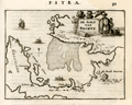 | Details | Dapper, Olfert (Olivier) | 1688 |
| The Gulf of Izmir, Turkey on the Aegean Sea |
|
Dapper, Olfert (Olivier) |
|
| 1688 |
| LOC:2 |
| $170.00 | Dapper--Olfert-(Olivier) | The-Gulf-of-Izmir--Turkey-on-the-Aegean-Sea | Antique copper-plate engraved chart of the Gulf of Izmir (Smyrna or Smyrne) in Turkey from 1688. Coverage includes the Karaburun peninsula ("Calaberno") with windmills depicted at the tip of the peninsula near "C. Calaberno". Moving westward the author depicts and names several settlements including: "Clazomene", "Laberno", "Chipa", and very close to a point of land "Vlakke Punt" lies "Sevafato". The city of Izmir, Turkey is depicted with a small fortress near the coast and a larger fortress in the nearby hill, at present Kadifekale, noted as "Castro Vechio oft Oude Cafteel". Near the present neighborhood of Laka, Dapper identifies a small settlement he calls "Lauro".
<br></br>
The chart is decorated with a square-rigged sailing ship and galleys; in the title cartouche a gentleman in Turkish period attire is shaded by a parasol carried by a servant.
<br></br>
From Olfert Dapper's 1688 edition of his Descripion of the Mediterranean Islands or "Naukeurige beschryving der Eilanden, in de Archipel der Middelantsche Zee, en omtrent dezelve, gelegen: waer onder de voornaemste Cyprus, Rhodus, Kandien, Samos, Scio, Negroponte ...". Dapper was a Dutch writer and self-described physician best known for his books on Africa, China, Persia and Arabia.
<br></br>
Dutch text on verso . Page 91. |
| 1104 | 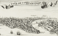 | Details | de Fer, Nicolas | 1705 |
| Veue de la ville et du port de Constantinople |
|
de Fer, Nicolas |
|
| 1705 |
| LOC:0 |
| $0.00 | de-Fer--Nicolas | Veue-de-la-ville-et-du-port-de-Constantinople | SOLD<br></br>
Very detailed and attractive antique engraving of Constantinople or Istanbul, Turkey published from Paris in 1705. Minute detail of all the numerous towers, lighthouses, minarets and mosques that filled the city in the early 18th century.
<br></br>
Two settlements outside the well-fortifed walls are noted: Galata, and on the Anatolian side of the Bosphorous Strait- Scutari, which today is a municipality of Istanbul called Üsküdar. A few hundred meters off the coast of Scutari, on a small rocky islet is pictured the "Tour de Leander" or Maiden's Tower (Turkish: Kız Kulesi) , which over many centuries has served as watchtower, quarrantine station, lighthouse, and defensive structure. Today the tower has been converted into a café and restaurant.
<br></br>
Other named features include the Tower of Belisarius ("Tour de Bellissaire"), le Serail, the Seven Towers ("Les 7 Tours"), le Solimanie, Constantine's Palace, les Magazines de Pera, and Calcedoine.
<br></br>
This antique view was produced by the well known French geographer and cartographer, Nicolas de Fer (1646 - 1720). De Fer was a prolific producer of maps and prints who among other honors, was appointed as official geographer to the Spanish King in 1702. Published in de Fer's atlas: "L'atlas curieux, ou Le monde réprésenté dans des cartes générales et particulières du ciel et de la terre… et orné par des plans et descriptions des villes capitales et principales ...". |
| 867 | 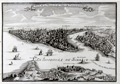 | Details | de Fer, Nicolas | 1705 |
| Birds-eye view of Constantinople or Istanbul, Turkey |
|
de Fer, Nicolas |
|
| 1705 |
| LOC:7 |
| $545.00 | de-Fer--Nicolas | Birds-eye-view-of-Constantinople-or-Istanbul--Turkey | Very detailed and attractive antique engraving of Constantinople or Istanbul, Turkey published from Paris in 1705. Minute detail of all the numerous towers, lighthouses, minarets and mosques that filled the city in the early 18th century.
<br></br>
Two settlements outside the well-fortified walls are noted: Galata, and on the Anatolian side of the Bosporus Strait- Scutari, which today is a municipality of Istanbul called Üsküdar. A few hundred meters off the coast of Scutari, on a small rocky islet is pictured the "Tour de Leander" or Maiden's Tower (Turkish: Kız Kulesi) , which over many centuries has served as watchtower, quarantine station, lighthouse, and defensive structure. Today the tower has been converted into a café and restaurant.
<br></br>
Other named features include the Tower of Belisarius ("Tour de Bellissaire"), le Serail, the Seven Towers ("Les 7 Tours"), le Solimanie, Constantine's Palace, les Magazines de Pera, and Calcedoine.
<br></br>
This antique view was produced by the well known French geographer and cartographer, Nicolas de Fer (1646 - 1720). De Fer was a prolific producer of maps and prints who among other honors, was appointed as official geographer to the Spanish King in 1702. From "L'Atlas Curieux, ou Le monde réprésenté dans des cartes générales et particulières du ciel et de la terre." |
| 528 | 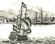 | Details | Anonymous | 1750 |
| Smyrna |
|
Anonymous |
|
| 1750 |
| LOC:2 |
| $350.00 | Anonymous | Smyrna | Original etched view of Smyrna (Izmir) Turkey dating to about the mid 18th century. Foreground depicts European-style warships at anchor. Background shows several forts and a minaret. |
| 3648 | 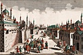 | Details | Probst, Georg Balthasar | 1780 |
| Fine vue d'optique of Constantinople now Istanbul |
|
Probst, Georg Balthasar |
|
| 1780 |
| LOC:88 |
| $375.00 | Probst--Georg-Balthasar | Fine-vue-d-optique-of-Constantinople-now-Istanbul | Fine antique 'vue d'optique' of a street in Constantinople, 'from the Mosque of Mechemet and Selim'. In the foreground is a heavily-guarded caravan of camels. Constantinople, conquered in 1453 by the Ottomans, is today modern Istanbul, Turkey. By Georg B. Probst. Folio No. 54.
<br></br>
This type of print was designed to be looked at through a zograscope, a device designed to give an illusion of depth using mirrors and lenses. The image and title at the top have been transposed left to right. The prints were placed into a view box and the viewers for a small price, could look through a lens to see the print.
<br></br>
Georg Balthasar Probst was the most important member of an Augsburg family of artists and publishers. Probst produced about 400 vue's d'optique on varied subject matter. |
| 1127 | 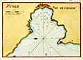 | Details | Roux, Joseph | 1790 |
| Antique harbor plan of Çesme , Turkey |
|
Roux, Joseph |
|
| 1790 |
| LOC:2 |
| $160.00 | Roux--Joseph | Antique-harbor-plan-of-Çesme---Turkey | Antique nautical chart or port plan of the environs around the Bay and village of Çeşme ( Chesme ) Turkey at the far west end of Anatolia near the Çeşme Peninsula. Interestingly, the character "N" in the title "Natolie" is engraved backwards. Çeşme Castle, a 500 year old Ottoman fort is depicted as a walled compound and dominates the east end of the bay. The castle, renovated after the Ottoman-Russian War in 1770, was not used for military purposes after the Crimean War. The castle is is now the Çeşme Archeology Museum.
<BR> </BR>
Çeşme lies in Izmir Province about 50 miles west of the city of Izmir and across a narrow strait from the Greek island of Chios. Çeşme is known as the windsurfing and kite-surfing capital of Turkey, and is considered among the best surfing areas in the world. A few small islands or sandbars, and depth soundings are shown on the map, along with a grove of trees on the north side of the bay.
<BR> </BR>
This small original chart is from a late 18th century edition of the atlas of Mediterranean ports produced by Joseph Roux - "Recueil des Principaux Plans des Ports et Rades de la Mer Méditerranée". Plate 144A.
<BR> </BR>
There were at least four small atlases of port and coastal charts that originated from Marseille hydrographers in the 18th century. Beginning in approximately 1727 these atlases included works by cartographers :
<a rel="nofollow" href= "/MichelotBremondBackground.aspx"> Michelot and Bremond</a>,
<a rel="nofollow" href= "/Creator/Ayrouard--Jacques"> Jacques Ayrouard</a>,
<a rel="nofollow" href= "/Creator/Roux--Joseph"> Joseph Roux</a>
, and Jean Allezard. |
| 5288 | 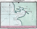 | Details | Luffman, John | 1801 |
| Chart of Iskenderun (Alexandretta) engraved for Luffman's Select Plans |
|
Luffman, John |
|
| 1801 |
| LOC:2 |
| $275.00 | Luffman--John | Chart-of-Iskenderun-(Alexandretta)-engraved-for-Luffman-s-Select-Plans | Harbor chart for Iskenderun (Alexandretta) on Turkey's east Mediterranean Coast. Noted features include: Mount Caillo, Baylassa, Cape Porco, and Cape Canzin.
<br></br>
Description at the bottom reads in part:
<div class="indenttextblock">
"Alexandretta or Scanderoon, a port of Syria at the North Eastern extremity of the Mediterranean Sea, it is the sea port of Aleppo from which city it is distant about seventy miles."
</div>
<br />
From "Luffman's Select Plans of the Principal Cities, Harbors, Forts etc. in the World". Engraved and published by John Luffman, No. 28 Little Bell Alley, Coleman Street, September 1, 1801. Vol II. Number 33.
[ Scanderoon ]. |
| 4780 | 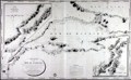 | Details | Depot de la Marine | 1826 |
| Antique Chart Marmara, Dardanelles, Istanbul |
|
Depot de la Marine |
|
| 1826 |
| LOC:66 |
| $2,500.00 | Depot-de-la-Marine | Antique-Chart-Marmara--Dardanelles--Istanbul | Very scarce and wonderfully-engraved French sea chart of the Sea of Marmara, the Dardenelles, Istanbul (Constantinople), the Bosporus, and southern Black Sea from 1826. Depth soundings on this large antique navigational chart extend from the island of Tenedos in the Aegean Sea through the Dardenelles and the Sea of Marmara, up the Bosporus to Istanbul and then into the Black Sea (Mer Noire).
<br></br>
Dedicated to Christophe de Chabrol de Crouzol, Minister of the French Navy from 1824-1829. This supports our date of 1826 though the middle two characters in the date have been effaced leaving only (1--6).
<br></br>
With a large inset chart by Kauffer of the walled city of Constantinople, Turkey and the entire Bosporus and a second inset chart with the Hellespont and Dardenelles by le Comte de Truguet.
<br></br>
<img src="/PageImages/Marmara_Bellin_1772.jpg" alt="Bellin 1772 chart of the Sea of Marmara." width="140" align="left" style="margin: 0px 10px"> No copy of this chart is found online, nor in the AMPR, while 11 sales are recorded of Bellin's earlier "Carte de la Mer de Marmara" at left.
<br></br>
A brief biography in French explains that Etienne Collin, engraver of this work, was the nephew of the renowned Beautemps-Beaupre, considered to be the father of French hydrography. Beautemps-Beaupre practiced an "enlightened nepotism". The biography notes during Beaupre's tenure as Hydrographer "that the functions (geographers, hydrographers, engravers, Cimetiere, ....) within the Depot were largely occupied by members of the Buache-Beautemps-Collin family."
<div class="indenttextblock">
"Etienne Collin (1770, 1841) né à la Neuville-au-Pont. Cousin de Beautemps-Beaupré, il est recruté par le célèbre hydrographe qui pratique un certain népotisme éclairé" ... (Source: http://cartes-martinique.pagesperso-orange.fr/Graveurs_HydroFran.htm)
</div> |