| | Thumbnail | | Creator | Date | Title / Author / Date / Location | Price | | | Description |
| 3651 | 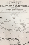 | Details | Imray, James | 1849 |
| Fine gold-rush era blueback chart of California |
|
Imray, James |
|
| 1849 |
| LOC:1409 |
| $3,900.00 | Imray--James | Fine-gold-rush-era-blueback-chart-of-California | California gold-rush era blueback chart of the West Coast from the harbor of San Blas in Mexico heading north past San Francisco Bay. Coverage includes the Gulf of California and the Baja Peninsula. A wide nautical chart in landscape orientation.
<br></br>
Includes six insets and eight stunning coastal views. The insets include: "Entrance of San Francisco Harbour"; "Harbour of San Francisco By Capn. F.W. Beechey R.N. F.R.S."; and "Bay of Monterey By M. de Tessan of the French Navy." Also, Magdalen Bay, Mazatlan, and Guaymas.
<br></br>
Published by James Imray, Chart and Nautical Book Publisher 102, Minories. 1849.
<br></br>
During the 1800's there was a trend toward publication of very large small-scale charts with large-scale insets of key passages and harbors. The practice was driven as much by economics as any other reason. One chart could replace a dozen smaller charts. James Imray and Son was one of a handful of British publishers who specialized in these charts which were often backed with canvas or linen cloth or heavy blue paper in order to help them withstand the frequent use and abuse aboard ship, hence the term "blueback chart". |
| 2559 | 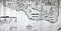 | Details | Laurie, Richard H. | 1870 |
| Huge fine antique blueback General Chart of the Coasts of Brazil |
|
Laurie, Richard H. |
|
| 1870 |
| LOC:1409 |
| $6,800.00 | Laurie--Richard-H- | Huge-fine-antique-blueback-General-Chart-of-the-Coasts-of-Brazil | Huge privately-published blueback chart of Brazil in fine condition. 3' 4" X 6' 4" in total size. Coverage extends from the estuary of the Amazon River in Brazil to the Plate River and Buenos Aires, Argentina. Numerous insets of harbors (eg. Rio de Janeiro, Pernambuco, San Salvador, ...) and elevation coastal views. By Richard H. Laurie. Dated within to 1870 and no later correction or issue dates mean this chart is truly from 1870. Rare, especially in this good condition.
<br></br>
Publishers' attribution at bottom reads: "London, Published by Richd. H. Laurie, No. 53 Fleet Street. January 1st 1870." Engraved by Alex Findlay.
<br></br>
Verso carries labels for both publisher (R.H. Laurie) and seller. Seller is Barber and Bustin, Successors to J.R. Cameron Chronometer, Watch, and Nautical Instrument Maker, 54 South Castle Street, Liverpool.
<br></br>
Note that the image is stitched together from 2 images. Any fuzziness you see near the title center is an artifact of the photo-stitching process. |
| 1476 |  | Details | Eldridge, George W. | 1901 |
| Massachusetts Bay and Coast from Chatham to Gloucester 2 |
|
Eldridge, George W. |
|
| 1901 |
| LOC:0 |
| $300.00 | Eldridge--George-W- | Massachusetts-Bay-and-Coast-from-Chatham-to-Gloucester-2 | Chart D Massachusetts Bay and the Coast from Chatham to Gloucester, published by George W. Eldridge in 1901, is a navigational chart that accurately depicts the coastline, harbors, and navigational hazards along Massachusetts Bay, from Chatham in the south to Gloucester in the north.
<br><br>
The chart is highly detailed and includes information on soundings (water depth measurements), tides, currents, and other navigational data. It shows the location of lighthouses, buoys, beacons, and other aids to navigation, as well as the location of rocks, shoals, and other navigational hazards.
<br><br>
In addition to navigational aids, the chart also shows the names and locations of towns, cities, and other landmarks along the coast, providing a useful reference for sailors navigating the area. Coverage includes the coastal margins near the towns of Provincetown, Truro, Wellfleet, Brewster, Yarmouth, Plymouth, Scituate, Cohasset, Marblehead, Salem, Gloucester, and the town and harbor of Boston, Massachusetts. The chart was designed to be used by sailors and navigators, and its accuracy and level of detail made it an essential tool for safe navigation along the Massachusetts Bay.
<br><br>
Date printed in blue stamp "1901". Note: Price is discounted for condition. |
| 931 |  | Details | James Imray and Son | 1876 |
| Gulf of Mexico New Orleans to Tampico Mexico |
|
James Imray and Son |
|
| 1876 |
| LOC:1409 |
| $4,800.00 | James-Imray-and-Son | Gulf-of-Mexico-New-Orleans-to-Tampico-Mexico | A spectacular, huge (6' foot) antique British privately-published blueback nautical chart of the western Gulf of Mexico in very fine condition. Scarce to find this chart, especially an example kept in such great shape as this one. Chart coverage includes United States coastal areas from New Orleans, Louisiana trending west and then south to Tampico, Mexico. Contains the oval blue inked over-stamp that reads "James Imray and Son, 1876, London."
<br></br>
<b>Note:</b> Because of its large size the photo is stitched together from 2 halves. Some abberations in the image may appear.
<br></br>
This old chart is dotted with numeous inset large-scale charts of key ports and important bays, rivers and harbors including: Galveston, Texas; Atchafalya Bay, Louisiaana, Sabine Pass, Matagorga Bay, Rio Grande, and Tampico, Mexico.
<br></br>
During the 1800's there was a trend toward publication of very large small-scale charts with large-scale insets of key passages and harbors. The practice was adopted as much for economics as any other reason. James Imray and Son was one of a handful of British publishers who specialized in these charts which were often backed with canvas or linen cloth or heavy blue paper in order to help them withstand the frequent use and abuse aboard ship, hence the term "blueback chart".
<br></br>
Outer blue paper contains yellow a large seller's label with the logo of James Imray amd Son.
Price when sold 10 s. |
| 828 |  | Details | James Imray and Son | 1876 |
| Rice Ports of India |
|
James Imray and Son |
|
| 1876 |
| LOC:0 |
| $1,800.00 | James-Imray-and-Son | Rice-Ports-of-India | Privately published blueback chart of the Myanmar ( Burma ) coast including the entire Irawaddy River delta and the Gulf of Martaban. In the 1860's and 1870's as a result of Britain's investment in flood control projects in the Irawaddy River Basin, Burma was transformed into the world's largest rice exporter. This large antique chart would have provided ship owners and sailing masters in the rice trade with a single sheet that offered both small-scale and large-scale navigational information for many of the destinations they sailed from. Inset charts of: Kyouk Phyou, Aracan River, Bassein River, Rangoon River, Bentick Sound and Amherst Road.
<br></br>
Blueback charts are recognizable from the blue paper backing that was attached to a nautical chart to provide the needed strength to withstand hard usage at sea. Published by James Imray and Son, 89 Minories and Tower Hill, London, 1876. James Imray and Sons is one of the firms that over the last two centuries combined to form Imray Laurie Norie & Wilson Ltd.
<br></br>
The following description of the chart was published by Rosser and Imray in the Catalog section of their 1867 "Seaman's Guide" : <div class="indenttextblock">A chart on two large sheets of the coasts of the Bay of Bengal between latitudes 13° and 21° N, longitudes 92° and 98° E. With plans of Akyab, Kyou, Phiouk, Bassein River, Rangoon River, Maulmain, and Kalegouk Island anchorage. A very useful chart for Shipmasters bound to Akyab, Rangoon, or Maulmain as it exhibits the navigation on a larger scale than any hitherto published. (Rosser, William H. and Imray, James F. <b>"The Seaman's Guide to the Navigation of the Indian Ocean and China Sea."</b> <a href="https://books.google.com/books?id=_8BBAAAAIAAJ">Internet</a>. 6/11/2015)
</div>
</br>
Laid to blue paper for protection with cloth selvage. Original cloth map ties. Yellow label from the Imray firm attached on verso. |
| 522 |  | Details | Wilson, Charles | 1877 |
| Blueback Chart of the East and West Coasts of South America |
|
Wilson, Charles |
|
| 1877 |
| LOC:1409 |
| $3,500.00 | Wilson--Charles | Blueback-Chart-of-the-East-and-West-Coasts-of-South-America | Very impressive, enormous, antique blueback sea chart of South America and west coast of the Antarctic Peninsula. We are unaware of any other copy of this chart. Strikingly large (6 ' +) and in excellent condition for 140+ years age. Oriented with North to the right. Drawn by J.S. Hobbs, F.R.G.S. Hydrographer. Insets of 'Magalhaen' Strait, Berkeley Sound and Stanley Harbor, Port of Valdivia, Rio Negro, Cumberland Bay, Port San Carlos, and Concepcion Bay. Numerous inset coastal profile views.
<BR> </BR>
Notable points of interest include Buenos Aires, Argentina, the Falkland Islands (Span. Islas Malvinas), Tierra del Fuego, Patagonia, Port Belgrano, Port Vallego, South Shetland Islands, and Graham Land (the western side of the Antarctic Peninsula named after Sir James R. G. Graham, First Lord of the Admiralty at the time of John Biscoe's exploration in 1832).
<BR> </BR>
With blue paper backing as issued. During the 1800's there was a trend toward publication of very large small-scale charts with large-scale insets of key passages and harbors. This made it possible for mariners to replace perhaps a half-dozen or more charts with just one. The practice was adopted as much for economics as any other reason. Charles Wilson (as the successor to Norie and Company) was one of a handful of British publishers who specialized in these charts which were often backed with canvas or linen cloth or heavy blue paper in order to help them withstand the frequent use and abuse aboard ship, hence the term "blueback chart".
<BR> </BR>
Published by: "Charles Wilson (Late J.W. Norrie and Wilson) at the Navigation Warehouse and Naval Academy, 157 Leadenhall Street." London.
<BR> </BR>
Seller's original red label reads: "River Plate to Valparaiso, including South Shetland Islands. C. Wilson (late Norie and Wilson), 157 Leadenhall St. London, E.C. Price 12 S, 0d." |
| 88 |  | Details | Wilson, Elen | 1937 |
| The Story of the Blueback Chart |
|
Wilson, Elen |
|
| 1937 |
| LOC:2001 |
| $65.00 | Wilson--Elen | The-Story-of-the-Blueback-Chart | Booklet contains a brief history and chronology of the old chart publishing firm of Imray as far back as John Seller and John Senex. Self-published complimentary brochure with softcover and string binding. 20 pages plus illustrations. |
| 23 | 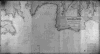 | Details | James Imray and Son | 1868 |
| The Coasts of France, Spain and Portugal (Blueback) |
|
James Imray and Son |
|
| 1868 |
| LOC:0 |
| $750.00 | James-Imray-and-Son | The-Coasts-of-France--Spain-and-Portugal-(Blueback) | Very attractive, imposing, and desirable 140+ year old blueback nautical chart of the Atlantic coast of Europe. Contains the blue stamp from the firm of "Imray 1869". Coverage includes the Strait of Gibraltar and western Mediterranean. This wide antique nautical chart of the West coat of Europe would have been useful to any navigator sailing eastward as it covers all the approaches to the Mediterranean, Bay of Biscay, English Channel and the Bristol and Irish Channels.<BR> </BR>
A six- foot working blueback nautical chart by Imray that has seen its time at sea and exudes history. You can almost smell the salt air! Several manuscript navigator's tracks plotted in pencil include notation: "8th day July 1877 from (illegible) to Falmouth 133 days out". 9 insets including rivers Tagus, Douro and Gironde. Lighthouses indicated in red.<BR> </BR>
On verso is original yellow publishers label from James Imray and Son with price of 10s 6d. Also on verso is a sellers label from "D. Eggert and Sons, manufacturers and importers of chronometers, fine watches, nautical instruments, charts, books, &c. 127 Pearl Street, New York between Wall Street and Old Slip."
<BR> </BR>
For more information on the evolution of blueback charts we recommend this book by Susanna Fisher:
<a target="_blank" style="color:#9BAFCB" href="http://www.regattapress.com/The_Makers_of_the_Blueback_Chart.html">The Makers of Blueback Charts.</a>
<BR> </BR> |