| | Thumbnail | | Creator | Date | Title / Author / Date / Location | Price | | | Description |
| 4845 | 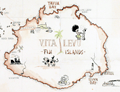 | Details | Anonymous | 1945 |
| WWII MS Cartoon Map of Vita Levu, Fiji Islands |
|
Anonymous |
|
| 1945 |
| LOC:200 |
| $0.00 | Anonymous | WWII-MS-Cartoon-Map-of-Vita-Levu--Fiji-Islands | SOLD<br><br>
Artistically produced manuscript G.I. pictorial map from World War 2 era of Fiji's largest island, Vita Levu. Full of small cartoonish drawings of island life, especially as related to the military with Div. HQ. Suva noted near Suva Bay and Natambua OCS (Officer Candidate School).
<br></br>
Some of the cartoons could suggest a feature in a specific geographic area on Vita Levu but other drawings seem to commemorate group events like a fishing expedition to the nearby Yasawa islands. Viewed as a graphical record of a trip to OCS, the map would document the group's arrival by cargo ship, their overland trip to the OCS by car and then train, passing an airbase; then their arrival and recreation at OCS including swimming and fishing. At mid right a grass-skirted long-haired native offers a G.I. a drink of Fiji's national beverage, Kava.
<br></br>
There was threat of Japanese invasion for the majority of 1942 and part of 1943, which resulted in a build up of military forces and defensive installations. However, World War 2 never reached Vita Levu or any Fijian Island in the South Pacific. In later years, Fiji was used as a forward base for the Allied forces, which resulted in the construction of transportation infrastructure, as well as an influx of Allied troops and supplies coming into the island. Dated as 1945 with the view that fishing expeditions would have been frowned upon in a potential combat theater, thus post-dates WWII. |