| | Thumbnail | | Creator | Date | Title / Author / Date / Location | Price | | | Description |
| 6658 |  | Details | Mount Tamalpais and Muir Woods Railroad | 1923 |
| Birds eye view Map of the Pacific Coast in the vicinity of San Francisco |
|
Mount Tamalpais and Muir Woods Railroad |
|
| 1923 |
| LOC:3 |
| $295.00 | Mount-Tamalpais-and-Muir-Woods-Railroad | Birds-eye-view-Map-of-the-Pacific-Coast-in-the-vicinity-of-San-Francisco | An attractive original antique four-panel bird's eye view / map of the California Pacific coast in the vicinity of San Francisco Bay and San Pablo Bay from 1923.
<br><br>
Elevation is shown in relief. The view stretches from Mount Shasta at top left to the Farallon Islands at the bottom right and extends from Lake Lagunitas at bottom left to Mount Hamilton. Includes towns ranging around San Pablo Bay and San Francisco Bay: San Jose, San Francisco, Palo Alto, Oakland, Sausalito, Napa, Sonoma, and Walnut Creek. At bottom left is a table of air line distances from the summit of Mt. Tamalpais. Sacramento is 73 miles distant and Mt. Shasta a long 237 mile crow-flight from Mt. Tamalpais.
<br><br>
The map comprises four of eight panels of a brochure issued by the Mount Tamalpais and Muir Woods Railroad. Printed by Leighton Press, San Francisco, California. Dated in the plate at 1923. Verso includes photos and text. |
| 6538 |  | Details | Weston, T.W. | 1919 |
| Map of Pinellas County Florida with Fishing Grounds |
|
Weston, T.W. |
|
| 1919 |
| LOC:300 |
| $250.00 | Weston--T-W- | Map-of-Pinellas-County-Florida-with-Fishing-Grounds | Colorful lithographed map (8" x 16") of Pinellas County, Florida in 1919 by T.W. Weston issued in a folding 4" x 9" brochure by the Pinellas County Board of Trade. In addition to the Pinellas County map, the brochure includes a fine small oblique birds-eye view - "Dunedin - a typical coast town" (Fig 1.), a small regional distance chart extending for 1500 miles from Pinellas County (Fig 2.), descriptive text, and numerous photographs. <br><br>
<div id="1" align="center">
<a title="Dunedin, Florida Birds-eye View"></a>
<img id="1" src="/ZoomifyImages/SC_6538/SC_6538_Detail1.jpg" alt="Dunedin, Florida 1919 Birds-eye View" width="320"/> <br><small>Fig. 1 - 1919 Birds-eye View of Dunedin, Florida.</small>
</div><br>
The Pinellas County map shows soil type (coastal beach, Parkwood loam, tidal marsh …) indicated by color overlaid with routes of steam railroads, electric railways, three types of roads, canals, and drainage districts.
<br><br>
<div id="2" align="center">
<a title="Pinellas County Distance Chart"></a>
<img id="2" src="/ZoomifyImages/SC_6538/SC_6538_Detail2.jpg" alt="Distance chart related to Pinellas County Florida." width="250"/> <br><small>Fig. 2 - Statute mile distances from Pinellas County.</small>
</div><br>
Red font denotes species of fish found around Pinellas County (Fig. 3) These fish include tarpon, trout, channel bass (redfish), mackerel, and kingfish.<br><br>
<div id="3" align="center">
<a title="Pinellas County Fish Species"></a>
<img id="3" src="/ZoomifyImages/SC_6538/SC_6538_Detail3.jpg" alt="Detail from Pinellas County Map." width="250"/> <br><small>Fig. 3 - Detail of Pinellas County fish species.</small>
</div> |
| 6513 |  | Details | Page, Peter Hugh | 1940 |
| Fine second edition pictorial map of Stanley Park, Vancouver, British Columbia, Canada |
|
Page, Peter Hugh |
|
| 1940 |
| LOC:78 |
| $350.00 | Page--Peter-Hugh | Fine-second-edition-pictorial-map-of-Stanley-Park--Vancouver--British-Columbia--Canada | Beautiful lithographed pictorial map of Stanley Park, Vancouver, Canada by Peter Hugh Page, ca. 1940. Excellent condition. Second Edition. Shows Prospect Point, Brockton Point, Deadman's Island, Lost Lagoon, Second Beach, Beaver Lake and many other locations and attractions in Stanley Park.
<br><br>
<div align="center">
<a title="Stanley Park Cover"></a>
<img id="3" src="/ZoomifyImages/SC_6513/SC_6513_detail.jpg" alt="Cover from a brochure on Stanley Park, Vancouver, Canada by Peter Hugh Page in 1940." width="175"/> <br><small>Cover from Page's map of Stanley Park</small>
</div><br>
The second edition of Page's map of Stanley Park differs from the first edition in that it includes a depiction of the Lion's Gate Bridge (built 1939) and the label for Siwash Rock is removed. Verso with text about Stanley Park. |
| 6478 |  | Details | Boyle, Stuart | 1931 |
| Elegant lithographed pictorial map of the Cape Peninsula South Africa |
|
Boyle, Stuart |
|
| 1931 |
| LOC:14 |
| $550.00 | Boyle--Stuart | Elegant-lithographed-pictorial-map-of-the-Cape-Peninsula-South-Africa | Lovely, original pictorial map of the Cape Peninsula in South Africa by illustrator Stuart Boyle. Stuart Boyle illustrated several books including Evelyn Waugh’s The Loved One.
<br><br>
This fine map of the Cape Peninsula is characterized by elegant, colorful design and superb execution, with locations, notes, and literary quotes identified in scrollwork captions. These include:
<div class="indenttextblocksingle">
<ul style="list-style-type: circle;"></li>
<li>For the seas call and the stars call, and oh! the call of the sky- G. Gould.</li>
<li>White as sand of Muizenberg spun before the gale - Kipling.</li>
<li>Under hot Constantia broad the vineyards lie - Kipling</li>
<li>Good bathing to be had here.</li>
<li>Some say this drive in unequalled anywhere.</li>
<li>Fish simply ask to be caught here.</li>
<li>These are the twelve apostles</li>
</ul>
</div>
Only three holdings of this 1931 pictorial map are identified in WorldCat. No copies currently for sale were located.
<br><br>
Verso with text and numerous photogravure images of locations around the Cape Peninsula.
<br><br>
Issued by the Cape Peninsula Publicity Association and the South African Railways and Harbours Administration in 1931. Printed by the Cape Times. |
| 6425 |  | Details | Hope Mining, Milling, and Leasing Company | 1912 |
| Aspen Colorado Hope Mining Lease Map Brochure |
|
Hope Mining, Milling, and Leasing Company |
|
| 1912 |
| LOC: |
| $625.00 | Hope-Mining--Milling--and-Leasing-Company | Aspen-Colorado-Hope-Mining-Lease-Map-Brochure | Map of the property of the Hope Mining, Milling, and Leasing Company of Aspen, Colorado ca. 1912. An optimistic four-panel folding promotional brochure designed for potential investors. The Hope mine lies about four miles due south of the town of Aspen, Colorado at an altitude of 10,259 feet. The map is found on the verso flanked by two striking full-panel images of local mountainous mining scenes in a style somewhat similar to a wood-block print. The verso will make a very-attractive presentation when framed.
<br><br>
The recto contains three photographic images of the Aspen, Colorado area and of the Hope mine:
<div class="indenttextblocksingle">
<ul style="list-style-type: circle;"></li>
<li><i>"Aspen, The Crystal City of the Rockies"</i></li>
<li><i>"Portal of the Tunnel"</i></li>
<li>A larger two-panel image with the caption: <i>"You are looking at the power plant in the foreground. The boarding house is on the hillside in the rear. The winding road leads down to Castle Creek which will be the source of our hydro-electric power when we "strike" it."</i></li>
</ul>
</div>
Folded 4" x 9". Unfolded 14" x 8 within the neatlines.
<br><br>
In October 1911 the Crystal City (Aspen, Colorado) Boosters Association organized a local mining company the "Hope Mining, Milling, and Leasing Company" with initial capitalization of $50,000. The Association secured ten-year leases on the Little Annie Group of Mines, the Little Annie Tunnel, and the Famous Tunnel. [1]
<br><br>
[1] "Hope Mining, Milling, and Leasing Company: Read and 'Get Wise' to what the Crystal City Boosters are doing for Aspen and the 'Get In' the bandwagon and boost." The Aspen Democrat-Times. Aspen, CO. March 6, 1912. |
| 6340 |  | Details | Johnson, W.R. | 1955 |
| Plan of the Atomic Tunnel 1950's attraction near Daytona Beach |
|
Johnson, W.R. |
|
| 1955 |
| LOC:11 |
| $199.00 | Johnson--W-R- | Plan-of-the-Atomic-Tunnel-1950-s-attraction-near-Daytona-Beach | Lithographed plan / view of the <i>"World's Most Unusual</i> Atomic Tunnel". A four-panel <strong>Florida roadside-attraction</strong> brochure from the early 1950s. An atomic age wonder! The illustrator is unknown but his interpretation of Happy the Walking Fish is a high point in mid-century illustration with Happy dressed to the nines in bow tie, top hat, and tuxedo and carrying a cane.
<div class="indenttextblocksingle">
" … it was a long, white concrete building in the shape of a meandering tube, studded with 824 "port holes" (variously shaped small windows) that was designed primarily as a showcase and shop for exotic orchids. It also featured tropical birds, a monkey, and "Happy, the walking fish," a typical Southeast Asian "walking" catfish that could be prodded into flipping its way across a short dry connection from one tank to another." (1)
</div>
<BR />
<div id="1" align="center">
<a title="Atomic Tunnel">
<img id="TunnelPlan" src="/ZoomifyImages/SC_6340/SC_6340_Happy_400x300.jpg" alt="Atomic Tunnel" width="240"
/>
</a>
</div>
<div id="2" align="center">
<a title="Atomic Tunnel">
<img id="TunnelPlan" src="/ZoomifyImages/SC_6340/SC_6340_400x300.jpg" alt="Atomic Tunnel" width="300"
/>
</a>
</div>
<br />
<u>Verso</u> contains two reverse-profile portraits of "Happy, the Walking Fish" and also two fold-in panels showing a map and plan of the Atomic Tunnel with happy visitors strolling along walkways. The illustrator cleverly uses two different levels of scale on this work, at top a linear representation with mile boards of HWY 1 stretching from Daytona Beach, Florida through Port Orange to the Atomic Tunnel and below on the same page a plan view of the Atomic Tunnel's tunnels, rooms and walkways at a large scale. The <u>recto</u> shows detailed photographs of the rooms including the Fish room, Bird room and Cactus room. |
| 5493 | 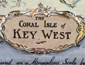 | Details | Dornbush, Adrian | 1935 |
| Public Works of Art Project brochure variant 2nd Edition map Coral Isle of Key West |
|
Dornbush, Adrian |
|
| 1935 |
| LOC:500 |
| $285.00 | Dornbush--Adrian | Public-Works-of-Art-Project-brochure-variant-2nd-Edition-map-Coral-Isle-of-Key-West | Two scarce maps including a rare presumed 2nd. "The Coral Isle of Key West" Florida in a visitor's guide booklet simply titled "Key West" published by the Key West Administration after 1935. The booklet is a product of the Public Works of Art Project (PWAP) during the New Deal that was succeeded by the Federal Art Project of the Works Progress Administration (WPA).
<div class="indenttextblocksingle">
"Public Works of Art Project artists from other parts of the country were brought in and put to work creating paintings, murals or public places, and other projects, such as tourist brochures and postcards." [1]
</div><br>
<div id="3" align="center">
<a title="Key West Booklet"></a>
<img id="3" src="/ZoomifyImages/SC_5493/SC_5493_Cover_400x300.jpg" alt="Dornbush pictorial map The Coral Isle of Key West." width="240"/>
</div>
<br />
Other FERA artists who contributed works to the brochure include Edward Bruce, Richard Sargeant, Avery Johnson, Klir Beck, and Richard Jansen.<br>
</br>
The brochure includes a fine 9" x 6" pictorial map of Key West, Florida: "The Coral Isle of Key West" by artist Adrian Dornbush, 1935. Second edition. This map is most interesting in that it is an <b>unrecorded substantial revision of Dornbush's original map of Key West.</b> This edition contains numerous changes from the first edition including:
<div class="indenttextblocksingle">
<ul>
<li>For the first time, an airport is noted in the location of Meacham Field, now Key West International Airport (EYW)</li>
<li>Seaplane ramps at Trumbull Point (labeled "Key West Airways") are replaced with ship docks. </li>
<li>Radio towers are now shown located at the island's west side near Duval Street.</li>
</ul>
</div>
The map was engraved on a "miraculous" scale and shows key landmarks such as Duval Street, the lighthouse, the Martello Towers, and the yacht basin.
<br></br> |
| 5392 | 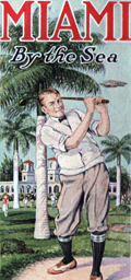 | Details | Miami Chamber of Commerce | 1923 |
| Advertising Brochure for Miami, Florida Winter Tourist Season |
|
Miami Chamber of Commerce |
|
| 1923 |
| LOC:11 |
| $235.00 | Miami-Chamber-of-Commerce | Advertising-Brochure-for-Miami--Florida-Winter-Tourist-Season | Folding brochure from the Miami Chamber of Commerce, published in 1923, for the Miami, Florida winter tourist season, November to May. <br></br>
With two maps, each 8" x 9":
<div class="indenttextblocksingle">
<ul style="list-style-type: circle;">
<li>"Miami in the Tropical Zone of Florida. Where Winter is Turned to Summer."</li>
<li>"Greater Miami and Vicinity</li>
</div>
The brochure Includes a 30" long foldout page covered with photographs of Miami Hotels and Miami area attractions and numerous pages with test and photographs surrounded by colorful scenes of Miami, Florida leisure activities.
<br></br>
An inset text block on the second page summarizes Miami's winter attractions:<br>
<strong>MIAMI in the Tropical Zone of Florida where winter is turned to summer.</strong>
<div class="indenttextblocksingle">
<ul style="list-style-type: circle;">
<li>The Tourist's Delight</li>
<li>The Motorist's Mecca</li>
<li>The Fisherman's Paradise</li>
<li>The Golfer's Wonderland</li>
<li>The Polo-player's Pride</li>
<li>The Surf-bather's Joy</li>
<li>The Aviator's Dreamland</li>
<li>The Yachtsman's Rendezvous</li>
</ul>
</div>
Copyright 1923, Miami Chamber of Commerce. Designed, engraved and printed by the Record Company. St. Augustine, Florida. Folds to 4" x 9". |
| 5386 | 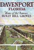 | Details | Holly Hill Grove and Fruit Company | 1923 |
| Fine brochure for Holly Hill Groves Davenport Florida with maps and views |
|
Holly Hill Grove and Fruit Company |
|
| 1923 |
| LOC:11 |
| $240.00 | Holly-Hill-Grove-and-Fruit-Company | Fine-brochure-for-Holly-Hill-Groves-Davenport-Florida-with-maps-and-views | Fine brochure for Holly Hill Groves in Davenport, Polk County, Florida with a map, views, and numerous 2-color photographs.
<br>
<div class="indenttextblocksingle">1) A colorful view titled "<b>Diagram of Holly Hills Groves</b>" . With an inset view "A Five Acre Grove". 18" W x 6.5" H.<br>
2) An index or context map shows the location of Davenport, Florida in the center of the state. "<b>Map of Florida Showing Location of Davenport and Polk County."</b> 6.5" W x 9" H.</div>
Photos are of the orange groves in various states of completion as well as of the Holly Grove Inn, located along the Dixie Highway. Published during the early 1920's during Florida's real estate boom.
<br></br>
The Holly Hill Grove and Fruit Company, with over 5,000 acres, was a subsidiary of Wilson and Toomer Fertilizer Company, owned by Lorenzo A. Wilson. The brochure was published as a marketing tool to promote sales of five-acre plots of the grove. <br></br>
32 pages. Soft covers. Folds to 5" W x 7" H. Printed by The Record Company, St. Augustine, Florida.
<br></br> |
| 5387 | 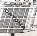 | Details | Simpson and Pope | 1925 |
| Map and marketing brochure for Ortona, Florida |
|
Simpson and Pope |
|
| 1925 |
| LOC:11 |
| $150.00 | Simpson-and-Pope | Map-and-marketing-brochure-for-Ortona--Florida | Scarce sales brochure ca. 1925 for the Ortona, Florida development located on Florida's east coast in Volusia County just south of Ormond, Florida. Cover of the brochure shows several cottages and bungalows built in the Ortona neighborhood in the early 1920's. Note: this location is NOT the town of Ortona, Florida in Glades County.
<br></br>
The map shows Ortona bounded at the west by the Halifax River and at the east by the [Daytona] Auto Race Course on the beach. To the south, in 1925 Ortona was bounded by the "Clarendon Golf Links" and Seabreeze. The towns of Seabreeze, Daytona Beach, and Daytona are shown as platted and developed.
<br></br>
TITLE: "Ortona, On the Finest Ocean Beach in America, For Your Winter Home". Single sheet, folded. |
| 5375 | 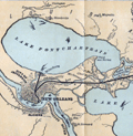 | Details | Louisville and Nashville Railroad | 1886 |
| Birds Eye View of Gulf Coast Louisville and Nashville Railroad |
|
Louisville and Nashville Railroad |
|
| 1886 |
| LOC: |
| $725.00 | Louisville-and-Nashville-Railroad | Birds-Eye-View-of-Gulf-Coast-Louisville-and-Nashville-Railroad | </br>"The Great Through Car Line Between the North and South."</br>
"Unrivaled in Speed, Construction and Equipment."
<br></br>
Fine bird's eye view of the central Gulf Coast highlighting the route of the Louisville and Nashville Railroad from Mobile, Alabama, through Mississippi, to New Orleans, Louisiana. The route includes Bay St. Louis, Ocean Springs, Pass Christian, Mississippi City, Biloxi, Pascagoula. Numerous steam-powered and wind-powered vessels are shown plying the waters of the Gulf of Mexico, Lake Ponchartrain and the Mississippi River.
<br></br>
Six-panel folding map, neatly folded inside a 64-page pamphlet (4.5 " x 7.25") titled "The Gulf Coast". With the ink stamp of Sam. B. Jones, General Agent, New York. Published by the passenger department of the Louisville and Nashville R.R.
<br></br>
Printed in Louisville, KY by the Press of the Courier-Journal Job Printing Company. |
| 5255 |  | Details | Anonymous | 1958 |
| Pictorial Map of Sanlando Springs attraction near Longwood, Florida |
|
Anonymous |
|
| 1958 |
| LOC: |
| $125.00 | Anonymous | Pictorial-Map-of-Sanlando-Springs-attraction-near-Longwood--Florida | Colorful pictorial map of the Sanlando Springs tourist attraction in Central Florida. Map is surrounded with drawings of family-oriented activities available at Sanlando: Jungle Cruise, outdoor cooking, dancing on the patio. Based on the postal rate of 3 cents this item probably dates to the late 1950's. Folding map, verso with space for a stamp and address as well as a pre-written letter in script touting the many things to do at Sanlando.
<br></br>
Sanlando Springs, along with nearby Rock Springs, Wekiwa Springs and Palm Springs, form the headwaters of the Wekiva River.
<br></br>
The spring, originally Hoosier Springs, was used for recreation as far back as the 1880's. The location was renamed as Sanlando by Altamonte Mayor J.F. Haithcox who developed the location as an amusement park in the 1920's. (Source: https://studiohourglass.blogspot.com/2013/06/giving-new-life-to-sanlando-springs.html). |
| 5256 | 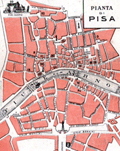 | Details | Jonni, G. | 1915 |
| Pianta di Pisa |
|
Jonni, G. |
|
| 1915 |
| LOC:14 |
| $75.00 | Jonni--G- | Pianta-di-Pisa | Map of Pisa, Italy for Jonni's Grand Hotel Minerva ca 1915. Located on verso of a folding trade card for the hotel. No phone number, but electric lights … estimated ca. 1915 when adoption rates for the telephone in Italy were about 5% of the rate in the U.S.A. |
| 5208 |  | Details | Astor, William Waldorf | 1922 |
| Maps and auction brochure for Bronx property of William Waldorf Astor |
|
Astor, William Waldorf |
|
| 1922 |
| LOC:88 |
| $1,250.00 | Astor--William-Waldorf | Maps-and-auction-brochure-for-Bronx-property-of-William-Waldorf-Astor | Very rare sales brochure for an auction of a tract of 1669 lots owned by <b>William Waldorf Astor</b> located in the Morris Park area of the Bronx in New York City. Rare- only one other holding located anywhere, an inferior example held by the New York Public Library. Astor died of heart failure in October, 1919 and the auction documented in these artifacts was held to settle Astor's estate less than three years later, in June, 1922.
<br></br>
Brochure (11" x15") includes a fine bird's eye view on the front cover; a map of a portion of New York City with the Bronx showing the tract location in context to subways and roads on the back cover; and a folding plat map enclosed within with lots platted shown on both sides of a large sheet measuring 21" x 30". All in good to very good condition. (Images of the folding plat map are available on request.)
<br></br>
William Waldorf Astor (1848-1919), was the only child of John Jacob Astor III, an attorney, politician, philanthropist, and newspaper publisher. W.W. Astor's great-grandfather father, John Jacob Astor, made a fortune in the fur trade and was the wealthiest man in the U.S. in 1848. |
| 5136 | 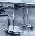 | Details | Seaboard Air Line Railway | 1904 |
| Antique Panoramic View of Havana Cuba |
|
Seaboard Air Line Railway |
|
| 1904 |
| LOC:51 |
| $550.00 | Seaboard-Air-Line-Railway | Antique-Panoramic-View-of-Havana-Cuba | Antique folding half-tone panoramic view of Havana, Cuba (1904) titled "Havana Harbor and City." A very fine view from a brochure by the Seaboard Air Line Railway "Cuba" promoting the route of the Peninsular and Occidental Steamship Company's steamship from Port Tampa to Key West, Florida to Havana.
<br></br>
A drawing, resembling a photograph, showing a panoramic view taken from the perspective of La Cabaña, (Fortaleza de San Carlos de la Cabaña). At upper right the view shows Morro Castle and lighthouse at the entrance to Havana Bay. Across the bay, the city of Havana shines, while sailing vessels and steam powered ships ply the waters of the bay. A reviewer of the period described the work as:
<div class="indenttextblocksingle">
<ul style="list-style-type: circle;">
… a panoramic view of Havana Harbor and City superbly reproduced in half-tone, the sky and water effects being especially meritorious, showing skillful overlay and press-work." [1].
</ul>
</div>
Brochure printed by Edgell Press. Cover to brochure included.
<BR></BR>
[1] Ryan, Charles B. Transportation. January 1904. No. 1. p. 29. |
| 5124 | 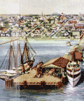 | Details | Straub, W.L. | 1917 |
| Antique airplane views of St. Petersburg Florida |
|
Straub, W.L. |
|
| 1917 |
| LOC:11 |
| $400.00 | Straub--W-L- | Antique-airplane-views-of-St--Petersburg-Florida | Brochure with maps and scarce airplane views of St. Petersburg, Florida including a fine oblique elevated view of the harbor: "St. Petersburg, the Place 'of Proved Desire and Known Delight' " by artist W.L. Straub (15" x 6"). Found at the center of a six-panel folding brochure- "St. Petersburg Florida, The Sunshine City Issued by the St. Petersburg Board of Trade."
<br></br>
Along with numerous smaller illustrations and photographs the brochure includes additionally two fine views and two maps:
<div class="indenttextblocksingle">
<ul style="list-style-type: circle;">
<li>View of the "mole", the "spa", the municipal pier and bathing beaches</li>
<li>Panoramic view of St. Petersburg, Fla. from the Plaza Theater (by Van Deventer & Sons 1913.</li>
<li>Map showing location of St. Petersburg Florida with Railroad and Steamship Connections.</li>
<li>Map of Pinellas County, Florida showing location of St. Petersburg "The Sunshine City".</li>
Brochure folds to 9" x 4". |
| 5109 | 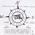 | Details | Winter Park Board of Realtors | 1951 |
| Mid-century map of Winter Park Florida |
|
Winter Park Board of Realtors |
|
| 1951 |
| LOC:87 |
| $115.00 | Winter-Park-Board-of-Realtors | Mid-century-map-of-Winter-Park-Florida | Map of the city of Winter Park, Florida and vicinity published by the Winter Park Board of Realtors (1952) in a 12-panel folding format. Lakes shown boldly in green. Key at bottom left with road reference locations in Orlando, Eatonville, Maitland, and Winter Park. One section of road highlighted in red. Small manuscript notation in pencil.
<br></br>
Verso titled "Maps and facts about Winter Park Florida <b>City of Homes</b>." Full of text and photographs related to Winter Park, particularly to Rollins College and to the history behind Winter Park's appellation as the "City of Homes." With logo for the National Association of Real Estate Boards at bottom right. Border with alpha-numeric location index indicators.
<br></br>
Shows more than a dozen lakes of all sizes including Lake Fairview, Lake Killarney, Lake Maitland, Lake Osceola, Lake Corrine, and Lake Rowena.
<br></br>
Copyright 1952 by James T. Ellis. Interesting compass rose style unknown logo by Ellis' name. |
| 5114 | 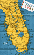 | Details | Poole Brothers, Inc. | 1935 |
| Map Dixie Route rail service to Florida |
|
Poole Brothers, Inc. |
|
| 1935 |
| LOC:11 |
| $200.00 | Poole-Brothers--Inc- | Map-Dixie-Route-rail-service-to-Florida | Map (8" x 15") within a twenty-two page folding brochure for <b>The Dixie Route</b>, a train service that in 1939 operated three passenger trains across several affiliated railroads and their stops to provide passenger service from the Midwest (St. Louis and Chicago) to Florida. The railway companies contributing to the brochure included:
<div class="indenttextblocksingle">
<ul style="list-style-type: circle;">
<li>Chicago and Eastern Illinois Railway</li>
<li>Louisville and Nashville Railroad</li>
<li>Nashville, Chattanooga, and St. Louis R.Y</li>
</ul></div>
Daily Dixie Route trains to Florida were The Dixieland (with overnight service to Florida) , The Dixie Flyer, and The Dixie Limited.
<br></br>
Copyright 1935 by publishers Poole Brothers, Inc. Published October 1939 (dated within).
<div class="indenttextblocksingle">
Poole Brothers was a publishing company founded in 1870 by George Amos and William H. Poole. The company was the largest printing house in the country that catered to transportation companies. According to The Inland Printer, "practically every railroad in the country used Poole Brothers materials." [1] </div>
</br>
[1] Source: https://en.wikipedia.org/wiki/Poole_Brothers |
| 5087 | 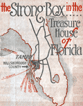 | Details | Tampa Board of Trade | 1923 |
| Tampa the Strong Box in the Treasure House of Florida |
|
Tampa Board of Trade |
|
| 1923 |
| LOC:11 |
| $250.00 | Tampa-Board-of-Trade | Tampa-the-Strong-Box-in-the-Treasure-House-of-Florida | Pre-depression advertising map promoting Tampa and Hillsborough County as: "The Strong Box in the Treasure House of Florida". Beneath the map an explanation describes the benefits to be found in Hillsborough County:
<div class="indenttextblock">
"Containing lands, rich and of infinite variety, adapted for fruit raising, agriculture in all its phases, trucking, poultry farming, stock raising, and all those novelty lines for which Florida is famous. The marketplace of practically all of South and West Coast Peninsular Florida, with over fifty miles of salt water shoreline. Look us over."
</div>
Unusual and scarce. 1923.
<br></br>
Map image with strong graphics is inside the front cover of 44-page brochure ( 9" x 6") about Tampa, Florida. Brochure wraps covered with images of local leisure activities for Tampa (front) and Hillsboro County (rear). On both covers images of bi-planes cruising aloft attest to the importance of Tampa, Florida as an early aviation center. |
| 5057 | 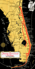 | Details | Florida East Coast Railway | 1933 |
| Map of Florida East Coast Railway the St. Augustine Route |
|
Florida East Coast Railway |
|
| 1933 |
| LOC:200 |
| $250.00 | Florida-East-Coast-Railway | Map-of-Florida-East-Coast-Railway-the-St--Augustine-Route | Colorful folding map of Henry Flagler's Florida East Coast Railway, the St. Augustine Route. Includes the Key West extension and the route from Key West to Havana, Cuba of the Peninsular and Occidental Steamship Company.
<br></br>
Interesting and seemingly out-of-place notations for two fishing camps on the Keys: Pirates Cove fishing camp and Long Key fishing camp. Printed by the Record Company, St. Augustine, Florida. Map is in the center of a folding brochure of 15 pages. |
| 5056 |  | Details | Anonymous | 1960 |
| Map Seven Seas Sightseeing Miami and Miami Beach Cruise |
|
Anonymous |
|
| 1960 |
| LOC:11 |
| $85.00 | Anonymous | Map-Seven-Seas-Sightseeing-Miami-and-Miami-Beach-Cruise | Brochure for a 2.5 hour lectured cruise of North Biscayne Bay, Miami Beach, Florida aboard the double-decked motorboat Seven Seas. With a map of the cruise route (in red) around North Biscayne Bay.
<br></br>
Unlike other cruises on south Biscayne Bay (e.g. Uncle Sam cruise) the Seven Seas cruise was operated in<b> North Biscayne Bay</b>, departing from Pier 8 at the Miami City Yacht Basin twice daily. The cruise passed the Venetian Causeway, passed the Charles Deering estate, and sailed past the 79th street causeway, retiring past Mt. Sinai Hospital and making a circle in Sunset Lake before docking 2 1/2 hours later. Other points of interest included the Goodyear Blimp Base, Flagler Memorial Monument, Little River, and Indian Creek Village.
<br></br>
Printed on both sides and folds to 4" x 9". |
| 5054 | 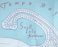 | Details | Green, John B. | 1951 |
| Map brochure for Brightwaters Snell Isle Harbour St. Petersburg Florida |
|
Green, John B. |
|
| 1951 |
| LOC:87 |
| $400.00 | Green--John-B- | Map-brochure-for-Brightwaters-Snell-Isle-Harbour-St--Petersburg-Florida | Scarce original plat map of <b>Snell Isle Harbor</b> in St. Petersburg, Florida ca. 1951, by John B. Green, a local realtor. Includes red manuscript notes about lots previously sold. With an inset photograph of the area surrounding Brightwaters Snell Isle. Shows the outline of property for Clark's Sunset Golf Course and a block reserved as a business center. North is oriented to left bottom. Plat includes Snell Isle Boulevard, Cordova Boulevard, Toledo Way, Miramar Blvd., and Brightwaters Boulevard. Verso with information and a fine bird's eye view of the planned development.
<br></br>
Now one of St. Petersburg’s most upscale and desirable neighborhoods, Snell Isle was once nothing more than a low-lying mangrove swamp. When C. Perry Snell, a Kentucky pharmacist, came to visit the area in 1899, he envisioned a residential waterfront enclave and invested in the property of what is now Coffee Pot Bayou and Snell Island. In 1911, he began developing Snell Island.
<br></br>
In 1926, Snell opened the Coffee Pot Bayou Golf Club, now the 18-hole Vinoy Renaissance Resort Golf Club on Snell Isle. A few years later in 1928, he gifted land to the St. Petersburg Woman’s Club which still stands today on Coffee Pot Bayou and is on the U.S. Register of National Historic Places.
<br></br>
Snell Isle is completely residential, with several apartment communities, two schools, and two churches. Many original homes from the 1920s still exist today, with charming European and Spanish architecture. More than 80 percent of homes on Snell Isle enjoy waterfront views, some of the Bay and others on interconnected waterways. |
| 5052 |  | Details | Rice, George T. | 1931 |
| Map of Key West Florida |
|
Rice, George T. |
|
| 1931 |
| LOC:11 |
| $250.00 | Rice--George-T- | Map-of-Key-West-Florida | Scarce map of Key West Florida in booklet "Fifth Annual Tourists Sight Seeing Guide of Key West Florida 1933 Courtesy of Key West Business People". Locations identified numerically on the map appear not to correspond to numbered locations in the booklet. It is informative to compare this map with a very similar sightseeing map (1945-1948) in the Touchton Map Library. Numerous changes to Key West related to WWII are apparent, especially the construction of Meacham Field.
<br></br>
Booklet 3.5" x 7" with advertisements for local Key West businesses including: The Artman Press, The Key West Citizen, Gardner's Pharmacy, Columbia Laundry, The Key West Colonial Hotel and more. With a list of facts about Key West and a description of a tour of local sights including the "turtle crawls":
<div class="indenttextblocksingle">
"3. Visit the turtle crawls where turtles weighing over two hundred pounds may be seen swimming by dozens in pens while waiting to be slaughtered. Turtles have been caught near Key West weighing over one thousand pounds. This is a sight to remember. Located: Dock at North end of Margaret street."
</div></br>
The map was compiled under the direction of George T. Rice, Captain 13th C.A. (Coast Artillery). Drawn by A.D. Shirk, Staff Sergeant, 13th C.A. July 10, 1931. |
| 5053 |  | Details | Anonymous | 1918 |
| Two manuscript maps of St. Augustine, Florida and of the area. |
|
Anonymous |
|
| 1918 |
| LOC:11 |
| $400.00 | Anonymous | Two-manuscript-maps-of-St--Augustine--Florida-and-of-the-area- | Two manuscript maps on a single sheet inserted into a tourism brochure of St. Augustine, Florida after printing. Unusual. Maps show St. Augustine at street-level detail and on verso a smaller-scale map of the area surrounding St. Augustine. Type-written text on one map sheet indicates re-use of a telephone service remittance document for creation of the map. The small scale map of the area around St. Augustine appears only to consider railway lines (F.E.C., A.C.C.) of importance as railways are highlighted in color and stops along each route are identified.
<br></br>
Booklet (folds to 4" x 9") presented with the compliments of the St. Augustine Hotel Association. Fine cover graphics of period clothing. Booklet art work, engraving and printing by the Record Company, St. Augustine. Dated between 1916 and 1919 based on information provided about the Flagler Hospital, under construction at printing, after a fire in 1916 destroyed much of the original structure. |
| 5049 | 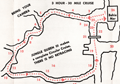 | Details | Jungle Queen Tours | 1960 |
| Route Map Jungle Queen Sightseeing Cruises Fort Lauderdale |
|
Jungle Queen Tours |
|
| 1960 |
| LOC:11 |
| $80.00 | Jungle-Queen-Tours | Route-Map-Jungle-Queen-Sightseeing-Cruises-Fort-Lauderdale | Map of the routes followed by the "World Famous Original" Jungle Queen Sightseeing Cruises ca. 1960. Two cruises were offered on the New River by the operator departing from the Jungle Queen Docks in Bahia Mar, Fort Lauderdale, Florida. One option, the 3-hour Circular Jungle and Everglades Tour, was highlighted by a stop at the Seminole Indian Village (including alligator wrestling). For passengers desiring a later start, at 7:00 p.m. the Jungle Queen II departed with as many as 250 passengers for their Bar-B-Q and Shrimp Dinner cruise followed by a vaudeville review and dancing under the stars.
<br></br>
Three-panel folding brochure closes to a compact 4" x 9".
<br></br>
Tourism has been an important part on the Florida economy for more than 100 years. For many decades operators have offered boat tours as a way of showing off the many attractions of Florida to large numbers of customers. From glass-bottomed boats to mail boats to today's high-speed thrill rides the enthusiasm of tourists for excitement and entertainment on the water has not diminished. |
| 5026 |  | Details | Carr and McFadden, Inc. | 1927 |
| Map and Brochure for Palm Beach Regatta 1927 |
|
Carr and McFadden, Inc. |
|
| 1927 |
| LOC:87 |
| $365.00 | Carr-and-McFadden--Inc- | Map-and-Brochure-for-Palm-Beach-Regatta-1927 | Map (9" x 12") and booklet for the Washington's Birthday Regatta on Lake Worth. Palm Beach Yacht Club, 1927. Florida. Map shows the course of the Regatta races. Very scarce.
<br></br>
33 pages with advertisements, race rules, race history, and members of the Palm Beach Regatta Association.
<br></br>
Map drawn by Carr & McFadden, Inc. Civil Engineers in West Palm Beach Florida. |
| 5029 | 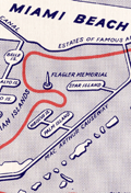 | Details | Anonymous | 1960 |
| Map and Brochure New Uncle Sam Cruise Tour Biscayne Bay Florida |
|
Anonymous |
|
| 1960 |
| LOC:11 |
| $80.00 | Anonymous | Map-and-Brochure-New-Uncle-Sam-Cruise-Tour-Biscayne-Bay-Florida | Brochure for a 2.5 hour touristic cruise of Biscayne Bay, Miami Beach, Florida aboard the glass-enclosed motorboat Uncle Sam. With a map of the path of the cruise (in red) around Biscayne Bay.
<br></br>
The diesel-powered 84-passenger Uncle Sam departed Pier 10 at the Miami Yacht Basin in Bayfront Park and passed the Venetian Islands, the Flagler Memorial, Fisher's Island then crossed the Rickenbacher Causeway. On the return to the yacht basin the Uncle Sam passed the bayfront estates of James Deering (Villa Viscaya), Charles Coryell, Damon Runyon, and more.
<br></br>
Detailed inset map of access roads and parking for the Uncle Sam cruise. Multi-lingual brochure ca. 1960's with key details translated and targeted to appeal to a Spanish-speaking audience: "Mostrando especialmente las mansiones de Cubanos y Portorriquenos en la zona residential…"
<br></br>
Printed on both sides and folds to 4" x 9". |
| 4882 | 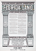 | Details | Sutherland, McConnel and Co. | 1911 |
| Fine Original Broadside for Florida Land Speculators |
|
Sutherland, McConnel and Co. |
|
| 1911 |
| LOC:61 |
| $695.00 | Sutherland--McConnel-and-Co- | Fine-Original-Broadside-for-Florida-Land-Speculators | <br></br>
<div style="text-align: center;font-size:125%;">
"Successful Men Do It Now - <br />Failures Wait Until Tomorrow"
</div>
<BR />
An original antique advertising broadside from the early Florida land boom. A fine, surviving 18" x 24" lithographed copy on thin paper, touting the opportunity that awaited the investor in Florida real estate, including 27,000 acres ("the best tract for farming") near Jacksonville, in Duval County. A fine piece of ephemera that supports and extends any collection of Florida cartography or the history of the Southeast.
<br></br>
The artifact could be considered as the "poster child" of antique Florida ephemera as the two tear-out coupons strongly suggest the broadside was not expected to have a long life and would be discarded after use.
<br></br>
"Virgin Soil", "Pure Water", "1,000,000 Acres to Choose From", "Healthful Climate", "Big Crops".
<br></br>
Offered at prices from $12.50 to $30.00 per acre by the Colonization Department of the partnership of Sutherland, McConnel & Co. of Jacksonville, Florida, Clifford Greve, General Manager. The Auck Brothers of Bucyrus, Ohio were appointed as "Special Agents" for the sale. |
| 1140 | 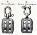 | Details | Boston and Lockport Block Company | 1890 |
| Late 19th Century Trade Catalog of Ships Blocks |
|
Boston and Lockport Block Company |
|
| 1890 |
| LOC:0 |
| $255.00 | Boston-and-Lockport-Block-Company | Late-19th-Century-Trade-Catalog-of-Ships-Blocks | Early trade catalog of ships blocks (pulleys) from a well-known U.S. manufacturer, the Boston and Lockport Block Company ca. 1890.
<br></br>
List of contents from the index includes:
<div class="indenttextblock">
<ul style="list-style-type: circle;">
<li>Blocks for rope straps</li>
<li>Dead eyes</li>
<li>Fiddle blocks for yachts</li>
<li>Jib sheet blocks for yachts</li>
<li>New style yacht blocks with wooden cheeks</li>
<li>Snatch blocks for yachts</li>
<li>Wood dock blocks</li>
<li>Wrought iron blocks</li>
</ul>
</div>
Boston and Lockport used a star as their brand mark. Many of the pages in the catalog are overprinted in yellow with a star and the phrase "Star Brand". 47 pages plus index. |
| 488 |  | Details | Haffenreffer, R.F. | 1940 |
| Yachts by Herreshoff |
|
Haffenreffer, R.F. |
|
| 1940 |
| LOC:0 |
| $150.00 | Haffenreffer--R-F- | Yachts-by-Herreshoff | Promotional book by the Herreshoff Manufacturing Company, Bristol, Rhode Island ca. 1940. Contains eight color reproductions of America's Cup race winners built by Herreshoff, after drawings by R.F. Paterson. These classic vessels designed by Nathanael G. Herreshoff or W. Starling Burgess include the Vigilant, Defender, Columbia (2), Reliance, Resolute, Enterprise and Rainbow. A "Roll of Honor" for these successful America's Cup defenders on page 47 shows that the boats were owned by many of the business leaders of the early 20th century including Cornelius Vanderbilt, Vincent Astor, Alfred Sloan, J.P. Morgan, and Walter Chrysler, among others.
<BR> </BR>
With numerous other black and white photographs of Herreshoff-built boats and manufacturing processes. Contains plans and specifications on glassine paper for eight smaller Herreshoff one-design class offerings from 11 to 31 feet. Table of Contents and Registry of Owners.
<BR> </BR>
Number 8741 presented to J.G. Sheldon. 53 pages as issued. |