| | Thumbnail | | Creator | Date | Title / Author / Date / Location | Price | | | Description |
| 4740 | 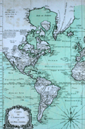 | Details | Bellin, Jacques Nicolas | 1763 |
| Chart Western Hemisphere Petit Altas Maritime |
|
Bellin, Jacques Nicolas |
|
| 1763 |
| LOC:88 |
| $675.00 | Bellin--Jacques-Nicolas | Chart-Western-Hemisphere-Petit-Altas-Maritime | Fine authentic antique chart of the Western Hemisphere by Jacques Nicolas Bellin: "Carte de l'Amerique et des Mers Voisines."
<br></br>
This scarce (12" x 18") copper-plate engraving is from Bellin's "Le Petit Atlas Maritime." Includes North America, South America, west Europe and Africa. Dated within to 1763. |
| 1335 | 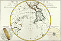 | Details | Bonne, Rigobert | 1787 |
| Western Hemisphere - Antique 45 Degree Southern Oblique Projection |
|
Bonne, Rigobert |
|
| 1787 |
| LOC:0 |
| $0.00 | Bonne--Rigobert | Western-Hemisphere---Antique-45-Degree-Southern-Oblique-Projection | SOLD
<br></br>
Early antique projection covering the Western Hemisphere taken from 45 degrees south latitude. Includes North America, South America, eastern Australia, New Zealand and the South Pacific Islands. The Hawaiian Islands are named the "Iles Sandwich."
<br></br>
An attractive copper-plate engraved map produced by Rigobert Bonne and crisply and finely engraved by Andre to include mountain ranges and numerous place names. Includes two related views on the plate including one colorful view of the "Sphere Oblique."
<br></br>
Rigobert Bonne (1727-1794) was the successor to Jacques Nicolas Bellin as Royal Cartographer to France in the office of the Hydrographer at the Depôt de la Marine. Bonne first came to prominence when he published a number of charts in the Atlas Maritime in 1762, but Bonne is better known for later publications, including the Atlas Encyclopedique, which he collaborated on with Nicholas Desmarest, as well as the maps he produced for Raynal's Atlas de Toutes Les Parties Connues du Globe Terrestre. Published in Paris in 1787. Plate 25. |
| 737 | 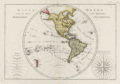 | Details | Bonne, Rigobert | 1787 |
| 18th Century Antique World Map of the Western Hemisphere |
|
Bonne, Rigobert |
|
| 1787 |
| LOC:0 |
| $0.00 | Bonne--Rigobert | 18th-Century-Antique-World-Map-of-the-Western-Hemisphere | SOLD <br></br>
Antique French map of the Western Hemisphere by cartographer Rigobert Bonne from Paris. The copper-plate engraving includes a very decorative compass rose, "Rose de Boussole", at right with all 32 compass points attributed to their named winds in the Mediterranean Sea (e.g., Levante, Syroco, Greco, Ostro, Ponente, Tramontana, etc.) At left is a representation of the globe divided into imaginary climatic zones by the Equator, Tropic of Cancer, Tropic of Capricorn and the Arctic and Antarctic polar circles. Key features include New Zealand, North America, Bering Strait, South America, the Sandwich Islands (Hawaii), numerous islands in the Pacific Ocean, and the Azores Islands. The southernmost point depicted consists of the South Sandwich island group including South Georgia Island.
<br></br>
Rigobert Bonne was the successor to Jacques Nicolas Bellin as Royal Cartographer to France in the office of the Hydrographer at the Depôt de la Marine. This engraved 18th-century plate was published in 1787 in Bonne's ATLAS ENCYCLOPEDIQUE CONTENANT LA GEOGRAPHIA ANCIENNE, ET QUELQUES CARTES SUR LA GEOGRAPHIE DU MOYEN AGE, LA GEOGRAPHIE MODERNE, ET LES CARTES RELATIVES A LA GEOGRAPHIE PHISIQUE…. . Plate 21. |
| 4959 | 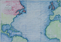 | Details | Becher, Alexander Bridport | 1843 |
| Rare Drift Bottle Chart of the Atlantic Ocean |
|
Becher, Alexander Bridport |
|
| 1843 |
| LOC: |
| $600.00 | Becher--Alexander-Bridport | Rare-Drift-Bottle-Chart-of-the-Atlantic-Ocean | Rare. Little-known, engraved "bottle chart" of the Atlantic Ocean by A.B. Becher (1796-1876), a Commander in England's Royal Navy. After graduation from the Royal Naval College, Becher began a long career that included several assignments related to hydrographic surveying including Canada, the Azores, Africa, and the Cape Verde Islands.
<br></br>
No sales of the "bottle chart" recorded in AMPR. No other similar chart is found for sale online. Only two institutional holdings are confirmed.
<br></br>
In 1843 Becher published this chart in the Nautical Magazine, showing the courses followed by floating bottles where there was information available about the location the bottle was thrown into the sea and where it was found. With his bottle chart Becher included a table with data about the bottle such as the name of the ship, latitude and longitude, the dates the bottle was cast away and found, etc. The data were derived from published records of bottle discoveries that Becher had systematically recorded and published in the Nautical Magazine over the course of 40 years. Those data and associated letters to the editor and comments became known as the "Bottle Papers."
<br></br>
Published by the Proprietors of the Nautical Magazine Feb 1, 1843. Engraved by J and C Walker. Becher was founder and editor of the Nautical Magazine from 1832 - 1871.
<br></br>
Becher also authored "The Storm Compass or Seaman's Hurricane Companion", a booklet for the mariner explaining hurricanes with an emphasis on best practices to predict and avoid hurricanes. |