| | Thumbnail | | Creator | Date | Title / Author / Date / Location | Price | | | Description |
| 755 | 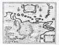 | Details | Blaeu, William Janszoon | 1650 |
| Venezuela cum parte Australi Novae Andalusiae |
|
Blaeu, William Janszoon |
|
| 1650 |
| LOC:200 |
| $695.00 | Blaeu--William-Janszoon | Venezuela-cum-parte-Australi-Novae-Andalusiae | Antique map of Venezuela with the Leeward Antilles and the Windward Islands from the Latin edition of William Blaeu's "Le theatre du monde, ou Nouvel atlas" published in Amsterdam ca. 1650. Islands (not engraved to scale, apparently) include from west to east: Aruba, Curacao, Bonaire, los Rocques, las Aves, la Orchilla, Tortuga, la Blanquilla, Margarita, Grenada, Trinidad, Tobago, , St. Vincent , St. Lucia, Martinique, and Dominica.
<br></br>
Geographic coverage includes the Gulf of Paria, Nuestra Senora de los Remedios, Provincia de los Caracas, Nueva Valencia, Portilla de Carara, Maracapana, Nuestra Senora de Carvalleda, St. Iago de Leon, Nueva Segovia, and the settlement of St. Thomas along the lower Orinoco River.
<br></br>
Cartographic elements include mountains, forests, locations of settlements, bays, and rivers, degrees of latitude and longitude, two compass roses oriented with North at top of plate, and numerous topographical details. Decorative elements include birds, ship, sheep, angels, and monkeys. With two decorative scrollwork cartouches.
<br></br>
This map is one of five maps of South America in Blaeu's atlas which are taken from other Dutch sources. The plates for this map were originally made by the younger Jodocus Hondius sometime before his death in 1629. Hondius' plates were bought by Willem Janszoon Blaeu who replaced Hondius' name with his own. Single vertical fold, as issued. |
| 281 | 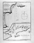 | Details | British Admiralty Hydrographical Office | 1871 |
| Bays of Pampatar and Port Moreno, and Port of Laguna Grande del Obispo |
|
British Admiralty Hydrographical Office |
|
| 1871 |
| LOC:5 |
| $95.00 | British-Admiralty-Hydrographical-Office | Bays-of-Pampatar-and-Port-Moreno--and-Port-of-Laguna-Grande-del-Obispo | Lithographed antique nautical chart shows Port Moreno and the castle and city of Pampatar, Venezuela near the easternmost point on the island of Margarita- Punta Ballena. Also, Laguna Madre del Obispo, a bay on the northern coast of the Golfo de Cariaco in the state of Sucre, Venezuela. Originally published in 1826 with corrections in 1871, these two nautical charts on a single page are copied from earlier copperplate engraved works prepared by the Spanish Direccion Hidrografia ca 1809.<BR> </BR>
<a style="color:#9BAFCB" rel="nofollow" href="/Creator/direccion-hidrografia">See all inventory by the Direccion Hidrografia: </a>
<BR> </BR>Stamp of "Hydrographical Office". Price: sixpence. Notation at bottom: "Sold by J.D. Potter, Agent for the sale of Admiralty Charts, 31 Poultry & 11 King Street, Tower Hill". |
| 282 | 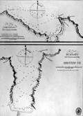 | Details | British Admiralty Hydrographical Office | 1871 |
| The Bay of Corsarios and the Port of Turiamo from Spanish printed plans. |
|
British Admiralty Hydrographical Office |
|
| 1871 |
| LOC:5 |
| $85.00 | British-Admiralty-Hydrographical-Office | The-Bay-of-Corsarios-and-the-Port-of-Turiamo-from-Spanish-printed-plans- | 19th century lithographed antique nautical chart shows two coastal areas in Venezuela: The Bay of Corsarios and The Port of Turiamo. Originally published in 1827 with corrections in 1871, these two charts on a single page are copied from earlier copperplate engraved works prepared by the Spanish Direccion Hidrografia.<BR> </BR>
<a style="color:#9BAFCB" rel="nofollow" href="/Creator/direccion-hidrografia">See all antique nautical charts by the Direccion Hidrografia: </a>
<BR> </BR>Stamp of "Hydrographical Office". Price: sixpence. Notation at bottom: "Sold by J.D. Potter, Agent for the sale of Admiralty Charts, 31 Poultry & 11 King Street, Tower Hill". |