| | Thumbnail | | Creator | Date | Title / Author / Date / Location | Price | | | Description |
| 8077 | 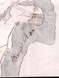 | Details | Unknown Union Source | 1862 |
| The Port Royal Experiment Manuscript Civil War Map Beaufort SC |
|
Unknown Union Source |
|
| 1862 |
| LOC:89 |
| $4,500.00 | Unknown-Union-Source | The-Port-Royal-Experiment-Manuscript-Civil-War-Map-Beaufort-SC | This Civil War–era manuscript map of Beaufort, South Carolina and its surrounding waterways documents the region at the birth of Reconstruction ca. 1862. The map is perhaps the earliest record during what became known as the <b>Port Royal Experiment</b>, when Union occupation, emancipation, and continued military conflict unfolded at the same time. The map shows inland roads, ferries, and navigable rivers, identifies numerous named plantations, and records Union and Confederate picket positions, defensive rifle pits near Beaufort, the battlefield at Port Royal Ferry, and notations of Confederate shelling. It reflects a landscape under Union control but still actively contested.<br><br>The most striking feature of the map is the large number of plantations recorded and the size of the text used to describe plantation ownership vs the military detail. After Union forces captured the Beaufort area in late 1861, most plantation owners fled, leaving more than ten thousand emancipated Gullah people on intact estates without pay, supplies, or legal protection. Beginning in 1862, Northerners arrived to address immediate problems: preventing starvation, organizing paid work, starting schools, and safeguarding newly won freedom for the formerly enslaved. For teachers, missionaries, Treasury agents, and Army officers, a map like this was a working tool. It showed where people lived, where food and cotton were stored, how plantations were connected by roads and waterways, and which routes could be traveled with relative safety. |
| 8030 |  | Details | Crowder, Cyril C. | 1935 |
| Crowder Variable Expansion Propeller Design Drawings |
|
Crowder, Cyril C. |
|
| 1935 |
| LOC:130 |
| $300.00 | Crowder--Cyril-C- | Crowder-Variable-Expansion-Propeller-Design-Drawings | These three manuscript drawings are a striking artifact of early aviation ingenuity, capturing a bold experimental idea that never left the drafting table. Their meticulously rendered telescoping blades, mechanical sections, and handwritten annotations reveal a level of detail and ambition rarely seen in surviving 1930s aeronautical work. As a display piece, it stands at the intersection of engineering art and aviation history: visually compelling, technically imaginative, and representing a line of research that was too impractical for its time or even for today. Framed, it becomes not just a engineering drawing but a cool conversation piece about the inventive spirit of early flight and the folly of some inventors.
<br><br>
Crowder's variable expansion propellor was designed by Cyril C. Crowder of Hollywood, California. No information is found online about the designer nor is any patent found for the design.<br><br> |
| 8024 |  | Details | Paine, Howard E. | 1975 |
| Manuscript conceptual maps for Great Lakes–Midwest region |
|
Paine, Howard E. |
|
| 1975 |
| LOC:130 |
| $500.00 | Paine--Howard-E- | Manuscript-conceptual-maps-for-Great-Lakes–Midwest-region | Unpublished poster-size manuscript conceptual map ca. 1975 by National Geographic Art Director Howard Paine (1) presents a unified Great Lakes–Midwest region extending from Lake Superior to central Kentucky. Rendered in soft colored pencil and wash, the sheet studies regional physiography—rivers, watersheds, and upland structure—without the finished editorial layers of a production map. Paine experiments with state boundaries, drainage patterns, and implied landcover to test how a broad Midwest–Great Lakes treatment might read at atlas scale.
<br><br>
The verso carries a companion terrain study in the same hand, emphasizing elevation, forest cover, and hydrology with Paine’s characteristic, lightly modeled shading. Together the two drawings show the internal design process behind a National Geographic map that was never realized in print, offering a rare look at the developmental artwork that preceded formal cartographic production. They are among the few surviving privately-held examples of Paine’s pre-press regional concept work.<br><br> These conceptual sheets can be securely dated to the late 1960s through the mid-1970s, the period when National Geographic relied on hand-rendered shaded-relief masters and watercolor terrain studies for both its Atlas of the World (6th–8th editions) and the Close-Up U.S.A. series. The green land wash, blue-gray lake treatment, and pencil-modeled hydrology match the Society’s internal cartographic style of roughly 1968–1977, placing Howard Paine’s drafts squarely within that high phase of Nat Geo’s pre-digital map production. |
| 7952 |  | Details | Hill, William | 1786 |
| Rare Headright Plat of Cedar Island Oconee River Georgia |
|
Hill, William |
|
| 1786 |
| LOC:78 |
| $990.00 | Hill--William | Rare-Headright-Plat-of-Cedar-Island-Oconee-River-Georgia | Extremely rare pen and ink manuscript map of Cedar Island, Georgia signed by Thomas McCall (1), Surveyor General of Georgia, just two years before the colony became the fourth state to enter the Union when it ratified the U.S. Constitution on January 2, 1788. The plat survey, conducted March 20, 1786, was related to a warrant issued by Senior Justice Jared Irwin (2), just two years after Washington County was created from land ceded by two treaties with the Creek and Cherokee native Americans in 1783.
<br><br>
The true location of Cedar Island is speculative but, at the top of the document is a drawing of the Cedar Island plat, bisected by a survey line where the two end points were a white oak tree and a cypress tree. The island lies surrounded on all four sides by the Oconee river, and with other properties outside the boundaries, including “Indian Land” at the north. The text reads:
<br><br><div class="indenttextblocksingle">
“Pursuant to a Warrant under the hand of the Honorable Jared Irwin esquire Senior Justice presiding at … court ... in Washington County. Dated March 6,1786. Was Surveyed for Charnill Wallis, who resides in this State a Tract of Land containing Six Hundred Acres in Oconee River called Ceder Island: - Having such form & marks, as are expected in the above plat. Surveyed March 20, 1786 by Jno. Hill D.S. & certified by Saml. Camp pro. b. Surveyor."</div>
<br> |
| 6848 | 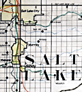 | Details | Utah Railway Chief Engineer | |
| Manuscript engineer's trace |
|
Utah Railway Chief Engineer |
|
|
| LOC:68 |
| $675.00 | Utah-Railway-Chief-Engineer | Manuscript-engineer-s-trace | Singular engineer's presentation trace for the Utah Railway. With this engineer's inked trace map the engineer's office could create numerous blueprint copies for distribution. Produced for the Utah Railway Chief Engineer's office and drawn by Elwood B. Stockman in Feb. 1927. Updated on June 1, 1934. Crisp artwork and lettering. Colors bright.
<br><br>
Shows Salt Lake City with the Salt Lake Base Line at upper left and extends well past Huntington, Utah at bottom right. Shows Park City.
<br><br>
The Utah Railway Company, originally named the Utah Coal Railway, was incorporated on January 24, 1912, and later shortened its name to Utah Railway in May of the same year. The company was founded to transport coal from its mines to Provo, Utah, due to an opening in the competitive landscape caused by dissatisfaction with the existing Denver and Rio Grande Railroad's service and route in the area.
<br><br>
During the 1930s, the Utah Railway faced challenges brought on by the Great Depression, which lowered demand for coal and, consequently, the railroad's business. However, the company managed to maintain its operations and even make some improvements during this difficult period. |
| 6676 |  | Details | Coolidge, P.T. | 1926 |
| Manuscript forest stand map south Allen's Island St George Maine Wyeth |
|
Coolidge, P.T. |
|
| 1926 |
| LOC:86 |
| $350.00 | Coolidge--P-T- | Manuscript-forest-stand-map-south-Allen-s-Island-St-George-Maine-Wyeth | Rare pen and ink manuscript forestry stand map of the south part of Allen's (Allen) Island, Maine. The map was created to represent the vegetation type, stand density and species distribution for South Allen Island in 1924. A century ago spruce predominated at the south end with pasture and scrub growth surrounding an old farm near island center.
<br><br>
Allen Island is a 450-acre private island located in St. George, Knox County, Maine. Situated near the southeastern end of Muscongus Bay, it is the largest island of a small cluster, with Benner Island to the northwest and Burnt Island to the east.
<br><br>
According to historical records, the island was first granted to William Allen, a prominent businessman and politician in Massachusetts, in the mid-18th century. Allen used the island primarily for fishing and hunting, and it remained in his family for several generations. In 1979, the island was purchased by Betsy Wyeth, wife of painter Andrew Wyeth. Prior to their ownership, the island had become a seasonal home for two fishing families living in decaying houses on the fringe of a fast-encroaching spruce forest.
<br><br>
<div id="0" align="center">
<a title=""></a> <img id="3" src="/zoomifyimages/SC_6676/SC_6676_Island.jpg" alt="Allen Island, Maine." width="300"/> <br><small>Allen Island, Maine courtesy Colby College.</small>
</div><br>
Wyeth was drawn to the island's stark natural beauty and solitude, which he found to be a perfect place for inspiration and artistic creation. He spent much of his time on the island, painting the landscape as well as the old decaying houses and structures that dotted the island's coastline. Many of his paintings featuring the island's landscape are considered to be among his most iconic works. |
| 6590 |  | Details | Roma, Cheryl L. | 2004 |
| Maps and notes for an unpublished fantasy novel The Fires of Truth |
|
Roma, Cheryl L. |
|
| 2004 |
| LOC:2001 |
| $450.00 | Roma--Cheryl-L- | Maps-and-notes-for-an-unpublished-fantasy-novel-The-Fires-of-Truth | Like a map we sold a few years ago, <a href="https://www.rarecharts.com/ShowDetail/Creator/Zingg--Andrew/Title/Map-of-the-Future-by-Andrew-Zingg/4846" target="_blank">A New Map of the World</a> by Andrew Zingg , some map creators are driven to lay down their vision of a world that existed only in their imagination. Such are the manuscript maps in the notebooks of author Cheryl L. Roma who labored for three years to write "The Fires of Truth."
<br><br>
While the fate of the unpublished manuscript for Roma's novel "The Fires of Truth" is unknown we are pleased to offer two small bound notebooks that contain manuscript maps for the imaginary world she conceived. Apparently written ca. 2001-2004, the maps are part of two notebooks (Book of the Ancient World and Book of the New Kingdom) that contain research notes on real-world topics such as military formations and terminology, folk healing and folk food, and the structure and organization of royal courts.
<br><br>
The bulk of the notebooks contain historical timelines and numerous details Roma would have used to structure the plot of the book which seems to have had religious overtones. These include a sketch of the Palace of Seven Hills, a table of distances between locations, larger scale maps of Heden's Meadow, Woodburn, Erland's Point, and Amber Hill. |
| 6559 | 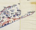 | Details | de Witt, Simeon | 1890 |
| Unusual manuscript trace map of New York state after Simeon de Witt 1802 |
|
de Witt, Simeon |
|
| 1890 |
| LOC:141 |
| $350.00 | de-Witt--Simeon | Unusual-manuscript-trace-map-of-New-York-state-after-Simeon-de-Witt-1802 | One of a kind finely detailed manuscript blue ink trace of sheet 6 from "A Map of State of New York" after Simeon de Witt, 1802. On tracing cloth. This map represents an exceptional effort that likely took days for the anonymous creator to lay down. With a few manuscript notes at bottom right that suggest the trace was created from the copy of de Witt's map held at the New York Public Library (1). Estimated date of creation ca. 1890.
<br><br>
A fine gift for collectors of New York cartography or of rare cartographic oddities.
<br><br>
From an estate with three similar manuscript traced maps of foundational New York State maps by David H. Burr, and <a href="https://www.rarecharts.com/ShowDetail/Creator/Hawkes--W--and-Barber--J-/Title/Manuscript-isodistance-map-of-the-New-York-City-area-after-Hawkes-and-Barber/6560" target="_blank">Hawkes and Barber. </a> Some hydrographic and marshy features in green ink, red ink for roads and highways, brown for political boundaries. Simeon de Witt's original map did not use color to identify these features. At bottom right, in manuscript, a copy of the original title cartouche that was not originally placed on sheet 6, demonstrating the tracer's access to multiple sheets of de Wits map.
<br><br>
(1) Lionel Pincus and Princess Firyal Map Division, The New York Public Library. "Map of the state of New York" The New York Public Library Digital Collections. 1802. https://digitalcollections.nypl.org/items/510d47df-f4d8-a3d9-e040-e00a18064a99 |
| 6560 |  | Details | Hawkes, W. and Barber, J. | 1890 |
| Manuscript isodistance map of the New York City area after Hawkes and Barber |
|
Hawkes, W. and Barber, J. |
|
| 1890 |
| LOC:141 |
| $700.00 | Hawkes--W--and-Barber--J- | Manuscript-isodistance-map-of-the-New-York-City-area-after-Hawkes-and-Barber | Very unusual and one-of-a-kind manuscript traced map ca. 1890 (on tracing cloth) of the area around New York City- after Hawkes and Barber's "The Country twenty five miles round New York" (1777). Text below the map contains a list of important events during the U.S. Revolution in 1776. A key feature of the map is the early use of <b>isodistances</b>, concentric circles at increasing five-mile intervals centered on the city of New York.
<br><br>
This map represents an exceptional effort that likely took days for the anonymous creator to trace. Fine attention to detail and careful execution suggest that the copy was created for research purposes, or possibly for the purpose of producing blueprints from this master trace document. With a few manuscript notes at bottom right that suggest the trace was created from the copy of Hawkes and Barber's map held at the New York Public Library (1).
<br><br>
A fine gift for collectors of New York cartography or of rare cartographic oddities.
<br><br>
From an estate with three similar manuscript trace maps of foundational New York State maps by <a href="https://www.rarecharts.com/ShowDetail/Creator/de-Witt--Simeon/Title/Unusual-manuscript-trace-map-of-New-York-state-after-Simeon-de-Witt-1802/6559"" target="_blank"> Simeon de Witt </a> and David H. Burr. Riverine features in green ink, red ink for highways and roads, brown for political boundaries and for isodistances.
<br><br>
(1) Lionel Pincus and Princess Firyal Map Division, The New York Public Library. "The Country twenty five miles round New York" The New York Public Library Digital Collections. 1777-01-01. https://digitalcollections.nypl.org/items/510d47da-ee36-a3d9-e040-e00a18064a99 |
| 6519 |  | Details | Fuller and Whitney | 1885 |
| Charles River Basin and Harvard Bridge Economic Studies |
|
Fuller and Whitney |
|
| 1885 |
| LOC:300 |
| $1,900.00 | Fuller-and-Whitney | Charles-River-Basin-and-Harvard-Bridge-Economic-Studies | Manuscript surveyors-trace economic option studies for road approaches and the proposed West Chester Park Bridge (now, Harvard Bridge, MIT Bridge, or Massachusetts Avenue Bridge). Eight surveyors' trace documents to support civil engineering and economic options for the placement of the Harvard Bridge, spanning the Charles River between Boston and Cambridge, Massachusetts. General plans for the new bridge were approved in July 1887; the bridge opened in September 1891.
<br><br>
The lot consists of eight MS pen and ink traces (for blueprint production) consisting of two base maps of Boston and Cambridge as well as six MS trace sheets with street and bridge options. The two base maps show the Charles River Basin with the existing West Boston Bridge (Longfellow Bridge) and road network. One map has much greater detail on street names and improved larger lettering.
<br><br>
Six map overlays:<br>
<div class="indenttextblocksingle">
<ul style="list-style-type: circle;">
<li>No 1. Shows the proposed new route as well as text and tabular information for the gain or loss of time over the proposed new route.</li>
<li>No. 2 Shaded area shows lands of the Charles River Embankment Company (proposed Esplanade),
proposed approaches to the Charles River Esplanade and proposed West Chester Park Bridge (aka Harvard Bridge)</li>
<li>No. 3 Approaches for the proposed West Chester Park Bridge (east of the final location)</li>
<li>No. 4 Second option. Bridge located at West Chester (aka Massachusetts Avenue) but terminated slightly more to the east.</li>
<li>No. 5 Third option. Bridge at West Chester, and a proposed wide avenue extending to the end of Commonwealth in Cambridge.</li>
<li>No. 6 Fourth option. No Esplanade </li>
</ul>
</div>
Scale 1650 feet to one inch. |
| 6476 | 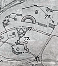 | Details | Rosen, Ludwig | 1890 |
| Engineers manuscript contour drainage plan of the Gärdet in Stockholm Sweden |
|
Rosen, Ludwig |
|
| 1890 |
| LOC:1402 |
| $900.00 | Rosen--Ludwig | Engineers-manuscript-contour-drainage-plan-of-the-Gärdet-in-Stockholm-Sweden | Early and rare engineer's pen and ink manuscript contour drainage plan of Stockholm's Ladugårdsgärdet [1] by States Engineer Ludwig Rosen in 1890. A hand-drawn and hand colored detailed plan on supple surveyors tracing cloth covering land that was at the time largely undeveloped. Today the outer portions of the Gärdet are well developed leaving a central open space that is part of Stockholm’s National City Park.
<br><br>
An important manuscript engineering plan related to urban growth, development, and the environmental preservation of Stockholm, Sweden.
<br><br>
<div id="0" align="center">
<a title="Täckdikningsplan for Ladugårdsgärde vid Stockholm"></a>
<img id="3" src="/ZoomifyImages/SC_6476/SCV_6476_Title.jpg" alt="Täckdikningsplan for Ladugårdsgärde vid Stockholm" width="300"/> <br><small>Title to Rosen's plan of the Ladugårdsgärde (1890)</small>
</div><br>
Plan shows land contour and numerous profile cross-section inset drawings. From a translation of the title "Täckdikningsplan" we can derive that the purpose of the plan was for the development of "cover ditches" or sub-surface drainage systems. North oriented to upper left. Detailed explanatory legend fills the left side of the plan.
<br><br>
[1] Ladugårdsgärdet or Gärdet is a suburb in Stockholm County east and northeast of Östermalm with a current population of roughly 21,500 residents. Until the mid 1800’s, the eastern areas of Stockholm were known as Ladugårdslandet, or “The Barn Land.” Throughout the 1900’s, large areas of Gärdet were developed. |
| 5458 |  | Details | U.S. Coast and Geodetic Survey | 1885 |
| Original antique nautical chart Cape Cod Bay and Provincetown Massachusetts |
|
U.S. Coast and Geodetic Survey |
|
| 1885 |
| LOC:1403 |
| $850.00 | U-S--Coast-and-Geodetic-Survey | Original-antique-nautical-chart-Cape-Cod-Bay-and-Provincetown-Massachusetts | Original rolled, antique U.S. Coast Survey Chart no. 10 of Cape Cod Bay with the Cape Cod Peninsula first published in 1872. Numerous locations from Duxbury to Pochet Island and aids to navigation are highlighted and/or annotated in manuscript pen and ink (e.g. Nauset Beach Beacons, Wood End Light) Includes Provincetown and Provincetown Harbor. Three inset coastal recognition views as seen from offshore.
<br></br>
This is a scarce, separately issued, rolled hydrographic chart of the Massachusetts Coast from 1872, not one of the common folded versions on thin paper from annual report of the U.S. Coast Survey to Congress. This edition issued 1880 by C.P. Patterson. Updates to aids-to-navigation date the print to 1885. The price of this chart when first issued was 40 cents. Electrotype copy #2 [1].
<br></br>
[1] Artifact of the electrotype reprographic technique to create a intaglio copy of the original hand-engraved copper plate, a process the U.S. Coast Survey adopted around 1850. As a soft medium, copper plates could only withstand print runs of perhaps 200 copies before the plates wore down. To enable larger print runs, a mold of the original plate was created in wax or another soft medium. Then, using an electro-chemical process ( electrotyping ), the mold was coated with a metal layer, typically copper. Printers were then able to produce intaglio output from the new electrotype copper copy, while preserving the original hand-engraved plate.
<br></br>
Logo. |
| 5433 | 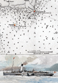 | Details | Anonymous | 1950 |
| Map of Rothesay Sound with watercolor side-wheel steamer. |
|
Anonymous |
|
| 1950 |
| LOC:78 |
| $160.00 | Anonymous | Map-of-Rothesay-Sound-with-watercolor-side-wheel-steamer- | Attractive, offset lithographed chart of Rothesay Sound and the Firth of Clyde, Scotland decorated with a small manuscript watercolor of a side-wheel steamboat. The chart is undated but probably 20th century after an earlier chart. Aids to navigation are highlighted in red and yellow.
<br></br>
The steamboat is unnamed but probably the <strong>Duchess of Fife</strong>, built and launched by Fairfield Shipbuilding and Engineering Company in May 1903. The Duchess of Fife was owned by the Caledonian Steam Packet Company and except for use during WWI and WWII, spent her career serving passenger routes in the Firth of Clyde.
<br></br>
Anonymous but initials "E.S." at bottom right corner. |
| 5393 |  | Details | Anonymous | 1930 |
| Fragments of a manuscript illustrated map of the Caucasus early oil industry |
|
Anonymous |
|
| 1930 |
| LOC:2 |
| $190.00 | Anonymous | Fragments-of-a-manuscript-illustrated-map-of-the-Caucasus-early-oil-industry | Fragments of a larger manuscript pictorial map ca. 1930 of the Soviet Caucasus with early oil industry views. The fragments feature inhabitants of the republics in traditional outfits, some views of the oil derricks and traditional "bazaar" (marketplaces). Illustration of oil derricks show them enclosed in a fabric-covered frame to protect the drilling equipment against the very harsh cold.
<br></br>
The first fragment features Tajik, Turkmen & Uzbek ASSR. The second fragment features Dagestan ASSR, Kabardino-Balkar ASSR, Transcaucasian SFSR and other autonomous republics.
<br></br>
Attributed to a GIZ / IZOGIZ State design bureau worker. Izogiz was the fine arts section of Ogiz publishing. Ink, pencil, gouache on paper. |
| 5370 |  | Details | Stevens, Walter C. | 1892 |
| Manuscript presentation plan for Melrose Common in Melrose Massachusetts |
|
Stevens, Walter C. |
|
| 1892 |
| LOC: |
| $2,500.00 | Stevens--Walter-C- | Manuscript-presentation-plan-for-Melrose-Common-in-Melrose-Massachusetts | Unrecorded hand-colored manuscript presentation plan for the Melrose Common in Melrose, Massachusetts by Walter C. Stevens. 1892. Pen and ink plan of the Common surrounded by Second Street, Sixth Street, Third Street, and Larrabee Street. Scale 20 ft = 1 inch.
<br></br>
According to the History of Melrose, the Melrose Common was developed on land purchased and set aside by D.W. Gooch and Walter Littlefield in 1856 as part of a tract known as "The Home Association Lands." The land lay undeveloped for many years. As late as 1902 the Melrose Common was described:
<div class="indenttextblocksingle">
"... remains in a somewhat primeval state. Year by year, it is being utilized more and more as the place for the City's Fourth of July celebrations, display of fireworks, etc. It is hoped that some day the City will appropriate sufficient money to make of this a beautiful and healthful breathing spot and play ground." </div>
</br>
Two small lakes are shown on the plan. At left a lake contains a circular land area labeled "Maple Island". At right a large, bridged lake features a fountain.
<br></br>
By Walter C. Stevens, Civil Engineer and Surveyor from Melrose, Massachusetts. In 1894 Stevens was listed as "civil engineer for the town of Melrose."
<br></br>
Dated within to 1892. Red crayon surveyor's index collation number "2949". |
| 5365 |  | Details | Anonymous | 1890 |
| Surveyors manuscript trace plat of Little Nahant Island, Massachusetts |
|
Anonymous |
|
| 1890 |
| LOC:13 |
| $750.00 | Anonymous | Surveyors-manuscript-trace-plat-of-Little-Nahant-Island--Massachusetts | Very rare unrecorded, manuscript surveyors' trace plat map of lots on Little Nahant Island, Massachusetts which lies north-east of Boston in Nahant Bay. The pen and ink trace, on supple surveyor's "tracing cloth" would have been used as a master to create blueprint copies.
<br></br>
Carries pencil surveyor's collation number 2013. Includes a fine late 19th century compass rose at bottom right. Estimated date ca. 1885.
<br></br>
Anonymous trace map but stylistically similar to those of W. H. Whitney from the 1890's. |
| 5364 |  | Details | Anonymous | 1909 |
| Pair of manuscript allegorical Maps of the Heart, anatomically correct. |
|
Anonymous |
|
| 1909 |
| LOC:13 |
| $1,100.00 | Anonymous | Pair-of-manuscript-allegorical-Maps-of-the-Heart--anatomically-correct- | Two rare <b>manuscript pen and ink</b> anatomically-correct heart-shaped geographical guides or allegorical maps: "Map of Man's Heart" and "Map of Woman's Heart". Both maps are attributed within circular cartouches reading "Surveyed and Drawn by HUB. Scale 2 miles = 1". 1909." This style of anatomical heart-shaped maps and some of the traits are not found anywhere online.
<br></br>
After similar Victorian-era maps by D.W. Kellogg & Co. of Connecticut ca. 1840. Unlike this manuscript pair of maps, the Kellogg lithographs were based on a stylized and exaggerated bi-lobed conception of the heart- the "Valentine" heart that we know today. Despite the differences in wording of traits, the theme of negative stereotypes for women is the same.
<br></br>
Map of Man's Heart includes large areas devoted to patience, modesty, fidelity (twice), benevolence, humanity, knowledge and love. On the other hand, the Map of Woman's Heart largely features conceit, jealousy, scandal, duplicity, deceit, fickleness and avarice among other traits. The woman's heart is pierced by the "River Tongue" and surrounded on one side by the "kleptomaniac ocean" and on the other side, the "cantankerous ocean".
<br></br>
Seller attributes the provenance to India "it came from a nurses friendship book, she being based in Bangalore India - her name was probably MacDonald." |
| 5358 | 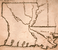 | Details | Anonymous | 1822 |
| Notable manuscript Louisiana map - early 19th |
|
Anonymous |
|
| 1822 |
| LOC:200 |
| $325.00 | Anonymous | Notable-manuscript-Louisiana-map---early-19th | A notable manuscript map of Louisiana by, according to the seller, "a schoolgirl" in Tallmadge, Ohio. Sold from a lot of other maps, one with the attribution: "Tallmadge [Ohio ?] Febr. 7, 1822". The map is notable for the inaccuracies, archaic place names, and a surprising included waterway.
<br></br>
First, the inaccuracy. The land west of the Sabine River, or Texas, was not a British Dominion. In 1822, after Mexico gained independence from Spain a year earlier, the land was Mexican Texas.
Second, in 1817 the State of Mississippi was admitted to the Union. The Mississippi Territory was divided into the State of Mississippi and State of Alabama (1819).
<br></br>
Finally, it is very surprising to see the Iberville River (Bayou Manchac) on this map. Today, Bayou Manchac is a shallow eighteen mile long Bayou but when the French arrived in Louisiana the waterway was the "rivière d'Iberville", an important channel in the area's transportation network. In 1814 Bayou Manchac was closed to the Mississippi and was no longer navigable. |
| 5329 |  | Details | Cruttwell, Eliza Ann | 1824 |
| Fine antique manuscript map of West Indies Caribbean Florida |
|
Cruttwell, Eliza Ann |
|
| 1824 |
| LOC:11 |
| $435.00 | Cruttwell--Eliza-Ann | Fine-antique-manuscript-map-of-West-Indies-Caribbean-Florida | A very fine antique pen and ink manuscript map of the West Indies or Caribbean Sea stretching from Florida to South America. This beautiful one-of-a-kind map reflects extreme precision in execution with careful attention to fine detail and lettering. The map is original and 196 years old; it looks beautiful and fresh.
<br></br>
Shows and labels the provinces of West Florida and East Florida, on a Florida peninsula that has a squared-off form unlike other modern maps of the period and more like Mark Catesby's map of 1743. Includes the islands of Cuba, Santo Domingo, Porto Rico, Trinidad, Barbados, and many of the other usual suspects you would expect to see on a map of the West Indies.
<br></br>
This manuscript antique map of the West Indies, dated within to November 1824, is by signed by E. A. Cruttwell (probably Eliza Ann Cruttwell) (nee Wilson) the wife of Clement Wilson Cruttwell (1780-1816). Eliza Ann Cruttwell (1783-1858) was born in London, England.
<br></br>
Eliza Cruttwell's father-in-law, Rev. Clement Cruttwell (1743-1808) was a well known English publisher of maps and atlases. Clement Cruttwell is best known for his work "The New Universal Gazetteer ; or Geographical Dictionary … with twenty-eight whole sheet maps". London. Pub. G. Kearsley. 1798. That large gazetteer, in 3 volumes, was published in 19 editions. Clement Cruttwell's maps were published by G. G. & J. Robinson from London in 1799 in a separate atlas.
<br></br>
This map was part of a larger lot of manuscript maps by E. A. Cruttwell from the same atlas. |
| 5322 | 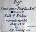 | Details | S. B. Cushing and Company | 1875 |
| Antique manuscript map Seekonk or Pawtucket River Rhode Island |
|
S. B. Cushing and Company |
|
| 1875 |
| LOC:300 |
| $350.00 | S--B--Cushing-and-Company | Antique-manuscript-map-Seekonk-or-Pawtucket-River-Rhode-Island | Scarce historic manuscript pen and ink surveyor's plat map of several tracts of land owned by Phanuel E. Bishop at what is now called "Bishop Point" in Pawtucket, Rhode Island. North is oriented to the bottom. The land, about one mile north of the Phillipsdale Historic District, is bordered to the south and west by the Seekonk (Pawtucket) River, by Bishop Street to the north, and bordered by Charlton Street to the east. The plat, comprised of tracts totaling about 20 acres, shows the line of the high water mark at the boundary of the Pawtucket River.
<br></br>
<img src="https://digitalcollections.uhv.edu/digital/api/singleitem/image/p16791coll2/3342/default.jpg" alt="Phanuel E. Bishop in uniform ca. 1862" width="120" align="left" style="margin: 0px 20px">
Captain Phanuel Euclid Bishop (1844 - 1890) served during the War of the Rebellion in Company H. Ninth Rhode Island Infantry from May 1862 to September 1862. Bishop entered the 1867 class at Brown University where he studied for one year. Bishop then served in Company B, First Battalion Fourteenth Regiment of the Rhode Island Heavy Artillery during 1864 and left the army in October 1865 with the rank of Captain.
<br></br>
The map is a manuscript trace on surveyor's tracing cloth paper by S. B. Cushing and Company Rhode Island. A true copy dated October 9, 1878 signed by Lewis Pearce, Town Clerk.
<br></br>
See online: Chenery, William H. The Fourteenth Regiment Rhode Island Heavy Artillery (Colored,) in the war to preserve the Union 1861 - 1865. Providence. Snow & Farnham. 1898. p. 301. |
| 5317 |  | Details | Campbell, H. J. | 1892 |
| Antique manuscript cadastral map Fernandez Grant Reddick Florida |
|
Campbell, H. J. |
|
| 1892 |
| LOC:1402 |
| $750.00 | Campbell--H--J- | Antique-manuscript-cadastral-map-Fernandez-Grant-Reddick-Florida | Manuscript ink cadastral plat map ca. 1892 of a portion of the Fernandez Grant near Reddick, Florida in Marion County. Made by engineer H. J. Campbell during a period of intensive agricultural growth, facilitated by numerous railroads in the area. The plat is dotted with numerous small unnamed lakes and sinkholes, a product of Florida's' limestone Karst topography. Hand drawn plat on tracing cloth- the map would have been used to generate blueprints on cyanotype paper. Scale 1 inch = 400 feet.
<br></br>
Top of map shows Reddick (established 1882) as a small settlement with a portion of the right of way for the Florida Southern Railroad. The Florida Southern Railway stopped in Reddick as early as 1881. The line went into receivership on March 19, 1890 and when it emerged in 1892 it was acquired by Henry B. Plant as part of his Plant System and reorganized as the Florida Southern Railroad, which stretched from Gainesville through Reddick to Ocala and then to Punta Gorda.
<br></br>
Starting in 1790, Spain offered land grants to encourage settlement to the sparsely populated and vulnerable Florida colony. When the United States assumed control of Florida, it agreed to honor any valid land grants. Portions of the map include lands near Reddick, Florida granted to Stephen Fernandez in 1817 or 1818.
Engineer H.J. Campbell drew a number of town plats in the Marion County area including Stanton and South Lake Weir. The earliest record of Campbell places him in Gainesville, Florida and in 1884 Campbell moved his office to Palatka, Florida. |
| 5284 | ![Manuscript trace of the earliest map of Erving's Grant, 1788 [1910].](../../ZoomifyImages/SC_5284/TN.GIF?v=2) | Details | Avery, F. Deane | 1910 |
| Manuscript trace Erving's Grant Massachusetts Map by Metcalf |
|
Avery, F. Deane |
|
| 1910 |
| LOC:10 |
| $1,100.00 | Avery--F--Deane | Manuscript-trace-Erving-s-Grant-Massachusetts-Map-by-Metcalf | Rare decorative ink manuscript trace map ca. 1910 made by F. Deane Avery (1876 - 1940) of an earlier 1788 [1] map of Erving's Grant, Massachusetts by surveyor Joseph Metcalf in Orange, MA. April 21, 1788 (copied by John ? Pope, Boston, August 11, 1788). The text describing Metcalf's map is in a decorative calligraphic style as might have been used in the late 18th century. The only available true copy of Metcalf's survey of Erving's Grant. [2]
<br></br>
In 1920 Avery, self-described as an "Engineer and Architect", published a short article describing his method of indexing survey artifacts [3]. By 1924 F. Deane Avery was employed as County Engineer in Greenfield, Massachusetts. With Avery's index number "5B-20" at lower right corner.
<br></br>
[1] On February 6, 1788 Massachusetts became the sixth state to ratify the U.S. Constitution and was admitted to the Union.<br>
[2] On the map the land is described as lying in Hampshire County, but today the land lies in Franklin County, Massachusetts.<br>
[3] Avery, F. Deane. "A simple system of indexing notes and plans: Filing by location preferred to other methods- key has numbered areas- loose leaf ledger used". Engineering News-Record. Vol. 85 p. 155. |
| 5270 | 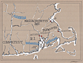 | Details | Griffin, J. Eve | 1997 |
| Manuscript map of tribes Massachusetts, Rhode Island |
|
Griffin, J. Eve |
|
| 1997 |
| LOC:10 |
| $280.00 | Griffin--J--Eve | Manuscript-map-of-tribes-Massachusetts--Rhode-Island | Manuscript map, artwork for the book "Two Paths in the Wilderness" by Ellen Eaton Wilson, published in 1997. The book, about King Philip's War, included the Wampanoag Indians of Rhode Island and the first organized resistance of American Indians to English intrusion on their homelands. This map is the first of two similar MS maps in our inventory by Griffin.
<br></br>
The map, drawn by J. Eve Griffin, is reproduced in the book. Map includes the states of Connecticut, Massachusetts, and Rhode Island with the locations shown for native American Indian tribes: Nipmucks, Narragansett, and Wampanoags. |
| 5271 | 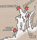 | Details | Griffin, J. Eve | 1997 |
| Manuscript map of Connecticut Massachusetts Rhode Island |
|
Griffin, J. Eve |
|
| 1997 |
| LOC:10 |
| $280.00 | Griffin--J--Eve | Manuscript-map-of-Connecticut-Massachusetts-Rhode-Island | Manuscript map, artwork for the book "Two Paths in the Wilderness" by Ellen Eaton Wilson, published in 1997. The book, about King Philip's War, included the Wampanoag Indians of Rhode Island and the first organized resistance of American Indians to English intrusion on their homelands. This map is the second of two similar MS maps in our inventory by Griffin.
<br></br>
The map, drawn by J. Eve Griffin, is reproduced in the book. Map includes the states of Connecticut, Massachusetts, and Rhode Island with several of the small towns identified including Deerfield, Hadley, Marlboro, Mt. Hope, and Simsbury. |
| 5265 |  | Details | Whitfield Colliery | 1928 |
| Three MS plans mining accidents Whitfield Colliery, Staffordshire, England |
|
Whitfield Colliery |
|
| 1928 |
| LOC:7 |
| $265.00 | Whitfield-Colliery | Three-MS-plans-mining-accidents-Whitfield-Colliery--Staffordshire--England | Lot containing three manuscript plans related to mining accidents at the Chatterley Whitfield colliery (coal mine) in Stoke-on-Trent, Staffordshire, England. The three accidents took place over a period of eight years, attesting to the danger of coal mining.
<div class="indenttextblocksingle">
<ul style="list-style-type: circle;">
<li>Plan shewing scene of accident to Charles Stubbs on Newtons No. 3 north conveyor face institute pit 29th Oct. 1935. [MS plan on paper at a scale of 1/4" = 1 foot]</li>
<li>Plan showing scene of accident to Joseph Howell on No. 5 Bowling Alley Level, Holly Lane dip in the middle pit. 8/1/37 [MS plan of tracing cloth. Scale 1/4" = one foot]</li>
<li>Plan shewing scene of accident to Richard Harper in the No. 3 south ten feet, hard mine dip, middle pit on 27-3-29. [MS plan of tracing cloth. Scale 1/4" = one foot] </li>
</ul>
</div>
The Chatterley Whitfield colliery was the largest mine working the North Staffordshire coalfield and was the first colliery in the UK to produce 1,000,000 tons of saleable coal in a year (1938). In 2019, the colliery was named on the Victorian Society's list of the top ten most endangered buildings in England and Wales. |
| 5222 |  | Details | Paine, Howard E. | 1963 |
| Lot of 3 manuscript design options for Round Earth on Flat Paper NGS |
|
Paine, Howard E. |
|
| 1963 |
| LOC:62 |
| $1,200.00 | Paine--Howard-E- | Lot-of-3-manuscript-design-options-for-Round-Earth-on-Flat-Paper-NGS | Three manuscript sketches, design options by Howard Paine (1) for The Round Earth on Flat Paper used on the inside back cover of the National Geographic Society's first Atlas of the World. <i>(National Geographic Society. 1963.)</i>. From the estate of Howard Paine, Art Director at National Geographic until 1990.
<br><br>
Note: The first image of the four displayed, is from the 1963 NGS Atlas and is for comparison only. Not included.
<br><br>
The booklet "The Round Earth on Flat Paper: Map Projections Used by Cartographers" by Wellman Chamberlin was first published by the National Geographic Society in 1947. In 1963 Chamberlin and Paine collaborated on the design of the inside back and front covers for National Geographic's first <b>"Atlas of the World"</b>: <i>The Earth in Space and The Round Earth on Flat Paper</i>. For <i>The Round Earth on Flat Paper</i> Paine sketched several alternate options. The influence of Paine's early designs are evident in the final design selected for the atlas. |
| 5205 | 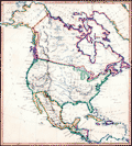 | Details | Morris | 1850 |
| Manuscript Map of North America |
|
Morris |
|
| 1850 |
| LOC:3 |
| $300.00 | Morris | Manuscript-Map-of-North-America | Fascinating antique manuscript map of North America, ca. 1850 by "Morris". Carefully drawn and lettered, this map clearly reflects the work of a dedicated draughtsman with fine penmanship at a very small size. It is difficult to imagine that anyone would be able to work in finer detail than on this small map.
<br></br>
Among the named features, a few help narrow the date when the map was drawn:
<div class="indenttextblocksingle">
<ul style="list-style-type: circle;">
<li>Shows the old West Florida Territory extending westward into Louisiana suggesting a date for the map between 1822 and 1845.</li>
<li>Shows Alaska as "Russian America" a term applied between 1733 and 1867 when Russia sold the Russian colony to the United States of America.</li>
<li>Shows Milledgeville, Georgia, the capital of that state from 1804 to 1868.</li>
<li>The map shows the boundaries of the New Mexico Territory, established in 1850</li>
</ul>
</div> |
| 5198 | 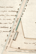 | Details | Anonymous | 1800 |
| Two French Manuscript Cadastral Plans near Dijon, France. |
|
Anonymous |
|
| 1800 |
| LOC:77 |
| $165.00 | Anonymous | Two-French-Manuscript-Cadastral-Plans-near-Dijon--France- | Two manuscript cadastral plans of lands in France belonging to Mr. Jacob, one with grape vines, ca. 1790. Today there are at least two wine producers operating in France with the name Jacob. Both wineries lie about 30 km southwest of Dijon, France near the main road : Domaine Jacob and Domaine Lucien Jacob.
<br></br>
<div class="indenttextblocksingle">
1) MS plan of an L-shaped lot belonging to Mr. Jacob and containing 49 ares and 49 centiares. Site plan was located at the intersection of the "Grande route de Dijon a Paris" and the "Chemin de Memont a Dijon." North oriented to the right with a fine arrow direction indicator. 8" x 6". </br>
2) MS plan of two lots belonging to Mr. Jacob. One lot planted with grapevines. 7" x 5".
</div>
</br>
A French "are" was a metric measurement equal to 100 square meters; a "centiare" was equal to one square meter. Usage of ares and centiares dates the map after the French Revolution, when France adopted the Metric System of measurement. |
| 5199 |  | Details | Anonymous | 1880 |
| Manuscript plan of Chalon-sur-Saône, France |
|
Anonymous |
|
| 1880 |
| LOC:77 |
| $175.00 | Anonymous | Manuscript-plan-of-Chalon-sur-Saône--France | Fine manuscript pen and ink plan ca. 1880 titled: "Plan de deux enceintes primitives de Chalon sur Saone." Show the ancient city with the two ancient walls or "enceintes" at the village of Chalon-sur-Saône, France. Notes the location of many interesting sites including the "gibet" (gibbet) or post used as a gallows or place of execution.
<br></br>
With a unperforated red stamp bearing three circles ( the coat of arms of Chalon sur Saone) above the French medal Legion d'Honneur surmounted by a crown. Napoleon I awarded the Legion d'Honneur to the town of Chalon sur Saone in 1815 in recompense for their support during his Austrian campaign.
<br></br>
Top is oriented to the northeast. Shows the Saone river with bridges at right. |
| 5183 | 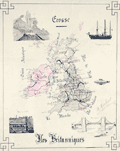 | Details | Herbinet, B. | 1895 |
| Manuscript map Iles Britanniques with submarine |
|
Herbinet, B. |
|
| 1895 |
| LOC:200 |
| $250.00 | Herbinet--B- | Manuscript-map-Iles-Britanniques-with-submarine | Interesting manuscript French map "Iles Britanniques" with vignettes illustrating the prowess of those isles at a time when Britain ruled the waves. Shows major roads or railways.
<br></br>
Inset vignettes include:
<div class="indenttextblocksingle">
<ul style="list-style-type: circle;">
<li>A suspension bridge</li>
<li>A coal mine</li>
<li><b>An early submarine: "la Gombe. Bateau sous marine"</b></li>
<li>A transitional three-masted warship with supplemental steam power </li>
<li>A geyser</li>
</ul>
</div>
Beautifully signed in manuscript "B. Herbinet Avril 1895" |
| 5172 |  | Details | Campbell | 1983 |
| Original manuscript art for Reagan era Central America Game cartoon |
|
Campbell |
|
| 1983 |
| LOC:200 |
| $1,750.00 | Campbell | Original-manuscript-art-for-Reagan-era-Central-America-Game-cartoon | Rare original manuscript art by Campbell for Reagan era "Central America Game" cartoon, 1983. This one-of-a-kind satirical cartoon references decades of United States involvement in attempts to overthrow Central and South American governments (Cuba, Panama, Chile, Venezuela ), some successful.
<br></br>
Set surrounded by sea, spanning a globe, political leaders conduct a dialog above a gameboard emulating the landmass of Central America with Pinochet and Castro as board pieces. Ronald Reagan asks Henry Kissinger about the rules for meddling in the Americas. Dialog:
<div class="indenttextblocksingle">
<b>Ronald Reagan: </b>"How do you win this 'Central America' game Henry?"<br>
<b>Henry Kissinger: </b>"I'm not sure anyone ever has, Mr. President."
</div>
</br>
Pen and ink manuscript sketch with a few edits in white-out. Signed "Campbell Aug 11, 1983."
<br></br> |
| 5173 | 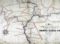 | Details | Wierman Jr., T. T. | 1876 |
| Map Showing the Canals Belonging to the Pennsylvania Canal Company. |
|
Wierman Jr., T. T. |
|
| 1876 |
| LOC:200 |
| $1,150.00 | Wierman-Jr---T--T- | Map-Showing-the-Canals-Belonging-to-the-Pennsylvania-Canal-Company- | Manuscript thematic surveyor's map from 1876 detailing the visible hydrographic features of east central Pennsylvania with numerous rivers, creeks and canals. The map's theme is the canals belonging to the Pennsylvania Canal Company.
<br></br>
The map was probably used to generate blueprint copies and dates to the beginning of the decline of the Pennsylvania Canal System. In 1867, the Pennsylvania Railroad formed the Pennsylvania Canal Company using their canals to haul freight. By 1900 most Pennsylvania canal were unused, a victim of the significant financial advantage provided by the railroads
<br></br>
With a finely drawn compass rose with a fleur de lis skewered by a gaily festooned pointer. Also contains much detail about railroads, bridges and towns, a reflection of the company's ownership by a railroad company.
<br></br>
Portions of the waterways are labeled as :
<div class="indenttextblocksingle">
West Branch Division
Juniata Division Penna Canal
Wyoming Division Pennsylvania Canal
Pennsylvania Canal
Union Canal
</div>
The map contains all or part of the following Pennsylvania counties: Blair, Center, Clynton, Huntingdon, Mifflin, Snyder, Juniata, Perry, Cumberland, York, Lancaster, Dauphin, Northumberland, Montou, Columbia, Luzerne, Lycom, Centre.
<br></br>
Drawn by T. T. Wierman Jr. Assistant Engineer. |
| 5126 | 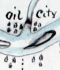 | Details | Pomeroy, S.T. | 1865 |
| Manuscript early map of Pennsylvania Oil Fields |
|
Pomeroy, S.T. |
|
| 1865 |
| LOC:200 |
| $3,750.00 | Pomeroy--S-T- | Manuscript-early-map-of-Pennsylvania-Oil-Fields | A hand-drawn antique map, a historical cartographic artifact related to the early days of oil production along the Allegheny River in the U.S.A. An unrecorded foundational map for U.S. oil production created by S.T. Pomeroy six years after oil was first commercially produced in Pennsylvania. The main focus of the oil-field map seems to be a series of leases (in yellow) along Pine Run Creek.
<br></br>
This one-of-a-kind pen and ink manuscript map of oil fields in Pennsylvania was created during a time of great speculative excitement just six years after Edwin L. Drake struck "rock oil" at Titusville, Pennsylvania in Oil Creek Valley in 1859. Drawn by hand by Pomeroy in 1865, near the end of the Civil War, coverage includes lands, leases, wells, and waterways beginning about 8 miles south of Titusville.
<br></br>
Shows the Allegheny River and Clarion Rivers and the significant tributaries of Oil Creek, Pit Hole Creek, East Sandy Creek, Pine Hill Run, Big Sandy, and Hemlock Creek. With newly developed Oil City, Franklin, and President, Pennsylvania as well as a clear route for the turnpike linking Oil City, Sandy, and Franklin. One well near the confluence of the Allegheny River and East Sandy Creek is shown as producing 250 barrels daily, quite a prolific output in those days.
<br></br>
The Pomeroy name was somewhat common in Pennsylvania during that time period, but details on the map of islands in the Allegheny River and the wells along the rivers and creek suggest a nautical connection. Pomeroy's Oil Creek Boat Express operated a river-barge, the "Pomeroy Express" along Oil Creek.
<br></br>
(Sketches in Crude Oil: Some Accidents and Incidents of the Petroleum …) https://books.google.com/books |
| 5085 |  | Details | Anonymous | 1970 |
| Manuscript copy of the map City of Bath after Joseph Gilmore |
|
Anonymous |
|
| 1970 |
| LOC:200 |
| $450.00 | Anonymous | Manuscript-copy-of-the-map-City-of-Bath-after-Joseph-Gilmore | Manuscript pen and ink (hand drawn) map of the City of Bath, England after an earlier map by Joseph Gilmore in 1731. On heavy paper. Likely mid-20th century. Differs from Gilmore's original map of Bath in that fewer buildings are shown on the border of the map.
<br></br>
Gilmore's original elaborate map of the city of Bath shows Bath still largely contained within its medieval walls. The map indicates the growing popularity of Bath as a destination for visitors in the early 18th century. Around the border of Gilmore's map are views of 36 lodging houses or other public buildings. The map was reissued 6 times between 1694 and 1731. |
| 5065 | 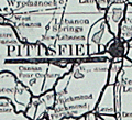 | Details | Plumb, Arthur W. | 1908 |
| Scarce Maplewood Hotel Pittsfield, Massachusetts Advertisement |
|
Plumb, Arthur W. |
|
| 1908 |
| LOC:400 |
| $325.00 | Plumb--Arthur-W- | Scarce-Maplewood-Hotel-Pittsfield--Massachusetts-Advertisement | Rare point-of-sale advertising placard for the Maplewood Hotel in the Berkshire Mountains, ca. 1908.
<br></br>
Edges of the placard contain manuscript advertising copy:
<div class="indenttextblocksingle">
"One of the automobile road maps will be mailed free to anyone sending their names to A.W. Plumb, Pittsfield, Mass.
<br></br>
The most picturesque auto. trip in America is up through the Berkshire Hills via Lenox, Pittsfield and Manchester, Vt."
</div>
</br>
The Maplewood Hotel opened in 1887, converted from the Pittsfield Young Ladies Institute. The girl's school had operated on the site since 1841. Later, the school was known as the Maplewood Institute which has historical connections to the world of intercollegiate athletics.
<div class="indenttextblocksingle">
"… the school hosted the country’s <b>first intercollegiate baseball game</b>, with rival schools Amherst College and Williams College playing here on July 1, 1859. The game drew large numbers of Maplewood girls, who watched Amherst win 73-32 in 26 innings, in a game that bore little resemblance to today’s game." (Source: http://lostnewengland.com/2017/02/maplewood-pittsfield-mass-1/)
</div> |
| 5053 |  | Details | Anonymous | 1918 |
| Two manuscript maps of St. Augustine, Florida and of the area. |
|
Anonymous |
|
| 1918 |
| LOC:11 |
| $400.00 | Anonymous | Two-manuscript-maps-of-St--Augustine--Florida-and-of-the-area- | Two manuscript maps on a single sheet inserted into a tourism brochure of St. Augustine, Florida after printing. Unusual. Maps show St. Augustine at street-level detail and on verso a smaller-scale map of the area surrounding St. Augustine. Type-written text on one map sheet indicates re-use of a telephone service remittance document for creation of the map. The small scale map of the area around St. Augustine appears only to consider railway lines (F.E.C., A.C.C.) of importance as railways are highlighted in color and stops along each route are identified.
<br></br>
Booklet (folds to 4" x 9") presented with the compliments of the St. Augustine Hotel Association. Fine cover graphics of period clothing. Booklet art work, engraving and printing by the Record Company, St. Augustine. Dated between 1916 and 1919 based on information provided about the Flagler Hospital, under construction at printing, after a fire in 1916 destroyed much of the original structure. |
| 5007 | 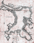 | Details | Pujals, Jose | 1891 |
| Antique manuscript map plan of the Bay of Havana, Cuba with Regla |
|
Pujals, Jose |
|
| 1891 |
| LOC:200 |
| $700.00 | Pujals--Jose | Antique-manuscript-map-plan-of-the-Bay-of-Havana--Cuba-with-Regla | MS plan and hydrographic chart of the bay of Havana, Cuba. Very early surveyor's master document on tracing cloth of Havana, Cuba with blue color from the verso, as was the practice of the era for creating shading on blueprints. This manuscript map was intended for use in generating multiple cyanotype (blueprint) copies.
<br></br>
Names several important locations including Regla, Cabana, Ensenada de Mari Melena, and Casa Blanca. The plan includes isobaths showing depth of water in Havana Bay.
<br></br>
MS notation in Spanish reads: "Corresponde a la Real Orden de consesion des dichas obras fecha de 17 de ?? Habana de 13 Febrero de 1891 J. Pujals"
<br></br>
Creator is presumed to be Jose Pujals, an engineer with the Port of Havana Cuba. In 1899 Jose Pujals was the directing engineer in charge of works at the Port of Havana. On February 1, Captain A.H. Weber of the Second United States Volunteer Engineers was appointed as directing engineer and Pujals was moved to a position as Weber's assistant.
<br></br>
Scale 1:2500. |
| 4993 | 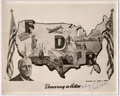 | Details | Perone, Frank T. | 1941 |
| WWII FDR Patriotic Pictorial Map Photo with Perrone MS signature |
|
Perone, Frank T. |
|
| 1941 |
| LOC:0 |
| $125.00 | Perone--Frank-T- | WWII-FDR-Patriotic-Pictorial-Map-Photo-with-Perrone-MS-signature | One-of-a-kind WWII FDR patriotic pictorial map of the United States with creator's manuscript dedication and MS signature of Frank T. Perone. A photographic copy from the original. No other copy of this map was found.
<br></br>
Similar to, but different from, a 10" x 14" colored version of Perone's map published by Allied Printing of Atlantic City titled "Remember Pearl Harbor" (of which no known examples were found in institutional collections). Probably an earlier concept design by Perone.
<br></br>
Includes several scenes and features found in the (presumed later) colored version including the association of freedom, defense, and recovery with the initials FDR.
<br></br>
Differs from the colored version as follows:
<div class="indenttextblocksingle">
<ul style="list-style-type: circle;">
<li>Our map is not set upon a flag background, rather the flags appear at the image sides.</li>
<li>Our map shows FDR as a much older man, not the youthful FDR found in the colored version.</li>
<li>Our map shows engines and a top gunners-turret on the airplane.</li>
<li>Perhaps most interesting is our map includes an image of a four-finned rocket in flight that is missing from the colored version.</li>
</ul>
</div>
Copyright May 1, 1941; K 4907, 47908. |
| 4967 |  | Details | Barker, Charles R. | 1915 |
| Three antique manuscript maps of Ardmore Pennsylvania |
|
Barker, Charles R. |
|
| 1915 |
| LOC:200 |
| $600.00 | Barker--Charles-R- | Three-antique-manuscript-maps-of-Ardmore-Pennsylvania | Lot of three original hand-drawn (manuscript) maps of Ardmore, Pennsylvania. Ardmore, a close suburb on the west side of Philadelphia, lies within Montgomery County and Delaware County.
<br></br>
The largest map, at 8" x 16", is a large-scale MS plat map, a copy of an 1822 tract map for land owned by Simon Litzenberg. The copy was made by Charles R. Barker on August 1, 1915.
<br></br>
The other two manuscript maps each roughly 8" x 12" are smaller scale maps of Ardmore Pennsylvania with detail. One map with hand color and showing the campus for Haverford College and the Merion Cricket Grounds. Not signed; presumed by Barker. |
| 4964 | 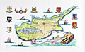 | Details | Sabry, John | 1980 |
| Manuscript map of Cyprus by Cypriot artist John Sabry |
|
Sabry, John |
|
| 1980 |
| LOC:200 |
| $1,800.00 | Sabry--John | Manuscript-map-of-Cyprus-by-Cypriot-artist-John-Sabry | Manuscript (hand-drawn) illustration of Cyprus by Cypriot artist John Sabry (1914-2006). ( Τζων Σάμπρι ). Date not stated but assumed 1980's. Fine condition.
<br></br>
Sabry is the author of pictorial maps of Cyprus in the "Romantic Cyprus" guide book (1947): Famagusta & Varosha, and Nicosia. John Sabry was born and raised in Kyrenia, Cyprus; a painter from an early age, he also worked as a professional photographer and managed the Kodak shop in Nicosia during the 1950’s.
In 1965 three of Sabry's paintings were selected for the Royal Academy Summer show in London. |
| 4940 |  | Details | Anonymous | 1809 |
| Manuscript chart of the island of Diego Garcia |
|
Anonymous |
|
| 1809 |
| LOC:200 |
| $975.00 | Anonymous | Manuscript-chart-of-the-island-of-Diego-Garcia | French manuscript chart of the island of Diego Garcia. Diego Garcia, a coral atoll, is the largest and southernmost member of the Chagos Archipelago, in the central Indian Ocean.
<br/><br/>
Dated on or near May 2, 1809 when the French Governor of Mauritius Decaen granted rights over the island to Cayeux, the Didier brothers, and Lapotaire. Lapotaire was reported to have over 100 slaves working his copra plantation in 1809. The map clearly shows those three land holdings, with Didier at the southern end of the island. (Cawley, Charles. Colonies in Conflict: The History of the British Overseas Territories. Cambridge Scholars Publishing. 2015.)
<br/></br/>
"Portuguese explorers discovered Diego Garcia in the early 1500s. The islands remained uninhabited until the 18th century when the French established coconut and copra plantations with the help of slave labor. Diego Garcia became a possession of the United Kingdom after the Napoleonic wars, and from 1814 to 1965, it was a dependency of Mauritius."
(Source: https://www.cs.mcgill.ca) |
| 4920 |  | Details | Ruger, General Thomas H. | 1895 |
| Manuscript plans of Harbor Defenses, U.S. Department of the East |
|
Ruger, General Thomas H. |
|
| 1895 |
| LOC:0 |
| $6,000.00 | Ruger--General-Thomas-H- | Manuscript-plans-of-Harbor-Defenses--U-S--Department-of-the-East | One lot with 19 pen and ink manuscript plans (7" x 11.5") of U.S. harbor defenses with artillery at various ports from Portland, Maine to the Mississippi River including Pensacola, Key West, and Charleston. Data on the artillery includes the location and type of armament including the 16″ BLR (breech loading rifle), 12″, 10″, 8″ BLR, Dynamite Guns, 12″ Mortars, and quick loading guns. From a collection of the papers of General Thomas Ruger, late in his career.
<br></br>
In 1886 the Board of Fortifications, led by Secretary of War William C. Endicott, issued a report (Endicott Report) on the need for changes to the armament along the coastal forts of America. The use of mortared brick walls and smoothbore cannon were outdated.
<br></br>
Endicott era forts were constructed with concrete walls that concealed large, breech-loading rifled artillery guns mounted on "disappearing carriages". These carriages allowed the new, rifled cannons to be raised above the walls, aimed, and fired, and then quickly retrieved back into position. (Source: https://www.nps.gov/gate/learn/historyculture/endicotteradefenses.htm)
<br></br>
Along with the 19 charts are six spreadsheets containing tabular compilations of the count and size of artillery at each location. Includes a personal letter to Ruger from his papers.
<br></br>
Thomas H. Ruger (1833-1907) was born in New York and grew up in Wisconsin. Ruger graduated the U.S. Military Academy in 1854. He was commissioned in the Wisconsin Volunteers during the Civil War; wounded at the Battle of Antietam and participated in eastern battles such as Chancellorsville and Gettysburg, before being transferred to Sherman’s Army and the famous march to the sea. Following the Civil War, Ruger was military governor of Georgia, Superintendent at West Point, and commanding general of the Department of the East from 1895-1897.
<br></br>
See Endicott Report online : https://babel.hathitrust.org/cgi/pt?id=njp.32101059089340&view=1up&seq=7 |
| 4909 |  | Details | Anonymous | 1859 |
| Antique manuscript plat Queens, New York deBevoise |
|
Anonymous |
|
| 1859 |
| LOC:200 |
| $500.00 | Anonymous | Antique-manuscript-plat-Queens--New-York-deBevoise | One of a kind manuscript map ca. 1859 of a plat of land in the city of Newtown, borough of Queens, New York. Newtown was founded as Middenburgh by the Dutch in 1652. In the 17th century Dutch colony of New Netherland, Newtown was a suburb of New Amsterdam, and was renamed "Elmhurst" in 1897.
<br></br>
Shows a tract of woodlands, owned by farmer Abraham de Bevoise. Contains surveyors' field notes including the metes and bounds [1] of the plat relating it to land owned by Theodorus Kolyer (d. 1854). A fine, piece with a simple, pastoral view of the woodlands owned by de Bevoise, totaling two acres and 4 perches. A perch is a unit of area equal to 1/160 of an acre.
<br /> <br />
Abraham de Bevoise (1819 - 1887) was a farmer originally of French Huguenot ancestors.
<br /> <br />
<div class="indenttextblocksingle">
[1] The term "metes" refers to a boundary defined by the measurement of each straight run, specified by a distance between the terminal points, and an orientation or direction. A direction may be a simple compass bearing, or a precise orientation determined by accurate survey methods. The term "bounds" refers to a more general boundary description, such as along a certain watercourse, a stone wall, an adjoining public road way, or an existing building. (Online Source: https://definitions.uslegal.com/m/metes-and-bounds/)
</div> |
| 4887 | 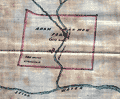 | Details | Stewart, John Frew | 1900 |
| Four manuscript survey plats of Kentucky land. |
|
Stewart, John Frew |
|
| 1900 |
| LOC:13 |
| $250.00 | Stewart--John-Frew | Four-manuscript-survey-plats-of-Kentucky-land- | One lot of four manuscript plats of Kentucky real estate on surveyors' tracing cloth from ca. 1900. Attributed to John Frew Stewart of Paintsville, Kentucky. Includes a MS list of other maps sent out by Stewart in 1900.
<br></br>
John Frew Stewart (1833-1906) studied law at the office of Moore and Gallup at Louisa, and obtained a license to practice law in 1860. He was elected county attorney for Lawrence County, Kentucky in August, 1862. The next month Frew joined the Union army as a private and swiftly obtained the rank of Second Lieutenant in the Thirty-ninth Kentucky volunteers and again as major of his regiments in November, 1864.
Stewart held several government positions including Deputy Collector for the Internal Revenue, county school commissioner, and county judge.
<br></br>
Proceeding clockwise from upper left the maps include:
<div class="indenttextblocksingle">
<ul style="list-style-type: circle;">
<li>Adam Harmon Farm, 600 acres situated on a branch of the Stillwater River in Wolfe County, 5 miles from Campton. Size: 9" X 8"</li>
<li>Plat of 131 3/4 acres tract on a branch of Gladys Creek. Rowan County, KY.</li>
<li>Signed list of maps and plots</li>
<li>Plat of land of 139 acres on the Tire Branch of White Oak Creek in Mugoffin, Co. Kentucky</li>
<li>Plat of 250 acres on the left fork of Craney Creek, Morgan County, KY.</li> |
| 4866 |  | Details | Rose, Edwin | 1872 |
| Manuscript cadastral map of Snow Shipyard Portland, Maine. |
|
Rose, Edwin |
|
| 1872 |
| LOC:0 |
| $1,675.00 | Rose--Edwin | Manuscript-cadastral-map-of-Snow-Shipyard-Portland--Maine- | Large manuscript map by Edwin Rose of the Snow Farwell and Company property in Rockland, Maine dated within to July 5th, 1872. A rare and informative map of the waterfront at south Rockland, Maine with a detailed record of shoreline and structures as they existed 150 years ago.
<br></br>
A few of the key features Rose noted include Mechanic Street, two marine railways and a marine railway wharf, apparently part of Snow Farwell & Co. The two octagonal building above the railways are almost certainly sheds for horse-powered winches. At bottom left a wharf surrounds
<br></br>
Snow Shipbuilding was founded in 1862 by Captain Israel Snow. It was located at the end of Mechanic Street, adjacent to the Cobb, Butler yard. The Snow family sold it to General Seafoods after WWII. The western half is now the Sail, Power and Steam Museum, while the eastern half is still active as Rockland Marine.
<br></br>
Location fronts on Owl's Head Bay; West Penobscot Bay. Surveyed by Edwin Rose Esq. Drawn by L.L. Buckland. Scale 50 feet to 1 inch. |
| 4856 |  | Details | Danforth, Frederic | 1890 |
| Manuscript Belfast, Maine Water Company Plan for Robert Elwell |
|
Danforth, Frederic |
|
| 1890 |
| LOC:0 |
| $1,150.00 | Danforth--Frederic | Manuscript-Belfast--Maine-Water-Company-Plan-for-Robert-Elwell | Original four-foot wide manuscript survey of Water Reservoir Number 1 at Belfast, Maine. "Plan of Land of the Belfast Water Company Made for Robert Elwell." By Frederic Danforth C.S. Dated within at October, 1890. Laid to linen.
<br></br>
The Belfast Water Company was founded in 1887 after two major fires (1865, 1871) demonstrated the existing water supply was insufficient. Construction began on the reservoir with a 175 foot long dam near the mouth of Little River. Scale 1 inch = 80 feet.
<br></br>
The water district discontinued using the Little River reservoir in 1980. Today the brick pump house on the north side of the dam serves as the offices of the Belfast Water District.
<br></br>
<div class="indenttextblocksingle">
Frederick Danforth, son of Judge Charles Danforth, was born in 1848. He graduated from Dartmouth College, specializing in civil engineering. After graduation Danforth settled upon the career of railroad engineering. In 1876, after an engagement with the European and North American railway Danforth established an office in Gardiner, and in 1891 he was elected a member of the American Society of Civil Engineers. (Online: http://files.usgwarchives.net/me/kennebec/gardiner/history/
kingsbury/gardiner/kengard.txt.)
</div> |
| 4804 |  | Details | U.S. Coast and Geodetic Survey | 1894 |
| Antique MS engineering drawing of screw-pile day-mark beacon |
|
U.S. Coast and Geodetic Survey |
|
| 1894 |
| LOC:55 |
| $450.00 | U-S--Coast-and-Geodetic-Survey | Antique-MS-engineering-drawing-of-screw-pile-day-mark-beacon | Fine late 19th-century manuscript engineering drawings of a screw-pile day-beacon designed for the Tobago Middle Ground shoal in the Rappahannock River, Virginia. Probably a product of the U.S. Coast and Geodetic Survey. Dated within to 1894. Baltimore, Maryland.
<br></br>
Manuscript pencil notations: "Not used" and "Historical".
<br></br>
In a 1896 letter to Congress transmitting estimates of appropriations from the Secretary of the Treasury is a line item for $3,000 for "Establishing a day beacon on or near the Tobago Middle Ground, Rappahannock River, Virginia." A note below the item states: "The middle ground has but four feet of water on it. A prominent mark would be a valuable aid in the navigation of that part of the river." Apparently this request derived from the Lighthouse Board who proposed to build a screw-pile beacon at Tobago as early as 1893.
<br></br>
Our drawing, from 1894, is annotated with the words "not used". That may very well be because a less expensive solution was adopted. According to the U.S. Coast and Geodetic Survey Notice to Mariners in 1903 "a black spar buoy, without number, was placed in 15 feet of water on the edge of the shoal opposite the upper end of Tobago Middle Ground." |
| 4738 | 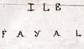 | Details | Favereau, Charles-Eugene | 1875 |
| Manuscript Notebook of Vice Admiral Charles Favereau with Charts |
|
Favereau, Charles-Eugene |
|
| 1875 |
| LOC:2001 |
| $1,500.00 | Favereau--Charles-Eugene | Manuscript-Notebook-of-Vice-Admiral-Charles-Favereau-with-Charts | <img src="\PageImages\Charles_Eugene_Favereau_Vice_Amiral.jpg" alt="French Vice-Admiral Charles Eugene Favereau" width="150" Align="left" style="margin:1em">Rare and desirable notebook including much tight French script and eight MS charts and port plans from the early training cruises of Vice-Admiral Charles Eugene Favereau (1856-1936), then an aspirant (Midshipman) in the French Navy.
<br></br>
Favereau entered Naval School in October, 1872 and after three years was an aspirant in October, 1875. Favereau first served on the training ship ALEXANDER and then on the GAULOISE in the Mediterranean and in 1877 on the MAGICIENNE in the Pacific. (Source: http://ecole.nav.traditions.free.fr/officiers_favereau_charles.htm)
<br></br>
During a long career in the French Navy Favereau served as Lieutenant Commander, Commander, and Captain aboard the cruiser NAIADE, the battleships FORMIDABLE, REPUBLIC, ST.LOUIS and BAYARD. On June 30, 1910 Favereau was promoted to contre-Admiral, and on January 28, 1914 to Vice Admiral . He left the Navy in 1918.
<br></br>
Favereau's eight ink manuscript harbor plans and charts include ports on the Mediterranean north coast of Africa, the Azores, Spain, and the islands of Madeira.
<div class="indenttextblock">
a) Port d'Alger (Algiers) </BR>
b) Plan du Mouillage de Mers al Kebir</BR>
c) Partie est de Madere (East portion of the Madeira archipelago)</BR>
d) Plan de Funchal et de la Baie</BR>
e) Western Azores (Sao Jorge, Faial, and Pico)</BR>
f) Plan of Fayal (Faial) and Baie de Horta</BR>
g) Faial-Pico channel</BR>
h) Vigo estuary and Cies Islands</BR>
</div>
</BR>
Text of about 80 pages in French. Small drawings of devices and machinery related to weapons and artillery. With small notations in red at several points believed to be grades or acknowledgement of completion by an instructor. |
| 3629 | 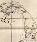 | Details | Nickerson, K.F. | 1955 |
| Manuscript chart of Cape Cod, Massachusetts Bay, Provincetown |
|
Nickerson, K.F. |
|
| 1955 |
| LOC:200 |
| $450.00 | Nickerson--K-F- | Manuscript-chart-of-Cape-Cod--Massachusetts-Bay--Provincetown | An interesting manuscript chart of Cape Cod and Cape Cod Bay in black and red ink. Not only does the chart have a different look than a printed chart but the item raises questions as to why so much care was placed on its creation. Signed by K.F. Nickerson and dated to February 1955.
<br></br>
Detailed mid 20th-century manuscript chart of Cape Cod, Massachusetts Bay and Cape Cod Bay. The MS chart is drawn on the verso of an earlier chart from 1935. Nickerson apparently cannibalized an old chart simply to create his chart on the back. We don't know why Nickerson spent so much time on the chart but it is evident he spent hours meticulously copying from an unknown source. Perhaps the map was constructed for sale as a tourist keepsake. More likely it had some utility to Nickerson in his occupation, because the chart detail is at a granular level that could be used for navigation.
<br></br>
Contains info on radio beacons, depth soundings, maritime hazards, aids to navigation and much more. Scale 1/2 inch = 1 mile. |
| 3597 |  | Details | Multiple Authors | 1870 |
| Lot 1. MULTIPLE 19th C. survey lot and street plans CAMBRIDGE, Massachusetts |
|
Multiple Authors |
|
| 1870 |
| LOC:0 |
| $14,650.00 | Multiple-Authors | Lot-1---MULTIPLE-19th-C--survey-lot-and-street-plans-CAMBRIDGE--Massachusetts | A lot consisting of twenty-five lot and street plans from Cambridge, Massachusetts and nearby areas. An opportunity for a serious collector to expand his collection with items he cannot find elsewhere. <a href="https://www.rarecharts.com/Content/Lot_1_Cambridge_Survey_Artifacts_Locked.pdf" target="_blank">See full detailed lot description.</a>
<br></br>
These plans represent surveys performed in the 1840’s through the 1900’s by local Cambridge area surveyors and engineers William A. Mason, Joseph Whitney, J.G. Chase, E.F. Bowker, W.S. Barbour, and Alex Wadsworth. Artifacts include manuscript surveys, manuscript survey traces, and rare 19th century cyanotype (blueprints). Many of the items in this lot are unrecorded and for the others the few known holdings are in institutions. Condition and size vary by item.
<br></br>
The lot highlight is:
SC_Cam_1. Osgood Carleton [after]. PLAN OF THE CAUSEWAY OVER THE MARSH IN CAMBRIDGE EXHIBITING THE NAMES OF THE OWNERS AND THE QUANTITY OF LAND THROUGH WHICH IT PASSES INCLUDING MR JARVIS’S UPLAND SURVEYED AND PLATTED (by a scale of one chain to an inch) NOV 12TH 1792 BY OSGOOD CARLETON. COPIED FROM THE ORIGINAL BY W.A. MASON & CO. DEC. 20, 1855. MS ink surveyor’s collation number “1637”.
Unrecorded antebellum manuscript cadastral plan of great historical value after an earlier plan in 1793 by well-known Boston surveyor Osgood Carleton. This is the best and only available detailed plan of the West Boston Bridge causeway from the Charles River to Pelham island. This is Mason’s true signed MS surveyor’s copy from a survey made by Osgood Carleton contemporaneously with the Causeway construction. Numerous and detailed pencil notations of ownership record based on Carleton's original survey. Measurements recorded in chains and links.
<br></br>
A very rare plan of the old Causeway stretching 3344 feet over wet marshland largely owned by Leonard Jarvis. |
| 3577 |  | Details | Anonymous | 1750 |
| MS 18th century hydrographic map of the Fayoum Region - Egypt - Arsinoe - Lake Moeris |
|
Anonymous |
|
| 1750 |
| LOC:0 |
| $17,000.00 | Anonymous | MS-18th-century-hydrographic-map-of-the-Fayoum-Region---Egypt---Arsinoe---Lake-Moeris | Rare detailed, unsigned French manuscript hydrographic map of the Fayoum region of Egypt “the Land of the Lake” with Lake Moeris (Qarun). With an elevation view and floor plan of a building considered to be the "Labyrinthe" mentioned by Herodotus. Ca. 1720 - 1750. Possibly the earliest map to focus on the Fayoum region.
<br></br>
This 18th century MS map locates archaeological sites and features the extensive network of rivers, streams, and canals that emptied into Lake Moeris from the Nile River via the Bahr Yusuf canal. Shows seven smaller canals from the Bahr Yusuf emptying into "Lake Moeris ou de Caron Nomne a presant Lac de la Corne". The hydrography and naming (ex. "Lac de la Corne", "Chateau de Caron") are similar to <a href="https://gallica.bnf.fr/ark:/12148/btv1b531002007/f1.item.zoom" target="_blank">Claude Sicard's map of Egypt</a> copied in MS by Guillaume Delisle in 1726.
<br></br>
The Fayoum (also Fayum, Faioum) region was once the center of the cult of Sobek, an Egyptian deity associated with the crocodile. Medinet el-Faiyum or Shedet was the ancient regional capital. The town was called "Crocodilopolis" by the Greeks (renamed Arsinoë by the Romans). Camels and crocodile are shown near the southwest shore of the lake with several pyramids, grottos, ruins, and Coptic Christian sites.
<br></br>
The map wrongly identifies the Ptolemaic temple at Qasr Qaroun as the Labyrinth described by Herodotus.
<br></br>
French explorers who first vested the Fayoum region include Paul Lucas (1714-17), Jomard (1800), P.D. Martin (1801), and Linant de Bellefonds (1821). By 1800 Edme-Francois Jomard in "Emplacement de l'ancien lac Moaris et du Labyrinthe dans le Fayoum d'après tous les Auteurs" had correctly determined that the site of the Labyrinth lay not at Qasr Qaroun, but rather at a mud-brick temple near Hawara. Our estimated date of this map to the 18th century rests on this timeline and on dates of other maps from the same purchase. |
| 1443 | 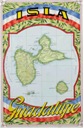 | Details | Raggio, Antonio | 1939 |
| Manuscript map of the Caribbean island of Guadeloupe |
|
Raggio, Antonio |
|
| 1939 |
| LOC:5 |
| $300.00 | Raggio--Antonio | Manuscript-map-of-the-Caribbean-island-of-Guadeloupe | Beautiful manuscript map of Guadeloupe (Isla Guadalupe), part of the Lesser Antilles in the Caribbean Sea. Includes the Isles des Saintes and Maria Galante Island. Fine detail with rivers, mountains, and cities identified. Includes a separate matching fact sheet on the island in Spanish. Both on light card stock.
<br></br>
By Antonio F. Raggio as one in a series of ink and watercolor maps on cards prepared for the Exposicion Filatelica Internacional 11th Congreso de la Union Postal Universal (World Postal Congress), held in Buenos Aires, Argentina in 1939. It is likely that the manuscript cards were proof drawings or models for the engraving of stamps. |
| 1050 |  | Details | Real Escuela de Navegacion | 1735 |
| Early Manuscript plan of Cienfuegos Bay (Puerto de Jagua) |
|
Real Escuela de Navegacion |
|
| 1735 |
| LOC:0 |
| $3,100.00 | Real-Escuela-de-Navegacion | Early-Manuscript-plan-of-Cienfuegos-Bay-(Puerto-de-Jagua) | Pen and ink manuscript port plan of the Bahia de Cienfuegos, Cuba dating to the first half of the 18th century: "Puerto de Jagua". This is the earliest available manuscript plan of that important bay on the south coast of Cuba and is a near perfect copy of a map held in the Library of Congress (https://www.loc.gov/item/91680835/). The existence of multiple manuscript copies of the same chart is explained by the fact that the chart was produced by the Real Escuela de Navegación in Cadiz, whose role was to ensure the accuracy and consistency of maps produced for naval and commercial shipping and to house the growing record of maps and charts related to Spain's vast empire. Copyists at the school would have reproduced numerous identical copies by hand for distribution to military and commerical maritime users. During this time period few maps of Spain's New World possessions were reproduced by printing press, presumeably in order to limit their distribution. Spain's jealous secrecy over their colonial possessions is well documented.
<br></br>
The title and key are located within a frame at lower left; the chart shows coastline, coastal features, soundings, navigational hazards, an anchorage, a few buildings, roads, and streams.
<br></br>
Dating the map depends chiefly on its depiction of the location marked "B"- "lomas estrecho de la entrada" (Translated: Hilly narrow entrance). This site would later become the site of a fort or Castillo (Nuestra Señora de los Ángeles de Jagua) founded in 1745. On this chart, the fact that no mention is made of any structure suggests the map dates to before 1733 when construction on the fort began. On a later manuscript version for example that spot is defined as "es donde esta el Castillo, que es donde estaba la Bateria de ?[Fagina] (Translated: Where the castle is, which is where the Battery of ?? was.")
<br></br>
Note: "jagua" may be translated from Spanish as "Fruit of the custard-apple." |
| 972 |  | Details | Pinot, Charles | 1816 |
| Antique manuscript map of Bagueau and Port-Cros in France's îles d'Hyères |
|
Pinot, Charles |
|
| 1816 |
| LOC:0 |
| $900.00 | Pinot--Charles | Antique-manuscript-map-of-Bagueau-and-Port-Cros-in-France-s-îles-d-Hyères | One of a kind, 200 year-old manuscript topographic map of the French Mediterranean island Île de Bagueau and the north coast of Port-Cros island. Signed and dated within by Ch[arles] Pinot, Director of Fortifications in 1816.
<br></br>
Topograhic detail shown through faint contour lines in pencil with benchmarks and elevation stated in several locations. Three cannon batteries noted in red on Bagueau. On Port-Cros, Pinot noted these features: Presqu'ile de Malalenge, Plage de Jeannet, Batterie Sud, and Chateau Ruine.
<br></br>
Both Île de Bagueau and Port-Cros belong to the îles d'Hyères, a group of four Mediterranean islands off the village of Hyères in the Var department of south-east France. Île de Bagueau at 45 hectares is the smallest of the four islands in the group. Port-Cros, at 650 hectares, is a French national Park.
<br></br>
Signed in French in faint ink: Toulon, 5th October, 1816 The Colonel and Director of Fortifcations Charles Pinot. A note in ink below the title begins: "La partie de terrain marquee…".
<br></br>
With a faint red oval overstamp of the "DEPOT de la Direction des Fortifications DE TOULON" |
| 749 |  | Details | Anonymous | 1846 |
| Antique Manuscript Playbill from the East India Company Ship Herefordshire |
|
Anonymous |
|
| 1846 |
| LOC:1 |
| $2,100.00 | Anonymous | Antique-Manuscript-Playbill-from-the-East-India-Company-Ship-Herefordshire | Very unusual and scarce manuscript theatrical playbill from a known British East India Company trading ship dated within at January 23, 1846.
<br></br>
On long voyages in order to entertain passengers, ships would sometimes offer music, dancing, and plays to make the tedious journey more enjoyable. This rare survivor documents such a theatrical offering aboard the East Indiaman "Herefordshire" as it returned from a voyage that began in London in 1845 and terminated in Bombay, India on Feb. 28, 1846 [1].
<br></br>
The Herefordshire was an old 40-gun, 1600 ton teak-built ship of the East India Company, launched in Bombay in 1812 by John Money. Her Captain was George Richardson.
<br></br>
This rare playbill reads: "THEATRE ROYAL of the HEREFORDSHIRE Under the Distinguished Patronage of the LADIES & CAPTAIN RICHARDSON Jan 23rd 1846. This Evening her Majesty's Servants will perform a New Drama entitled the PENRYN TRAGEDY, with New Scenery, Dresses, &c. </br>
...</br>
...</br>
Act 1st Scene 1st</br>
The Sailors of HER MAJESTY's SHIP Britannia making merry in the Green Dragon.</br>
...</br>
...</br>
The Whole to Conclude with the Popular Farce BILLY BUTTON the TAILOR
...</br>
..</br>
Doors open at 6 o'clock. Performance to commence at 7. For tickets of Admission apply to Mr. Maynard, Stage Manager No. 9 Starboard Terrace, Capstan Square, Gun deck road.
…
<br></br>
This rare, unusual and interesting piece of nautical ephemera should interest collectors of both the theater and nautical history. It is a document from the end of the East India Company's control of India. The East India Company dissolved in 1858 with Britain exerting direct control after the India Rebellion of 1857. Watermarked "Ward and Son. 1842."
<br></br>
[1] "Allen's Indian Mail and Register of Intelligence for British and Foreign India." 1845 and 1846.
</br>
[2] Berncastle, Julius. "A Voyage to China". William Shoberl. London, 1850. |
| 759 |  | Details | Anonymous | 1890 |
| Manuscript page with flags and a chart of British Channel |
|
Anonymous |
|
| 1890 |
| LOC:7 |
| $450.00 | Anonymous | Manuscript-page-with-flags-and-a-chart-of-British-Channel | A small manuscript chart of the English Channel. Decorated at top with the crossed flags of England and France this hand-drawn and hand-colored chart of the British Channel could have been created in the latter half of the 19th century to early 20th century by a British naval student or maritime officer candidate or quite possibly a member of the Sea Cadets Corps or its predecessor, the Naval Lads' Brigade. A legend in English describes features that would be found on a nautical chart of the period such as buoys, rocks, and bearings, but oddly the manuscript map does not contain any of those components with one exception, the Eddystone lighthouse southwest of Plymouth sound.
<br></br>
The most interesting aspect of the chart is the dotted line suggesting the route of a voyage between ports in England and France including Plymouth, Dartmouth, Torquay, Weymouth, Southampton, Sheerness, Cherbourg, and Guernsey
<br></br>
At bottom are drawn three signal flags including the Blue Peter, which was often used when preparing to leave port, or as the caption suggests, when requesting a pilot. Of the other two flags, the center flag is confirmed as a French registration flag that indicates that the vessel was registered to the Cherbourg arondissement sector between Dunkirk and Honfleur. According to Sache:
<div class="indenttextblock">
"French merchant ships had to hoist at foremast a specific flag indicating in which arrondissement they were registered. The French coasts were divided in five metropolitan maritime arrondissements, each of them being divided in two sectors, and in two colonial sectors. The arrondissement flags were established by Royal Regulation of 3 December 1817, signed by Louis XVIII. They were confirmed in the 1852 Imperial Regulations on naval flags signed by Napoléon III and by Decree on 20 March 1868. " </div>
Source: Sache, Ivan. France: Registration flags for merchant ships (1817-1929). Link: flagspot.net/flags/fr~arro.html#che |
| 335 |  | Details | Meyer, C. | 1828 |
| Gibraltar (Manuscript plan) |
|
Meyer, C. |
|
| 1828 |
| LOC:8 |
| $610.00 | Meyer--C- | Gibraltar--(Manuscript-plan) | Unique manuscript military/engineering architectural plan of the Landport (northern) defences of the fortress at Gibraltar from the Inundation, past the Devil's Tongue battery, and the old mole. Two cross sections, one through the north wall (with measurements) and one through the west wall. A high degree of detail shown about the bastions and cannon emplacements. <br></br>
Several dozen measurements in miniscule red script. Contains a small sketch of what appears to be a cave entrance. With watermark "Whatman 1828". Signed "Egina der 7 September 1828 C. Meyer". |