| | Thumbnail | | Creator | Date | Title / Author / Date / Location | Price | | | Description |
| 733 | 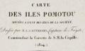 | Details | Duperrey, Louis-Isidore | 1824 |
| Chart of French Polynesia with Tahiti and Bora Bora |
|
Duperrey, Louis-Isidore |
|
| 1824 |
| LOC:59 |
| $575.00 | Duperrey--Louis-Isidore | Chart-of-French-Polynesia-with-Tahiti-and-Bora-Bora | Antique French hydrographic chart with the islands of Pomotou (Tuamotu Islands or French Polynesia). Other names include Archipel Dangereux, Archipel des Pomotou, Archipel des Tuamotu, Tuamotu Archipelago, Tuamotu Islands, and Îles Tuamotu. Includes the Society Islands ( Archipel de la Société ) of Tahiti ( Taiti ), Emeo, Huaheine, Bora Bora and many others and the Toubouai Islands.
<br></br>
Produced by French explorer Louis-Isidore Duperrey (1786-1865). Duperrey served as marine hydrologist to de Freycinet aboard the Uranie and commanded the corvette la Coquille on its westward world circumnavigation during the period 1822–1825 with Jules Dumont d'Urville as second in command. WorldCat only records one copy of this chart- at the Paris Museum National d'Histoire Naturelle.
<br></br>
Contains the tracks of many early voyages through the Pacific islands with dates of discovery for many islands. Discoverers include: Vancouver (1791), Carteret (1767), Bligh and Portlock (1792), Cook (1769), de Bougainville (1768), Lemaire and Schouten (1616) . Number 684. |