| | Thumbnail | | Creator | Date | Title / Author / Date / Location | Price | | | Description |
| 3646 | 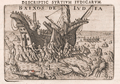 | Details | Langenes, Barent | 1620 |
| Scarce antique print of fantastical lobsters attacking a shipwrecked crew at Ludia |
|
Langenes, Barent |
|
| 1620 |
| LOC:1 |
| $375.00 | Langenes--Barent | Scarce-antique-print-of-fantastical-lobsters-attacking-a-shipwrecked-crew-at-Ludia | Antique copper engraved plate of fantastical crustaceans attacking a shipwrecked crew in the shallows. After van Linschoten's account of the grounding of the ship St. Jacques in 1568 off the island of Ludia near Cabo Corrientes in Mozambique, Africa. The print was first published by Cornelius Claesz and printed by Barent Langenes in 1598. Engraved by Peter van den Keere. Later edition, circa 1620.
<br></br>
Cape Corrientes was regarded by early Portuguese mariners as one of the most terrifying obstacles facing sailing ships in the Indian Ocean. It is named after the exceptionally fast southward current that passes here. It is also a confluence point of winds, with the capacity to produce violent gusts. Guinote estimated that 30% of the ships lost in the yearly Portuguese India Armadas in the 16th and 17th centuries capsized around Cape Corrientes, more than any other location. (Online: https://en.wikipedia.org/wiki/Cape_Correntes) |
| 558 | 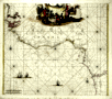 | Details | de Wit, Frederick | 1680 |
| Tractus Littorales Guineae |
|
de Wit, Frederick |
|
| 1680 |
| LOC:54 |
| $1,100.00 | de-Wit--Frederick | Tractus-Littorales-Guineae | Beautiful antique sea chart of north-west Africa. 1680. This chart was created by Frederick de Wit (1630-1706) a Dutch cartographer residing at the time in Amsterdam. A large cartouche at the top shows what is apparently a slave market with captive Africans bound kneeling as strange lizards roam the foreground.
<br></br>
The chart is decorated with images of sailing vessels and with numerous rhumb lines. Coverage extends from Cabo Blanco past cape Verde to the Congo River and beyond. |
| 369 |  | Details | Tirion, Isaac | 1730 |
| Carta Generale Dell Africa |
|
Tirion, Isaac |
|
| 1730 |
| LOC:0 |
| $0.00 | Tirion--Isaac | Carta-Generale-Dell-Africa | SOLD- <BR> </BR>
Highly decorative map of the African continent with the Arabian peninsula, Turkey and Mediterranean. Coverage includes the Indian Ocean, Madagascar, and the Maldives to the east and to the west the Pacific Ocean islands as far as Brasil (Bresil). Decorative cartouche at upper right depicts men hunting a crocodile with elephant and ostrich in the foreground. |
| 582 | 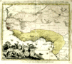 | Details | Homann Heirs | 1743 |
| Guinea propia |
|
Homann Heirs |
|
| 1743 |
| LOC:54 |
| $350.00 | Homann-Heirs | Guinea-propia | Decorative antique map of the West Coast of Africa from 1743 with several regions denoted by outline/wash coloring: Sahara, Ethiopia, Guinea. Map is marked with names of sub-regions, tribal kingdoms, and numerous notations in Latin. Large decorative cartouche at left of map focuses on the daily life of indigenous tribesmen and elephant tusks.
<br></br>
Published by the firm Homann Heirs. Homann Heirs (also "Homannianis Heredibus" or "Homann Erben" or "Heritiers de Homann") was a company established after the death of German cartographer J.B. Homann to carry on the publishing business of the firm he started in the early 1700's. The designation "Homann Heirs" appears on maps published by that successor firm from about 1730 to 1848. |
| 165 |  | Details | Bellin, Jacques Nicolas | 1759 |
| Carte de la Coste Occidentale d'Afrique |
|
Bellin, Jacques Nicolas |
|
| 1759 |
| LOC:6 |
| $110.00 | Bellin--Jacques-Nicolas | Carte-de-la-Coste-Occidentale-d-Afrique | Small chart of the African coast near the bay of Arguim (Arguin) from the Dutch version of Prevost's widely published history originally engraved by Bellin. This copperplate, engraved by J.V. Schley., shows the African coast with both French and Dutch place names. Highlights the island of Arguim which was the site of an important Portuguese trading post / slave fort from which as many as 1000 slaves may have been sold each year. |
| 193 | 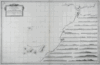 | Details | Varelay Ulloa, Joseph | 1787 |
| Carta Esferica de la Costa de Africa |
|
Varelay Ulloa, Joseph |
|
| 1787 |
| LOC:54 |
| $600.00 | Varelay-Ulloa--Joseph | Carta-Esferica-de-la-Costa-de-Africa | This rare, engraved antique nautical chart of the Northwest coast of Africa was published as part of the first scientific Spanish sea atlas: 'Atlas Maritimo de España' (Maritime Atlas of Spain) by the Dirección de Hidrografía, Spain's equivalent to the U.S. Coast Survey. The antique chart was authored by Spanish naval Captain Don Joseph Varelay Ulloa (ca. 1743-1794) who made several hydrographic surveys of the coast of Africa. With manuscript pencil plots from 1808 centered on Madeira. <BR> </BR>
Coverage from Cape St. Vincent past the Strait of Gibraltar to Cape Bojador in the south including the Canary Islands. Inset with 20 detailed coastal profile views. |
| 279 |  | Details | Malham, John | 1797 |
| A Correct Chart of the Southern Coasts of Africa |
|
Malham, John |
|
| 1797 |
| LOC:0 |
| $0.00 | Malham--John | A-Correct-Chart-of-the-Southern-Coasts-of-Africa | <BR> </BR>
SOLD - <BR> </BR>
Small antique nautical chart showing the continent of Africa south of the Equator and the island of Madagascar. From the rare first American edition of Malham's Naval Gazetteer, published by Spotswood and Nancrede in Boston in 1797. Vol 1.<BR> </BR>
This sea chart comes from an early nautical gazetteer or geographical dictionary produced first in England and after 1796 in the United States. Key noted features from this antique copperplate engraving include Madagascar, Cape of Good Hope, Isle France, Isle Bourbon, . Regional African native tribal associations or kingdoms identified include: Bake-bake, Hotentots, Bororos, Zambas, Nimeamai, Bembei, and Biri.<BR> </BR>
Rev. John Malham was a prolific Yorkshire-born author who produced other diverse works that include "Navigation Made Easy and Familiar", "Twenty-Two Sermons on Doctrinal and Practical Subjects" and "The Scarcity of Wheat considered". Malham died near London in 1807. (Gentleman's Magazine, Vol 102, 1807, p. 568).<BR> </BR>
Colophon at end of Volume 1 states that the work is "From the prefs of Samuel Etheridge, No. 9 Newbury Street, Boston, 1797"). |
| 1165 | 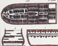 | Details | Wilhelm, Gottlieb Tobias | 1804 |
| Group of antique engravings related to slavery. |
|
Wilhelm, Gottlieb Tobias |
|
| 1804 |
| LOC:0 |
| $250.00 | Wilhelm--Gottlieb-Tobias | Group-of-antique-engravings-related-to-slavery- | A group of three pages containing five hand-colored copper-plate engravings of scenes related to African slaving and slavery.
</br>
<div>
<ul style="margin:2em; list-style-type: circle; line-height: 1.2em;">
<li>Three general-arrangement plans define the three-dimensional distribution of slaves packed in the hold of a slave ship; and vignette of a woman slave in chains working on a coffee plantation with her small children, while behind her another slave is whipped while tied horizontally to a grating. </li>
<li>Two scenes illustrating that Africans were not only slaves but were often complicit in conducting slave raids against other tribes. Black men are shown carrying rifles and assisting in the restraint of naked captives.</li>
<li>Scene showing armed and uniformed Caucasian men rounding up a fugitive slave.</li>
</ul>
</div>
From G. T. Wilhelm's Encyclopedia of Natural History: Mankind. Augsburg, 1804. Gottlieb Tobias Wilhelm (1758-1811) was a Bavarian clergyman and naturalist known as the German Buffon. |
| 7895 | 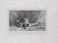 | Details | le Breton, Louis | 1842 |
| Double pirouge in its shed |
|
le Breton, Louis |
|
| 1842 |
| LOC: |
| $200.00 | le-Breton--Louis | Double-pirouge-in-its-shed | Louis Le Breton's lithograph titled "Pirogue double sous son hangar" (which translates to "Double pirogue under its shed") appears in the book "Voyage au pôle Sud et dans l'Océanie sur les corvettes l'Astrolabe et la Zélée" (Voyage to the South Pole and Oceania on the corvettes Astrolabe and Zélée). This book, published in 1841, documents the French naval expedition led by Jules Dumont d'Urville from 1837 to 1840.
<br><br>
The expedition aimed to explore the South Pacific Ocean and the Antarctic region. Le Breton served as a naval surgeon and artist on that expedition, creating numerous illustrations and engravings that were later included in the published account of the voyage. The engraving "Pirogue double sous son hangar" depicts a traditional double canoe (pirogue) from Oceania under a protective shed.
<br><br>
Lithograph by P. Blanchard and printed by Thierry Freres, Paris. |
| 803 | 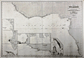 | Details | Robiquet, Aime | 1858 |
| Coast of West Africa |
|
Robiquet, Aime |
|
| 1858 |
| LOC:0 |
| $400.00 | Robiquet--Aime | Coast-of-West-Africa | Large antique steel plate engraved nautical chart of the West coast of Africa from Cape Verga south and west to Cape Ledo. Includes the small offshore islands of Fernando Po, São Tomé , and Principe or "Isle du Prince". Streches of coastline are named after the primary resource exported from the area and include the Gold Coast or "Côte d'Or"; the Ivory Coast or "Côte d'Ivoire"; and the "Côte de Calebar".
<br></br>
At bottom right seven detailed inset harbor plans include: Edina et Grand Bassa, Monrovia et Cape Mesurado, Plan de la Entrée de Sierra Leone, Baie de l'Ouest, Entrée de Vieux Calebar, Cap des Palmes, and Plan du Bassin Exterieur du Gabon. Contains numerous soundings and arrows indicating the primary direction of the current. Relative current strength is indicated by the number of feathers drawn on each arrow.
<br></br>
This antique chart was separately published by French hydrographer and publisher Aime Robiquet. Robiquet is best known as publisher of the "Atlas Hydrographique", a nautical atlas comprised of 75 large charts published from Paris between 1856 and 1861. This chart carries the imprint of Robiquet's oval-shaped blind stamp at the bottom right margin. Number 36. |
| 4907 | 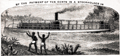 | Details | Henry Reed Steamboat Company | 1887 |
| Rare Missionary Donation Card for Congo River Steamboat |
|
Henry Reed Steamboat Company |
|
| 1887 |
| LOC:41 |
| $350.00 | Henry-Reed-Steamboat-Company | Rare-Missionary-Donation-Card-for-Congo-River-Steamboat | <br />
<div style="text-align: center;font-size:100%;">
"This certifies that <b><i>Mrs. Sara E. Buxton</i></b> <br />by the payment of ten cents <br />is a shareholder in <br /> THE HENRY REED STEAMBOAT COMPANY<br /> for the year 1887"
</div><br />
Recto with scene of a small steam-powered stern-wheel riverboat, a la the African Queen, and two native Africans watching from shore. Map on verso of the Congo Free State, the Congo River, and in the upper Congo River a dotted line shows the route of the Henry Reed. Scarce.
<br /><br />
Very rare "stock certificate" given for a donation of ten cents to support a mission steamer on the upper Congo River in Africa. The vessel "Henry Reed' worked the upper river and after 1887 another steamer joined on the lower Congo River. By 1890 the name of the mission was changed to "The Congo Steamboat Company" and funds collected paid for both vessels as well as for operating expenses. Lifetime membership could be purchased for $1.00. (Baptist Missionary Magazine. American Baptist Missionary Union. Volume 70. Boston. 1890.) |
| 772 | 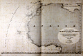 | Details | Direccion Hidrografia | 1939 |
| Spanish sea chart of West Africa |
|
Direccion Hidrografia |
|
| 1939 |
| LOC:0 |
| $325.00 | Direccion-Hidrografia | Spanish-sea-chart-of-West-Africa | Large hydrographic chart of western Africa by Spain's Hydrographic Office, the Direccion de Hidrografia. This chart was originally engraved in 1855 by Serra and updated several times after that; the latest corrections date from 1939. Coverage extends from the islands of São Tomé and Príncipe in the south up as far north as the Strait of Gibraltar and includes the Canary Islands ( Islas Canaria ) and Cape Verde Islands ( Islas de Cabo Verde ).
<br></br>
A later edition of one of four sheets published in Madrid in 1855, that could be joined to cover the entire mid Atlantic Ocean from the Americas to Europe and Africa. Number 212. |