| | Thumbnail | | Creator | Date | Title / Author / Date / Location | Price | | | Description |
| 2572 | 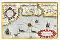 | Details | Waghenaer, Lucas Jansz | 1586 |
| Rare Dutch Sea Chart of The East Coast of England; Newcastle |
|
Waghenaer, Lucas Jansz |
|
| 1586 |
| LOC:9 |
| $2,400.00 | Waghenaer---Lucas-Jansz | Rare-Dutch-Sea-Chart-of-The-East-Coast-of-England;-Newcastle | Rare. Beautiful antique chart of the English North East Coast with the Tyne and Tees Rivers. This fine orginal Dutch chart was printed in 1586, two years before the "Invincible Armada" of Spain was defeated in Spain's attempt to conquer England. The chart is profusely decorated with sailing ships and sea monsters and beautifully engraved by Deutecum.
<br></br>
Includes the Tyne River with Tynemouth and Newcastle; the Tees River with Stockton; Hartlepool, and Sunderland.
<br></br>
With two coastal profiles. From the 1586 Latin edition of Wagenhaers Sphieghel der Zeevaerdt: "Speculum Nauticum". |
| 5105 | 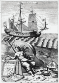 | Details | Blome, Richard | 1685 |
| Original Navigation Engraving by Richard Blome |
|
Blome, Richard |
|
| 1685 |
| LOC:88 |
| $300.00 | Blome--Richard | Original-Navigation-Engraving-by-Richard-Blome | Fine original copper-plate engraving "Navigation" from Gentleman's Recreation by Richard Blome. This plate, as many others in Blome's encyclopedia, was dedicated to an English nobleman. Show's a 17th century square-rigged sailing vessel with charts, a globe, compass and other navigation instruments.
<br></br>
Dedicated to George Legge, Baron of Dartmouth, Master General of the Ordnance and many other titles.
<br></br>
From Blome's "The Gentleman's Recreation. ... An Encyclopedy of the Arts and Sciences ... Horsemanship, Hawking, Hunting, Fowling, Fishing and Agriculture. With a Short Treatise of Cock-Fighting." |
| 792 | 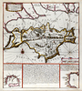 | Details | de Fer, Nicolas | 1692 |
| Isle of Wight, Solent, and South England |
|
de Fer, Nicolas |
|
| 1692 |
| LOC:89 |
| $400.00 | de-Fer--Nicolas | Isle-of-Wight--Solent--and-South-England | Antique nautical chart of the Isle of Wight, the Solent, and part of the south coast of Great Britain by French cartographer Nicolas de Fer. Published in 1692. Noted features of this attractive, colorful sea-chart include: Parkhurst Forest ("Wachinu Park"), the Golfe de Southampton, Pointe de Rames-head, Harve de Hamble, Harve de Rey, Presqu' Isle de Freshwater, Presque Isle de Binbridge, Banc de Mackett, and Spithead. Habitations shown include: Tirchfeild, Newchurch, Portsmouth, Gosport, Worth, Yarmouth, Newport, Helene, Nordwood, Yaverland, and St. Laurens Park. Two insets at bottom depict Tor Baye, and the Scilly Islands ("Isles Solrlingues").
<br></br>
The title cartouche carries the attribution: " A Paris Chez N. de Fer dans l'ile du Palais sur le Quaye de 'lOrloge a la Sphere Royale, aver Priv du Roy, 1692". Published from Paris, France by French geographer and cartographer, Nicolas de Fer (1646 - 1720). De Fer was a prolific producer of maps and prints who among other honors, was appointed as official geographer to the Spanish King in 1702. |
| 790 | 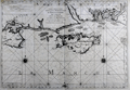 | Details | Jaillot, Alexis-Hubert | 1693 |
| Antique chart of English Coast with Poole, Isle of Wight, Christchurch, Portsmouth |
|
Jaillot, Alexis-Hubert |
|
| 1693 |
| LOC:0 |
| $1,450.00 | Jaillot--Alexis-Hubert | Antique-chart-of-English-Coast-with-Poole--Isle-of-Wight--Christchurch--Portsmouth | Large, bold, antique nautical chart of the south coast of England including portions of the counties of Dorset ( Dorchester ), Hampshire ( Southampton ), and Sussex. Dark, graphically pleasing impression with numerous rhumb lines and three extremely decorative compass roses. Coverage includes Wareham, Brownsea Island, Poole Harbor, Swanage Bay ( Baye de Sandwich ) , Christchurch, Nash, Milford, Lymington, Southampton River, Portsea Island and Portsmouth, Hayling Island, and Thorney Island, and the Harbor of Chichester.
<br></br>
From the NEPTUNE FRANÇOIS, entitled: "Le Neptune François ou Atlas des Cartes Marines Levées et Gravées par Ordre Exprés du Roy. Pour L'usage de Ses Armées de Mer, dans Lequel on Voit la Description Exacte ee Toutes les Côtes de la Mer Oceane, & de la Mer Baltique, Depuis la Norwege Jusques au Detroit de Gibraltar." Published by French royal geographer Alexis-Hubert Jaillot from Paris in 1693. Published with the royal privilege granted by King Louis XIV. Drawn by C. Berey. |
| 5241 |  | Details | Lea, Phillip | 1695 |
| One sheet from The Travelers Guide after Saxtons map of England and Wales |
|
Lea, Phillip |
|
| 1695 |
| LOC:0 |
| $350.00 | Lea--Phillip | One-sheet-from-The-Travelers-Guide-after-Saxtons-map-of-England-and-Wales | Two sheets from Phillip Lea's revised version of Christopher Saxton's large scale map of England and Wales first published in 1583. Shows a portion of Scotland at left; Northumberland (Northumbria), Cumbria (Cumberlandia) and Durham (Dunelmensis). Fifth state published by Philip Lea, Globemaker at ye Atlas and Hercules in Cheapside nere the corner of Fryday Street in London, [1687 - 1700].
<br></br>
Philip Lea re-published Saxton's the map on a smaller scale designed to be used as a travelling map. He reduced the map to ten full sheets and four half sheets. This artifact consists of Lea's top two sheets laid side by side on vellum.
<br></br>
Verso shows English MS text legal document with a date of 1732 visible. Philip Lea re-engraved the plates at least five times during his period of ownership. |
| 3643 | 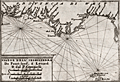 | Details | Coronelli, Vincenzo | 1702 |
| Coronelli's rare chart of England from Portland to the Lizard |
|
Coronelli, Vincenzo |
|
| 1702 |
| LOC:77 |
| $500.00 | Coronelli--Vincenzo | Coronelli-s-rare-chart-of-England-from-Portland-to-the-Lizard | Rare engraved chart from Coronelli's "Teatro della Guerra" shows the east coast of England (Provincia di West) from Portland Bill in Dorset to the Lizard in Cornwall. Features shown include Torbay, Dartmouth, the Isle of Wight and much more. A fine addition to any collection of coastal charts of England.
<br></br>
This small well-engraved antique chart is from the <b>Isole Britanniche</b> volume of the Teatro della Guerra. |
| 996 | 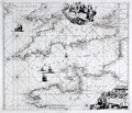 | Details | Renard, Louis | 1715 |
| Renard's decorative sea chart of the English Channel from 1715. |
|
Renard, Louis |
|
| 1715 |
| LOC:50 |
| $1,400.00 | Renard--Louis | Renard-s-decorative-sea-chart-of-the-English-Channel-from-1715- | Fine and scarce copper-engraved sea chart of the <strong>English Channel</strong> from the end of the Dutch Golden Age- a time when Dutch influence, military power, and commerce was at its peak. This very decorative chart "Canalis Angliae et Galliae Littora" was published by Dutch engraver and entrepreneur <strong>Louis Renard</strong>. Two beautiful cartouches, the upper with mythological figures and the lower representing scenes from the world of shipping and commerce with a very affluent, fashionably dressed overseer looking on as plainly-dressed workers go about their tasks.
<br></br>
Louis Renard (1678-1746) was from a Huguenot family. He moved from France to the Netherlands and became a book dealer and publisher in Amsterdam in 1703. This chart is based on an earlier work of Frederick de Wit, from whom Renard purchased the plates. Issued with corrections based on van Keulen, and published in Renard's "Atlas de la Navigation et du Commerce" in 1715. |
| 934 | 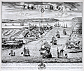 | Details | Kip, Johannes | 1724 |
| Antique birds-eye view of Harwich, England in Essex |
|
Kip, Johannes |
|
| 1724 |
| LOC:0 |
| $0.00 | Kip--Johannes | Antique-birds-eye-view--of-Harwich--England-in-Essex | SOLD
<br></br>
Large, very attractive antique engraved birds-eye view of Harwich, England in the county of Essex. Published in 1724 by well-known British engraver Johannes (Jan) Kip.
<br></br>
Legend at bottom is keyed alphabetically to the important features in the view, specifically:
<div class="indenttextblock">
<ul style="list-style-type:none">
<li>A. The Queen's yard and store house</li>
<li>B. The Queens Key</li>
<li>C. St. Nicholas Church</li>
<li>D. The Towne Hall</li>
<li>E. The Gate leading to London and the Fire Light house over it</li>
<li>F. The Candle Light house</li>
<li>G. Landguard Fort</li>
<li>H. The harbour behind the Towne and the river leading to Maningtree</li>
<li>I. Orvell Station</li>
<li>K. The river leading to Ipswitch</li>
<li>L. The Pacquett Boat (Packet boat)</li>
<li>M. The breakers</li>
<li>N. West street</li>
<li>O. Shotley Gate house</li>
<li>P. Shotley Church</li>
</ul>
</div>
Seller's attribution reads: "Sold by Thomas Taylor at the Golden Lyon near the Horn Tavern, Fleet Street and by Robert Hulton at the corner of Pall Mall over against the Hay Market St. Jameses. |
| 1325 | 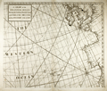 | Details | Cutler and Halley | 1728 |
| Scarce Antique Chart with West Coasts of Europe and Africa |
|
Cutler and Halley |
|
| 1728 |
| LOC:57 |
| $550.00 | Cutler-and-Halley | Scarce-Antique-Chart-with-West-Coasts-of-Europe-and-Africa | Scarce antique chart by Nathaniel Cutler and Edmund Halley, the discoverer of Halley's comet. From "Atlas Maritimus & Commercialis, or a General View of the World, so Far as Relates to Trade and Navigation …". Shows the western coastline of Europe with a broad expanse of the eastern Atlantic Ocean. Includes the "Western Islands" or Azores, Britain, and the western coast of Ireland, Holland, Flanders, Normandy, Brittany, Portugal, Spain, the Strait of Gibraltar, and Morocco.
<br></br>
The sea atlas "Atlas Maritimus" was a collaborative effort of a number of the leading cartographic and scientific names of the era, including English astronomer Sir Edmund Halley, John Senex, Nathaniel Cutler, and Daniel Defoe. The atlas was developed by Senex and Harris to compete with Mount & Page’s English Pilot. Published from London: James and John Knapton et al. |
| 736 | 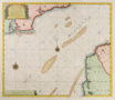 | Details | van Keulen, Gerard | 1730 |
| Dutch chart of the English Channel from Calais to Dover |
|
van Keulen, Gerard |
|
| 1730 |
| LOC:64 |
| $0.00 | van-Keulen--Gerard | Dutch-chart-of-the-English-Channel-from-Calais-to-Dover | SOLD <br></br>
Original antique Dutch nautical chart ca. 1730 of the English Channel by Gerard van Keulen with a title cartouche written in English, French, and Dutch. On the English side of the Channel in Kent the shoreline extends from Rye and Socket with the Rye Camber past Hyth, Sandgate Castle, Dover and Dover Castle, ending at the South Foreland. Just east of the mouth of the Rye is shown a lighthouse on a large sandbar- the Dungeness ( Dungines of Singel ) . This is probably the structure known as 'Lamplough's Tower' originally constructed in 1635 that would have still been standing 100 years later.
<br></br>
Across the Channel the coast of France is shown from Dannes to Pointe d' Alpree, Boulogne, Fort d'Ordre, Ambleteuse, Wissant ( Wisam ) Cap Grines, Cap Blanet, and ends at Calais ( Cales ), France. Features noted on the chart include the Forest d' Mardelot, La Liane, Moulin de Ramseau, Moulin de Coquelle, and Fort Nieulay.
<br></br>
By Gerard van Keulen (1678–1726), son of Johannes van Keulen (d 1715), founder of the Dutch publishing house that produced "the largest and finest marine atlases in Holland". Gerard possessed mathematical, scientific, and engraving skills that enabled him to build the firm started by his father into a substantial and respected business venture. (C. Koeman. "The Sea on Paper: The Story of the Van Keulen's and their 'Sea Torch'." Theatrum Orbis Terrarum Ltd. Amsterdam, 1972). |
| 735 | 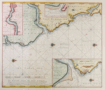 | Details | van Keulen, Gerard | 1730 |
| De Rivier Tyne Of New Castle |
|
van Keulen, Gerard |
|
| 1730 |
| LOC:64 |
| $575.00 | van-Keulen--Gerard | De-Rivier-Tyne-Of-New-Castle | Original detailed Dutch sea chart ca. 1730 of the north-east coast of England from Sunderland and the River Wear in the south to the River Blyth ( Blyt Haven ) in the north. Major geographic areas that Keulen identifies in this antique chart include: The Bishoprik of Durham, Nort ( Noord ) Humberland, and Schotland. With three detailed insets: of the Tyne river to Newcastle on Tyne; the mouth of the Tyne River; and the mouth of the Blyth River. Most place names are in Dutch and some also include their English equivalent. Numerous soundings, aids to navigation, rocks, sandbanks and other hazards along with 4 compass roses and numerous rhumb lines attest to the nautical nature of this working nautical chart.
<br></br>
By Gerard van Keulen (1678–1726), son of Johannes van Keulen (d 1715), founder of the Dutch publishing house that produced "the largest and finest marine atlases in Holland". Gerard possessed mathematical, scientific, and engraving skills that enabled him to build the firm started by his father into a substantial and respected business venture. (C. Koeman. "The Sea on Paper: The Story of the Van Keulen's and their 'Sea Torch'." Theatrum Orbis Terrarum Ltd. Amsterdam, 1972). |
| 741 | 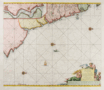 | Details | van Keulen, Gerard | 1730 |
| Antique Chart of northeast England near Newcastle and Tyne River |
|
van Keulen, Gerard |
|
| 1730 |
| LOC:64 |
| $550.00 | van-Keulen--Gerard | Antique-Chart-of-northeast-England-near-Newcastle-and-Tyne-River | Antique Dutch nautical chart depicting the Yorkshire coast of England and Scotland's east coast south of Edinburgh. Contains a detailed inset showing the river Tyne and Newcastle at top left. Coverage of coastal habitations and geographical features includes: Flamborough Head, Filey Bay, Stockton-on-Tees, Newcastle, Hartlepool, Sunderland, the Tyne River, Morpeth, North Berwick, and the entrance to the Firth of Forth ("de Rivier van Eedenborg").
<br></br>
Very decorative title cartouche in Dutch depicts a mermaid and mermen with fishes. The blank area in the North Sea is decorated with a sea serpent, three colorful compass roses, and a square-rigged sailing vessel. North is oriented to the right. Plate 23.
<br></br>
Gerard van Keulen (1678–1726) was the son of Johannes van Keulen (d. 1715), founder of the Dutch publishing house that produced "the largest and finest marine atlases in Holland". Gerard possessed mathematical, scientific, and engraving skills that enabled him to build the firm started by his father into a substantial and respected business venture. (C. Koeman. "The Sea on Paper: The Story of the Van Keulen's and their 'Sea Torch'." Theatrum Orbis Terrarum Ltd. Amsterdam, 1972). |
| 740 | 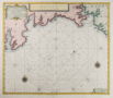 | Details | van Keulen, Gerard | 1730 |
| Antique Nautical Chart of South Cornwall Including Plymouth |
|
van Keulen, Gerard |
|
| 1730 |
| LOC:64 |
| $525.00 | van-Keulen--Gerard | Antique-Nautical-Chart-of-South-Cornwall-Including-Plymouth | Antique Dutch nautical chart of a portion of South Cornwall, England coastline extending from Falmouth in the southwest past Plymouth Sound as far east as Bigbury-on-the Sea. Noted features include Pendennis Castle, St. Mawes Castle, Fay Castle, Palmere, Fovey, Rame Head, Trematon Castle, Eddystone Light, and the Citadel at Plymouth. Published ca. 1730 from Amsterdam by Gerard van Keulen with a title cartouche written in English, and Dutch.
<br></br>
Gerard van Keulen (1678–1726) was the son of Johannes van Keulen (d. 1715), founder of the Dutch publishing house that produced "the largest and finest marine atlases in Holland". Gerard possessed mathematical, scientific, and engraving skills that enabled him to build the firm started by his father into a substantial and respected business venture. (C. Koeman. "The Sea on Paper: The Story of the Van Keulen's and their 'Sea Torch'." Theatrum Orbis Terrarum Ltd. Amsterdam, 1972). |
| 1048 | 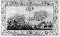 | Details | Pine, John | 1739 |
| John Pine Armada Engraving Plate IX- Calais, France |
|
Pine, John |
|
| 1739 |
| LOC:55 |
| $1,550.00 | Pine--John | John-Pine-Armada-Engraving-Plate-IX--Calais--France | Beautiful intaglio engraving commemorating the defeat of the "Invincible Armada" of Spain by Britain in 1588 during the reign of Elizabeth I. This original antique copper-plate engraving was drawn by Lempriere, engraved and published by <b>John Pine</b> of London in 1739 in his folio volume titled "The Tapestry Hangings of the House of Lords, Representing the Several Engagements between the English and Spanish Fleets in the memorable year MDLXXXVIII".
<br></br>
The battle scene depicts an action on the night of August 7th and 8th, 1588 that marked the key turning point in the campaign. The Spanish Fleet, anchored just offshore the French town of Calais, France was forced to flee after Admiral Howard set fireships ablaze and caused them them to drift down on the anchored Spanish Armada. The fear of explosion and fire so panicked the Spanish Captains that they cut their anchors in haste and scattered in confusion. The scene depicts the fireships between the British fleet at left and the <b>Spanish Armada</b> at right.
<br></br>
Two attributes of Pine's 'Armada" engravings make them very special. First, the great detail, elaborate design and brilliant execution of the work has led these prints to be considered by many to be among the very finest engraved works of the 18th century. Second, the printing process used a two-plate technique that is extremly rare, whereby the interior battle scene was printed separately from the background frame in a beautiful blue-green ink, using an additional plate. The two plate-marks are each clearly visible.
<br></br>
John Pine (1690-1756) was a well respected English engraver and publisher who operated a shop in London and is widely considered to be the finest engraver of his period. At bottom center reads: "Published by John Pine, June 24, 1739 according to an Act of Parliament". |
| 747 |  | Details | Pine, John | 1739 |
| John Pine Armada Engraving Plates III and IV |
|
Pine, John |
|
| 1739 |
| LOC:0 |
| $1,250.00 | Pine--John | John-Pine-Armada-Engraving-Plates-III-and-IV | Stunning, beautifully engraved and deftly hand-colored intaglio engraving commemorating the defeat of the "Invincible Armada" of Spain by Britain in 1588 during the reign of Elizabeth I. This original antique copper-plate engraving was engraved and published by John Pine of London in 1739 in his folio volume titled "The Tapestry Hangings of the House of Lords, Representing the Several Engagements between the English and Spanish Fleets in the memorable year MDLXXXVIII".
<br></br>
Two inset charts depict the actions on July 29 and 30, 1588 when the English Fleet, set sail from Plymouth, England to meet the Spanish Armada in the English Channel. These inset charts show details of both fleets with the Spanish ships formed into a crescent-shaped formation that they felt would offer the best protection and favor their strategy of overpowering the English ships by boarding. The weather played an important role in the English victory, reinforced by drawings of a cherub puffing away.
<br></br>
Two attributes of Pine's 'Armada" engravings make them very special. First, the great detail, elaborate design and brilliant execution of the work has led these prints to be considered by many to be among the very finest engraved works of the 18th century. Second, the printing process used a triple-plate technique that is extremely rare, whereby each of the two inset charts (III and IV) were printed separately from the background in a beautiful blue ink, using an additional plate. The plate-marks of these two insets are clearly visible.
<br></br>
At bottom center reads: ""Published by John Pine, June 24, 1739 according to an Act of Parliament". |
| 842 | 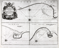 | Details | Collins, Greenvile | 1750 |
| Antique chart of coastal England with Bridlington, Scarborough and Hartlepoole |
|
Collins, Greenvile |
|
| 1750 |
| LOC:0 |
| $240.00 | Collins--Greenvile | Antique-chart-of-coastal-England-with-Bridlington--Scarborough-and-Hartlepoole | Three antique charts of ports on the Yorkshire and Durham coasts of England, including Bridlington ( Burlington ) , Scarborough and Hartlepoole. Coastal areas around these three English ports on the eastern coast of England were important to mid 18th century navigators. The approach to Bridlington in particular would have been particularly hazardous without an accurate chart because of an offshore sandbar ( "Smithic Sand" ) and the nearby promontory of Flamborough Head. The lighthouse shown at Flamborough Head was constructed in 1669 by Sir John Clayton. The current lighthouse dates to 1806.
<br></br>
Dedicated to Captain Ralph Sanderson. From one of the many editions of Greenville Collin's 'Great Britain's Coasting Pilot', published from 1693 to 1792. Number 37. |
| 1354 | 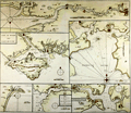 | Details | Collins, Greenvile | 1750 |
| Antique Chart of the Chief Ports of the British Isles |
|
Collins, Greenvile |
|
| 1750 |
| LOC:64 |
| $180.00 | Collins--Greenvile | Antique-Chart-of-the-Chief-Ports-of-the-British-Isles | Antique nautical chart by Collins of seven key ports and harbors in England. These important English locations were dominated by the <b>Thames River</b> with Greenwich, Deptford, and finally upriver- London. Other insets are included for:
<div class="indenttextblock">
<ul style="list-style-type: circle;">
<li>Isle of Wight and Portsmouth</li>
<li>Plimouth Sound [Plymouth]</li>
<li>Portland Bill</li>
<li>Road and Harbour of Dartmouth</li>
<li>Falmouth Harbour</li>
</ul>
</div>
An attractive eighteenth-century engraved nautical chart, with an authentic sea-worn appearance, printed ca. 1750.
<br></br>
From Captain Greenville or Greenvile Collins "Great Britain's Coasting Pilot: being a new and exact survey of the sea-coast of England and Scotland from the river of Thames to the westward and northward ...".
<br></br> |
| 5106 | 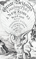 | Details | Collins, Greenvile | 1753 |
| Engraved Frontispiece for Great Britains Coasting Pilot |
|
Collins, Greenvile |
|
| 1753 |
| LOC:88 |
| $350.00 | Collins--Greenvile | Engraved-Frontispiece-for-Great-Britains-Coasting-Pilot | Fine original engraved frontispiece for "Great Britains Coasting Pylot being a new survey of the sea coast by Greenvile Collins Hydrographer to His Majesty." With Poseidon, Britannia, sea nymphs, putti, trumpets, navigation instruments, a chart of the U.K. and one trident. Very attractive.
<br></br>
Sold by William Mount and Thomas Page on Tower Hill, London. |
| 1025 | 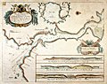 | Details | Collins, Greenvile | 1757 |
| Greenville Collins Chart of the Dart River and Dartmouth, England |
|
Collins, Greenvile |
|
| 1757 |
| LOC:0 |
| $0.00 | Collins--Greenvile | Greenville-Collins-Chart-of-the-Dart-River-and-Dartmouth--England | SOLD <br></br>Attractive, colorful antique nautical chart of the Dart River and the small village of Dartmouth along the western bank. An inset chart of Tarr Bay at top center surrounded by a leafy border. At bottom are three inset coastal elevation views of the entrance to the Dart River as seen from offshore. Notable features include Dartmouth Castle, Kingsward Castle, Old Mill Bay, Combe Point, Blackstone rock, the small village of Dittason, and Gemton Bay.
<br></br>
From one of the many editions of Greenville Collin's 'Great Britain's Coasting Pilot', published from 1693 to 1792. Captain Greenville Collins began his career as an officer in the Royal Navy. Charles II appointed Collins to the role of Hydrographer to the King in 1683 and placed him in command of the Royal yacht, Merlin. Collins was subsequently appointed by Samuel Pepys to record the coastline of Britain. The Merlin is cited as the first British warship dedicated to marine survey work. |
| 1247 | 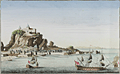 | Details | Huquier, Jacques-Gabriel | 1760 |
| Antique optical print view of the Rock of Gibraltar |
|
Huquier, Jacques-Gabriel |
|
| 1760 |
| LOC:9 |
| $350.00 | Huquier--Jacques-Gabriel | Antique-optical-print-view-of-the-Rock-of-Gibraltar | Lovely vue d'optique or optical print ca. 1760 of the Rock of Gibraltar with the walled city of Gibraltar depicted below. In the foreground ships-of-the-line are shown underway.
<br></br>
Attribution at bottom reads "A Paris ches Huquier Graveur fils rue St. Jacques, au dessus celle des Mathurins au Gd. St. Remy." Jacques Gabriel Huquier (1725 - 1805) was an engraver and printseller located at Rue St. Jacques in Paris, France. Jacques-Gabriel fils was the son of Gabriel Huquier, also a printseller and engraver who worked from the same address. According to Jeffares, Jacques-Gabriel Huquier made a fortuitous marriage in 1758:
<div class="indenttextblock">"[J.G. Huquier] married Anne-Louise, the daughter of the engraver Jacques Chéreau. She brought a dowry of 10,000 livres, mostly in stock in the business at rue Saint-Jacques, “au Grand Saint-Rémy”, and for the next three years with Huquier fils and Chéreau collaborated as engravers and printsellers." <a href="http://www.pastellists.com/Articles/HUQUIER.pdf" target="_blank">Online source.</a>
</div>
By 1772 Huquier had abandoned his family and emigrated to England. |
| 670 | 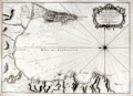 | Details | Bellin, Jacques Nicolas | 1762 |
| Carte de la Baye de Gibraltar |
|
Bellin, Jacques Nicolas |
|
| 1762 |
| LOC:0 |
| $550.00 | Bellin--Jacques-Nicolas | Carte-de-la-Baye-de-Gibraltar | Large, original, antique French sea chart of the Bay and Rock of Gibraltar from 1762. Noted features include the village and mountain of Gibraltar, Fort St. Philippe, Fort St. Roch, Pointe de Mala, Pointe de Roquadillo, the River Entrance Tower ( Tour d'Entre los Rios ), the Admiral's Tower ( Tour de le Amirante ) , Algeciras, Ance de Getare, and Cape Carnero. With numerous soundings, navigational hazards, and anchorages.
<br></br>
Decorative title cartouche attributes the chart to: " le S. Bellin Ingenieur de la Marine Censeur Royal & a." |
| 3675 |  | Details | Bellin, Jacques Nicolas | 1764 |
| Antique chart of the harbor, town, and fort at Plymouth, England |
|
Bellin, Jacques Nicolas |
|
| 1764 |
| LOC:7 |
| $295.00 | Bellin--Jacques-Nicolas | Antique--chart-of-the-harbor--town--and-fort-at-Plymouth--England | Fine mid eighteenth-century French navigation port plan and map of Plymouth, England. By Jacques-Nicolas Bellin. A key with seventeen items provides information on the precise location of important governmental, ecclesiastical, and commercial sites as well a provides the location of major gates or access-control locations. This is a larger-scale plan covering a smaller area than Bellin's related smaller-scale "Carte de la Port de Plimouth" of Plymouth Sound.
<br></br>
From Bellin's <b>Petit Atlas Maritime.</b> Tome IV No 11. |
| 3676 | 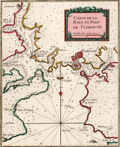 | Details | Bellin, Jacques Nicolas | 1764 |
| Antique chart of Plymouth Sound in England |
|
Bellin, Jacques Nicolas |
|
| 1764 |
| LOC:7 |
| $295.00 | Bellin--Jacques-Nicolas | Antique-chart-of-Plymouth-Sound-in-England | Attractive small French navigation port plan and map of Plymouth Sound and the town of Plymouth, England. By Jacques-Nicolas Bellin. Numerous depth soundings, anchorages, shallow areas, and navigational hazards are noted throughout this fine antique chart.
<br></br>
From Bellin's <b>Petit Atlas Maritime.</b> Tome IV, Number 10. |
| 1046 | 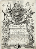 | Details | Ripley, Thomas | 1765 |
| Very rare 1765 trade card for London instrument maker Thomas Ripley. |
|
Ripley, Thomas |
|
| 1765 |
| LOC:0 |
| $0.00 | Ripley--Thomas | Very-rare-1765-trade-card-for-London-instrument-maker-Thomas-Ripley- | SOLD
<br></br>
Very scarce trade card from London-based maker of navigation instruments, <b>Thomas Ripley</b>. This trade card dates from early in Ripley's long career, ca. 1765. In 1765 Ripley operated from an establishement near the Hermitage Bridge, Wapping and was identified with a sign representing a <b>"Globe, Quadrant and Spectacles"</b>. Ripley's own words from the advertisement summarize his business interests:
<div class="indenttextblock">
"Makes & sells all sort of mathematical and Optical Instruments for Sea & Land viz. Hadley & Davis's Quadrants, Azimuth Compasses and steering compasses in wood & brass, Gunters scales, sliding gunters, rules of all sort for measuring & gauging, Cases of Instruments, Plain compasses, Drawing pens, pencils, globes of various sizes, all sorts of telescopes, microscopes, spectacles & reading glasses with various other instruments not here mentioned. N.B. Navigation, books of sorts."
</div>
</br>
Thomas Ripley, born in England about 1740, was a mathematical instrument maker. He was apprenticed to John Gilbert in the Grocers' Company on Dec. 5, 1755, and was free in the Company, April 12, 1763. Ripley married Sarah Susannah Bigg in August 1763 at Saint Botolph Bishopsgate, London. Together they had 9 children, of whom Anna Maria was the youngest.
<br></br>
Thomas Ripley took apprentices, including his son James Ripley, who was his partner from 1800 to 1807. Ripley's business was situated over time in several London locations: in the Baker's Building, New Broad Street (1763 & 1770); at the Globe Quadrant and Sectacles, near Hermitage Bridge below the Tower, Wapping (1765); 364 Hermitage Bridge, below the Tower (1773 & 1794 as Ripley Tho. & Son). (Ripley Family History. <a href="http://belindacohen.tripod.com/ripleyfamilyhistory/" target="_blank">Internet </a>.) |
| 3624 | 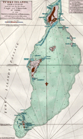 | Details | Jefferys, Thomas | 1775 |
| Antique Chart of the Turks Islands and Turks Islands Passage |
|
Jefferys, Thomas |
|
| 1775 |
| LOC:51 |
| $900.00 | Jefferys--Thomas | Antique-Chart-of-the-Turks-Islands-and-Turks-Islands-Passage | A fine original antique British chart of the <b>Turks Islands</b> in the Caribbean Sea engraved by Thomas Jefferys. Covers Grand Turk Island, Salt Key, Sand Key, Cotton Island, Pelicans Island, and others in the vicinity. A foundational map for collectors, it is the earliest obtainable sea chart to focus solely on the Turks Islands, today a British Overseas Territory. (Note: The Caicos Islands are not included on this chart.)
<br></br>
Shows rocks, banks, reefs, shoals, anchorages, "Salt Rakers Huts" on the 2 main islands, rhumb lines. Printing done from a hand-engraved copper plate by Jefferys.
<br></br>
At Sand Key at point "A", on the Southern Bluff, a note reveals <div class="indenttextblock"> " Upon this bluff (Sand Key) the French, after the late Peace, erected a Sea Mark which they were soon obliged to demolish."</div>
<BR/>
The chart is from the scarce <b>first edition of the West India Atlas" 1775 by Sayer</b>, the other issues being 1781, 1787, 1794, 1796, 1807, and 1818 published by Sayer and then Laurie and Whittle. <a href="https://www.davidrumsey.com/home" target="_blank">(Online).</a>
<br></br>
From: "The West-India Atlas: or, A Compendious Description of the West-Indies: illustrated with Forty Correct Charts and Maps, taken from Actual Surveys. Together with An Historical Account of the Several Countries and Islands which compose that part of the world. Their Discovery, Situation, Extent, Boundaries, Product, Trade, Inhabitants, Strength, Government, Religion, &c."
Author: Thomas Jefferys.
Publishers: Robert Sayer.
Jefferys died in 1771; Sayer acquired Jefferys' materials in preparation for this atlas, and published the atlas posthumously under his name. |
| 6668 | 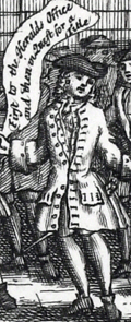 | Details | Bowles, Carington | 1785 |
| Bubblers Medley rare South Sea Bubble satirical etching |
|
Bowles, Carington |
|
| 1785 |
| LOC:1 |
| $0.00 | Bowles--Carington | Bubblers-Medley-rare-South-Sea-Bubble-satirical-etching | SOLD<br><br>"The Bubbler's Medley, or a Sketch of the Times: Being Europe's Memorial for the Year 1720" is a trompe l’oeil-style satirical print published by Carington Bowles (1724-1793) from London ca 1785. At top center this plate shows an unsuccessful speculator staring out from behind the bars of a debtors prison. Bottom center with the text of "A South Seas Ballad", a satirical poem by Jonathan Swift, written in response to the South Sea Bubble financial crisis. It criticizes the greed and folly of investors who were caught up in the speculative frenzy. One of several re-issues, this on wove paper thus ca. 1780 - 1790. Page 23.
<br><br>
<div id="0" align="center">
<a title=""></a> <img id="3" src="/zoomifyimages/SC_6668/SC_6668_Debtor.jpg" alt="Bowles' Debtor's Medley detail" width="300"/> <br><small>"Behold a poor dejected wretch<br>Who kept a sea-coach of late" ...</small>
</div>
<br>
In 1720, England experienced a financial crisis known as the South Sea Bubble. The South Sea Company was established in 1711 to consolidate and decrease the cost of the national debt. Its main business was initially to supply African slaves to the islands in the "South Seas" and South America, although this trade did not yield significant profits. Instead, the company expanded its operations to deal in government debt, and this led to the creation of a notorious economic bubble that ultimately collapsed suddenly, resulting in the ruin of numerous investors and a decline in the national economy.
<br><br>
<div id="0" align="center">
<a title=""></a> <img id="3" src="/zoomifyimages/SC_6668/SC_6668_Detail.jpg" alt="Bowles' Debtor's Medley detail with speech scrolls" width="300"/> <br><small>"A numerous family ruin'd without Remedy" ...</small>
</div> |
| 5128 |  | Details | Laurie and Whittle | 1795 |
| Original Rare 18th Century Heraldic Print A Chart of Blazonry |
|
Laurie and Whittle |
|
| 1795 |
| LOC:62 |
| $1,800.00 | Laurie-and-Whittle | Original-Rare-18th-Century-Heraldic-Print-A-Chart-of-Blazonry | A Chart of Blazonry. Engraved pictorial chart, uncolored, of the components of a blazon or heraldic device. The chart is essentially a reference work, a visual dictionary that allows the conversion of textual descriptions of a blazon into its visual image.
<br></br>
Rare. No copies found anywhere online.
<br></br>
Blazonry, a part of heraldry, is the formal description or illustration of coats of arms. Blazonry embodies a grammar and vocabulary which describe the meaning of a blazon. The field of heraldry, of ancient origin, is the system by which coats of arms and other armorial bearings are devised, displayed, described, recorded and granted.
<br></br>
Published on March 30, 1795 by Laurie and Whittle no. 53 Fleet Street, London.
<br></br>
Engraved by Robinson |
| 1243 | 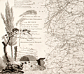 | Details | Wells and Harris | 1798 |
| Scarce 18th century map of the River Thames with roads, rivers, and canals |
|
Wells and Harris |
|
| 1798 |
| LOC:0 |
| $0.00 | Wells-and-Harris | Scarce-18th-century-map-of-the-River-Thames-with-roads--rivers--and-canals | SOLD<BR></BR>
Scarce and attractive 3 foot long antique map of the <b>River Thames</b> from its mouth to its source at the Severn River. This marvelously detailed beauty records the transportation routes near the Thames River and London at the end of the 18th century. Mail coach roads, common stage roads, rivers and canals are meticulouly recorded and may be identifed by referring to a visual index at top left. All market towns are notated with the number of miles they lie from the Royal Exchange (Ex: Salisbury 84; Chippenham 96; Colchester 51). Major canals are named and annotated with their year of construction (Ex: Basingstoke Canal 1772; Braunston Grand Junction Canal 1793).
<br></br>
<b>No record of a sale of this map is found in the Antique Map Price Record (AMPR)</b> nor are any examples of the map for sale or catalogued online except for ONE COPY recorded at the British Library.
<br></br>
Scenic cartouche at right showns a tranquil, shady scene with water gushing out of a tunnel, overflowing a spillway
<br></br>
Published March 10, 1798 by L.B. Wells, No 26 Leadenhall Street J. Harris Sweetings Alley Royal Exchange and at No. 54 Tottenham Court Road. |
| 1263 | 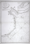 | Details | Depot de la Marine | 1798 |
| Antique French chart of the mouth of the Humber River in England |
|
Depot de la Marine |
|
| 1798 |
| LOC:0 |
| $465.00 | Depot-de-la-Marine | Antique-French-chart-of-the-mouth-of-the-Humber-River-in-England | Antique nautical chart includes some of the west coast of England with portions of Norfolk and Lincolnshire counties. Points charted on this old nautical artifact extend from Lowestoff in the south past Yarmouth, Lynn Regis, Wainfleet and Saltfleet; terminating in the north past Grimsby.
<br></br>
With the circular logo of France's Depot de la Marine with "R.F." used during the period immdiately after of the French Revolution . |
| 888 | 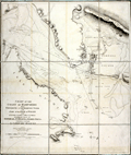 | Details | Knight, John | 1799 |
| Antique nautical chart of the coast of Hampshire, England from Portsmouth to Southampton Water |
|
Knight, John |
|
| 1799 |
| LOC:0 |
| $0.00 | Knight--John | Antique-nautical-chart-of-the-coast-of-Hampshire--England-from-Portsmouth-to-Southampton-Water | SOLD<br></br>
Antique folding sea chart of the Coast of Hampshire, England from Portsmouth to Southampton. With the northwest portion of the Isle of Wight and <b>Portsmouth Harbor</b>. Coverage includes the noted features of Calshot Castle, Gosport, Fareham, Porchester Castle, Hilsea Barracks, Langston Harbor, Portsea Island, <b>Spithead</b>, South Sea Castle, Cumberland Fort. Fort Monckton, Culver Cliffs, and Stokes Bay. Numerous sand banks are identified including Dean Sand, Horse Sand, Spit Bank, Bembridge Ledge, Mother Bank, and Bramble. With numerous soundings, buoys, anchorages and bearing lines.
<br></br>
Based on the surveys of <b>Captain John Knight, R.N.</b> (1747 - 1831) and published by William Faden from London in 1799. In 1815, after ten years commanding the garrison on Gibraltar, Captain Knight retired a full admiral to Woodend House in Soberton, Hampshire about 10 miles north of the area covered by this chart.
<br></br>
Dissected into nine segments and laid to linen with light blue satin selvage. London. Published by W Faden Geographer to His Majesty and to H.R.H. the Prince of Wales. Charing Cross, January 1, 1799. |
| 5169 | 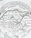 | Details | Anonymous | 1800 |
| Antique plan of the intended navigable canal from Leeds to Selby. |
|
Anonymous |
|
| 1800 |
| LOC:64 |
| $800.00 | Anonymous | Antique-plan-of-the-intended-navigable-canal-from-Leeds-to-Selby- | <br>Unrecorded map</b> ca. 1774 (but printed early 19th C.?) of a proposed canal in England from the town of Leeds to Selby. Probably after the survey of John Longbotham who is reported to have been employed to survey the route.
<br></br>
The Leeds and Selby Canal would connect with another waterway, the Leeds to Liverpool Canal, then under construction. The canal was proposed to reduce the time and costs to ship bulky items between the two towns which were currently served by boats over the winding course of the River Aire.
<br></br>
The canal proposal ultimately was defeated in Parliament and the shorter Selby Canal was built to Haddesley on the Aire in 1778.
<br></br>
Similar to but much larger (28" x 13") than an anonymous map of the same name published in the Gentleman's Magazine in 1774 (~ 8" x 13"). With two tables of distances, a table of references to the River Calder and a table of references to the River Aire.
<br></br>
Fine circular inset context map centered on York showing the towns, villages and waterways. Title on the inset reads:
<div class="indenttextblocksingle">
"A map of 40 miles round York shewing the advantageous situation of that city in a fertile country abounding with every convenience for the support of trade which would be greatly improved from the center to the utmost limits by making a canal navigation from Leeds to Selby."
</div>
</br>
On wove paper, with evident platemark. Unattributed. |
| 897 | 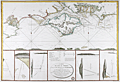 | Details | Depot de la Marine | 1803 |
| Attractive antique chart of the Isle of Wight and Portsmouth, England |
|
Depot de la Marine |
|
| 1803 |
| LOC:64 |
| $720.00 | Depot-de-la-Marine | Attractive-antique-chart-of-the-Isle-of-Wight-and-Portsmouth--England | Attractive French copperplate engraved sea chart of the <b>Isle of Wight</b> and Hampshire coast of England after a chart of 1800 by Captain William Price. This spectacular antique chart is packed with interesting observations that are now over 200 years old. On the main, upper chart numerous soundings, buoys, current indicators, and sandbanks are displayed along with seven inset coastal recognition elevation views to include the Needles, Ash Down Beacon, and Dunnose.
<br></br>
Towns, villages, and other noted features include: St. Aldan's Head, Poole, Christ-church, Lymington, Portsmouth, Portchester, Brackelsome Bay, Chelsea Bill, Brading, Blackgang Chin, Wacht House, Spithead, Sandown Bay, Chichester, and Cowes.
<br></br>
Central inset contains an oval title cartouche and a description of local buoys with the water depths at each. These named buoys include <b>Royal George</b> (a first-rate British ship-of-the-line lost off Portsmouth while at anchor in August 1782) , Edgar, Normansland, Bembridge Ledge, Knab Rock and the Horse and Dean Sands. Flanking the central inset are five attractive detailed elevation views with bearings <b>triangulating buoys to on-shore features</b>, usually prominent houses, beacons, or hills. These bearings are often accompanied with sailing directions in French such as this one indicating an anchorage with a 3-masted sailing ship at anchor. It triangulates a compass heading with a white marker on the Isle of Wight to a windmill on Portsea Island. <div class="indenttextblock"> "La Chapelle dans Portsmouth Common et le Moulin dans l'est du Chateau de South Sea l'un par l'autre N 14 NE".</div>
</br>
Published by order of Contre-Amiral (Rear Admiral) Decres in An XII (year 12) of the French Revolution which is equivalent to 1803. With the circular logo of an anchor surrounded by "R.F." (REPUBLIQUE FRANÇAISE) used by the Depot during the revolution. Price when published was two Francs. |
| 1061 | 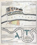 | Details | House of Commons | 1803 |
| 1803 plans of the Thames River docks and proposed construction |
|
House of Commons |
|
| 1803 |
| LOC:89 |
| $425.00 | House-of-Commons | 1803-plans-of-the-Thames-River-docks-and-proposed-construction | Two plans from early 1800's of the docks along the River Thames, the upper plan showing the Thames between London Bridge and the Tower of London. Lower map showing from London Bridge downstream past the Isle of Dogs. Part of the area now comprises the London Docklands, a center for redevelopment and urban renewal. Includes the location of the recently constructed Canary Wharf business district in the bend of the Thames River called the Isle of Dogs (once referred to as Stepney Marsh).
<br></br>
Two hand-colored maps of one sheet: a) Extension of the legal quays &c. and b) Plan of the River Thames with the proposed docks at Rotherhithe and in the Isle of Dogs for 814 ships with room for shifting and lighters.
<br></br>
Sourced from Appendix 3 and 4 of volume XIV of the Report (1796) "On Providing Accommodation for the Trade and Shipping of the Port of London". The report, ordered by the House of Commons was printed in 1796 and reprinted in 1803 by Luke Hansard and Sons, printers. |
| 8019 |  | Details | Taylor, Joseph | 1814 |
| Land Travelers Pocket Compass of Winds and Weather |
|
Taylor, Joseph |
|
| 1814 |
| LOC:78 |
| $550.00 | Taylor--Joseph | Land-Travelers-Pocket-Compass-of-Winds-and-Weather | Early 19th-century "Land Traveller's Pocket Compass," engraved and issued by Joseph Taylor. This is only the second example of this work by Taylor we can locate. No example of the item is found in WorldCat.
<br><br>Taylor prepared these pocket compasses for travelers, surveyors, and outdoorsmen who needed a simple guide for direction finding and basic weather prediction. The circular diagram is built from several engraved rings of text explaining how rainbow color, phase of the moon, and compass bearing of specific meteorological phenomena (wind, clouds, rain) were believed to signal approaching changes in the weather. These ideas reflect the early folk-meteorological rules that Taylor promoted in his printed work: "A rain-bow in the morning is the Shepherd's warning; but a rain-bow at night is the shepherd's delight."
<br><br>
Published for J. Taylor in 1814. With a manuscript dedication at bottom right: "From your lonely husband in Britain. 1943."
<br><br>
The piece blends practical instruction with decorative engraving. The central compass rose is surrounded by Taylor's explanatory text, while two ribbon panels carry short rules for reading clouds and winds. Although inexpensive and meant for everyday use, few examples survive because they were handled, carried, and eventually discarded. This sheet is therefore a rare artifact of early British scientific engraving and an unusual example of Joseph Taylor's work at the intersection of silversmithing, printing, and popular science. |
| 6490 | 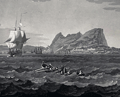 | Details | Hegi, Franz | 1830 |
| Aquatint view of Gibraltar as seen from offshore |
|
Hegi, Franz |
|
| 1830 |
| LOC:86 |
| $300.00 | Hegi--Franz | Aquatint-view-of-Gibraltar-as-seen-from-offshore | Acquaint engraved view of Gibraltar in 1830 as seen from offshore by Franz Hegi (1774 - 1850). B&W on wove paper. 22" x 17" within the platemark.
<br><br>
French credits at bottom: "Peint par Noël, Gravé par Fr. Hegi. Imprimé par Schweizer, à Paris chez M. Bance ainé rue St. Denis No.214. |
| 1006 |  | Details | Holden, George | 1843 |
| Approaches to Liverpool 1843 |
|
Holden, George |
|
| 1843 |
| LOC:0 |
| $0.00 | Holden--George | Approaches-to-Liverpool-1843 | SOLD
<br></br>
Scarce, well illustrated, and very 'nautical' chart of Liverpool Bay and the Mersey estuary with the entrance to the Mersey River. An unusual, information-dense navigational chart from 1843 of the Mersey Estuary packed with details on buoys, lights, channels, range markers, soundings and sailing directions. The chart is surrounded by enlarged profile views of lights, lightships, and range marks to aid in their identification. Working clockwise from top right these objects include: Bootle Marks, Rock Light, Leasowe Light, N.W. Formby, N.W. Lightship, Formby Lightship, Crosby Lightship, Bell Beacon, Hoylake lower and upper light, Bidston Light, New C. Mark, Crosby Light, Point of Ayre Light, and S.E. Mark.
<br></br>
Verso with a view attributed to B.C. Watts showing the arrangement of general communications signals about the lighthouses, made by hoisting flags, pendants, or balls to poles each with a specific purpose.
<br></br> |
| 749 |  | Details | Anonymous | 1846 |
| Antique Manuscript Playbill from the East India Company Ship Herefordshire |
|
Anonymous |
|
| 1846 |
| LOC:1 |
| $2,100.00 | Anonymous | Antique-Manuscript-Playbill-from-the-East-India-Company-Ship-Herefordshire | Very unusual and scarce manuscript theatrical playbill from a known British East India Company trading ship dated within at January 23, 1846.
<br></br>
On long voyages in order to entertain passengers, ships would sometimes offer music, dancing, and plays to make the tedious journey more enjoyable. This rare survivor documents such a theatrical offering aboard the East Indiaman "Herefordshire" as it returned from a voyage that began in London in 1845 and terminated in Bombay, India on Feb. 28, 1846 [1].
<br></br>
The Herefordshire was an old 40-gun, 1600 ton teak-built ship of the East India Company, launched in Bombay in 1812 by John Money. Her Captain was George Richardson.
<br></br>
This rare playbill reads: "THEATRE ROYAL of the HEREFORDSHIRE Under the Distinguished Patronage of the LADIES & CAPTAIN RICHARDSON Jan 23rd 1846. This Evening her Majesty's Servants will perform a New Drama entitled the PENRYN TRAGEDY, with New Scenery, Dresses, &c. </br>
...</br>
...</br>
Act 1st Scene 1st</br>
The Sailors of HER MAJESTY's SHIP Britannia making merry in the Green Dragon.</br>
...</br>
...</br>
The Whole to Conclude with the Popular Farce BILLY BUTTON the TAILOR
...</br>
..</br>
Doors open at 6 o'clock. Performance to commence at 7. For tickets of Admission apply to Mr. Maynard, Stage Manager No. 9 Starboard Terrace, Capstan Square, Gun deck road.
…
<br></br>
This rare, unusual and interesting piece of nautical ephemera should interest collectors of both the theater and nautical history. It is a document from the end of the East India Company's control of India. The East India Company dissolved in 1858 with Britain exerting direct control after the India Rebellion of 1857. Watermarked "Ward and Son. 1842."
<br></br>
[1] "Allen's Indian Mail and Register of Intelligence for British and Foreign India." 1845 and 1846.
</br>
[2] Berncastle, Julius. "A Voyage to China". William Shoberl. London, 1850. |
| 979 |  | Details | Hartley, Jesse | 1848 |
| Plan of the Liverpool docks in Lancashire County, England |
|
Hartley, Jesse |
|
| 1848 |
| LOC:0 |
| $250.00 | Hartley--Jesse | Plan-of-the-Liverpool-docks-in-Lancashire-County--England | A long mid 19th-century hand-colored folding plan of the Liverpool Docks along the Mersey River in England. After a manuscript plan by Jesse Hartley (1780-1860). Shows the relative positions of the docks with their related canals and locks and through color coding shows the stage of development from proposal, though construction, to imnplementation.
<br></br>
By Jesse Hartley who was the world's first professional dock engineer, and is credited with creating a fireproof cast iron framed warehouse design used in building the Albert Dock at Liverpool. The Albert Dock, a complex of warehouses and dock buildings was the first structure in Britain to be built entirely of cast iron, brick, and stone, and was considered innovative at the time because it allowed ships to load and unload directly to the warehouses. (Merseyside Maritime Museum. "Creator of the dock, Jesse Hartley". <a href="http://www.liverpoolmuseums.org.uk/maritime/about/jesse-hartley.aspx" target="_blank">Internet</a>.)
<br></br>
C.B. Graham, Lithographer. Washington D.C. |
| 1257 |  | Details | Corporation of Trinity House | 1849 |
| Antique Booklet for the Trinity House School in Hull for the Sons of Seamen |
|
Corporation of Trinity House |
|
| 1849 |
| LOC:41 |
| $195.00 | Corporation-of-Trinity-House | Antique-Booklet-for-the-Trinity-House-School-in-Hull-for-the-Sons-of-Seamen | Very scarce 14-page booklet containing the Rules and Regulations for the Marine School operated at Kingston-Upon-Hull by the <b>Trinity House</b> for the education of the sons of seamen from that port. On period wove paper.
<br></br>
The Trinity House was originally a guild of shipmen and mariners established by Henry VIII in 1517 to support and expand shipping in England. Later the Trinity House was tasked with maintaining buoys, lighthouses, and aids to navigation on the English coast as well as licensing ship's pilots. (Oxford Companion to Ships and The Sea, Peter Kemp, ed. Oxford University Press. London, 1976, p. 889.)
<br></br>
Printed in 1849 for R.T. Cussons, Lowgate, Hull. |
| 732 | 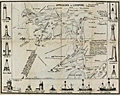 | Details | Holden, George | 1850 |
| Approaches to Liverpool 1850 |
|
Holden, George |
|
| 1850 |
| LOC:0 |
| $0.00 | Holden--George | Approaches-to-Liverpool-1850 | SOLD<br></br>Scarce, well illustrated, and very 'nautical' chart of Liverpool Bay and the Mersey estuary with the entrance to the Mersey River. An unusual, information-dense navigational chart from 1850 of the Mersey Estuary packed with details on buoys, lights, channels, range markers, soundings and sailing directions. The chart is surrounded by enlarged profile views of lights, lightships, and range marks to aid in their identification. Working clockwise from top right these objects include: Bootle Marks, Rock Light, Leasowe Light, N.W. Formby, N.W. Lightship, Formby Lightship, Crosby Lightship, Bell Beacon, Hoylake lower and upper light, Bidston Light, New C. Mark, Crosby Light, Point of Ayre Light, and S.E. Mark.
<br></br>
Verso with a view attributed to B.C. Watts showing the arrangement of general communications signals about the lighthouses, made by hoisting flags, pendants, or balls to poles each with a specific purpose.
<br></br>
The above chart was issued with and folds into "Holden's Original Pocket Almanac and Tide Table, 1851" (3" x 5") included in the price. Along with tide tables, the Almanack includes information on distances to places on the river, life-boat stations, pilot-boats, widths of dock entrances and several dozen more types of information that would be useful to mariners or ship-owners.
<br></br>
In worn, blue paper covers, with intact and tight pages. The chart is loose but in good condition. Engraved and printed by J.B. Leatherbarrow, South John Street, Liverpool. Sold by Thomas Kaye, Castle-street. |
| 763 | 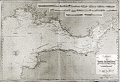 | Details | Robiquet, Aime | 1850 |
| Antique Chart of the Bristol Channel in England |
|
Robiquet, Aime |
|
| 1850 |
| LOC:0 |
| $350.00 | Robiquet--Aime | Antique-Chart-of-the-Bristol-Channel-in-England | Antique French hydrographic chart of southwest Wales and England surrounding the Bristol Channel. Coverage extends from Stackpole clockwise past Swansea, Barry, Cardiff, to Bristol, and moving south-westward to Portishead, Burnham, Bridgewater, Watchet, Minehead, Ilfracomb, Barnstaple, terminating at Kilkhampton. This is a privately published chart by Aime Robiquet, a French Hydrographer, but based on work by Denham and Robinson for an earlier British Admiralty chart. Inset at upper right contains numerous profile coastal views. Interesting small oval blind stamp by Robiquet at bottom right margin.
<br></br>
Numerous soundings, aids to navigation, compass course notations, current flows, and navigational hazards are noted.
<br></br>
This large nautical chart was published by Robiquet in the 'Atlas Hydrographique, one of 75 charts published in that atlas from in 1856. Rue Pavée Saint-André des Artes No. 2, Paris, France. Printed by Mangean, rue St Jacques. Price when issued was four francs. Number 9. |
| 1013 |  | Details | Taylor, Janet | 1850 |
| Trade Card for Janet Taylor, early author and teacher of navigation |
|
Taylor, Janet |
|
| 1850 |
| LOC:0 |
| $0.00 | Taylor--Janet | Trade-Card-for-Janet-Taylor--early-author-and-teacher-of-navigation | SOLD<br></br>
Rare trade card ca. for Janet Taylor (née Ionn) who operated a Nautical Academy and Warehouse at 104 Minories in London "opposite the rail road" from 1835 - 1859. Taylor advertised as a "Mathematical Instrument, Chart, Map, & Bookseller".
<br></br>
Her academic and scientific achievements are many, particularly for a female in the mid-19th century. According to one online source, Janet Taylor was "...the only woman in the 2,200 entries in <i>The Mathematical Practitioners of Hanoverian England 1714-1840". </i> Taylor invented the Mariner's Calculator in 1834 which enabled navigators to find <div class="indenttextblock">" ‘the true Time’,’the true Altitude’, ‘the true Azimuth’, and ‘Latitude by double Latitudes and elapsed Time’". </div><a href="https://middlesavagery.wordpress.com/2012/10/16/archaeology-ada-lovelace-day-mrs-janet-taylor-and-the-dividers/" target="_blank">(Internet)</a>.
<br></br>
She was recommend by the British Admiralty, Trinity House, the British East India Company, and was an agent for sales of Admiralty charts. Taylor authored "Epitome of Navigation and Nautical Astronomy" published through 11 editions from 1842 and 1858.
(Bruck, Mary. "Women in Early British and Irish Astronomy: Stars and Satellites". pp. 52-54. Springer, 2009. <a href="https://books.google.com/books?id=12CnfM1u32kC&pg=PA52&lpg=PA52&dq=janet+taylor+navigation+warehouse&source=bl&ots=TYT5GXCUVb&sig=6wY5YQDprYF3HH7K-t0RnzqdVg8&hl=en&sa=X&ved=0ahUKEwjEiZGnrK_KAhXK7SYKHTxvAHYQ6AEIKTAB#v=onepage&q=janet%20taylor%20navigation%20warehouse&f=false" target="_blank">Internet</a>). |
| 1045 |  | Details | Zawitz, Verlag v.w. | 1850 |
| Lithograph of the British warship Wellington |
|
Zawitz, Verlag v.w. |
|
| 1850 |
| LOC:1 |
| $375.00 | Zawitz--Verlag-v-w- | Lithograph-of-the-British-warship-Wellington | Attractive German lithograph of the 3-decked 74-gunBritish ship of the line "HMS Wellington" with auxiliary steam power. Published by Verlag v.w. Zawitz in Berlin ca. 1850. |
| 1054 |  | Details | Gillray, James | 1851 |
| Fighting for the Dunghill |
|
Gillray, James |
|
| 1851 |
| LOC:0 |
| $0.00 | Gillray--James | Fighting-for-the-Dunghill | SOLD
<br></br>Re-strike satirical copperplate engraving of Gillray's famed "Fighting over the Dunghill". This caricature is by one of England's finest 18th century artists and satirists, James Gillray. Printed after Gillray's death from the original plate this engraving (recto) shows two colossal national figures sitting on the globe, Jack Tar, plump and hearty representing Britain, boxing an emaciated, half-naked Frenchman, possibly Napoleon, who has blood spouting from his nose, his torso and limbs heavily scarred with the tattooed name "Nelson", a British naval hero.
<br></br>
Hand-coloured etching with aquatint and attractive hand-coloring.
<br></br>
Originally published in 1798 by Hannah Humphrey this plate is from the Henry Bohn restrikes printed from the original plates during 1845 to 1851. Printed on both sides of heavy wove paper, the verso contains an unusable engraving due to trimming of the engraving on the recto. |
| 1105 | 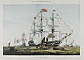 | Details | Illustrated London News | 1856 |
| The James Watt Man of War |
|
Illustrated London News |
|
| 1856 |
| LOC:9 |
| $145.00 | Illustrated-London-News | The-James-Watt-Man-of-War | Colorful lithograph of the twin decked ship-of-the line James Watt, a sail and steam powered vessel. In celebration of the queen's birthday sailors man the yards and cannons are fired in salute. Published by the Illustrated London News July 26, 1856. |
| 910 | 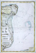 | Details | Depot de la Marine | 1871 |
| Antique nautical chart of coastal Kent, England from Dover to Margate |
|
Depot de la Marine |
|
| 1871 |
| LOC:64 |
| $875.00 | Depot-de-la-Marine | Antique-nautical-chart-of-coastal-Kent--England-from-Dover-to-Margate | Very attractive 1871 edition of an antique nautical chart of the coast of <b>Kent, England</b> including the towns of Dover, Deal, Sandwich, Ramsgate, Broadstairs, and Margate; originally issued in 1866.
Carefully hand-colored, this fine French Sea chart is a fabulous example of the value and appeal that coloring can add to a chart. This chart would make a fine gift for any sailor or fisherman who travels those waters.
<br></br>
Numerous attractive inset elevation views of the coast and drawings of navigational aids. These inset views include the Balise du Godwin Safety (a balise was an elevated signal fire); three lighthouses: "Feu de North Foreland", "Feu de Ramsgate", "Feu Superieur de South Foreland"; and seven extremely decorative profile views of the coast with homes, mills, churches and towers as they existed in 1866. These fine coastal elevation views include: Pugin's Tower; Broadstairs North Cliff with the Ramsgate jetty below; the Deal wharf with Old Parker's Cap in the background; a single view with Kingsdown Church in alignment with Ripple Mill and Walmer Castle aligned to the Upper Deal Mill; Old Stairs Bay; the Admiral's wharf with Shakespeare Cliff; and finally at the upper right, a long profile that includes Saint Lawrence Church, Ramsgate Church, the North Down monument and Redding Street balise.
<br></br>
Includes the dangerous North Goodwin Sands offshore the coast protected by these lightships: "Feu FixeSouth Sand Head", "Feu Floyttant de la Pt. N. du Goodwin" and "Gulf Stream Feu tournant de 20 s and 20 s"
<br></br>
Published by France's Depot des Cartes et Plans de la Marine with corrections in 1871 based on an earlier work from 1866 by the British Admiralty. Number 2410. Contains a blue ink over-stamp from the seller "Au Semaphore" in Havre. |
| 911 | 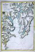 | Details | Depot de la Marine | 1871 |
| Antique nautical chart of the Bay and Port of Falmouth, England |
|
Depot de la Marine |
|
| 1871 |
| LOC:64 |
| $825.00 | Depot-de-la-Marine | Antique-nautical-chart-of-the-Bay-and-Port-of-Falmouth--England | Very attractive 1870 antique nautical chart of the <b>Port of Falmouth, England</b> on the south coast of Cornwall. The chart includes the towns of Penryn, Flushing, and Falmouth with an 3" x 4" inset map of Truro at left. Carefully hand-colored after issue, this fine French Sea chart is a fabulous example of the value and appeal that coloring can add to a chart. The blue wash coloring along the coastal margins and light brown highlights of the carefully hachured topographic detail heighten the allure of this decorative navigational lithograph. This chart would make a fine gift for any sailor or boat-man who travels the waters near Falmouth Bay.
<br></br>
Filled with the expected hundreds of depth soundings, isobaths (countour lines of equal depth below the surface), navigational hazards and aids to navigation. Also includes copious detail of the creeks, roads, villages, and topography in the surrounding area. A sample of those details include: <b>Pendennis Castle</b>; St. Mawes Harbor; Swan Pool; St. Gluvias Church; Beacon Hill; Conreeth Moor; the Truro branch of the West Cornwall Railway; St. Michael Penkevit Church; Saint Anthony Church; and Lamorran Church
<br></br>
Contains a blue ink over-stamp from the seller "Au Semaphore" in Havre, France.
<br></br>
Originally issued by France's Depot des Cartes et Plans de la Marine in 1867, this edition contains corrections up to 1870. Chart is based on an earlier work from 1853 by the British Admiralty. Number 2445. |
| 862 | 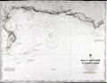 | Details | British Admiralty Hydrographical Office | 1873 |
| Antique Chart of the Bill of Portland to St Albans Head, England |
|
British Admiralty Hydrographical Office |
|
| 1873 |
| LOC:0 |
| $265.00 | British-Admiralty-Hydrographical-Office | Antique-Chart-of-the-Bill-of-Portland-to-St-Albans-Head--England | Old antique linen-backed sea chart of the Portland Bill, a promontory on the Isle of Portland, in southern Dorset, England extending eastward to the rocky headland of St. Albans Head. Two lighthouses are shown highlighted in yellow, an upper and a lower lighthouse. Key features identified by name on the chart include Portland Ledge, the Shambles, Weymouth, Melcombe Regis, White Nore, East and West Lulworth, Kimeridge, St. Alban's Head, and Endcombe House.
<br></br>
The surrounding coast of Portland, namely Portland Bill and Chesil Beach, have been notorious for the many vessels that became shipwrecked in the area over the centuries. The dangerous coastline, which features a stony shingle beach, shallow reefs and the Shambles sandbank, was proven more hazardous due to the strong tidal rapid known as the Portland Race. The Portland race, with short choppy waves and eddies, is caused by the constriction of the tidal flow between the Bill and the Shambles.
<br></br>
Published by the Admiralty March 5, 1873 under the Superintendence of Rear Admiral G.H. Richards, Hydrographer. Contains a pasted label for the seller, James Wyld, Geographer to the Queen.
<br></br>
See also a
<a href="http://www.rarecharts.com/ShowDetail/Creator/British-Admiralty-Hydrographical-Office/Title/Antique-Chart-of-the-Dorset-Coast-with-Weymouth-and-Portland--England/863 " target="_blank">similar large-scale chart of Weymouth and Portland.</a> |
| 863 | 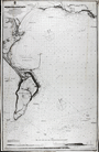 | Details | British Admiralty Hydrographical Office | 1873 |
| Antique Chart of the Dorset Coast with Weymouth and Portland, England |
|
British Admiralty Hydrographical Office |
|
| 1873 |
| LOC:0 |
| $285.00 | British-Admiralty-Hydrographical-Office | Antique-Chart-of-the-Dorset-Coast-with-Weymouth-and-Portland--England | Large-scale detailed antique linen-backed sea chart of Weymouth, the West Bay, the Shambles, Portland Harbour, and Portland Bill, a promontory on the Isle of Portland, in southern Dorset, England. Two lighthouses are shown highlighted in yellow, an high light and a lower lighthouse. Three attractive inset elevation views at bottom include: Anvil Point, Wyke Regis Church, and the Small Chalk Pit.
<br></br>
Portland Bill and the nearby area have been notorious for the many vessels that became shipwrecked in the area over the centuries. The dangerous coastline, which features a stony shingle beach, shallow reefs and the Shambles sandbank, was proven more hazardous due to the strong tidal rapid known as the Portland Race. The Portland race, with short choppy waves and eddies, is caused by the constriction of the tidal flow between the Bill and the Shambles.
<br></br>
Key features identified by name on the chart include Portland Ledge, Chesilton, a merchant ships anchorage, the man of war anchorage, the Shambles, Weymouth, Melcombe Regis, Jordan Hill, Ringsted Ledge, and Holworth Cliff.
<br></br>
Published by the Admiralty May 9, 1855 with corrections to 1873. Contains a pasted label for the seller, J. Wyld, Geographer to the Queen. Scale 1/18,200.
<br></br>
See also a similar small-scale chart covering a
<a href="http://www.rarecharts.com/ShowDetail/Creator/British-Admiralty-Hydrographical-Office/Title/Antique-Chart-of-the-Bill-of-Portland-to-St-Albans-Head--England/862 " target="_blank">wider area of the Dorset coast to St. Alban's Head.</a> |
| 860 | 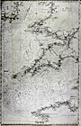 | Details | British Admiralty Hydrographical Office | 1874 |
| Antique linen-backed chart of the English Channel and Bristol Channel |
|
British Admiralty Hydrographical Office |
|
| 1874 |
| LOC:0 |
| $350.00 | British-Admiralty-Hydrographical-Office | Antique-linen-backed-chart-of-the-English-Channel-and-Bristol-Channel | Old antique nautical chart of the English Channel first published by the British Admiralty on July 1, 1859. This edition bears cumulative corrections to 1874. Coverage extends from Finisterre, France and Ushant ( "Ile de Ouessant" ) past the English county of Cornwall, past Wales, to the southeast coast of Ireland including Wexford and Waterford. Key features include Brest, France, the island of Guernsey, Cornwall, The Scilly Isles, the Bristol Channel, Saint George's Channel, and Cardigan Bay.
<br></br>
Original seller's attribution to J.D. Potter is pasted over with an addendum: "Sold by J. Wyld, Geographer to Her Majesty. 457 Strand." With the oval logo of the Hydrographical Service. Chart # 2675b. |
| 3653 | 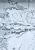 | Details | British Admiralty Hydrographical Office | 1875 |
| Scarce British chart of East Falkland Island and Stanley Harbor |
|
British Admiralty Hydrographical Office |
|
| 1875 |
| LOC:51 |
| $3,200.00 | British-Admiralty-Hydrographical-Office | Scarce-British-chart-of-East-Falkland-Island-and-Stanley-Harbor | Scarce, perhaps very rare, British hydrographic chart of the Stanley Harbor, Port William, and Port Harriett in the Falkland Islands. The chart is based on observations taken during the surveys of Captain Robert Fitzroy (1805 -1865) during the second voyage of the HMS Beagle. Includes an elevation view of the Cape Pembroke lighthouse.
<br></br>
A search of OCLC/WorldCat revealed that no libraries were found to hold the chart and no examples are online for sale. One instance of a sale of this chart is recorded in the Antique Map Price Record, in 2006.
<br></br>
Originally published by an act of Parliament in 1847. This chart was printed with corrections and additions in 1875 from London. With the seller's oval blue ink stamp of Phillip, Son & Nephew, Agents for the Admiralty Charts, 49 South Castle Street, Liverpool. Last correction 1875.
<br></br>
Robert Fitzroy studied at the Royal Naval College. His first command was the famed sloop HMS Beagle. During the Beagle's second voyage (Dec. 1831 - Oct. 1836) Fitzroy surveyed the coasts of Patagonia, Tierra del Fuego and the Straits of Magellan, accompanied by the naturalist Charles Darwin, whose later publications were largely based on discoveries and observations made during this voyage. Darwin and Fitzroy shared quarters aboard the Beagle and their discussions aboard ship are believed to have greatly influenced Darwin.
<br></br>
The main purpose of the expedition was to conduct a hydrographic survey of the coasts of the southern part of South America. The voyages of the Beagle established FitzRoy as an excellent navigator, a sound surveyor and a man of science. Suffering from depression, Fitzroy took his own life with a straight razor in 1865. Today a settlement on East Falkland is named in honor of Robert Fitzroy.
<br></br>
Chart no. 1774. |
| 3652 | 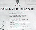 | Details | British Admiralty Hydrographical Office | 1880 |
| Scarce British chart of the Falklands from Fitzroy, Robinson, and Sullivan |
|
British Admiralty Hydrographical Office |
|
| 1880 |
| LOC:51 |
| $4,000.00 | British-Admiralty-Hydrographical-Office | Scarce-British-chart-of-the-Falklands-from-Fitzroy--Robinson--and-Sullivan | Scarce, perhaps very rare, British hydrographic chart of the Falkland Islands based on observations taken during the surveys of Captain Robert Fitzroy (1805 -1865) and others. Includes ten coastal elevation views of the Falklands as seen from sea. Published by an act of Parliament in 1841 this chart was printed with corrections and additions in 1880. With the seller's oval blue ink stamp of Phillip, Son & Nephew, Agents for the Admiralty Charts, 49 South Castle Street, Liverpool.
<br></br>
No holdings of this chart are found in OCLC, no examples are online for sale. No records in AMPR.
<br></br>
Robert Fitzroy studied at the Royal Naval College. His first command was the famed sloop HMS Beagle. During the Beagle's second voyage (Dec. 1831 - Oct. 1836) Fitzroy surveyed the coasts of Patagonia, Tierra del Fuego and the Straits of Magellan, accompanied by the naturalist Charles Darwin, whose later publications were largely based on discoveries and observations made during this voyage. Darwin and Fitzroy shared quarters aboard the Beagle and their discussions aboard ship are believed to have greatly influenced Darwin.
<br></br>
The main purpose of the expedition was to conduct a hydrographic survey of the coasts of the southern part of South America. The voyages of the Beagle established FitzRoy as an excellent navigator, a sound surveyor and a man of science. Suffering from depression, Fitzroy took his own life with a straight razor in 1865. Today a settlement on East Falkland is named in honor of Robert Fitzroy.
<br></br>
Chart no. 1354. |
| 1276 | 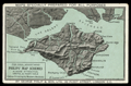 | Details | Philip. George | 1880 |
| Antique trade card for publishers George Philip and Son, London |
|
Philip. George |
|
| 1880 |
| LOC:0 |
| $165.00 | Philip--George | Antique-trade-card-for-publishers-George-Philip-and-Son--London | Large 19th-century <b>trade card</b> ca. 1880 for <b>George Philip & Son Ltd.</b>, London, England, one of the oldest publishers in the United Kingdom. This trade card promotes Philips' map design capability and printing technology: "MAPS SPECIALLY PREPARED FOR ALL PURPOSES" and "For Ideal Advertising. Philips' Map Schemes always attractive, useful, and profitable. Colour printing by modern methods."
<br></br>
The two-color card image shows the Isle of Wight with the Solent and Spithead.
<br></br>
George Philip and Son, a British publishing house, one of the oldest in the United Kingdom. The company, specializing in maps and atlases, was founded in 1834. In 1852 a London house was opened at 32 Fleet Street, to promote sales of the firm's geographical and educational publications at home and abroad. The firm grew rapidly, helped by new technology — notably power-driven lithographic presses and the machine-colouring of maps. <a href="http://www.gracesguide.co.uk/George_Philip_and_Son" target="_blank">(Online)</a> |
| 1259 | 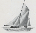 | Details | Norie and Wilson | 1890 |
| Sailing Vessels How to Distinguish Their Different Rigs |
|
Norie and Wilson |
|
| 1890 |
| LOC:0 |
| $0.00 | Norie-and-Wilson | Sailing-Vessels-How-to-Distinguish-Their-Different-Rigs | SOLD<br></br>
Small antique illustrated nautical booklet that defines and visually presents several types of 19th-century sailing vessels including: ship, barque, barquantine, brig, brigantine, schooners (top-sail, main-top-sail, fore and aft and three-masted), cutter, sloop, barge, lugger and others. At the end of the 19th century Norie and Wilson operated a nautical training adademy from 156 Minories with a focus toward training aspiring yachtsmen. This book would have likely been used by students of the academy.
<br></br>
With detailed plans of the standing rigging, running rigging, and square sails and driver for a merchant ship that name and relate each item to a drawing of the vessel. With additional illustrations showing the ropes, spars, and sails of both a yawl and a schooner.
<br></br>
Examples include:
<div class="indenttextblock">
<ul style="list-style-type: circle;">
<li>Sloop- A <b>SLOOP</b> has one mast and fore-and-aft sails like the Cutter but has a fixed standing bowsprit and jibboom, inclining upwards: her jib set upon a standing stay with hanks and carries a top-sail, sometimes a flying top-gallant sail and gaff-top-sail. </li>
<li>Barque- A <b>BARQUE</b> , or Bark is a vessel with three masts square rigged at the fore and main masts like a ship, but differs from a ship in having no top at her mizzen mast and carrying only fore-and-aft sails (A spanker and gaff-top-sail) on that mast.</li>
<li>Lugger- A <b>LUGGER</b> has either two or three masts with square-cut sails set fore and aft, called lug sails- some carry top-sails. These boats are called by the French Chasse-marees.</li>
</ul>
</div>
Published from London, England by Norie and Wilson at the Navigation Warehouse and Naval Academy, 156 Minories E. The firm of Norie and Wilson operated from 156 Minories after 1878 when they moved from their previous site they and precursor firms had occupied since 1763 at 157 Leadenhall. |
| 759 | 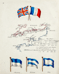 | Details | Anonymous | 1890 |
| Manuscript page with flags and a chart of British Channel |
|
Anonymous |
|
| 1890 |
| LOC:7 |
| $450.00 | Anonymous | Manuscript-page-with-flags-and-a-chart-of-British-Channel | A small manuscript chart of the English Channel. Decorated at top with the crossed flags of England and France this hand-drawn and hand-colored chart of the British Channel could have been created in the latter half of the 19th century to early 20th century by a British naval student or maritime officer candidate or quite possibly a member of the Sea Cadets Corps or its predecessor, the Naval Lads' Brigade. A legend in English describes features that would be found on a nautical chart of the period such as buoys, rocks, and bearings, but oddly the manuscript map does not contain any of those components with one exception, the Eddystone lighthouse southwest of Plymouth sound.
<br></br>
The most interesting aspect of the chart is the dotted line suggesting the route of a voyage between ports in England and France including Plymouth, Dartmouth, Torquay, Weymouth, Southampton, Sheerness, Cherbourg, and Guernsey
<br></br>
At bottom are drawn three signal flags including the Blue Peter, which was often used when preparing to leave port, or as the caption suggests, when requesting a pilot. Of the other two flags, the center flag is confirmed as a French registration flag that indicates that the vessel was registered to the Cherbourg arondissement sector between Dunkirk and Honfleur. According to Sache:
<div class="indenttextblock">
"French merchant ships had to hoist at foremast a specific flag indicating in which arrondissement they were registered. The French coasts were divided in five metropolitan maritime arrondissements, each of them being divided in two sectors, and in two colonial sectors. The arrondissement flags were established by Royal Regulation of 3 December 1817, signed by Louis XVIII. They were confirmed in the 1852 Imperial Regulations on naval flags signed by Napoléon III and by Decree on 20 March 1868. " </div>
Source: Sache, Ivan. France: Registration flags for merchant ships (1817-1929). Link: flagspot.net/flags/fr~arro.html#che |
| 5183 |  | Details | Herbinet, B. | 1895 |
| Manuscript map Iles Britanniques with submarine |
|
Herbinet, B. |
|
| 1895 |
| LOC:200 |
| $250.00 | Herbinet--B- | Manuscript-map-Iles-Britanniques-with-submarine | Interesting manuscript French map "Iles Britanniques" with vignettes illustrating the prowess of those isles at a time when Britain ruled the waves. Shows major roads or railways.
<br></br>
Inset vignettes include:
<div class="indenttextblocksingle">
<ul style="list-style-type: circle;">
<li>A suspension bridge</li>
<li>A coal mine</li>
<li><b>An early submarine: "la Gombe. Bateau sous marine"</b></li>
<li>A transitional three-masted warship with supplemental steam power </li>
<li>A geyser</li>
</ul>
</div>
Beautifully signed in manuscript "B. Herbinet Avril 1895" |
| 1166 |  | Details | Lane and Neeve | 1895 |
| Flags of All Nations |
|
Lane and Neeve |
|
| 1895 |
| LOC:0 |
| $0.00 | Lane-and-Neeve | Flags-of-All-Nations | SOLD
<br></br>
Scarce and very colorful 19th century lithographed brochure/print of world flags. This scarce Victorian survivor presents numerous national flags, national merchant flags, naval ensigns and pendants. Prominently features the Royal Standard of Great Britain, the American Ensign and the American Jack. 44 stars on the American flags indicates the a date for the print between 1891 and 1896 when the U.S. added a star for the admission of Utah to the Union. When opened this attractive antique measures 15" x 22".
<br></br>
This seldom found brochure, "Flags of All Nations", is from the firm of Lane and Neeve at 4 Minories, London, East. That firm describes its commercial activities succinctly as Yacht Sail Makers, Yacht Flag Makers, Sail Makers, and Ship Chandlers. Lane and Neeve was located at 4 Minories, near the Tower of London and the Thames river, in an area with numerous other maritime-related business. The flag maker advertised their offerings on the back cover" "Flags Made to Order; House Flags, Name Burgees, Banners and Silk Flags". Also advertised is the sail loft at Britannia Works, East Ferry Road, London.
<br></br>
Folds to a compact 5" x 9". Printed by McLagan and Cumming. Lithographers, Edinburgh. |
| 5277 | 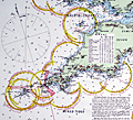 | Details | Stanford, Edward | 1900 |
| Superb late 19th-century nautical chart of the English Channel |
|
Stanford, Edward |
|
| 1900 |
| LOC:1409 |
| $2,575.00 | Stanford--Edward | Superb-late-19th-century-nautical-chart-of-the-English-Channel | A visually captivating and informative original antique 19th-century nautical reference chart of the English Channel with visible extent of lighthouses shown graphically. Uncommon. The few similar items that come to mind are Hardinge's 1874 "British Lighthouse Chart of General Coast Lights", and "A Chart Exhibiting the Light Houses and Light Vessels of the Coasts of Great Britain and Ireland" issued by the Corporation of the Trinity House, 1863.
<br><br>
This antique original, rolled, linen-backed chart, based on data from Lieutenant H.C. Lockyer in 1899, was published by Edward Stanford from Stanford's Geographical Establishment in London on March 1, 1900. Stanford's, established in 1853, remains in business today, now at 7 Mercer Walk in Covent Garden.
<br></br>
Coverage includes relevant portions of the coast of Ireland, Wales, England, and France, with Cornwall near chart center.
<br><br>
Scarce, especially in fine condition as this example. Only one institutional holding in WorldCat.
<br></br>
Contains drawings of the uniform system of buoyage: starboard-hand buoys, port-hand buoys, middle ground buoys; pillar, spar, and gas buoys; and wreck-marking vessels. Of great visual interest are the dozens of lighthouses identified on the chart with the range, frequency, duration, and color of each light provided for navigators. The chart is filled with tide tables, general information, soundings and distances and sailing directions for numerous ports. Topographical detail useful to navigators is shown for coastal locations and for those inland locations where the height of a feature warranted inclusion, e.g. Brecknock Mountain, Wales at 2862 ft. elevation.
<br></br> |
| 715 | 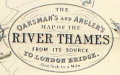 | Details | Stanford, Edward | 1901 |
| Oarsman's and Anglers Map of the River Thames from its Source to London Bridge |
|
Stanford, Edward |
|
| 1901 |
| LOC:0 |
| $425.00 | Stanford--Edward | Oarsman-s-and-Anglers-Map-of-the-River-Thames-from-its-Source-to-London-Bridge | <BR></br><div class="indenttextblock">"The Editors… have endeavored to lay down the course over which a punt should be shoved. <i>They wish it to be distinctly understood that they do not claim to have found the best shoving in all cases</i>, but they have tried to describe the bottom of the river as they know it, perhaps not as intelligibly as they would have wished, owing to the exigencies of space and the subsequent condensation of language. "</div>
<br>Thus begins the introduction to this very interesting and quirky map of the Thames River, published in 1901 and oriented to the fishermen and boaters of the area. Filled with information about the Thames, not only locks, water depth, bridges and other navigational information, but also, inns, hotels, and boatyards.
<br></br>
A reader does not have to go too far perusing the notes on this chart to need a good nautical reference book, as some of the practices of that era are now outdated or not applicable in other countries. For example this note on Hart's or Eaton's Weir: <div class="indenttextblock">"The only weir on the Thames which has to be 'shot'. There is usually someone at the neighboring inn who will lend a hand in drawing the paddles and rymers." </div> Hmmm. Turns out that the term "paddles and rymers" refers to a method of lock construction for "flash locks" based on a single gate. The method of construction dates back to the medieval period. Paddle and rymer weirs are operated by placing large wooden posts – the rymers – into the bottom of the river. To control the water flow, paddles of different heights were placed against the rymers. When the paddles were removed water would pour through the opening and boaters would "shoot" the opening. This method of construction is now considered dangerous and most paddle and rymer weirs have been updated.
<br></br> Published by Edward Stanton, 12, 13, & 14, Long Acre, W.C. |
| 6503 |  | Details | Peninsular and Oriental Shipping Co. | 1910 |
| P and O Pleasure Mediterranean Cruises Handbill for 1910 |
|
Peninsular and Oriental Shipping Co. |
|
| 1910 |
| LOC:78 |
| $120.00 | Peninsular-and-Oriental-Shipping-Co- | P-and-O-Pleasure-Mediterranean-Cruises-Handbill-for-1910 | Small strikingly vivid, original lithographed handbill for Mediterranean cruises with the ships of London-based Peninsular and Oriental (P&O) Steam Navigation Company in 1910. Twin inset schedules with details and dates of cruises aboard the Mantua and the Vectis two of P&O's eight new steamers of the "M" class. Text on verso.
<br><br>
A very attractive and colorful chromolithograph related to Mediterranean tourism at the beginning of the twentieth century. |
| 995 | 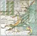 | Details | Stanford, Edward | 1920 |
| Stanford's Colored Chart of the Thames Estuary |
|
Stanford, Edward |
|
| 1920 |
| LOC:0 |
| $145.00 | Stanford--Edward | Stanford-s-Colored-Chart-of-the-Thames-Estuary | 2 coloured lithographic charts mounted on linen and folding into the same original cloth covers with paper label. With a tide table and 12 small inset maps showing tidal flows in knots over a 12 hour period based on high-water at Dover.
<br></br>
Two folding charts, the largest mounted on linen and both folding into the same original cloth covers with paper label.
<br/>
--Estuary Chart "Stanford's Chart of the Thames Estuary Prepared Under the Supervision of Captain O.M. Watts, A.I.N.A.". 28" x 27".
<br/>
--River Thames. "The River Thames from London to Gravesend". 20" x 6"
<br></br>
Original blue cloth boards with mounted printed publisher's plate to front cover. Published by Edward Stanton, 12, 13, & 14, Long Acre, W.C.2 London and Whitehall S.W.1 |
| 5265 |  | Details | Whitfield Colliery | 1928 |
| Three MS plans mining accidents Whitfield Colliery, Staffordshire, England |
|
Whitfield Colliery |
|
| 1928 |
| LOC:7 |
| $265.00 | Whitfield-Colliery | Three-MS-plans-mining-accidents-Whitfield-Colliery--Staffordshire--England | Lot containing three manuscript plans related to mining accidents at the Chatterley Whitfield colliery (coal mine) in Stoke-on-Trent, Staffordshire, England. The three accidents took place over a period of eight years, attesting to the danger of coal mining.
<div class="indenttextblocksingle">
<ul style="list-style-type: circle;">
<li>Plan shewing scene of accident to Charles Stubbs on Newtons No. 3 north conveyor face institute pit 29th Oct. 1935. [MS plan on paper at a scale of 1/4" = 1 foot]</li>
<li>Plan showing scene of accident to Joseph Howell on No. 5 Bowling Alley Level, Holly Lane dip in the middle pit. 8/1/37 [MS plan of tracing cloth. Scale 1/4" = one foot]</li>
<li>Plan shewing scene of accident to Richard Harper in the No. 3 south ten feet, hard mine dip, middle pit on 27-3-29. [MS plan of tracing cloth. Scale 1/4" = one foot] </li>
</ul>
</div>
The Chatterley Whitfield colliery was the largest mine working the North Staffordshire coalfield and was the first colliery in the UK to produce 1,000,000 tons of saleable coal in a year (1938). In 2019, the colliery was named on the Victorian Society's list of the top ten most endangered buildings in England and Wales. |
| 4974 |  | Details | Camm, Frederick James | 1933 |
| The Fury Four Circuit Map |
|
Camm, Frederick James |
|
| 1933 |
| LOC:10 |
| $125.00 | Camm--Frederick-James | The-Fury-Four-Circuit-Map | Circuit map of the Fury Four radio introduced in 1933. The circuit was characterized by two high-frequency stages. Not to be confused with the 1954 revised circuit for the Fury Four. Printed in blue in the style of a cyanotype, or blueprint diagram. Dated within as February 11, 1933. Drawn by F.J. Camm and published by George Newnes Ltd. as a free supplement to the magazine "Practical Wireless.
<br></br>
Frederick James Camm (1895 – 1959) was an English technical author and magazine editor. He founded several radio and electronics titles, including Practical Wireless devoted to radio and electronics. In 2017 Practical Wireless was sold to Warners Group Publications, a Lincolnshire-based publishing company. |
| 6613 |  | Details | British Information Services | 1942 |
| Pictorial WWII era propaganda map Great Britain Natural and Industrial Resources |
|
British Information Services |
|
| 1942 |
| LOC:400 |
| $2,500.00 | British-Information-Services | Pictorial-WWII-era-propaganda-map-Great-Britain-Natural-and-Industrial-Resources | Large, lithographed poster-sized map: "Great Britain Her Natural & Industrial Resources" published circa 1942, during WWII, by British Information Services. On the verso a printed statement: "Printed in Great Britain." Scarce on the market and quite nicely executed.
<br><br>
At bottom right the attribution reads: "Distributed by British Information Services, an agency of the British Government, 30 Rockefeller Plaza, New York City." British Information Services was formed in 1941 as an office of the British Government with the goal to promote Britain's interests in the United States. Prior to December 1941 the United States had not formally entered into the war in Europe and this map poster was part of the propaganda Britain employed to sway U.S. opinion to its side. |
| 5223 |  | Details | National Fire Service Benevolent Fund | 1944 |
| Bird's-eye View of the V1 Bomb an Early Cruise Missile |
|
National Fire Service Benevolent Fund |
|
| 1944 |
| LOC:13 |
| $110.00 | National-Fire-Service-Benevolent-Fund | Bird-s-eye-View-of-the-V1-Bomb-an-Early-Cruise-Missile | Single-page folding booklet with a schematic diagram of the German V-1 bomb flying above a bird's eye view of the British countryside. The V-1 was a German weapon, an early and crude cruise missile, designed to strike terror into the British population. During World War II Germany used the V-1 in the thousands against south-east England from launch sites along the French and Dutch coasts.
<br></br>
Reproduced from the London Illustrated News with proceeds devoted to the National Fire Service Benevolent Fund.
<br></br>
With text, cutaway drawings, and inset schematic diagrams explaining of the German impulse engine (an early jet engine) and the mechanism used to control the missile's flight path. Verso with text and title page.
<br></br>
Price when issued: sixpence. Drawn by G.H. Tavis. 1944. Printed by Temple Fortune Press. Printers. London. |
| 5085 |  | Details | Anonymous | 1970 |
| Manuscript copy of the map City of Bath after Joseph Gilmore |
|
Anonymous |
|
| 1970 |
| LOC:200 |
| $450.00 | Anonymous | Manuscript-copy-of-the-map-City-of-Bath-after-Joseph-Gilmore | Manuscript pen and ink (hand drawn) map of the City of Bath, England after an earlier map by Joseph Gilmore in 1731. On heavy paper. Likely mid-20th century. Differs from Gilmore's original map of Bath in that fewer buildings are shown on the border of the map.
<br></br>
Gilmore's original elaborate map of the city of Bath shows Bath still largely contained within its medieval walls. The map indicates the growing popularity of Bath as a destination for visitors in the early 18th century. Around the border of Gilmore's map are views of 36 lodging houses or other public buildings. The map was reissued 6 times between 1694 and 1731. |
| 7979 |  | Details | International Map Services Ltd. | 1975 |
| Grand Cayman Island Underwater Dive Chart |
|
International Map Services Ltd. |
|
| 1975 |
| LOC:86 |
| $175.00 | International-Map-Services-Ltd- | Grand-Cayman-Island-Underwater-Dive-Chart | Unrecorded fine pirate-themed chart of underwater dive sites in the Cayman Island ca. 1975.
Grand Cayman is the largest of the three Cayman Islands, which are a British Overseas Territory in the western Caribbean Sea. The map is specifically an "Underwater Dive Chart," highlighting various dive sites, dive shops and marine life around the island.
<br><br>
Some of the many dive sites noted include: New Tarpon Alley, Hepps Pipeline, Pinnacle Rock, Bonnie's Arch, Oro Verde Wreck, Balboa Wreck, Japanese Gardens, and East End Reefs.
<br><br>
Also noted is Bob Soto's diving shop. Bob Soto (1926–2015), known as the “Father of Diving” in the Cayman Islands, died at age 88, prompting dive flags to fly at half-mast across the islands. He founded recreational scuba diving in the Cayman Islands when he opened the first dive shop on George Town’s waterfront in 1957, starting with one wooden boat, several tanks, and a small staff he personally trained. Soto’s pioneering efforts created the foundation of Cayman’s world-renowned dive industry, mentoring many of today’s dive leaders.
<br><br>
Copyright International Map Services Ltd. P.O. Box 2187. Cayman Islands, B.W.I. "International Map Services Ltd." was a small company based in George Town, Grand Cayman, Cayman Islands, and was involved in the map publishing industry. |