| | Thumbnail | | Creator | Date | Title / Author / Date / Location | Price | | | Description |
| 8077 | 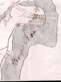 | Details | Unknown Union Source | 1862 |
| The Port Royal Experiment Manuscript Civil War Map Beaufort SC |
|
Unknown Union Source |
|
| 1862 |
| LOC:89 |
| $4,500.00 | Unknown-Union-Source | The-Port-Royal-Experiment-Manuscript-Civil-War-Map-Beaufort-SC | This Civil War–era manuscript map of Beaufort, South Carolina and its surrounding waterways documents the region at the birth of Reconstruction ca. 1862. The map is perhaps the earliest record during what became known as the <b>Port Royal Experiment</b>, when Union occupation, emancipation, and continued military conflict unfolded at the same time. The map shows inland roads, ferries, and navigable rivers, identifies numerous named plantations, and records Union and Confederate picket positions, defensive rifle pits near Beaufort, the battlefield at Port Royal Ferry, and notations of Confederate shelling. It reflects a landscape under Union control but still actively contested.<br><br>The most striking feature of the map is the large number of plantations recorded and the size of the text used to describe plantation ownership vs the military detail. After Union forces captured the Beaufort area in late 1861, most plantation owners fled, leaving more than ten thousand emancipated Gullah people on intact estates without pay, supplies, or legal protection. Beginning in 1862, Northerners arrived to address immediate problems: preventing starvation, organizing paid work, starting schools, and safeguarding newly won freedom for the formerly enslaved. For teachers, missionaries, Treasury agents, and Army officers, a map like this was a working tool. It showed where people lived, where food and cotton were stored, how plantations were connected by roads and waterways, and which routes could be traveled with relative safety. |
| 6730 | 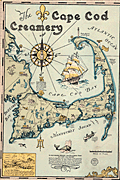 | Details | Gaffney, Walter M. | 1933 |
| Pictorial advertising map for the Cape Cod Creamery |
|
Gaffney, Walter M. |
|
| 1933 |
| LOC:13 |
| $550.00 | Gaffney--Walter-M- | Pictorial-advertising-map-for-the-Cape-Cod-Creamery | Historical pictorial map for Cape Cod Creamery ca. 1933 by Walter M. Gaffney. An unrecorded advertising piece for Cape Cod Creamery, associated with Noble's milk. On heavy card stock. Maps numerous historical and geographic locations including Pilgrim Monument, the Highland Light, Pleasant Bay, the Sandy Neck Light, the Cape Cod Canal. Scattered in each corner is a logo for Noble's milk, the map shows several delivery trucks labeled "Noble's that's good milk", and the large compass rose with a bottle of milk arranged at the center. Small piece of contiguous card stock apparently fashioned into a print hanger suggests the piece may have been trimmed into this shape by a previous owner.
<br><br>
Includes Buzzards Bay, Duxbury Bay, Provincetown Harbor, Wellfleet Harbor, Barnstable Harbor, Pleasant Bay, and a portion of Nantucket Sound.
<br><br>
<div class="indenttextblocksingle">
"Wellfleet or Whalefleet as it was originally called undoubtedly surpassed other towns. In 1843 a whale was captured near the end of the Cape and estimated to contain 200 barrels of oil and 2000 pounds of bone. Only 125 barrels of oil and 300 lbs. of bone were saved but with this waste it netted $10,000."
</div>
<br><br>
Gaffney is also credited with a larger pictorial map of Cap Cod 1932, in a different style, less historically oriented. |
| 6533 | 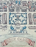 | Details | Fell, April P. | 1976 |
| Plan New Orleans Vieux Carre by April Fell |
|
Fell, April P. |
|
| 1976 |
| LOC:68 |
| $375.00 | Fell--April-P- | Plan-New-Orleans-Vieux-Carre-by-April-Fell | Scarce plan of the Vieux Carre or French Quarter in New Orleans, Louisiana by April P. Fell in 1976. Shows the buildings and street layout of the French Quarter as they existed in 1976. The limits of the Vieux Carre are the Mississippi River, Canal Street, Rampart Street, and Esplanade Avenue.
<br><br>
Todd and April Fell lived in New Orleans beginning in the 70s. They created a travel book called 'The Vignette' that was published until 1987.
<br><br>
Published by The Vignette 240 Rue Chartres. Copyright 1976. |
| 6503 | 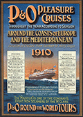 | Details | Peninsular and Oriental Shipping Co. | 1910 |
| P and O Pleasure Mediterranean Cruises Handbill for 1910 |
|
Peninsular and Oriental Shipping Co. |
|
| 1910 |
| LOC:78 |
| $120.00 | Peninsular-and-Oriental-Shipping-Co- | P-and-O-Pleasure-Mediterranean-Cruises-Handbill-for-1910 | Small strikingly vivid, original lithographed handbill for Mediterranean cruises with the ships of London-based Peninsular and Oriental (P&O) Steam Navigation Company in 1910. Twin inset schedules with details and dates of cruises aboard the Mantua and the Vectis two of P&O's eight new steamers of the "M" class. Text on verso.
<br><br>
A very attractive and colorful chromolithograph related to Mediterranean tourism at the beginning of the twentieth century. |
| 6500 | 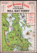 | Details | Page, Peter Hugh | 1936 |
| Rare pictorial map of Victoria, British Columbia with Ferry Routes |
|
Page, Peter Hugh |
|
| 1936 |
| LOC:78 |
| $350.00 | Page--Peter-Hugh | Rare-pictorial-map-of-Victoria--British-Columbia-with-Ferry-Routes | Rare pictorial auto map of Victoria, Vancouver Island, British Columbia, Canada featuring the Mill Bay Ferry route as an element of the Scenic Circle auto route. The map features numerous small cartoonish drawings of local activities including golfing, hunting, fishing, gardening, and horse racing. No holdings of this rare pictorial auto route map are found anywhere else online, nor any record of sales. Dated within to 1936.
<br><br>
Locations noted on the map include Telegraph Beach, Victoria Golf Club, James Island, Sidney, Sidney Island, Esquimalt Harbor, and Cordova Bay.
<br><br>
On card stock, this unusual piece of cartographic ephemera includes the original string hanger still attached through two punched holes.
<br><br>
Recto with departure times for the Mill Bay Ferry from both Malahat and from Brentwood. Verso with a photo of the ferry - M.S. Cascade, an inset smaller-scale sketch map of the Victoria surrounding area, a mileage table, and text on points of interest and suggestions for the Scenic Circle drive.
<div class="indenttextblocksingle">
"Ferry Trip across the placid waters of Saanich Arm, Sport Fishing preserve, where salmon up to 53-lbs. are taken and over fifty species of fish are found. From the Ferry can be seen Senanus Island, an ancient Indian burial ground, Bamberton Cement Works, Brentwood Cottage".
<br>and<br>
"A glance at the Map on the other side will convince you of the ease and simplicity of this Route. You can save MONEY, TIME and reduce your mileage from 83 to 45 by using this convenient connecting link [ferry] between Mr. BUTCHARTS GARNENS and the Famous MALAHAT DRIVE…"
</div> |
| 5433 | 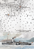 | Details | Anonymous | 1950 |
| Map of Rothesay Sound with watercolor side-wheel steamer. |
|
Anonymous |
|
| 1950 |
| LOC:78 |
| $160.00 | Anonymous | Map-of-Rothesay-Sound-with-watercolor-side-wheel-steamer- | Attractive, offset lithographed chart of Rothesay Sound and the Firth of Clyde, Scotland decorated with a small manuscript watercolor of a side-wheel steamboat. The chart is undated but probably 20th century after an earlier chart. Aids to navigation are highlighted in red and yellow.
<br></br>
The steamboat is unnamed but probably the <strong>Duchess of Fife</strong>, built and launched by Fairfield Shipbuilding and Engineering Company in May 1903. The Duchess of Fife was owned by the Caledonian Steam Packet Company and except for use during WWI and WWII, spent her career serving passenger routes in the Firth of Clyde.
<br></br>
Anonymous but initials "E.S." at bottom right corner. |
| 5371 | 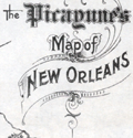 | Details | Daily Picayune | 1901 |
| The Picayune's Map of New Orleans |
|
Daily Picayune |
|
| 1901 |
| LOC:90 |
| $400.00 | Daily-Picayune | The-Picayune-s-Map-of-New-Orleans | Scarce lithographed map of New Orleans, Louisiana published by The Picayune [1] newspaper in 1901. Shows both the West End Railroad and the Ponchartrain Railroad, both now long gone.
<br></br>
The Mississippi River is shown devoid of bridges but with <b>nine ferry crossings</b>. The first bridge across the Mississippi in Louisiana was not built until 1935. Several paddlewheel steamboats are shown underway in the river
<br></br>
The Picayune newspaper was started in 1837 in New Orleans, Louisiana. In 1914 The Picayune merged with the Times-Democrat to form the Times-Picayune.
<br></br>
[1] The Picayune was named after a Spanish coin used in Florida and Louisiana worth about six and one-half cents in the 1850s. |
| 5350 | 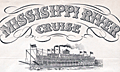 | Details | Speck, Rose M. | 1934 |
| Mississippi River paddleboat cruise to New Orleans broadside |
|
Speck, Rose M. |
|
| 1934 |
| LOC:9 |
| $625.00 | Speck--Rose-M- | Mississippi-River-paddleboat-cruise-to-New-Orleans-broadside | Rare original 1934 broadside for a two week Mississippi River cruise aboard the paddleboat Cape Girardeau. The event, limited to 100 passengers, was planned to depart New York on March 31, 1934 and was sponsored by Rose M. Speck of New York City.
<br></br>
<b>"Two weeks of Adventure on the Lower Section of the Mighty Mississippi -- Aboard the picturesque steam packet "Cape Girardeau"-- Monarch of the River"</b>
<br></br>
The $139 fare included a pullman train from New York to Memphis, Tennessee complete with a recreation car. Aboard the riverboat, passengers could plan on a two-day layover in New Orleans along with onboard entertainment including:
<div class="indenttextblocksingle">
<ul style="list-style-type: circle;">
<li>"Darkey spiritual singers"</li>
<li>Square dances</li>
<li>Costume balls</li>
<li>Masquerades</li>
<li>Deck sports</li>
<li>Sun baths</li>
<li>Swimming in the Gulf of Mexico</li>
</ul>
</div> |
| 5285 | 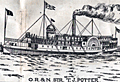 | Details | Oregon Railroad and Navigation Company | 1908 |
| Route map T. J. Potter Steamer between Portland and North Long Beach |
|
Oregon Railroad and Navigation Company |
|
| 1908 |
| LOC:10 |
| $575.00 | Oregon-Railroad-and-Navigation-Company | Route-map-T--J--Potter-Steamer-between-Portland-and-North-Long-Beach | Two rare, unrecorded advertising maps on a single sheet:<br>
1) Route of the Oregon Railroad and Navigation Company's Excursion Steamer "T. J. Potter" between Portland and North (Long) Beach. Contains an inset drawing of the Steamer T. J. Potter with a domed wheelhouse and flagpole.<br>
2) Map of the Oregon Railroad and Navigation Company Along the Columbia River, Portland to Celilo Falls. One half-page on verso.
<br></br>
Undated but ca. 1908 based on a advertisement for the excursion steamer T.J. Potter on the six-hour summer run (every day except Sunday) on the Columbia River between Portland, Oregon and North Beach, Washington promoted as "One of the Most Attractive Beach Resorts on the North Pacific Coast."
<br></br>
The T. J. Potter was a wooden side-wheel paddle steamer owned by the Oregon Railway and Navigation Company. The Potter operated on the Columbia River and Puget Sound between 1888 and 1916, and was considered for a time to be the fastest side-wheel steamer in the Northwest U. S. A. Rebuilt in 1901, the Potter then sported a dome with a flagpole instead of a flat roof. By the 1920's the Potter had been withdrawn from passenger service and was used as a quarter boat for construction crews before she was abandoned near Astoria, Washington. |
| 5138 | 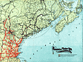 | Details | Boston and Maine Railroad | 1901 |
| Map of railway lines for the Boston and Maine Railroad |
|
Boston and Maine Railroad |
|
| 1901 |
| LOC:10 |
| $150.00 | Boston-and-Maine-Railroad | Map-of-railway-lines-for-the-Boston-and-Maine-Railroad | Official corporate map of railway and steamship lines for the Boston and Maine Railroad. Lithograph on thin paper.
<br></br>
Printed and included in the "Sixty-eighth Annual Report of the Directors of the Boston and Maine Railway to the Stockholders for the Year Ended June 30, 1901." Printed at Boston, Massachusetts in 1901 by Rand Avery Supply Company.
<br></br>
Red lines designate Boston & Maine lines and leased lines operated by the railroad. Purple lines show lines controlled by the Boston and Maine R.R. Includes steamship routes owned and operated by the company shown offshore with black or purple dotted lines. Margins about 1/4" on all sides. |
| 4907 | 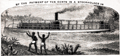 | Details | Henry Reed Steamboat Company | 1887 |
| Rare Missionary Donation Card for Congo River Steamboat |
|
Henry Reed Steamboat Company |
|
| 1887 |
| LOC:41 |
| $350.00 | Henry-Reed-Steamboat-Company | Rare-Missionary-Donation-Card-for-Congo-River-Steamboat | <br />
<div style="text-align: center;font-size:100%;">
"This certifies that <b><i>Mrs. Sara E. Buxton</i></b> <br />by the payment of ten cents <br />is a shareholder in <br /> THE HENRY REED STEAMBOAT COMPANY<br /> for the year 1887"
</div><br />
Recto with scene of a small steam-powered stern-wheel riverboat, a la the African Queen, and two native Africans watching from shore. Map on verso of the Congo Free State, the Congo River, and in the upper Congo River a dotted line shows the route of the Henry Reed. Scarce.
<br /><br />
Very rare "stock certificate" given for a donation of ten cents to support a mission steamer on the upper Congo River in Africa. The vessel "Henry Reed' worked the upper river and after 1887 another steamer joined on the lower Congo River. By 1890 the name of the mission was changed to "The Congo Steamboat Company" and funds collected paid for both vessels as well as for operating expenses. Lifetime membership could be purchased for $1.00. (Baptist Missionary Magazine. American Baptist Missionary Union. Volume 70. Boston. 1890.) |
| 4901 | 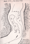 | Details | U.S. Coast and Geodetic Survey | 1865 |
| Antique Mississippi River Charts of Shoals and Sand Bars |
|
U.S. Coast and Geodetic Survey |
|
| 1865 |
| LOC:2001 |
| $500.00 | U-S--Coast-and-Geodetic-Survey | Antique-Mississippi-River-Charts-of-Shoals-and-Sand-Bars | Rare, separately published charts (23) of critical navigational areas on the Mississippi River and the Ohio River. A supplement of charts to accompany the <b>"Letter of the Secretary of the Navy communicating the report of the commission appointed under the joint resolution of Congress, approved June 30, 1864," </b> (Source: Online) <div class="indenttextblock"> "to select the most approved site for a navy yard or naval station on the Mississippi River or upon one of its tributaries and recommending a appropriation to cover the expenses of said commission." </div> The maps were not of proposed locations for the new Navy yard but of shoal or shallow areas of the Mississippi River. These shallow sand bars and narrow channels could impede the movement of vessels of vessels to the new yard:
<div class="indenttextblock">
"A series of topographical sketches of some of the difficult places of navigation on the Mississippi between Carondolet and Memphis and in the Ohio between Cairo and Cincinnati. They will have a value in furnishing means of comparison in future studies of the beds of these rivers."
</div>
<br>
Twenty-one charts (sketches) for the Mississippi River and two charts for the Ohio River including:
<div class="indenttextblocksingle">
<ul style="list-style-type: circle;">
<li>Sketch No. 1 Jefferson Barracks Bar</li>
<li>Sketch No. 3 Widow Beard's Island</li>
<li>Sketch No. 5 Penitentiary Shoal</li>
</ul>
</div>
The surveys were conducted by a Coast Survey party attached to the command of Admiral Lee, headed by F.H. Gerdes Chief of the Mississippi squadron topographical engineers.
<br></br>
The expenses of the commission included a whopping $870 to G.W. Blunt, $10 per diem from November 10, 1864 to February 4, 1865. From this expense we know that Blunt also was actively involved in the survey's that produced these maps. |
| 4798 | 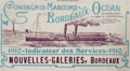 | Details | Companie Maritime Bordeaux Ocean | 1910 |
| Companie Maritime Bordeaux Ocean 1910 Route Map |
|
Companie Maritime Bordeaux Ocean |
|
| 1910 |
| LOC:88 |
| $280.00 | Companie-Maritime-Bordeaux-Ocean | Companie-Maritime-Bordeaux-Ocean-1910-Route-Map | Antique map by the French firm <b>Companie Maritime Bordeaux Ocean</b> of the Garonne River from the town of Bordeaux following the river to its mouth near Royan. A source of commercial and geographical information about the Garonne River, Gironde Department and specifically the Bordeaux wine region of France during the first decade of the 20th century. A scarce folding booklet with cover depicting a sidewheel steamboat bearing the company flag with "B.C."
<br></br>
Shows these vineyards: Chateau Margaux, Chateau Larose Trintaudon, Chateau Pichon Longueville, Chateau Latour, Chateau Moulin d'Armailhac, Château Loudenne, and Chateau Sainte Barbe. Many other landmarks are shown pictorially including the Tour de Cordouan, Port de Mortagne, Port Maubert, and Place des Quinconces. Verso incudes timetable, and many advertisements for local maritime-related firms.
<br></br>
From La Bastide and Bordeaux north to the river's confluence with the Atlantic Ocean. |
| 1240 |  | Details | Cincinnati and New Orleans Passenger Line | 1880 |
| Trade card for Steamboat Charles Morgan |
|
Cincinnati and New Orleans Passenger Line |
|
| 1880 |
| LOC:0 |
| $180.00 | Cincinnati-and-New-Orleans-Passenger-Line | Trade-card-for-Steamboat-Charles-Morgan | Very interesting and rare antique trade card for the side-wheel <b>steamboat Charles Morgan</b> of the Cincinnati and New Orleans Passenger Line. Built in 1873 and burned in Cincinnati in 1886, the Charles Morgan is well known for having Samuel Clemens a.k.a. Mark Twain as a passenger in 1882 when Clemens took a nostalgic tour to revisit places along the Mississippi River that he had visited in his previous occupation as a riverboat pilot.
<br><br/>
Front of the card contains an image resembing the steamer Charles Morgan. Verso contains the names and distances for approximately 100 of the steamboat stops along the route from Cincinnati to New Orleans, a total. distance of 1440 miles.
<br><br/>
The Charles Morgan was named for its owner, shipping tycoon Charles Morgan (1795-1878). Morgan moved to New York City at the age of fourteen and began a ship chandlery and import business which lead to investments in merchant shipping and ironworks and to management of several lines of sailing and steam packets trading with the South and the West Indies. He was also both partner and rival of Cornelius Vanderbilt in attempts to establish an isthmian transit across Nicaragua in the 1850s.
<br><br/>
Morgan City, Louisiana was named after Charles Morgan. |
| 1232 |  | Details | Colby, C. H. | 1895 |
| Antique Cabinet Card of Steamboat Okeehumkee at Silver Springs, Florida |
|
Colby, C. H. |
|
| 1895 |
| LOC:0 |
| $175.00 | Colby--C--H- | Antique-Cabinet-Card-of-Steamboat-Okeehumkee-at-Silver-Springs--Florida | Large antique cabinet card of the steamer Okeehumkee docked at the Silver Springs' Florida landing, moss-covered trees in the background. The Okeehumkee, also known as "Queen of the Ocklawaha River," was a 84' x 21'river steamboat that provided transportation along Florida rivers in the late 19th century. The Okeehumkee was equipped with a paddle wheel positioned in the lower stern part of the boat which allowed it to traverse narrow and shallow rivers.
<br></br>
The steamer Okeehumkee was built in 1873 by Hubbard Hart, founder of the Ocklawaha Navigation Company's Hart's Line, at his East Palatka Hart's Point shipyard. It was named after a Native American chief from the area of the Ocklawaha lakes. The boat was outfitted with shutters on the windows to keep tree branches out and a livestock pen at the rear of the boat, on the upper deck. The boat was altered several times throughout its service lifetime. In 1893, a second deck of cabins was added. In 1919, Hart's Line ceased operation and the Okeehumkee was moored at Hart's Point shipyard in East Palatka.
<br></br>
In 1883 Lady Duffus Hardy published a <a href="https://books.google.com/books?id=-Iw-AAAAYAAJ&printsec=frontcover&dq=inauthor:%22Lady+Duffus+Hardy%22&hl=en&sa=X&ved=0ahUKEwjJvM-_nNHTAhXQZiYKHWdED4sQ6AEIJzAA#v=onepage&q&f=false" target="_blank">vivid account</a> of her trip aboard the Okeehumkee on the Oklawaha River from Silver Springs, Florida to Palatka. Lady Hardy relates how pine logs were burned in a large cauldron at the top of the vessel to provide illumination at night. "Now the blue flame flashes up to the great tree tops, then darts downward like a fiery serpent, and up some winding water lane, and for a second, a thousand weird forms float before our eyes, and change and fade and melt into nothingness." |
| 1223 |  | Details | Anonymous | 1840 |
| Uncommon antique Map of Lake Pontchartrain |
|
Anonymous |
|
| 1840 |
| LOC:3 |
| $200.00 | Anonymous | Uncommon-antique-Map-of-Lake-Pontchartrain | Uncommon and unrecorded version of a lithographed map ca. 1840 of <b>Lake Pontchartrain</b> in Louisiana with three steamboat routes shown: to Madisonville, La., to Mandeville, La. and a mail steamboat route to Mobile, Alabama. Possibly by L. Hirt.
<br></br>
In 1834 it was reported that mail service was provided through three weekly round-trips between New Orleans and Mobile at a total annual cost of <a href="https://books.google.com/books?id=VfcaAAAAYAAJ&pg=PR1&dq=mail+steam+boat+mobile+new+orleans&source=gbs_selected_pages&cad=3#v=onepage&q=mail%20steam%20boat%20mobile%20new%20orleans&f=false" target="_blank">$40,000.</a></a>
<br></br>
This map appears as a vignette in L. Hirt's 1841 " Plan of New Orleans with Perspective and Geometrical Views of the Principal Buildings of the City" from <a href="http://louisdl.louislibraries.org/cdm/ref/collection/p15140coll28/id/76" target="_blank"> The Historic New Orleans Collection.</a> The present map shows signs of being disbound from a smaller volume. Scale: 3 inches to the mile. Louisiana History.
<br></br>
The map features Lake Borgne, Bayou Sauvage, and Bayou Bienvenue. Three steamboat routes terminate at Milneburg, at the north end of the Ponchartrain Rail Road on the south shore of Lake Pontchartrain. The Pontchartrain Rail-Road, the first railway in New Orleans, Louisiana began service in 1831. The route of the railway ran down the center of Elysian Fields Avenue from the Faubourg Marigny to the port of Milneburg, later the Lake Pontchartrain Amusement Park.
<br></br>
This scarce small map shows the city of New Orleans with Bayou St. John, the New Orleans canal, and the Carrolton Railroad. |
| 1218 |  | Details | Anonymous | 1889 |
| Boston and Gloucester Steamboat Company pass for 1888 |
|
Anonymous |
|
| 1889 |
| LOC:0 |
| $70.00 | Anonymous | Boston-and-Gloucester-Steamboat-Company-pass-for-1888 | An antique Boston and Gloucester Steamboat Company annual pass for the year 1888. On green card stock. Issued as number 116. Valid until January 1, 1889. Ship's wheel decoration with the date "1888".
<br></br>
Boston and Gloucester Steamboat company began year round service in 1870 and continued operating between Boston and Gloucester until 1926 when they ceased operations. Steamboats from the line included the "Ella Knight", "George Chaffee", "City of Gloucester", and the "Cape Ann" a steel-hulled propeller driven vessel of 171 feet in length.
<br></br>
Text on the verso of this antique pass with rules and stipulation for use of the pass. |
| 1162 |  | Details | New York and Sea Beach Railroad | 1881 |
| Antique Schedule for the New York and Sea Beach Railroad |
|
New York and Sea Beach Railroad |
|
| 1881 |
| LOC:0 |
| $90.00 | New-York-and-Sea-Beach-Railroad | Antique-Schedule-for-the-New-York-and-Sea-Beach-Railroad | Scarce antique folding trade card / schedule for 1881, the inaugural year for service by Iron Steamboat to Coney Island. With a purple ink hand-stamp: <b>"1881. IRON BOATS. 1881."</b>. Front cover contains a drawing of Sea Beach Palace, the terminus of the New York and Sea Beach Railroad at <b>Coney Island</b>. Back cover with a colorful scene of Bay Ridge Landing with the steamboat "Idlewild" docked.
<br></br>
The <b>Iron Steamboat Company of New Jersey</b> (1881-1932) provided ferry service between Manhattan and Coney Island in the late 19th and early 20th centuries. The original fleet consisted of seven iron-hulled, multi-deck, coal-fired sidewheel steamboats, divided into twelve watertight compartments. Each boat was named after a constellation--the Cygnus, the Cepheus, the Cetus, the Pegasus, the Perseus, the Sirius and the Taurus. An early advertisement for the fleet boasted "They Cannot Burn – They Will Not Sink".
(Cudahy, Brian J.<a href="https://books.google.com/books?id=FtUzg07N0wwC" target="_blank"> "How we Got to Coney Island". </a>Fordham University Press. 2002.)
<br></br>
Folded card with 4 sections. Printed by Donaldson Brothers, Five Points, New York. |
| 1160 |  | Details | Inman Steamship Company | 1880 |
| Trade card for Inman Steamship Company |
|
Inman Steamship Company |
|
| 1880 |
| LOC:0 |
| $110.00 | Inman-Steamship-Company | Trade-card-for-Inman-Steamship-Company | Late 19th-century lithographed trade card for the <b>Inman Steamship Company</b> ca. 1880. Three of the vessels depicted on the card carry the Inman Company flag. Along with the steamship which also flies the U.S. flag, one steam screw tug and one steam sidewheel tug show the Inman flag, with its red background, and a black diamond within a white quadrant at upper left.
<br></br>
Inman Steamship was one of the three largest 19th-century British passenger shipping companies on the North Atlantic ocean, along with the White Star Line and Cunard Line. Peter Wright and Sons were the line's general agent.
<br></br>
On the back of the card is information about the company and its ships, with a large portion of text aimed toward the <b>steerage</b> section. These five ships were in the Inman fleet at the time of printing
<div class="indenttextblock">
<ul style="list-style-type: circle;">
<li>City of Chicago</li>
<li>City of Berlin</li>
<li>City of Richmond</li>
<li>City of Chester</li>
<li>City of Montreal</li>
</ul>
</div>
No mention of the steamship "City of New York" suggests a date between 1875 and 1888.
<br></br>
By embracing new technology, the Inman Line was the first to show that unsubsidized ocean liners could profitably operate on the North Atlantic. With its first steamer, City of Glasgow of 1850, Inman led the drive to replace wood-hulled paddle steamers with iron-hulled ships equipped with screw propulsion. In 1852, Inman established that steerage passengers could be transported in steamships. Inman's City of Paris of 1866 was the first screw liner that could match the speed of the paddlers. |
| 1144 |  | Details | George W. Walker Lithograph and Publishing Co | 1927 |
| Birds-eye View of Boston Harbor ca. 1927 |
|
George W. Walker Lithograph and Publishing Co |
|
| 1927 |
| LOC:0 |
| $295.00 | George-W--Walker-Lithograph-and-Publishing-Co | Birds-eye-View-of-Boston-Harbor-ca--1927 | Bird's-eye map of Boston Harbor and surrounding region to the east. This folding pocket map is Walker's earliest view of Boston with the new airport, constructed in 1923, that would eventually become Logan International Airport. At far upper right are the yards of the <b>Fore River Ship and Engine Company</b> with two vessels shown under construction.
<br></br>
Numerous steamers, sailboats, and sailing ships are shown underway in the waters offshore Boston, Massachusetts; Winthrop and Spectacle Island. This edition of Walker's map only shows steamer routes for the <b>Nantasket Beach Line Steamers</b> to Nantasket Beach and other points to the east.
<br></br>
The map extends from the coastal area of East and South Boston across the water to the main ship channel and the Boston Light. It locates Winthrop, Thompson's Island, Moon Island, Deer Island, Nahant, Green Island, the Brewster Islands, Strawberry Hill, Fort Warren, Hough's Neck and much more. Several key streets are identified within Boston: Atlantic Avenue, Freeport, Summer Street, Broadway, Dorchester Street, and State Street to name a few.
<br></br>
Copyright Walker Lithograph and Publishing Company, Boston.
<br></br>
Single-color chromolithograph. The bird's eye map folds into manilla board cover titled "Boston Harbor" in manuscript. Map is attached to the cover as issued. Cover apparently made by the seller whose stamp appears on the cover in red ink: "H.A. Shepard and Company. Stationers 50 - 52 Cornhill Boston". Price in manuscript: 15 cents. An unusual find! |
| 1130 | 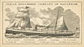 | Details | Ocean Steamship Company of Savannah | 1886 |
| Antique Trade Card for the Ocean Steamship Company of Savannah Georgia |
|
Ocean Steamship Company of Savannah |
|
| 1886 |
| LOC:41 |
| $270.00 | Ocean-Steamship-Company-of-Savannah | Antique-Trade-Card-for-the-Ocean-Steamship-Company-of-Savannah-Georgia | Rare trade card for the <b>Ocean Steamship Company of Savannah</b>. This antique trade card records the names of steamships and their sailing dates for this Savannah, Georgia based shipping company.
<br></br>
The Ocean Steamship Company of Savannah was founded in 1872 with passenger and cargo service between the cotton export port of Savannah, Georgia and the northern export ports of New York and Boston. This company was a subsidiary of the Central of Georgia Railway and was integral in moving cotton from Georgia and Alabama to New York and Boston, Massachusetts over the next seventy years.
<br></br>
Steamships listed on the card include:
<div class="indenttextblock">
<ul style="list-style-type: circle;">
<li>City of Augusta</li>
<li>Chattahoochee></li>
<li>Tallahassee></li>
<li>City of Savannah></li>
</ul>
</div>
Sailing dates listed on the back of the card are for routes from New York to Savannah, GA. during November 1886. |
| 993 | 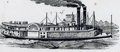 | Details | Anonymous | 1866 |
| Steamboat Bill of Lading for Valence Plantation |
|
Anonymous |
|
| 1866 |
| LOC:1 |
| $500.00 | Anonymous | Steamboat-Bill-of-Lading-for-Valence-Plantation | Rare post civil war shipping document, a "Bill of Lading", for the steamboat <b>Belle Ida</b> to transport items from New Orleans, Louisiana to Valence Plantation, along Bayou Lafourche, in Assumption Parish. <b>Valence Plantation</b> was most likely located near the current-day town of Supreme, just a few miles south of the well-known Madewood Plantation and Naploeonville, Louisiana. Dated within to February 9th, 1866. The bill of lading was filled in by hand at time of shipping and is addressed to J.B. Savage, Valence Plantation, Bayou Lafourche.
<br></br>
Bayou Lafourche has not been navigable from the Mississippi River since 1905 when a dam was built at Donaldsonville, La. but prior to that time the waterway served as an important commercial artery.
<br></br>
The Belle Ida was likely a stern-wheel steamboat built in 1861 (Wooldridge Steamboat List. <a href="https://www.umsl.edu/mercantile/collections/pott-library-special-collections/assets/pdf/collections/Woold_Ridge_Steamboat_list.pdf" target="_blank">Internet </a>). With a stock logo of a side-wheel steamboat by T. Fitzwilliam, Stationer and Printer, 76 Camp Street, N.O.
<br></br>
Symonds, Courtney and Co. were Tobacco Factors and General Forwarding and Commission Merchants located at No. 35 Natchez Street, New Orleans, LA. With a glued 2 cent stamp within. Addressed on verso.
<br></br>
The items shipped from New Orleans by Symonds Courtney and Co. included:
<ul style="list-style-type: none;">
<li>1 sack of harnesses</li>
<li>1 bundle of bridles</li>
<li>5 cases of sundries</li>
<li>10 head of mules</li>
<li>1 horse</li>
<ul/> |
| 391 | 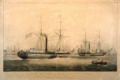 | Details | Huggins, W.J. | 1842 |
| Ships of the General Steam Navigation Company, Off Rotterdam. |
|
Huggins, W.J. |
|
| 1842 |
| LOC:0 |
| $600.00 | Huggins--W-J- | Ships-of-the-General-Steam-Navigation-Company--Off-Rotterdam- | Hand-colored aquatint by William John Huggins from 1842 of the steamers Giraffe and Ocean in Rotterdam Harbor. In the foreground a small boat is shown ferrying passengers dressed in Dutch clothing of that era. <BR> </BR>
The steam side-wheelers Giraffe and Ocean were both launched in 1836 and operated as mail steamers for the General Steam Navigation Company (GSNC) . Not the Robert E. Lee ( ex Giraffe), a Civil War Confederate blockade runner built in 1862 with twin stacks.
<BR> </BR>
The GSNC was founded in 1824 in Greenwich, England. For 150 years the firm was London's top short-sea shipping service with routes between the ports of Britain and north west Europe.
<BR> </BR>
Attribution line below the print reads: "Painted by W.J. Huggins, marine painter to his late majesty William IV. London. Published by Mr. Huggins 105 Leadenhall Street. 1842. Engraved by E. Duncan." |
| 289 |  | Details | Providence, Fall River and Newport Steamboat Co. | 1904 |
| Brochure- Providence , Fall River and Newport Steamboat Co |
|
Providence, Fall River and Newport Steamboat Co. |
|
| 1904 |
| LOC:0 |
| $165.00 | Providence--Fall-River-and-Newport-Steamboat-Co- | Brochure--Providence---Fall-River-and-Newport-Steamboat-Co | Scarce antique eight-page brochure and map for the Providence, Fall River and Newport Steamboat Company, 136 Dyer Street, Providence, Rhode Island. This small brochure, dated internally to 1904, contains time tables, descriptive information on each port and sightseeing tips and advertisements from local businesses and resorts.
<BR> </BR>
Contains a list of the eight steamers comprising the company's fleet and their passenger capacity:
<div class="indenttextblock">
<ul style="list-style-type: circle;">
<li>Mount Hope - 2000 persons</li>
<li>Warwick - 2000 persons</li>
<li>Richard Borden - 1500 persons</li>
<li>City of Newport - 1100 persons</li>
<li>Favorite - 1100 persons</li>
<li>What Cheer - 750 persons</li>
<li>Squantum - 850 persons</li>
<li>Baltimore - 500 persons</li>
</ul>
</div> |
| 134 |  | Details | Anonymous | 1882 |
| Track Chart Anchor Line Transatlantic Service |
|
Anonymous |
|
| 1882 |
| LOC:0 |
| $90.00 | Anonymous | Track-Chart--Anchor-Line-Transatlantic-Service | Small antique ship's track chart of the Atlantic Ocean produced by the Anchor Line shipping company and used by passenger "Bertie Brown" to track his progress on a Transatlantic cruise. Details the daily position on a voyage from Ireland to New York departing September 29, 1882. Document on card stock folds into 3 parts. Front cover lists vessels owned by Anchor Line with their tonnage. With a profile view of a steamer underway. Expands to 10"x6". |
| 135 |  | Details | Anonymous | 1902 |
| Track Chart Anchor Line American Mail Steamships |
|
Anonymous |
|
| 1902 |
| LOC:0 |
| $85.00 | Anonymous | Track-Chart--Anchor-Line-American-Mail-Steamships | Antique ship's track chart of Atlantic Ocean produced by the Anchor Line shipping company that was used by a passenger to track his progress on a Transatlantic cruise. Details the daily latitude and longitude on a 2689 mile voyage of the SS Anchonia between New York and Glasgow on Aug 9th - 19th, 1902. Daily position plots indicate a more northerly path than usual. <BR> </BR>
Document on card stock folds into 3 parts. Front cover lists vessels owned by Anchor Line with their tonnage and shows a frontal view of a steamer underway. Expands to 10"x6" |