| | Thumbnail | | Creator | Date | Title / Author / Date / Location | Price | | | Description |
| 7987 |  | Details | Harrison, John | 1784 |
| A New Chart of the Sandwich Islands including oWhyhee Hawaii |
|
Harrison, John |
|
| 1784 |
| LOC:130 |
| $1,100.00 | Harrison--John | A-New-Chart-of-the-Sandwich-Islands-including-oWhyhee-Hawaii | Engraved chart of the Hawaiian Islands issued shortly after the publication of the official account of Captain Cook’s third voyage (James King; June, 1784). This chart was published one month later in London by Harrison & Co., on July 1, 1784. It traces the routes of Cook’s ships Resolution and Discovery through the Hawaiian archipelago and highlights “oWhyhee” (Hawaiʻi), where Cook met his death in February 1779.
<br><br>
Based closely on Henry Roberts’ official chart but without the inset of Kealakekua Bay, Harrison’s version was created for a popular audience eager for news of the famous explorer’s final journey.
The map offers one of the earliest separately issued depictions of the Hawaiian Islands, capturing the moment when they first entered European geographic consciousness.
<br><br>
Printed from a finely engraved copper plate, the chart combines geographic accuracy with contemporary drama, naming each island and noting Cook’s fatal landing. Examples of this edition are far scarcer than those bound in the official voyage atlas, making it a sought-after piece for collectors of Pacific exploration and early Hawaiian cartography.
<br><br> |
| 6811 | 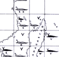 | Details | Maury, Matthew Fontaine | 1956 |
| Matthew Maury's Whale Chart Third Ed |
|
Maury, Matthew Fontaine |
|
| 1956 |
| LOC:68 |
| $1,900.00 | Maury--Matthew-Fontaine | Matthew-Maury-s-Whale-Chart-Third-Ed | Rare world-wide thematic chart of reported whale sightings by Matthew Fontaine Maury. Provides data on whale sightings by season, geographic area, whale species, and relative frequency. First published in 1851 but this 3rd edition re-issued in 1956 by the U. S. Navy Hydrographic Office.
<br><br>
Maury's Whale Chart provided valuable information about the migratory patterns of various whale species based on data collected from whalers and merchant ships and depicted the seasonal movements of different whale species in the Atlantic and Pacific Oceans. It included information about the regions where whales were most commonly found during specific times of the year, helping whalers optimize their efforts and increase their chances of successful hunts.
<br><br>
The last three editions of Maury's Whale Chart may be identified thus:
<div class="indenttextblocksingle">
<ul style="list-style-type: circle;">
<li><b>Third Edition (1956)</b></br>
Upper top left position with logo of eagle clutching items in claws surrounded by text: "Hydrographic Office U.S. Navy". Top right position is blank. Bottom right position reads "Price 20 cents / H.O. Miscel. No. 8514".</li>
<li><b>Fourth edition (1960)</b></br>
Upper top left position with logo of eagle over an anchor surrounded by text: "United States Hydrographical Office". Top right position reads "Catalog: Introduction. Part 1.". Bottom right position reads "Price 50 cents / H.O. Miscel. No. 8514" .
</li>
<li><b>Fifth edition (after 1972)</b></br>
Upper top left with logo containing an eagle perched on a globe with text "Defense Mapping Agency". Top right position reads "Catalog P2V10". Bottom right reads "Lith of Wm. Endicott & Co. N. York | 5018 | DMA Stock Number | W0XZC5018.</li>
</ul>
</div> |
| 6735 | 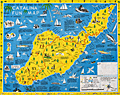 | Details | Ramsey, George | 1947 |
| Scarce pictorial fun map of Santa Catalina Island |
|
Ramsey, George |
|
| 1947 |
| LOC:89 |
| $295.00 | Ramsey--George | Scarce-pictorial-fun-map-of-Santa-Catalina-Island | <br><div class="indenttextblocksingle"><b>For a lasting remembrance of a grand vacation!</b> Keep this souvenir fun-map and mark the points you visit and the dates. Trace the routes of your travels on Catalina. Send copies to friends</div>
<br><br>
Where to go - What to see Santa Catalina Island fun map. A post-WWII pictorial map of Catalina Island, California. Copyright by George Ramsey. Published 1947 by Recreation Publishing Company, Los Angeles, CA. Price when issued 25 cents. Features include: Location of Ling-Ho Chinese junk movie set; Seal Rocks; submarine gardens; Chicago Cubs Ball Park and training grounds; the Catalina Visitors Country Club and much more.
<br><br>
Verso with map for Avalon Town |
| 6730 | 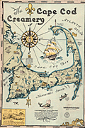 | Details | Gaffney, Walter M. | 1933 |
| Pictorial advertising map for the Cape Cod Creamery |
|
Gaffney, Walter M. |
|
| 1933 |
| LOC:13 |
| $550.00 | Gaffney--Walter-M- | Pictorial-advertising-map-for-the-Cape-Cod-Creamery | Historical pictorial map for Cape Cod Creamery ca. 1933 by Walter M. Gaffney. An unrecorded advertising piece for Cape Cod Creamery, associated with Noble's milk. On heavy card stock. Maps numerous historical and geographic locations including Pilgrim Monument, the Highland Light, Pleasant Bay, the Sandy Neck Light, the Cape Cod Canal. Scattered in each corner is a logo for Noble's milk, the map shows several delivery trucks labeled "Noble's that's good milk", and the large compass rose with a bottle of milk arranged at the center. Small piece of contiguous card stock apparently fashioned into a print hanger suggests the piece may have been trimmed into this shape by a previous owner.
<br><br>
Includes Buzzards Bay, Duxbury Bay, Provincetown Harbor, Wellfleet Harbor, Barnstable Harbor, Pleasant Bay, and a portion of Nantucket Sound.
<br><br>
<div class="indenttextblocksingle">
"Wellfleet or Whalefleet as it was originally called undoubtedly surpassed other towns. In 1843 a whale was captured near the end of the Cape and estimated to contain 200 barrels of oil and 2000 pounds of bone. Only 125 barrels of oil and 300 lbs. of bone were saved but with this waste it netted $10,000."
</div>
<br><br>
Gaffney is also credited with a larger pictorial map of Cap Cod 1932, in a different style, less historically oriented. |
| 5438 | 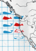 | Details | FAO United Nations | 1970 |
| Map of the world distribution of sperm and baleen whale catches |
|
FAO United Nations |
|
| 1970 |
| LOC:78 |
| $200.00 | FAO-United-Nations | Map-of-the-world-distribution-of-sperm-and-baleen-whale-catches | Scarce map of the number of catches of sperm whales and of baleen whales worldwide. From the "Atlas of the living resources of the seas" a publication of the Department of Fisheries for the <strong>Food and Agricultural Organization of the United Nations [1]</strong>.
<br><br>
Updating Maury one hundred years earlier, the color of whale pictographs are used to represent whale species. Location, and catch quantity also are represented on this chart of the world. Maury's chart reported whale sightings for sperm, baleen, and right whales, while this chart displays data on actual catches only of sperm and baleen whales.
<br></br>
[1] Online. Atlas of the living resources of the ses. United Nations FAO. http://www.fao.org/geonetwork/srv/en/metadata.show?id=9505&currTab=simple
<br></br>
(Atlas des resources biologiques des mers; Atlas de los recursos vivos del mar) |
| 5420 | 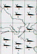 | Details | Maury, Matthew Fontaine | 1972 |
| Maurys Whale Chart 5th Edition |
|
Maury, Matthew Fontaine |
|
| 1972 |
| LOC:0 |
| $1,500.00 | Maury--Matthew-Fontaine | Maurys-Whale-Chart-5th-Edition | Scarce official U.S. thematic chart of reported whale sightings by geographic area, whale species, and relative number of sightings (5th ed. ca. 1972). An early example of the graphical display of quantitative information for decision making. The chart shows the best whaling areas and migration patterns for sperm whales and right whales, as well as the most densely populated areas of "Straggling" Sperm Whales and Right Whales." Chart # 5018.
<br></br>
Matthew Maury's Whale Chart, was first issued by the United States Bureau of Ordnance & Hydrography in 1851. This is the official U.S. fifth (5th.) edition, from the United States Defense Mapping Agency Hydrographic/Topographic Center in the 1970s. The DMA existed from 1972 through 1996. The first edition of Maury's Whale Chart is extremely rare on the market. Only one sale of Maury's chart is recorded in the Antique Map Price Record.
<br/></br/>
The last three editions of Maury's Whale Chart may be identified thus:
<div class="indenttextblocksingle">
<ul style="list-style-type: circle;">
<li><b>Third Edition (1956)</b></br>
Upper top left position with logo of eagle clutching items in claws surrounded by text: "Hydrographic Office U.S. Navy". Top right position is blank. Bottom right position reads "Price 20 cents / H.O. Miscel. No. 8514".</li>
<li><b>Fourth edition (1960)</b></br>
Upper top left position with logo of eagle over an anchor surrounded by text: "United States Hydrographical Office". Top right position reads "Catalog: Introduction. Part 1.". Bottom right position reads "Price 50 cents / H.O. Miscel. No. 8514" .
</li>
<li><b>Fifth edition (after 1972)</b></br>
Upper top left with logo containing an eagle perched on a globe with text "Defense Mapping Agency". Top right position reads "Catalog P2V10". Bottom right reads "Lith of Wm. Endicott & Co. N. York | 5018 | DMA Stock Number | W0XZC5018.</li>
</ul>
</div> |
| 4771 | 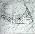 | Details | U.S. Coast and Geodetic Survey | 1916 |
| Nantucket Sound Massachusetts |
|
U.S. Coast and Geodetic Survey |
|
| 1916 |
| LOC:53 |
| $1,200.00 | U-S--Coast-and-Geodetic-Survey | Nantucket-Sound-Massachusetts | Fine antique engraved nautical chart first issued in 1915 covers the southeast portion of Cape Cod trending south and includes Hyannis Harbor, Tuckernuck Island and the islands of Nantucket, Monomoy, Chatham and eastern Nantucket Sound.
<br></br>
This bright antique chart bears a stamp at the bottom right in black ink that identifies this edition as corrected to May 29, 1916. Plate number 3446 for this 1915 ed. replaced the previous edition of 1909 which used plate number 2999. With the circular logo of the Department of Commerce and Labor. Chart number 111. |
| 1192 | 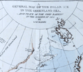 | Details | Manby, George William | 1823 |
| Journal of a Voyage to Greenland, in the year 1821 |
|
Manby, George William |
|
| 1823 |
| LOC:0 |
| $1,800.00 | Manby--George-William | Journal-of-a-Voyage-to-Greenland--in-the-year-1821 | An arctic whaling classic. Scarce second edition (1823) of this illustrated account of the whaling ship Baffin’s voyage with Captain Scoresby. The main purpose of the voyage was to test a new harpoon design by Scoresby. The voyage took them first to Spitzbergen, along the coast of Greenland, to Iceland and then home.
<br></br>
George Manby accompanied Captain Scoresby on the voyage into the northern Greenland Sea aboard the whaling ship Baffin. Manby creates a vivid picture of Arctic whaling as it was practiced during the early part of the 19th Century. Scoresby invented a harpoon gun and is also remembered for his life-saving apparatus. Numerous woodcuts in the text of whales, narwhal, and other arctic creatures.
<br></br>
With a fine hand-colored folding map "A General Map of the Polar Ice in the Greenland Sea and Track of the Ship Baffin in the Summer of 1821 by G.W. Manby (14" x 10"). Contains 20 uncolored lithographic plates illustrating the voyage. Five plates "Drawn on stone by J.D. Harding" are larger and folded:
<div class="indenttextblock">
<ul style="list-style-type: circle;">
<li>Striking a Whale with Third Harpoon</li>
<li>A Whale Upsetting a Boat</li>
<li>Lancing a Whale</li>
<li>A Bear Attacking A Boat</li>
<li>A Boat Going on the Tail of a Fish</li>
</ul>
</div>
In 1819 William Scoresby moved to Liverpool from Whitby where he built (1820) and commanded the whaling ship "Baffin". In 1822 Scoresby mapped the East coast of Greenland. The "Baffin" finally sank in 1830 when 19 out of 90 ships in the whaling fleet were lost in bad weather in the Davis Strait. Scoresby's plans, together with this scale model of his ship are in the Whitby Museum, Yorkshire, England.<a href="http://www.whitbymuseum.org.uk/hpmimages/index1.htm " target="_blank"> (Internet. 2016.)</a>
<br></br>
Printed for G. and W.B. Whittaker, Ave Maria Lane, London. 225 pages including an appendix illustrated with woodcuts of harpoons and lance heads. |
| 1182 | 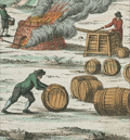 | Details | Wilhelm, Gottlieb Tobias | 1808 |
| Antique engravings of whaling and walrus hunting. |
|
Wilhelm, Gottlieb Tobias |
|
| 1808 |
| LOC:0 |
| $150.00 | Wilhelm--Gottlieb-Tobias | Antique-engravings-of-whaling-and-walrus-hunting- | A group of two antique copper-plate engraved pages containing scenes that show how mariners have exploited the aquatic environment for food or for the acquisition of wealth.
<br></br>
The upper print depicts a shore-based whale butchery and oil rendering location. In the foreground workers strip blubber from the dead whale lying in the shallows; a large fire burns nearby where the blubber would be boiled down to oil. Workers tend the fire and fill numerous wooden barrels with the whale oil, and at the end of the scene horse and wagon are shown to suggest the transfer of the oil barrels to another location.
<br></br>
The lower plate depicts a ships crew in a small rowboat firing upon a herd of walrus. While some of the crew fires their long guns other crew members use their oars to maintain the boats position and steady the rocking boat.
<br></br>
From G. T. Wilhelm's Encyclopedia of Natural History: Mankind. Augsburg, 1804. Gottlieb Tobias Wilhelm (1758-1811) was a Bavarian clergyman and naturalist known as the German Buffon |
| 1183 |  | Details | Wilhelm, Gottlieb Tobias | 1808 |
| Antique copper-plate engravings of whales |
|
Wilhelm, Gottlieb Tobias |
|
| 1808 |
| LOC:0 |
| $150.00 | Wilhelm--Gottlieb-Tobias | Antique-copper-plate-engravings-of-whales | A group of two antique copper-plate engraved pages containing charming depictions of several species of whales. These species are noted in manuscript on the page near each whale.
<br></br>
From G. T. Wilhelm's Encyclopedia of Natural History: Mankind. Augsburg, 1804. Gottlieb Tobias Wilhelm (1758-1811) was a Bavarian clergyman and naturalist known as the German Buffon |
| 1156 | 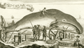 | Details | Anonymous | 1744 |
| A Whale Female and the Windlass whereby the Whales are brought on shore |
|
Anonymous |
|
| 1744 |
| LOC:1 |
| $275.00 | Anonymous | A-Whale-Female-and-the-Windlass-whereby-the-Whales-are-brought-on-shore | Fine antique copper-plate engraving of a dead whale lying on the Greenland shore prior to flensing. A worker has marked a grid on the whale and is about to begin work removing the blubber with a large flensing tool. Shore-based flensing or cutting of the whales flesh was the method used by Nantucketer's during their early shore fishery . As the fishery moved offshore flensing was conducted by bringing the whale alongside the whaling ship. Illustrates Monck's "Account of a Most Dangerous Voyage to Greenland".
<br></br>
Shows windlasses, a sled, anchor, and flensing tools used to haul the carcass ashore and remove the whale's blubber.
<br></br>
Originally published in 1619, this state is from Churchill's Collection of Voyages & Travel (1744) vol. I. Page 444. |
| 1150 | 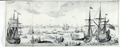 | Details | Narbrough, John | 1694 |
| Early 17th century engraved whaling scene |
|
Narbrough, John |
|
| 1694 |
| LOC:1 |
| $300.00 | Narbrough--John | Early-17th-century-engraved-whaling-scene | Early foldout engraved bookplate (1697) depicting a whaling scene to illustrate Friedrich Martens' observations on northern whaling. Attractive antique print shows multiple whaling ships and ships boats engaged in harpooning, fighting, and flensing whales. A fine gift.
<br></br>
The view lends insight into the methods used to hunt whales in the early 17th century in the whaling grounds of the far northern latitudes like Greenland and the island of Spitsbergen, Norway. For example the ship at far right is shown tied off to an iceberg, a practice noted by Narbrough in the text. <div class="indenttextblock"> "When they sail some Miles into the Ice, where there is pretty large Ice-fields, they joyn their Ships to them with great Ice-hooks, fastned to strong Cables, where they lie at Anchor, several Ships about the same Ice-field, but they rather chose to be alone, because they are an hindrance to one another in Whale catching, and the hunting of them from one to another maketh them shie. (Online: http://darwin-online.org.uk/converted/Ancillary/BeagleLibrary/1694_Narborough_A813.html")</div>
</br>
Originally published in 1694 to accompany "The First Part of the Voyage into Spitsbergen and Greenland.", this record of recent voyages made by Sir John Narborough, Abel Tasman, John Wood and Friderich Martens. Narborough's journal records his voyage to the Straits of Magellan and his interest in the lands and peoples he encountered from 1669 to 1671.
<br></br>
This fine antique print illuminates Friedrich Martens' (1635 - 1699) observations on Spitsbergen and whaling in northern waters in 1671. |