| | Thumbnail | | Creator | Date | Title / Author / Date / Location | Price | | | Description |
| 5374 | 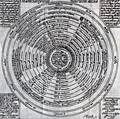 | Details | Millot, Philippe | 1620 |
| Rare celestial diagram by engraver Philippe Millot. |
|
Millot, Philippe |
|
| 1620 |
| LOC:13 |
| $550.00 | Millot--Philippe | Rare-celestial-diagram-by-engraver-Philippe-Millot- | Rare celestial diagram signed by French master engraver Philippe Millot ca 1620: "Totius Corporeæ Machinæ ex 12 Coelis et 4 Elementis Compactæ Descriptio." Folio 98.
<br></br>
No copy of this item is found online. Latin text. |
| 1043 |  | Details | de Fer, Nicolas | 1690 |
| Title Page for Les Costes de France |
|
de Fer, Nicolas |
|
| 1690 |
| LOC:1 |
| $120.00 | de-Fer--Nicolas | Title-Page-for-Les-Costes-de-France | Very cool and interesting title page with a depiction of numerous late 17th century maritime activities attending harbor work.
<br></br>
This title page was produced by the well known French geographer and cartographer, Nicolas de Fer (1646 - 1720). De Fer was a prolific producer of maps and prints who among other honors, was appointed as official geographer to the Spanish King in 1702. Published in de Fer's atlas: "Les Costes de France sur l'Océan et la Mer Mediterranee..." with 32 engraved charts. That work was a re-issue of Christophe Tassin's 1634 work "Cartes Generale et Particulieres de toutes le costes de France tant de la mer Oceane que Mediterranee". |
| 1434 | 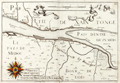 | Details | de Fer, Nicolas | 1690 |
| Scarce French chart of Medoc Bordeaux wine region |
|
de Fer, Nicolas |
|
| 1690 |
| LOC:7 |
| $450.00 | de-Fer--Nicolas | Scarce-French-chart-of-Medoc-Bordeaux-wine-region | For the lover of <b>Bordeaux wines</b>, this fine antique French map encompasses the Bordeaux wine region along France's Gironde, Garonne and Dordogne Rivers. Our 17th-century coastal map is Nicolas de Fer's re-issue of N. Tassin's original engraved map / chart (ca. 1640) of the area. Landmarks of the Bordeaux region noted on the map include le Pays de Medoc, Partie de Xaintonge, Margos (Margaux), Macan, Saint-Julien, Petit Bordeaux, S. Estienne (Saint-Estephe ?), Bourg de Blaye, Pauilliac, Listra (Listrac-Medoc ?). Number 23.
<br></br>
Originally published circa 1640 by N. Tassin whose engravings are of special interest as the first French atlas to focus solely on France's coastal margins. Tassin has a distinctive style characterized by his use of images of numerous sailing vessels, and his large, elaborate compass roses.
<br></br>
This map was produced with royal privilege by the well known French geographer and cartographer, Nicolas de Fer (1646 - 1720). De Fer was a prolific producer of maps and prints who among other honors, was appointed as official geographer to the Spanish King in 1702.
<br></br>
de Fer bought rights to Tassin's atlas- "Cartes Generale et Particulieres de toutes le costes de France" added his imprint and title page, and re-issued the work. Published in de Fer's atlas: "Les Costes de France sur l'Océan et la Mer Mediterranee..." with 32 engraved charts. That work was a re-issue of Christophe Tassin's 1634 work "Cartes Generale et Particulieres de toutes le costes de France tant de la mer Oceane que Mediterranee". |
| 1425 | 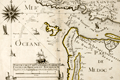 | Details | de Fer, Nicolas | 1690 |
| Scarce French chart of Bordeaux region with Pauilliac Grand-Cru |
|
de Fer, Nicolas |
|
| 1690 |
| LOC:7 |
| $500.00 | de-Fer--Nicolas | Scarce-French-chart-of-Bordeaux-region-with-Pauilliac-Grand-Cru | For the lover of Bordeaux wines, this fine antique French map encompasses the northwestern Bordeaux region of France including the area now occupied with the village of Pauilliac and three of the Grand-Crus vineyards of Bordeaux: Lafite-Rothschild, Mouton-Rothschild, and Latour. Our 17th-century coastal map is Nicolas de Fer's re-issue of N. Tassin's original engraved map / chart (ca. 1640) of the Gironde River mouth. Other landmarks of the Bordeaux region (not drawn anywhere close to scale) include Coste de Medoc (appellee Coste Sauvage) , I. Cordouan, Royan, Soulac-sur-Mer, Carcans, and Lacanau. Number 22.
<br></br>
Checking Google Maps along the estuary of the Gironde River we find an area of the left bank with several river outlets opposite large islands. The major town is not Tassin's or de Fer's "Palus" but Pauilliac.
<br></br>
Originally published circa 1640 by N. Tassin whose engravings are of special interest as the first French atlas to focus solely on France's coastal margins. Tassin has a special style characterized by his use of images of numerous sailing vessels, and his large, elaborate compass roses.
<br></br>
This map was produced with royal privilege by the well known French geographer and cartographer, Nicolas de Fer (1646 - 1720). De Fer was a prolific producer of maps and prints who among other honors, was appointed as official geographer to the Spanish King in 1702.
<br></br>
de Fer bought rights to Tassin's atlas- "Cartes Generale et Particulieres de toutes le costes de France" added his imprint and title page, and re-issued the work. Published in de Fer's atlas: "Les Costes de France sur l'Océan et la Mer Mediterranee..." with 32 engraved charts. That work was a re-issue of Christophe Tassin's 1634 work "Cartes Generale et Particulieres de toutes le costes de France tant de la mer Oceane que Mediterranee". |
| 893 | 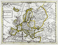 | Details | Moll, Herman | 1736 |
| Europe and the Near East |
|
Moll, Herman |
|
| 1736 |
| LOC:0 |
| $0.00 | Moll--Herman | Europe-and-the-Near-East | SOLD
<br></br>
Antique map of Europe, Greenland, Turkey, Persia, and North Africa by Herman Moll. Note for Groenland (Greenland) states: "Ice and Mountains covered with snow." Geographic relief is depicted in a simple pictorial style. This old map of Europe is from the 3rd edition of Moll's "Atlas Minor: or a New and Curious Set of Sixty-two Maps", published for Thomas and John Bowles in 1736. |