| | Thumbnail | | Creator | Date | Title / Author / Date / Location | Price | | | Description |
| 1367 | 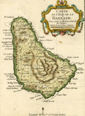 | Details | Bellin, Jacques Nicolas | 1754 |
| Small antique map of Barbados in the Caribbean |
|
Bellin, Jacques Nicolas |
|
| 1754 |
| LOC:0 |
| $0.00 | Bellin--Jacques-Nicolas | Small-antique-map-of-Barbados-in-the-Caribbean | SOLD <br></br>
Small antique map of Barbados by J.N. Bellin. This hand-colored map shows the island of Barbados, a Caribbean island in the Lesser Antilles. Barbados was an English colony at the time this little map was printed. Depicts the capital city of Barbados- Bridgetown as well as many other towns, island parishes and attractive interior topographic detail.
<br></br>
Published in the 15-volume "Histoire Generale des Voyages" of Antoine François Prévost. Published from Paris in 1754. Tome 15. Page 567. |
| 1451 | 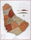 | Details | Jefferys, Thomas | 1775 |
| Mayo Jefferys Sayers Chart of Barbados West-India Atlas |
|
Jefferys, Thomas |
|
| 1775 |
| LOC:0 |
| $0.00 | Jefferys--Thomas | Mayo-Jefferys-Sayers-Chart-of-Barbados-West-India-Atlas | SOLD<BR></BR>
Fine antique British chart of the Island of Barbados in the Caribbean Sea. With two inset coastal elevation views of Barbados as seen from W.N.W. at a distance of 9 leagues (27 mi.) offshore and 7 leagues (21 mi.) offshore. Barbados is an island country in the Lesser Antilles, in the Caribbean region of North America. After a survey by William Mayo. Sheet X.
<br></br>
The chart is from the scarce <b>first issue of The West-India Atlas, 1775 by Sayer</b>, the other issues being 1781, 1787, 1794, 1796, 1807, and 1818 published by Sayer and then later by Laurie and Whittle. <a href="https://www.davidrumsey.com/home" target="_blank">(Online).</a>
<br></br>
"The West-India Atlas: or, A Compendious Description of the West-Indies: illustrated with Forty Correct Charts and Maps, taken from Actual Surveys. Together with An Historical Account of the Several Countries and Islands which compose that part of the world. Their Discovery, Situation, Extent, Boundaries, Product, Trade, Inhabitants, Strength, Government, Religion, &c."
<br></br>
Authors: William Mayo, Thomas Jefferys.
Publishers: Robert Sayer.
Jefferys died in 1771; Sayer acquired Jefferys' materials in preparation for this atlas, and published the atlas posthumously under his name.
Publisher's attribution reads: London, Printed for Robert Sayer, Map and Printseller Number 53 in Fleet Street as the act directs 20 February 1775. |
| 5327 | 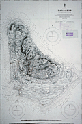 | Details | British Admiralty Hydrographical Office | 1917 |
| Admiralty sea chart of Barbados Bajan |
|
British Admiralty Hydrographical Office |
|
| 1917 |
| LOC:51 |
| $1,250.00 | British-Admiralty-Hydrographical-Office | Admiralty-sea-chart-of-Barbados-Bajan | Fine engraved antique nautical chart of the Island of Barbados first published by the British Admiralty in 1869 from a survey by Staff Commander J. Parsons, R.N. assisted by Navigating Lieut. H. R. Harris & G. Stanley R. N. This edition of the Barbados chart was published at the Admiralty on Feb. 26, 1873. This issue contains the latest corrections from 1917.
<br></br>
Two inset profile views of Barbados at bottom. Chart number 2485.
<br></br>
With two ink stamps for chart sellers from South America: Thomas Bruzzone e Hijos, Buenos Aires and Rodolfo Bosenberg, Libros y Mapas Maritimos [Buenos Aires]. |