| | Thumbnail | | Creator | Date | Title / Author / Date / Location | Price | | | Description |
| 8079 | 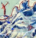 | Details | Sink, John | 1948 |
| Scarce pictorial map of western North Carolina |
|
Sink, John |
|
| 1948 |
| LOC:41 |
| $450.00 | Sink--John | Scarce-pictorial-map-of-western-North-Carolina | Western North Carolina: a vacationist's map and guide is a colorful mid-20th century pictorial map ca. 1948 illustrated by John Sink, a commercial artist known for lively regional tourist imagery. The map presents the Blue Ridge and Great Smoky Mountains as a continuous mountain chain extending from the Tennessee line eastward across western North Carolina ending at the Sauratown Mountains with Hanging Rock State Park.<br><br>
Peaks, gaps, and valleys are shown in bold, sculptural relief, while towns such as Asheville, Boone, and Bryson City anchor the geography. Cartoon figures hiking, skiing, fishing, and sightseeing animate the landscape, emphasizing recreation and leisure ("The Fun") rather than precise navigation.<br><br>
Designed as both a guide and a promotional image, the map combines expressive illustration with practical travel information. Major highways and scenic routes, including the Blue Ridge Parkway, trace the mountain ridges, while airplanes, automobiles, and roadside signage reflect the postwar rise of leisure travel by car and air. An inset conventional road map ("The Hiways") at lower right shows a detailed network of highways serving western North Carolina, reinforcing the sheet's function as both a souvenir image and a usable tourist guide.
<br><br>Text on verso with twelve proposed routes for scenic tours throughout the region. |
| 8077 | 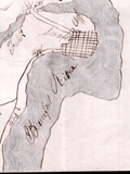 | Details | Unknown Union Source | 1862 |
| The Port Royal Experiment Manuscript Civil War Map Beaufort SC |
|
Unknown Union Source |
|
| 1862 |
| LOC:89 |
| $4,500.00 | Unknown-Union-Source | The-Port-Royal-Experiment-Manuscript-Civil-War-Map-Beaufort-SC | This Civil War–era manuscript map of Beaufort, South Carolina and its surrounding waterways documents the region at the birth of Reconstruction ca. 1862. The map is perhaps the earliest record during what became known as the <b>Port Royal Experiment</b>, when Union occupation, emancipation, and continued military conflict unfolded at the same time. The map shows inland roads, ferries, and navigable rivers, identifies numerous named plantations, and records Union and Confederate picket positions, defensive rifle pits near Beaufort, the battlefield at Port Royal Ferry, and notations of Confederate shelling. It reflects a landscape under Union control but still actively contested.<br><br>The most striking feature of the map is the large number of plantations recorded and the size of the text used to describe plantation ownership vs the military detail. After Union forces captured the Beaufort area in late 1861, most plantation owners fled, leaving more than ten thousand emancipated Gullah people on intact estates without pay, supplies, or legal protection. Beginning in 1862, Northerners arrived to address immediate problems: preventing starvation, organizing paid work, starting schools, and safeguarding newly won freedom for the formerly enslaved. For teachers, missionaries, Treasury agents, and Army officers, a map like this was a working tool. It showed where people lived, where food and cotton were stored, how plantations were connected by roads and waterways, and which routes could be traveled with relative safety. |
| 6716 | 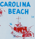 | Details | Greater Wilmington Chamber of Commerce | 1958 |
| New Hanover County Pictorial Fishing Map Mid century |
|
Greater Wilmington Chamber of Commerce |
|
| 1958 |
| LOC:86 |
| $175.00 | Greater-Wilmington-Chamber-of-Commerce | New-Hanover-County-Pictorial-Fishing-Map-Mid-century | Pictorial fishing map from 1958 of New Hanover County, NC. Drawn by Art Newton. Shows pictorially many locations for public fishing piers, surf fishing spots, wrecks, charter boats, boat launches and more. Soundings are provided near the beach and numerous inlets are identified including Carolina Beach Inlet, Masonboro Inlet, Moore Inlet, and Rich Inlet. Decorated with local fish: Flounder, Dolphin, Amberjack, Barracuda, Sailfish, and Bonito.
<br><br>
Copyrighted and published by the Greater Wilmington Chamber of Commerce, 1958. Printed by the Wilmington Printing Company, Wilmington, North Carolina.
<br><br> |
| 6648 |  | Details | Seaboard Air Line Railway | 1917 |
| Military Camps Winter Resorts Map Florida |
|
Seaboard Air Line Railway |
|
| 1917 |
| LOC:150 |
| $800.00 | Seaboard-Air-Line-Railway | Military-Camps-Winter-Resorts-Map-Florida | Rare patriotic WWI map titled "Military Camps and Nearby Resorts. Winter Near Your Soldier Boy." This fine 31 inch long antique map was published by Seaboard Airline Railway in 1917. Outstanding and emotionally evocative graphics on the cover with a fine thematic promotional map on the recto.
<br><br>
<div id="0" align="center">
<a title=""></a>
<img id="6648" src="/ZoomifyImages/SC_6648/SC_6648_cover_detail.jpg" alt="WWI map titled "Military Camps and Nearby Resorts. Winter Near Your Soldier Boy" published by Seaboard Airline Railway Florida." width="100"/> <br><br> <font size="-2">Military Resorts Cover Art</font>
</div><br>
Only one holding is found in WorldCat, at Rutgers. WorldCat's mildly cynical one-line summary of the map reads <b>"War as a tourist industry for elegant ladies & gentlemen."</b> (1)
<br><br>
This full-size folding map shows twenty-eight locations (Army, Navy, and Aero training camps) served by the Seaboard Air Line Railway where a spouse (wife) could travel to spend the winter holidays with her soldier (husband) during 1917, the fourth year of WWI. The camps and stations of the U.S. Army were indicated with red square symbols, those of the Navy with circles, and Aero Stations by triangles. The U.S. Army Air Service, as it was then called, was established after April, 1917 making this map one of the earliest available maps to show Pensacola as an Naval Air Training Station.
<br></br>
These Army, Navy, and Aero training locations, described in the key at bottom right, include Pensacola, Tampa, and Key West, Florida; New Orleans, Louisiana; Charleston, South Carolina; and Port Royal, SC.
<br></br>
Brochure folds to 4" x 9". Printed by Poole Brothers, Chicago and dated within at 8/16/1917.
<br><br>
(1) WorldCat. Online. Accessed: January, 2023 |
| 6631 |  | Details | Fenner, Marie | 1969 |
| Original Pictorial Map of Columbia SC Beautiful Capital City by Fenner |
|
Fenner, Marie |
|
| 1969 |
| LOC:500 |
| $595.00 | Fenner--Marie | Original-Pictorial-Map-of-Columbia-SC-Beautiful-Capital-City-by-Fenner | Now virtually unobtainable historic-pictorial map of Columbia, South Carolina "surveyed and delineated by Marie Fenner in 1968-69 A.D.". Olde South Galleries. The map's border is surrounded with drawings of local Columbia and regional South Carolina historical scenes including:
<div class="indenttextblocksingle">
<ul style="list-style-type: circle;">
<li>Confederate printing plant 1864</li>
<li>Palmetto Armory and Iron Works - 1850</li>
<li>Ainsley Hall Mansion</li>
<li>The Fisher-Bachman House</li>
<li>The Horry-Guinard House 1818</li>
<li>The Governor's House</li>
</ul>
</div>
Only one copy of Fenner's Historic Savannah found online, in WorldCat, at the University of South Carolina, Columbia SC. No sales recorded in AMPR.
<br><br>
Copyright 1969 by Old South Galleries. 1st Printing.
<br><br>
Created by offset lithography in 1969 using the halftone process (1). On 20th century laid paper. Verso is blank |
| 6632 | 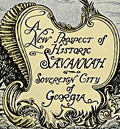 | Details | Fenner, Marie | 1968 |
| Rare 1968 Savannah, Georgia Sovereign City Pictorial Map by Marie Fenner |
|
Fenner, Marie |
|
| 1968 |
| LOC:500 |
| $695.00 | Fenner--Marie | Rare-1968-Savannah--Georgia-Sovereign-City-Pictorial-Map-by-Marie-Fenner | An attractive, tourist-oriented historic-pictorial map of Savannah, Georgia full of sketches of local architecture and interesting details of the city. At top center Fenner has drawn an image of James Edward Oglethorpe, the first Governor of Georgia.
<br><br>
As with other maps Fenner created in the late 1960's the map's border is surrounded with drawings of local and regional historical scenes including:
<div class="indenttextblocksingle">
<ul style="list-style-type: circle;">
<li>Fort Pulaski</li>
<li>Tybee Light- 18th Century</li>
<li>Cathedral of St. John the Baptist</li>
<li>Forsyth Park</li>
<li>The City Hall- Griffin Park</li>
<li>Davenport House</li>
<li>Monterey Square- General Pulaski Monument</li>
<li>Fort Jackson, and Fort Wayne</li>
</ul>
</div>
Only one copy is found online, in WorldCat, at the University of South Carolina, Columbia SC.
<br><br>
Copyright 1968 by Old South Galleries.
<br><br>
Printed in 1968 using the halftone process (1). Bottom right corner: Charleston Lithographing Co. On 20th century laid paper with an illegible watermark. Verso is blank |
| 6597 | 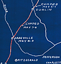 | Details | McClelland S.W. Kincaid R.L. et al | 1941 |
| Cyanotype (blueprint) map of the Route of Jefferson Davis in Spring 1865 |
|
McClelland S.W. Kincaid R.L. et al |
|
| 1941 |
| LOC:3 |
| $200.00 | McClelland-S-W--Kincaid-R-L--et-al | Cyanotype-(blueprint)-map-of-the-Route-of-Jefferson-Davis-in-Spring-1865 | Unrecorded and interesting cyanotype map of the route of Confederate General Jefferson Davis as he fled south after the Civil War from Charlotte, North Carolina to the city of Irwinville, Georgia where he hoped to escape to a foreign country. The map shows key rivers crossed and locations where Jefferson Davis stopped along the route.
<br><br>
Creators were Dr. S.W. McClelland, Dr. R.L. Kincaid, Dr. J.M. Nicholson, and C.P. Williams in August. 1941. This blueprint map is yet another scarce example of how an early photographic reproduction technology allowed individuals to disseminate their own unique works, bypassing traditional publishing technologies and institutions. |
| 6435 | 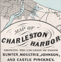 | Details | Weiss, Jacob | 1861 |
| Map of Charleston Harbor |
|
Weiss, Jacob |
|
| 1861 |
| LOC:10 |
| $2,150.00 | Weiss--Jacob | Map-of-Charleston-Harbor | Unrecorded edition of "Map of Charleston Harbor [South Carolina] showing the location of forts ..." printed by Jacob Weiss at 600 Chestnut Street, Philadelphia in 1861. Inset elevation or perspective view of Charleston at top.
<br><br>
My interpretation of the map suggests Weiss printed the map between December 27, 1860, when the Union surrendered Shutes Folly/Castle Pinckney to the S.C. militia but before April 12, 1861 when the Confederacy began bombardment of Union forces at Fort Sumter. During this period the public had an intense interest in the building conflict.
<br><br>
Shows the main channel from the Atlantic Ocean to Charleston docks. Circles represent the range of cannon fire from forts and batteries in vicinity of Charleston Harbor, Charleston, South Carolina. Key features include:
<div class="indenttextblocksingle">
<ul style="list-style-type: circle;"></li>
<li>Shutes Folly Island with Castle Pinckney</li>
<li>Rebellion Road [2]</li>
<li>US Arsenal</li>
<li>Customs House</li>
<li>Mount Pleasant</li>
<li>Sullivan's Island</li>
<li>Drunken Dick Breakers</li>
<li>Fort Johnson and Fort Sumter</li>
</ul>
</div>
WorldCat shows only two similar institutional holdings - Hagley Museum & Library, and University of Michigan Clements Library. This edition is similar to the edition at the U. Michigan Clements Library but lacks the price, and the Clements copy lacks both the decorative border, and the "Perspective View of the Harbor and City of Charleston" at top.
<br><br> |
| 5492 | 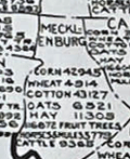 | Details | State and City Bank and Trust Richmond VA | 1922 |
| Map NC and SC with principal 1922 crop acreages |
|
State and City Bank and Trust Richmond VA |
|
| 1922 |
| LOC:10 |
| $295.00 | State-and-City-Bank-and-Trust-Richmond-VA | Map-NC-and-SC-with-principal-1922-crop-acreages | Thematic advertising map of North Carolina and of South Carolina with 1922 acreage statistics related to crops, livestock and other agricultural resources. Contains several inset tables of summary statistics:
<div class="indenttextblocksingle">
<ul style="list-style-type: circle;">
<li>Principal SC 1922 crop acreages (Cotton was #1 at nearly 2.2 million acres)</li>
<li>SC 1921 crop and sales value (Cotton #1 at $61M made up nearly half of SC crop output)</li>
<li>NC 1922 Crop acreages.</li>
<li>A marketing schedule for major agricultural crops and livestock: "When Carolina Crops are Marketed"</li>
</ul>
</div>
Lithographed. The maps are based on data provided by the U.S. Bureau of Markets and U.S. Bureau of Crop Estimates. A discreet call to action in inset text at far right: "You need some kind of banking service every day … Banking by Mail is one of our specialties … Our resources exceed $21,500,00." |
| 5429 |  | Details | Price, Matthew | 1983 |
| Historical Map of Duck and Beyond |
|
Price, Matthew |
|
| 1983 |
| LOC:200 |
| $155.00 | Price--Matthew | Historical-Map-of-Duck-and-Beyond | Pictorial map of Currituck Sound, the Atlantic Ocean and the Outer Banks in the vicinity of Duck, Dare County, North Carolina. Created by Matthew Price in 1983.
<br></br>
This "Historical Map of Duck and Beyond" is decorated with scenes typical to the area near Duck, North Carolina (past and present): crabs, whales, wild flowers, shipwrecks, and ducks.
<br></br>
Price shows the street network and notes many points of interest on that narrow strip of land in the Outer Banks including:
<div class="indenttextblocksingle">
<ul style="list-style-type: circle;">
<li>Old Navy bombing range (no bombing allowed during hunting season).</li>
<li>Powder Ridge Gun Club</li>
<li>Caffey's inlet station</li>
<li>Maurice and Bea's Decoy Shops</li>
<li>Home and duck shop of "Pop" Scarborough</li>
<li>Ocean Beach campground</li>
<li>Duck Woods Golf Course</li>
<li>Old site of Martin's Point Club</li>
<li>Carolina Dunes</li>
</ul>
</div> |
| 5339 | 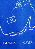 | Details | Somberg, Seymour I. | 1950 |
| Blueprint plat map of Cedar Grove Plantation St. Paul South Carolina |
|
Somberg, Seymour I. |
|
| 1950 |
| LOC:1401 |
| $900.00 | Somberg--Seymour-I- | Blueprint-plat-map-of-Cedar-Grove-Plantation-St--Paul-South-Carolina | Unrecorded blueprint or cyanotype plat map of <b>Cedar Grove Plantation</b> or Smythe Plantation, <b>St. Paul / Summerton, South Carolina</b> in Clarendon County with Robert Adger Smythe (1871-1962) , Manager. The blueprint was created ca. 1950 and signed by Seymour. I. Samberg L.S. (Land Surveyor) with property lines taken from an earlier plat by Bushner and Rutledge dated May 30, 1914. North oriented to lower left.
<br></br>
Robert Adger Smythe was born in Charleston, S.C. in 1871 and graduated from the Citadel in 1890. He founded the Lambda Chapter fraternity at the Citadel. Smythe spent most of his business years in cotton brokerage in Atlanta. Robert Smythe did not live at Cedar Grove, but visited often, conducting his business through manager Joe. H. King.
<br></br>
The earliest record of Cedar Grove Plantation dates to 1796 when Jack Lawson laid out a plantation of 2,160 acres between Jack's Creek and Taw-Caw. In the mid-1800's the plantation had grown to over 5,000 acres.
Nearby features on this plat map include Jack's Creek, Highway 15, Manning Turnpike, Lake Marion, Nelson's Ferry Road, and St. Paul.
<br></br>
Legend at bottom right includes the signature of Seymour Somberg. In 1953 Seymour I. Somberg was listed as President of Forestry Aids (forestry - surveying) in Manning, South Carolina. [1]
<br></br>
[1] Eller, Robert C. ed. Surveying and Mapping. Volume XIII, No. 1 January - March, 1953. p. 252. (Online) |
| 3607 | 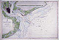 | Details | British Admiralty Hydrographical Office | 1918 |
| Large Chart of Charleston Harbor, South Carolina |
|
British Admiralty Hydrographical Office |
|
| 1918 |
| LOC:53 |
| $1,250.00 | British-Admiralty-Hydrographical-Office | Large-Chart-of-Charleston-Harbor--South-Carolina | Fine British Admiralty chart of Charleston Harbor, South Carolina based on U.S.C.G.S. charts to 1914. This edition with corrections to 1918. Named features Include Folly Island, Morris Island, James Island, Sullivan Island, and the Isle of Palms. From the copper plate engraved by J & C Walker.
<br></br>
Later edition of a British Admiralty chart first engraved and published from London in 1869, and updated with corrections after that.
<br></br>
Bold dark lithographed print retains the cartographic look and style of the late 19th century. Logo of the British Hydrographical Office at top of the title block. Published from London on April 1, 1869 . Number 2324 |
| 1421 | 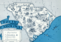 | Details | Johst, Paul Spener | 1931 |
| South Carolina Pictorial Map |
|
Johst, Paul Spener |
|
| 1931 |
| LOC:41 |
| $85.00 | Johst--Paul-Spener | South-Carolina-Pictorial-Map | Pictorial map of the State of South Carolina in a cartoon-like style. Depicts transportation (mules), agriculture (tobacco, rice, watermelon, cotton, corn) for the State of South Carolina in an exaggerated, stereotyped manner. A decorative legend at bottom left identifies four locations within South Carolina: Charleston, Columbia, Greenville, and Spartanburg. Page 57.
<br></br>
Verso with text extolling the virtues of South Carolina geography and natural wonders.
<br></br>
From "Picture Map Geography of the United States" by Vernon Quinn. With Picture Maps by Paul Spener Johst. Publisher: Frederick A. Stokes Company. New York. 1931. Some picture maps in the book contain depictions that today might be considered politically incorrect or even racist. |
| 1136 |  | Details | Wilson, John F. | 1979 |
| Decorative pictorial map of Manteo, North Carolina |
|
Wilson, John F. |
|
| 1979 |
| LOC:52 |
| $225.00 | Wilson--John-F- | Decorative-pictorial-map-of-Manteo--North-Carolina | Interesting pictorial map of downtown Manteo, North Carolina on Roanoke Island along Shallowbag Bay. This very decorative map is packed with features of daily life on Roanoke and provides a street map and birds-eye view of Manteo downtown ringed by pictures reflecting its maritime heritage including boats, sea chests, seagulls, oars, antique furniture, anchors, and foodstuffs.
<br></br>
A number of local historical homes are featured including the George Howard Creef House; the Forbes Nixon House; the Meekins House; the James Bonner House; and "The Old House" or George Washington Creef House, said to be one of the oldest structures then standing in downtown Manteo. Other key features pictured on the map are the Pioneer Theater; the Roanoke Island Volunteer Fire Department; Water Oak at Mother Vineyard; and the Dare County Courthouse.
<br></br>
About the courthouse Wilson notes:
<div class="indenttextblock"> "Erected 1904, replacing a wooden 1873 structure. The land for the building was donated by John Wescott in 1870 when the county of Dare was formed from the counties of Hyde, Tyrrell and Currituck. It was named in honor of Virginia Dare, the first child of English parents born in the New World."
</div>
<br />
Manteo is located on Roanoke Island, part of North Carolina's Outer Banks. Named the seat of government for Dare County in 1870, Manteo incorporated in 1899 and in 2010 had a population of just 1434 persons.
<br></br>
Published by John F. Wilson IV in 1979. |
| 892 | 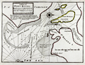 | Details | Moll, Herman | 1736 |
| Antique Chart of Port Royal Harbor, South Carolina |
|
Moll, Herman |
|
| 1736 |
| LOC:3 |
| $425.00 | Moll--Herman | Antique-Chart-of-Port-Royal-Harbor--South-Carolina | This antique chart of <b>Port Royal Sound</b>, drawn by Herman Moll before 1732, is the earliest obtainable large-scale chart focused on the Port Royal / Beaufort, South Carolina area and one of the earliest to name <b>Hilton Head</b>. With locations identified for two proposed forts guarding the main channel to "Bauford Town" (Beaufort), which was located by Moll on Parris Island ("Port Royal Island"). Other noted features include St. Helena Island, with Phillips Point and St. Michaels Head. Numerous soundings and sandbars are indicated.
<br></br>
Moll added this description of the area below the title block: <div class="indenttextblock">"Port Royal River lies 20 Leagues from Ashley River SW it has a bold entrance 19 or 20 foot at low-water. The Harbor is large, safe, and commodious and runs into ye best country in Carolina. Here ye air is always cleer and agreeable to Europian constitutions".</div>
</br>
This old map of Port Royal, Hilton Head, and Beaufort S.C. is from the 3rd edition of Moll's "Atlas Minor: or a New and Curious Set of Sixty-two Maps", published for Thomas and John Bowles in 1736. |
| 682 |  | Details | U.S. Coast and Geodetic Survey | 1860 |
| Albemarle Sound North Carolina |
|
U.S. Coast and Geodetic Survey |
|
| 1860 |
| LOC:52 |
| $675.00 | U-S--Coast-and-Geodetic-Survey | Albemarle-Sound-North-Carolina | Original, antique rolled U.S. Coast Survey chart of the Western portion of Albemarle Sound published in 1860. Produced under the supervision of A.D. Bache, Superintendent of the Survey of the Coast of the United States. Within a mile or so of the riverine margins each building, field, and plot of land are drawn in fine detail. With sailing directions and an explanation of navigation using the ranges. Based on triangulation and hydrography executed between 1847 - 1849.
<br></br>
Coverage of this fine antique chart include the towns of Plymouth, Edenton, Columbia, Hertford, Nixonton, and Elizabeth City, North Carolina; the Cashai (Cashie) River; Pocosson Swamp; Roanoke River; Chowan River; Bull Bay; Scuppernong River; Perquamons (Perquimans) River; Bear Garden Point; Little River; Redbank Land; and Truebloods Point.
<br></br>
This antique navigation chart should not be confused with those similar copies issued as part of a Report to Congress, most on thin paper with folds that often show condition issues. This original mid 19th century survivor is a large, separately issued example on thick paper that has been stored either rolled of flat with no folds.
<br></br>
Numerous soundings, lighthouses, and other aids to navigation are noted. With the logo of the Coast Survey Office. Price $1.50 when issued. |
| 581 | 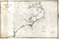 | Details | British Admiralty Hydrographical Office | 1871 |
| Albemarle Sound to Cape Fear |
|
British Admiralty Hydrographical Office |
|
| 1871 |
| LOC:0 |
| $720.00 | British-Admiralty-Hydrographical-Office | Albemarle-Sound-to-Cape-Fear | Antique, rolled, British Admiralty sea chart of the coast of North Carolina ( NC ). This lithographed chart, although issued by the Admiralty Hydrographic Office in London, is based on work by the U.S. Coast Survey ca. 1847 and is dated to the edition of 1871. Numerous soundings, aids to navigation, inlets, rivers, and hazards are noted.
<br></br>
Coverage extends from Currick Sound / Elizabeth City, N.C. south to Little River Inlet at the border with South Carolina. A sampling of the many noted points of interest include: Cape Fear, Cape Lookout, Cape Hatteras, Albemarle Sound, Pamplico Sound, Core Sound, Holden Beach, Neuse River, Ocracoke Inlet and Ocracoke Island, Beaufort, Wilmington, Elizabeth City, and at the very bottom, Frying Pan Shoals.
<br></br>
This antique sea chart was first published at the Admiralty in London on November 30, 1861 under the superintendence of Captain Washington, R.N.: F.R.S. Hydrographer. Sold by J.D. Potter, agent for the Admiralty Charts. 31 Poultry and 11 King Street Tower Hill (London). Number 2826. Price when issued was half a crown. |
| 1041 | 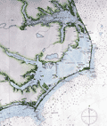 | Details | British Admiralty Hydrographical Office | 1871 |
| 1871 Chart of the Outer Banks, Albemarle Sound to Cape Fear |
|
British Admiralty Hydrographical Office |
|
| 1871 |
| LOC:53 |
| $1,600.00 | British-Admiralty-Hydrographical-Office | 1871-Chart-of-the-Outer-Banks--Albemarle-Sound-to-Cape-Fear | Antique, British Admiralty sea chart of the North Carolina Outer Banks in outstanding condition. Although issued by the Admiralty Hydrographic Office in London, this chart is based on work by the U.S. Coast Survey ca. 1847 and is dated with corrections to May, 1871. Numerous soundings, aids to navigation, inlets, rivers, and hazards are noted, particularly in Onslow Bay, Raleigh Bay, and the coastal inlets.
<br></br>
Coverage extends from Currick Sound / Elizabeth City, N.C. south to Little River Inlet at the border with South Carolina. A sampling of the many noted points of interest include: Cape Fear, Cape Lookout, Cape Hatteras, Albemarle Sound, Pamplico Sound, Core Sound, Holden Beach, Neuse River, Ocracoke Inlet and Ocracoke Island, Beaufort, Wilmington, Elizabeth City, and at the very bottom, Frying Pan Shoals.
<br></br>
This antique sea chart was first published at the Admiralty in London on November 30, 1861 under the superintendence of Captain Washington, R.N.: F.R.S. Hydrographer. Sold by J.D. Potter, agent for the Admiralty Charts. 31 Poultry and 11 King Street Tower Hill (London). Number 267. |
| 419 | 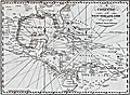 | Details | Malham, John | 1797 |
| A Correct Chart of the West India Islands engraved for Malham's Naval Gazetteer |
|
Malham, John |
|
| 1797 |
| LOC:3 |
| $375.00 | Malham--John | A-Correct-Chart-of-the-West-India-Islands-engraved-for-Malham-s-Naval-Gazetteer | Increasingly scarce on the market. Rev. John Malham's chart of the United States east coast lying south of Charlestown, South Carolina. Covers the Gulf of Mexico, Cuba, Bahamas, Hispaniola, the West Indies, Central America, Columbia, and Venezuela south to the mouth of the Orinoco River. This chart has examples of interesting usage of terms that are today known only from history books: 'Spanish Main' for the southern Caribbean Sea; 'Terra Firma' denotes northern Colombia and Venezuela. Key noted cities include Charleston, Savannah, St. Augustine, New Orleans, Havana, Port Royal, Cartagena, Caracas.
<br></br>
From the rare first American edition of Malham's Naval Gazetteer, published by Spotswood and Nancrede in Boston in 1797. Early U.S. colonial nautical chart engravings are scarce.
<BR> </BR>
This chart comes from an early nautical gazetteer or geographical dictionary produced first in England and after 1796 in the United States by John Malham a prolific Yorkshire-born author who produced other diverse works that include "Navigation Made Easy and Familiar". |