| | Thumbnail | | Creator | Date | Title / Author / Date / Location | Price | | | Description |
| 2495 | 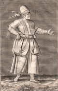 | Details | Baudier, Michel | 1659 |
| Moorish slave |
|
Baudier, Michel |
|
| 1659 |
| LOC:1 |
| | Baudier--Michel | Moorish-slave | Scarce copperplate engraving of a male Moorish slave (Esclave more) by Nicolas de Nicolay from "L'histoire de la décadence de l'empire grec et establissement de celuy des Turcs."
<br></br>
Nicolas de Nicolay (1517-1583), was a French geographer. In 1556 de Nicolay received the official title of "geographer of the king." In 1551, Henry II ordered Nicolas de Nicolay to follow Gabriel Aramon, during an embassy to the Grand Turk Suleiman the Magnificent. During this trip through Malta, Algeria, Libya, and the Greek islands he made 800 to 900 drawings of sites, cities, islands, ports, castles and fashion. Page 38. |
| 2496 | 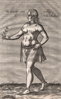 | Details | Baudier, Michel | 1659 |
| Young female Moorish slave of Algiers |
|
Baudier, Michel |
|
| 1659 |
| LOC:1 |
| $225.00 | Baudier--Michel | Young-female-Moorish-slave-of-Algiers | Scarce copperplate engraving of a young female Moorish slave (Fille moresques esclave) by Nicolas de Nicolay from "L'histoire de la décadence de l'empire grec et establissement de celuy des Turcs."
<br></br>
Nicolas de Nicolay (1517-1583), was a French geographer. In 1556 de Nicolay received the official title of "geographer of the king." In 1551, Henry II ordered Nicolas de Nicolay to follow Gabriel Aramon, during an embassy to the Grand Turk Suleiman the Magnificent. During this trip through Malta, Algeria, Libya, and the Greek islands he made 800 to 900 drawings of sites, cities, islands, ports, castles and fashion. Page 38. |
| 729 | 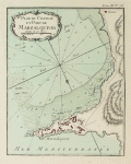 | Details | Bellin, Jacques Nicolas | 1764 |
| Plan du Chateau et Port de Marzalquivir |
|
Bellin, Jacques Nicolas |
|
| 1764 |
| LOC:4 |
| $150.00 | Bellin--Jacques-Nicolas | Plan-du-Chateau-et-Port-de-Marzalquivir | Antique port plan du Chateau et Port de Marzalquivir ( Algeria ) by J.N. Bellin in "Le Petit Atlas Maritime ". Tome 3 Number 76. |
| 4847 | 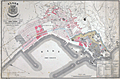 | Details | Vigouroux and Caillat | 1858 |
| Algiers, Algeria City Renewal Proposal 1858 |
|
Vigouroux and Caillat |
|
| 1858 |
| LOC:62 |
| $1,150.00 | Vigouroux-and-Caillat | Algiers--Algeria-City-Renewal-Proposal-1858 | Rock the Casbah!
<br></br>
Rare lithographed map of a proposed renovation and expansion project for Algiers in 1858. By Vigououx, surveyor and Caillat of France's Ponts and Chaussees (Bridges and Roads). At bottom left, the map is dedicated in manuscript ink, signed by the author (Caillat) to Colonel Marengo, then the Mayor of the commune of Douéra. Just a few years previously Marengo had been Commander of the Citadel of Algiers or the Casbah, and apparently still retained some influence. The citadelle or Casbah is shown marked near bottom right, but in a broader sense the Casbah was
<div class="indenttextblock">
"the ancient core of Algiers, the triangular-shaped town carved into the hills facing the Mediterranean … the sea forms the base of the triangle; a citadel is at the triangle's summit. (Celik, Zeeynep. Algiers under French Rule in "Urban Forms and Colonial Confrontations. University of California Press. 1997.) </div>
<br></br>
Shows the "rivage actuel" or the existing shoreline with the new construction that would occur to complete the project in those areas.
<br></br>
Background: the French invaded Algeria in 1830. In 1834, Algeria became a French military colony and was subsequently declared by the constitution of 1848 to be an integral part of France and divided into three departments: Alger, Oran and Constantine. |