| | Thumbnail | | Creator | Date | Title / Author / Date / Location | Price | | | Description |
| 657 |  | Details | Hulsius, Levinus | 1626 |
SOLD
Capture of Cacafuego |
|
Hulsius, Levinus |
|
| 1626 |
| LOC:1 |
| $0.00 | Hulsius--Levinus | SOLD-<br></br>Capture-of-Cacafuego | Nicely engraved antique depiction of the fierce battle between the Spanish treasure ship Nuestra Senora de Ia Concepcion ( Cacafuego ) and the Golden Hind ( Caca Plata ) of Sir Francis Drake near Esmereldas, Ecuador in March 1579. As a result of that battle Drake captured the Cacafuego with an immense treasure of gold, silver, and jewels. Drake was knighted by the Queen on his return to Plymouth with the treasure after a three year voyage.
<br></br>
Anonymous engraver for this copperplate engraved edition of 1626 after the work of Levinus Hulsius. |
| 3599 | 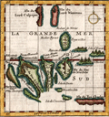 | Details | Moll, Herman | 1699 |
| First printed map focused on the Galapagos Islands (French ed.) |
|
Moll, Herman |
|
| 1699 |
| LOC:0 |
| $0.00 | Moll--Herman | First-printed-map-focused-on-the-Galapagos-Islands-(French-ed-) | SOLD <br></br>
French language version of this scarce map of the Galapagos Islands which is the <b>earliest printed map of the Galapagos</b>. This small antique engraved map was based on a manuscript map drawn by <b>William Ambrosia Cowley</b>. Cowley was sailing master of a pirate ship captained by John Eaton in 1684 when they made landfall at the Galapagos Islands in the Pacific Ocean. Cowley's narrative of the voyage- 'Cowley's Voyage Around the Globe' was published in English in the 'COLLECTION OF ORIGINAL VOYAGES' by William Hacke from London in 1699.
<br></br>
In Cowley's manuscript journal he recorded his first observations of the Galapagos:
<div class="indenttextblock">
"Then we came to an Anchor in a very good Harbour, lying toward the Northernmost end of a fine Island, under the Equinoctial Line: Here being great plenty of Provisions, as Fish, Sea and Land Tortoises, some of which weighed at least 200 Pound weight, which are excellent good Food. Here are also abundance of Fowls, viz. Flemingoes and Turtle Doves; the latter whereof were so tame, that they would often alight upon our Hats and Arms, so as that we could take them alive, they not fearing Man, until such time as some of our Company did fire at them, whereby they were rendered more shy." (Cowley, W.A., "Cowley's Voyage Around the Globe" <a href="http://www.galapagos.to/TEXTS/COWLEY.HTM#GalapagosSection" target="_blank">Internet</a>)
</div>
<br>
<b>Cowley's Names of the Galapagos Islands from the English Edition </b>
<div class="indenttextblocksingle">
<ul style="list-style-type: circle;">
<li>King Charles's Island
<li>Crossman's Island
<li>Brattles Island
<li>Sir Anthony Dean's Island
<li>Eure's Island
<li>Dassigney's Island
<li>Bindlos's Island
<li>Duke of York's Island
<li>Duke of Norfolk's Island
<li>Duke of York's Island
<li>Duke of Albemarle's Island
<li>Sir John Narborough's
<li>Cowley's enchanted Island
<li>Earl of Abington's Island
</ul>
</div> |
| 3631 |  | Details | Anville, Jean Baptiste Bourguignon d' | 1751 |
| Mid eighteenth-century French map of the Province of Quito |
|
Anville, Jean Baptiste Bourguignon d' |
|
| 1751 |
| LOC:88 |
| $350.00 | Anville--Jean-Baptiste-Bourguignon-d- | Mid-eighteenth-century-French-map-of-the-Province-of-Quito | Fine example of the single sheet version of Pedro Vicente Maldonado's map of the Province of Quito, one of the most important regional maps of South America published in the 18th Century. Includes the triangular network of survey lines la Condamine utilized in his survey.
<br></br>
The map is a reduced version of Maldonado's 4 sheet map published in Paris in 1750. This single sheet version was incorporated in La Condamine's authoritative account of the Spanish-French Geodesic Mission to the area, often referred to as the "la Condamine expedition".
<br></br>
This map was drawn by Jean-Baptiste Bourguinon d'Anville, one of the most celebrated French cartographers, and engraved by Guillaume Delahaye. This map was commissioned by Mr. de la Condamine to be included in his Journal du voyage fait par ordre du roi à l'équateur, servant d'introduction historique à la 'Mesure des trois premiers degrés du méridien', which was published in Paris by l'Imprimerie Royale in 1751.
<br></br>
Focused on what is today Ecuador, the map extends from Jaen on the Rio Maranon in what is now northern Peru, all the way northwards to Popayan (Colombia), and runs from the Pacific coast over the Andes to include the upper reaches of the Amazon Basin. Includes important cities such as Quito, Guayaquil, Cuenca, Popayan and Esmereldas. This vast area was one of the most challenging in the world to map, as it included thousands of square miles of coastal plains, volcanic peaks, and swamps. |
| 883 | 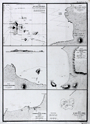 | Details | Duperrey, Louis-Isidore | 1827 |
| Old chart of the Galapagos Islands and anchorages |
|
Duperrey, Louis-Isidore |
|
| 1827 |
| LOC:0 |
| $550.00 | Duperrey--Louis-Isidore | Old-chart-of-the-Galapagos-Islands-and-anchorages | Antique French copper-plate engraved charts of the <b>Galapagos Islands</b> (Ecuador) and three ports in Colombia. Six charts and plans on a single sheet of heavy wove paper by Duperrey from the "Voyage autour du monde, exécuté par ordre du Roi, sur la corvette de Sa Majesté, La Coquille, pendant les années 1822, 1823, 1824 et 1825". Published by the Depot de la Marine - Hyd. Fr. N°. 725 N°. 42.
<br></br>
The charts include the following:
<div class="indenttextblock">
<ul>
<li>Carte des Iles Gallapagos d'aprés les observationes faites par Vancouver en 1791, par Davidson et le Capt. B. Hall en 1822. </li>
<li>Plan de la Baie Albany (Iles Gallapagos)</li>
<li>Plan de Mouillage de L'Ile Hood (Iles Gallapagos)</li>
<li>Plan de la Baye Salango (Colombie)</li>
<li>Plan du Mouillage de Tacames (Colombie)</li>
<li>Plan du Banc de la Perle (Ile de la Perle)</li>
</ul>
</div>
The <b>Banc de la Perle</b> is significant in that it was there that two British whalers grounded and were lost on April 24th, 1822. The combined crews salvaged parts and built a new vessel, the Deliverance, which some of the crew then sailed to Hawaii. The wreck site lay hidden until it was rediscovered by NOAA divers in 2004. <div class="indenttextblock"> (Pearl Site Survey 2006. National Oceanic and Atmospheric Administration.
<a href="http://sanctuaries.noaa.gov/maritime/expeditions/pearl.html" target="_blank">Internet</a>)
</div> |