| | Thumbnail | | Creator | Date | Title / Author / Date / Location | Price | | | Description |
| 126 | 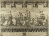 | Details | Anonymous | 1660 |
| Untitled - Stockholm mid 17th century |
|
Anonymous |
|
| 1660 |
| LOC:0 |
| $0.00 | Anonymous | Untitled---Stockholm-mid-17th-century | SOLD<BR> </BR>
Antique view of Stockholm with 'Admiralty Island' in the background records a procession of robed Senators and other nobles including King Carolus. In the distance to the left is the "Palatium Admiralitatis", the Skeppsholmen Admiralty palace built in 1650 and to the right- Kastellholmen. Depicts numerous naval vessels firing a salute. Contains emblems for Livonia, Scania, Finnonia Meridionalis, Finnonia Septentrionalis, and Uplandia. <BR> </BR>
It is unclear what occasion this engraving commemorates but it is likely after 1658 when Denmark was forced to cede control of Scania to Sweden. Possibly records the coronation procession of King Charles XI in 1672. |
| 314 | 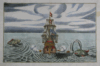 | Details | Wagner, Johann Christoph | 1684 |
| Untitled - Ship firing on attacking sea serpents |
|
Wagner, Johann Christoph |
|
| 1684 |
| LOC:0 |
| $800.00 | Wagner--Johann-Christoph | Untitled---Ship-firing-on-attacking-sea-serpents | Highly decorative, whimsical, rare antique wood-block nautical engraving of a sailing ship firing at sea monsters on both sides of the vessel. Ship bears an ensign of a forearm bearing a sword. A great chance to have a plate that was first published in Furtenbach's very scarce 1629 classic of naval architecture "Architectura Navalis" . <BR> </BR>
Note: Seller has attributed the source as Wagner's "Delineatio Provinciarum Pannoniae et Imperii Turciciin Oriente Eine Grundrichtige Beschreibung deß ganzen Aufgangs", published in Augsburg 1684. "N4" at upper left. |
| 662 | 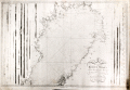 | Details | Nordenankar, Jan | 1790 |
| Chart of Northern Gulf of Bothnia ( Botten Wiken ) |
|
Nordenankar, Jan |
|
| 1790 |
| LOC:0 |
| $1,200.00 | Nordenankar--Jan | Chart-of-Northern-Gulf-of-Bothnia-(-Botten-Wiken-) | Scarce antique Swedish nautical sea chart by Nordenankar of the upper portion of the Gulf of Bothnia with portions of the coasts of Sweden and Finland. Includes these noted cities and features: Umea, Skelleftea, Pitea, Lulea, Tornio, (Tornea), Kemi, Oulu (Uleaborg), Brahestad, Jacobstad, and Kokkola ( Gamla Carleby ).
<br></br>
Produced by Swedish Admiral and cartographer Johan Corvin Nordenankar (1722-1804). Nordenankar, in order to gain major experience at sea early in his career, served in both the English and Maltese navies, participating in a battle between Maltese galleys and an Algerian ship on May 16, 1752. Returning home to Sweden, Nordenankar rose through the ranks of the Swedish navy first as Lieutenant-Commander and later in 1772 served as head of the galley fleet stationed in Stockholm.
<br></br>
Nordenankar is best known for his work as Director of the sjökarteverket, Sweden's nautical chart department, in the 1780's. During his tenure as Director he led the survey and charting of areas that previously were only poorly documented including the Baltic Sea with the Gulf of Bothnia and Gulf of Finland, the Sound, Kattegat and Skagerrak. These areas had become more important militarily to Sweden with Russia's advances into the region and improvements to the cartography of the area had stalled after initial work by Peter Gedda, Nils Power Crona, and Jonas Hahn. Nordenankar work leading the renewed charting of the region resulted in the publication of at least 11 charts under his name. (Reference: sok.riksarkivet.se/SBL/Presentation.aspx?id=8198)
<br></br>
Much hydrographic detail, soundings, and hazards. Left and right portions of the chart contain numerous profile views of the coastline as seen from sea. Engraved by Arkrel. Number 3. |
| 280 | 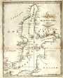 | Details | Malham, John | 1797 |
| A Correct Chart of the Baltic Sea engraved for Malham's Naval Gazetteer |
|
Malham, John |
|
| 1797 |
| LOC:7 |
| $150.00 | Malham--John | A-Correct-Chart-of-the-Baltic-Sea-engraved-for-Malham-s-Naval-Gazetteer | Small antique nautical chart showing the Baltic Sea, Gulf of Finland and surrounding coastal areas including Poland, Estonia, and Sweden (then including Finland). From the rare first American edition of Malham's Naval Gazetteer, published by Spotswood and Nancrede in Boston in 1797. Vol 1.<BR> </BR>
This sea chart comes from an antique nautical gazetteer or geographical dictionary produced first in England and after 1796 in the United States. Key noted cities include Copenhagen, Stockholm, and St. Petersburg. <BR> </BR>
Rev. John Malham was a prolific Yorkshire-born author who produced other diverse works that include "Navigation Made Easy and Familiar", "Twenty-Two Sermons on Doctrinal and Practical Subjects" and "The Scarcity of Wheat considered". Malham died near London in 1807. (Gentleman's Magazine, Vol 102, 1807, p. 568).<BR> </BR>
Colophon at end of Volume 1 states that the work is "From the prefs of Samuel Etheridge, No. 9 Newbury Street, Boston, 1797"). |
| 1351 | 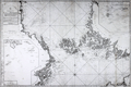 | Details | Nordenankar, Jan | 1800 |
| Scarce antique Swedish sea chart of the Baltic Sea with Stockholm |
|
Nordenankar, Jan |
|
| 1800 |
| LOC:0 |
| $1,600.00 | Nordenankar--Jan | Scarce-antique-Swedish-sea-chart-of-the-Baltic-Sea-with-Stockholm | Scarce antique Swedish nautical chart by Nordenankar of the Upper Baltic Sea and the lower portion of the Gulf of Bothnia. Sweden to the west, Finland to the east, the Aland Islands between the two, dominating the upper Baltic; Estonia in the lower right corner. Includes Stockholm and numerous other cities. Special charts inset include: "Sandhamns Inloop" and "Inloppet til Finska Uto".
<br></br>
Produced by Swedish Admiral and cartographer Johan Corvin Nordenankar (1722-1804). Nordenankar, in order to gain major experience at sea early in his career, served in both the English and Maltese navies, participating in a battle between Maltese galleys and an Algerian ship on May 16, 1752. Returning home to Sweden, Nordenankar rose through the ranks of the Swedish navy first as Lieutenant-Commander and later in 1772 served as head of the galley fleet stationed in Stockholm.
<br></br>
Nordenankar is best known for his work as Director of the sjökarteverket, Sweden's nautical chart department, in the 1780's. During his tenure as Director he led the survey and charting of areas that previously were only poorly documented including the Baltic Sea with the Gulf of Bothnia and Gulf of Finland, the Sound, Kattegat and Skagerrak. These areas had become more important militarily to Sweden with Russia's advances into the region and improvements to the cartography of the area had stalled after intial work by Peter Gedda, Nils Power Crona, and Jonas Hahn. Nordenankar's work leading the renewed charting of the region resulted in the publication of at least 11 charts under his name. (Reference: sok.riksarkivet.se/SBL/Presentation.aspx?id=8198)
<br></br>
Much hydrographic detail, soundings, and hazards. Left and right portions of the chart contain numerous profile views of the coastline as seen from sea. Engraved by Akerlund. Number 5. |
| 6476 | 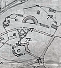 | Details | Rosen, Ludwig | 1890 |
| Engineers manuscript contour drainage plan of the Gärdet in Stockholm Sweden |
|
Rosen, Ludwig |
|
| 1890 |
| LOC:1402 |
| $900.00 | Rosen--Ludwig | Engineers-manuscript-contour-drainage-plan-of-the-Gärdet-in-Stockholm-Sweden | Early and rare engineer's pen and ink manuscript contour drainage plan of Stockholm's Ladugårdsgärdet [1] by States Engineer Ludwig Rosen in 1890. A hand-drawn and hand colored detailed plan on supple surveyors tracing cloth covering land that was at the time largely undeveloped. Today the outer portions of the Gärdet are well developed leaving a central open space that is part of Stockholm’s National City Park.
<br><br>
An important manuscript engineering plan related to urban growth, development, and the environmental preservation of Stockholm, Sweden.
<br><br>
<div id="0" align="center">
<a title="Täckdikningsplan for Ladugårdsgärde vid Stockholm"></a>
<img id="3" src="/ZoomifyImages/SC_6476/SCV_6476_Title.jpg" alt="Täckdikningsplan for Ladugårdsgärde vid Stockholm" width="300"/> <br><small>Title to Rosen's plan of the Ladugårdsgärde (1890)</small>
</div><br>
Plan shows land contour and numerous profile cross-section inset drawings. From a translation of the title "Täckdikningsplan" we can derive that the purpose of the plan was for the development of "cover ditches" or sub-surface drainage systems. North oriented to upper left. Detailed explanatory legend fills the left side of the plan.
<br><br>
[1] Ladugårdsgärdet or Gärdet is a suburb in Stockholm County east and northeast of Östermalm with a current population of roughly 21,500 residents. Until the mid 1800’s, the eastern areas of Stockholm were known as Ladugårdslandet, or “The Barn Land.” Throughout the 1900’s, large areas of Gärdet were developed. |