| | Thumbnail | | Creator | Date | Title / Author / Date / Location | Price | | | Description |
| 8085 |  | Details | Beech-Nut Packing Company | 1941 |
| Persuasive Map of Beech Nut Gum Radio Advertising |
|
Beech-Nut Packing Company |
|
| 1941 |
| LOC: |
| $350.00 | Beech-Nut-Packing-Company | Persuasive-Map-of-Beech-Nut-Gum-Radio-Advertising | Unrecorded large-format persuasive advertising map of the United States issued by Beech-Nut for the 1941-1942 radio season, boldly presenting the company’s national broadcast coverage. The country is rendered in bright yellow, overprinted with station call letters in red, while surrounding text proclaims that Beech-Nut advertising combines Red, Columbia, Blue, and Mutual stations "not possible to obtain on any single network." The sheet emphasizes scale and power, noting 172 stations, 38 of them 50,000-watt outlets, and nearly 1,000 Beech-Nut Gum and Beechies ads every week. The result is a striking visual inventory of American radio geography on the eve of World War II.<br><br>
The language makes clear that this was not intended for the general public. Instead, it was designed to persuade wholesalers, grocery chains, druggists, and regional distributors that Beech-Nut’s campaign reached every part of the country at night when radio audiences were largest. By highlighting 50,000-watt clear-channel stations in red and stressing multi-network placement, the map argues that Beech-Nut’s coverage exceeds what any single network could provide. It is, in effect, a sales instrument aimed at convincing the trade that consumer demand was being nationally manufactured and that retailers should stock accordingly.<br><br>
As an artifact, the piece documents a transitional moment in American broadcast advertising, when sponsors strategically assembled cross-network station lists to maximize reach. The map translates invisible airwaves into cartographic form, making corporate media strategy tangible. Combining commercial ephemera with radio history, it stands as an unusual and compelling intersection of cartography, marketing, and early 1940s national media infrastructure. |
| 8077 | 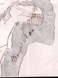 | Details | Unknown Union Source | 1862 |
| The Port Royal Experiment Manuscript Civil War Map Beaufort SC |
|
Unknown Union Source |
|
| 1862 |
| LOC:89 |
| $4,500.00 | Unknown-Union-Source | The-Port-Royal-Experiment-Manuscript-Civil-War-Map-Beaufort-SC | This Civil War–era manuscript map of Beaufort, South Carolina and its surrounding waterways documents the region at the birth of Reconstruction ca. 1862. The map is perhaps the earliest record during what became known as the <b>Port Royal Experiment</b>, when Union occupation, emancipation, and continued military conflict unfolded at the same time. The map shows inland roads, ferries, and navigable rivers, identifies numerous named plantations, and records Union and Confederate picket positions, defensive rifle pits near Beaufort, the battlefield at Port Royal Ferry, and notations of Confederate shelling. It reflects a landscape under Union control but still actively contested.<br><br>The most striking feature of the map is the large number of plantations recorded and the size of the text used to describe plantation ownership vs the military detail. After Union forces captured the Beaufort area in late 1861, most plantation owners fled, leaving more than ten thousand emancipated Gullah people on intact estates without pay, supplies, or legal protection. Beginning in 1862, Northerners arrived to address immediate problems: preventing starvation, organizing paid work, starting schools, and safeguarding newly won freedom for the formerly enslaved. For teachers, missionaries, Treasury agents, and Army officers, a map like this was a working tool. It showed where people lived, where food and cotton were stored, how plantations were connected by roads and waterways, and which routes could be traveled with relative safety. |
| 8052 | 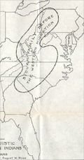 | Details | Connelley, William Elsey | 1920 |
| Lot of two maps Caddoan and Siouan Homelands and Westward Migration |
|
Connelley, William Elsey |
|
| 1920 |
| LOC: |
| $195.00 | Connelley--William-Elsey | Lot-of-two-maps-Caddoan-and-Siouan-Homelands-and-Westward-Migration | Two scarce maps pertaining to the Siouan and Caddoan linguistic families by William E. Connelley. Drawn by August Ross, the maps were published circa 1920.
<br><br>
The first map, titled Map Showing The Possessions Of The Caddoan And Siouan Linguistic Families Of North American Indians Before The Western Migration Of The Siouan's, presents a continental synthesis intended to depict original linguistic homelands rather than fixed political boundaries. The Caddoan family is shown occupying a Mississippi Valley core along the Arkansas, Red, and Platte river systems, while the Siouan family is placed mainly east of the Mississippi River. The enclosed regions represent long-term habitation zones derived from historical tradition, early European accounts, and linguistic comparison. The map establishes the argument that the Siouan peoples were later arrivals to the Plains, displacing an older Caddoan presence.
<br><br>
The second map, Map Showing The Original Caddoan Country After The Intrusion Into It Of The Siouan Linguistic Family, emphasizes movement and territorial contraction. Numbered regions and migration paths depict successive Siouan advances and the resulting fragmentation of Caddoan lands, isolating groups such as the Pawnee and Arikara. River corridors remain central, reinforcing the idea that waterways structured settlement and conflict. In contrast to the first map’s generalized homelands, this sheet focuses on process, showing encroachment, displacement, and the later imposition of reservation boundaries.<br><br> |
| 8024 | 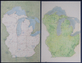 | Details | Paine, Howard E. | 1975 |
| Manuscript conceptual maps for Great Lakes–Midwest region |
|
Paine, Howard E. |
|
| 1975 |
| LOC:130 |
| $500.00 | Paine--Howard-E- | Manuscript-conceptual-maps-for-Great-Lakes–Midwest-region | Unpublished poster-size manuscript conceptual map ca. 1975 by National Geographic Art Director Howard Paine (1) presents a unified Great Lakes–Midwest region extending from Lake Superior to central Kentucky. Rendered in soft colored pencil and wash, the sheet studies regional physiography—rivers, watersheds, and upland structure—without the finished editorial layers of a production map. Paine experiments with state boundaries, drainage patterns, and implied landcover to test how a broad Midwest–Great Lakes treatment might read at atlas scale.
<br><br>
The verso carries a companion terrain study in the same hand, emphasizing elevation, forest cover, and hydrology with Paine’s characteristic, lightly modeled shading. Together the two drawings show the internal design process behind a National Geographic map that was never realized in print, offering a rare look at the developmental artwork that preceded formal cartographic production. They are among the few surviving privately-held examples of Paine’s pre-press regional concept work.<br><br> These conceptual sheets can be securely dated to the late 1960s through the mid-1970s, the period when National Geographic relied on hand-rendered shaded-relief masters and watercolor terrain studies for both its Atlas of the World (6th–8th editions) and the Close-Up U.S.A. series. The green land wash, blue-gray lake treatment, and pencil-modeled hydrology match the Society’s internal cartographic style of roughly 1968–1977, placing Howard Paine’s drafts squarely within that high phase of Nat Geo’s pre-digital map production. |
| 7921 |  | Details | Nicholson, Francis | 1838 |
| Public squares, parks, and places in the city of New York |
|
Nicholson, Francis |
|
| 1838 |
| LOC: |
| $450.00 | Nicholson--Francis | Public-squares--parks--and-places-in-the-city-of-New-York | Maps of sixteen parks, on one sheet, covering various locales south of 125th Street in Manhattan, New York. Each park map gives dimensions and acreage, shows layout of park walkways and surrounding streets.
<br><br>
From D.T. Valentines manual. 1838. H.R. Robinson, Lith. Compiled and surveyed by Francis Nicholson, City Surveyor. August, 1838.
<br><br>
The 1838 “Manual of the Corporation of the City of New York” is considered a precursor volume to Valentine’s later annual manuals. Compiled when David Thomas Valentine (1841-1870) was Assistant Clerk of the Common Council, it served as an early attempt to assemble civic data, city charters, ordinances, and maps into a single reference work.
This 1838 edition predates the regular annual series and is not always listed among the later “official” manuals (which began in 1841), but bibliographers recognize it as the first appearance of Valentine’s work in this format.
<br><br> |
| 7984 |  | Details | Howells, Rulon S. | 1961 |
| Map of The Mormon Exodus to the Rocky Mountains |
|
Howells, Rulon S. |
|
| 1961 |
| LOC: |
| $300.00 | Howells--Rulon-S- | Map-of-The-Mormon-Exodus-to-the-Rocky-Mountains | Scarce mid-20th-century educational wall poster depicts the westward migration of the Mormon pioneers from the eastern United States to the Great Salt Lake Valley. The map traces multiple overland and sea routes—from early settlements in New York, Ohio, and Illinois across Iowa, Nebraska, and Wyoming to Utah—with fine line work and green-toned shading that visually emphasizes the journey’s progression.
<br><br>
Illustrations along the route show covered wagons, handcarts, and pioneer figures, while smaller vignettes depict scenes such as the Mormon Battalion’s march and seaborne emigrant routes from Europe. At lower left, a narrative block summarizes the migration’s history, noting Brigham Young’s leadership and the founding of the Great Salt Lake settlement in 1847.
<br><br>
Printed in green and black on white stock, the map carries the imprint: “A Teaching Aid – The Mormon Story – Teaching Aids, Inc., Highland Park, Illinois.” This poster was likely used in classrooms and religious education settings during the 1960s, part of a broader trend toward illustrated historical maps as visual teaching tools. An attractive and informative example of mid-century American educational cartography.
<br><br>
Published by Bookcraft, Inc, 1961. |
| 7932 |  | Details | Kenyon Company | 1924 |
| Bankers Life Radio Map of the United States |
|
Kenyon Company |
|
| 1924 |
| LOC:41 |
| $300.00 | Kenyon-Company | Bankers-Life-Radio-Map-of-the-United-States | In 1924, American broadcasting was new enough to map. This Radio Map of the United States, engraved and published by the Kenyon Company of Des Moines with compliments of the Bankers Life Company, plots cities through their call signs. It is a document from the first radio boom, two years before the major networks formed, when individual stations defined the medium and listeners learned the geography of the air by call letters alone.
<br><br>
The design is simple and utilitarian. Time zone lines and numbered radio districts divide the country. Cities host their stations without decorative effects. The emphasis is informational: where a station is, what it is called, and how federal administration overlays the national map.
<br><br>
As advertising, the piece is direct. Bankers Life, calling itself the largest life insurer west of the Mississippi, links its presence to the spread of broadcasting. The sober printing and neat index give the map the tone of a directory while keeping the sponsor in view.
<br><br>
The call letters also tell a regulatory story. After 1912 the United States used the leading letters K, W, N, and A. For broadcasting, officials split K and W geographically and finalized the Mississippi River divide in 1923. New stations west of the river took K, those east took W, but early assignees kept their calls. That is why KDKA and KQV appear in Pittsburgh, east of the line. The 1924 sheet shows the new rule with the older exceptions still present.
<br><br>
A partial list of stations include:
<br><br> |
| 6863 |  | Details | Requa | 1947 |
| Very Rare Attractions Map of Florida |
|
Requa |
|
| 1947 |
| LOC:86 |
| $200.00 | Requa | Very-Rare-Attractions-Map-of-Florida | Fine lithographed pictorial map of Florida highlighting its numerous attractions and State Parks. Seems to be very scarce and generally unavailable.
<br><br>
Several of the attractions on the map have either been sold to developers, renamed, or closed. These include:
<div class="indenttextblocksingle">
<ul style="list-style-type: circle;">
<li>McKee's Jungle Gardens</li>
<li>Turner's Sunken Gardens</li>
<li>Ringling Art Museum</li>
<li>Marineland</li>
<li>Ravine Gardens</li>
<li>Oriental Gardens (closed in 1954)</li>
<li>Dupree Gardens</li>
<li>Everglades Reptile Gardens (now Everglades Wonder Gardens)</li>
</ul>
</div>
Lithographed and published by Macdonald Publishers of Tampa, Florida in 1947 two years before the establishment of the Florida Attractions Association (1949). |
| 6823 |  | Details | Harris, Charles E. | 1939 |
| Rare Pictorial Map of Hyannis, Massachusetts Homes of Sea Captains in 1854 |
|
Harris, Charles E. |
|
| 1939 |
| LOC:87 |
| $395.00 | Harris--Charles-E- | Rare-Pictorial-Map-of-Hyannis--Massachusetts-Homes-of-Sea-Captains-in-1854 | A very rare unrecorded historical map of the village of Hyannis, Massachusetts in 1854 showing the locations of sea captains' homes. Copyrighted in 1939 by Dr. Charles E. Harris.
<br><br>
No copies are recorded in WorldCat, nor were any copies found online as of August, 2023.
<br><br>
Includes a alphabetical indexed table of names of sea captains tied numerically to locations Harris has identified on the map. A brief glance at the captains' names makes it apparent that command of Hyannis-based vessels during that time period was largely a familial occupation. Families with the most numerous seafarers included the surnames: Baker (10), Baxter (9) Bearse (23), Crowell (17), Hallett (22), and Lothrop (8). A legend above the table identifies each name with the type of maritime trade each captain was associated with: coastal, deep water, lighthouse service, canal boat, pilot, steamer, and living.
<br><br>
Dated January 1, 1939. Data collected and assembled by Dr. Charles E. Harris. Map courtesy of James F. McLaughlin C.E. Drawn by Walter M. Gaffney. |
| 6811 | 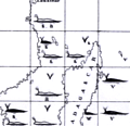 | Details | Maury, Matthew Fontaine | 1956 |
| Matthew Maury's Whale Chart Third Ed |
|
Maury, Matthew Fontaine |
|
| 1956 |
| LOC:68 |
| $1,900.00 | Maury--Matthew-Fontaine | Matthew-Maury-s-Whale-Chart-Third-Ed | Rare world-wide thematic chart of reported whale sightings by Matthew Fontaine Maury. Provides data on whale sightings by season, geographic area, whale species, and relative frequency. First published in 1851 but this 3rd edition re-issued in 1956 by the U. S. Navy Hydrographic Office.
<br><br>
Maury's Whale Chart provided valuable information about the migratory patterns of various whale species based on data collected from whalers and merchant ships and depicted the seasonal movements of different whale species in the Atlantic and Pacific Oceans. It included information about the regions where whales were most commonly found during specific times of the year, helping whalers optimize their efforts and increase their chances of successful hunts.
<br><br>
The last three editions of Maury's Whale Chart may be identified thus:
<div class="indenttextblocksingle">
<ul style="list-style-type: circle;">
<li><b>Third Edition (1956)</b></br>
Upper top left position with logo of eagle clutching items in claws surrounded by text: "Hydrographic Office U.S. Navy". Top right position is blank. Bottom right position reads "Price 20 cents / H.O. Miscel. No. 8514".</li>
<li><b>Fourth edition (1960)</b></br>
Upper top left position with logo of eagle over an anchor surrounded by text: "United States Hydrographical Office". Top right position reads "Catalog: Introduction. Part 1.". Bottom right position reads "Price 50 cents / H.O. Miscel. No. 8514" .
</li>
<li><b>Fifth edition (after 1972)</b></br>
Upper top left with logo containing an eagle perched on a globe with text "Defense Mapping Agency". Top right position reads "Catalog P2V10". Bottom right reads "Lith of Wm. Endicott & Co. N. York | 5018 | DMA Stock Number | W0XZC5018.</li>
</ul>
</div> |
| 6705 | 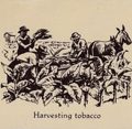 | Details | John Player and Sons | 1938 |
| Unrecorded thematic pictorial tobacco advertising map |
|
John Player and Sons |
|
| 1938 |
| LOC:40 |
| $1,000.00 | John-Player-and-Sons | Unrecorded-thematic-pictorial-tobacco-advertising-map | Fine unrecorded advertising world map "Tobacco" published by John Player and Sons (1) circa 1938 (2). The map shows graphically the sources where tobacco was grown as well as shipping routes for tobacco cargos to England. Inset tables for: the four methods of curing tobacco; and the United Kingdom's principal sources of supply of different types of tobacco. Sketches at top and bottom of the map show the various steps in the growth, shipment, and preparation of Player's various tobacco products including cigarettes.
<br><br>
Not found in WorldCat. No example or record of a sale of the Tobacco map is found online.
<br><br> |
| 6698 | 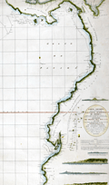 | Details | Direccion Hidrografia | 1800 |
| Rare Spanish chart of northwest South America exploration |
|
Direccion Hidrografia |
|
| 1800 |
| LOC:68 |
| $1,800.00 | Direccion-Hidrografia | Rare-Spanish-chart-of-northwest-South-America-exploration | A scarce, finely engraved original nautical chart of the northwest coast of South America from 1800. With the logo of the Deposito Hidrografico. Shows the tracks of Malaspina aboard the Descubierta and Atrevida (1). In the area of Ecuador the map is overlaid with the lines of the triangulation survey of La Condamine (2). Engraved by Fernando Selma. Dedicated to Don Antonio Cornel.
<br><br>
Shows the erupting volcano "Sangay" in Ecuador's eastern cordillera near to La Condamine's survey location.
<br><br>
(1) Malaspina Expedition - a voyage of scientific exploration sponsored by the Spanish government in the late 18th century. Led by Alejandro Malaspina the expedition set sail in 1789 with the aim of exploring and mapping the coasts of South America, Alaska, and the Philippines. The expedition included scientists, cartographers, and artists, and was one of the most extensive scientific expeditions of its time.
<br><br>
(2) Charles Marie de La Condamine was a French geographer, mathematician, and explorer who lived from 1701 to 1774. La Condamine conducted a triangulation survey near Quito, Ecuador and other locations during his expedition to South America. His goal was to measure the length of a degree of arc at the equator, which helped to confirm the shape of the Earth as an oblate spheroid. La Condamine also made important contributions to the study of Amazonian geography and culture, and he was one of the first Europeans to provide a detailed account of rubber. |
| 6687 | 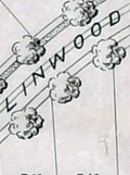 | Details | Olmsted, F. L. and Company | 1889 |
| F.L. Olmsted heliotype landscape plan Linwood Lynn Massachusetts |
|
Olmsted, F. L. and Company |
|
| 1889 |
| LOC:50 |
| $875.00 | Olmsted--F--L--and-Company | F-L--Olmsted-heliotype-landscape-plan-Linwood-Lynn-Massachusetts | Rare finely-detailed heliotype (1) plat and landscape plan by Frederick Law Olmsted for the Linwood development, in Lynn, Massachusetts, 1889. WorldCat lists only one copy, at Harvard. Heliotype Printing Co., Boston. R.R. Jones, del.
<br><br>
<div class="indenttextblocksingle">
"John Charles and Frederick Law Olmsted developed the Linwood subdivision on the estate of Philip Tapley, a hilltop property with views of striking features like Breed’s Pond and Lynn Harbor. With the site's steep topography, the pair faced challenges and had to make strategic design choices to maximize space on the hilltop plateaus. Plans show that roughly 218 lots were mapped to house large single-family homes. Unfortunately, Linwood was never developed (1).
<br>
</div>
<br>
In 1889, F. L. Olmsted designed Linwood, a neighborhood in Lynn, Massachusetts. The Linwood neighborhood was a unique project at the time, as it was one of the earliest examples of a planned suburban community. Olmsted was hired by the developers of the Linwood project, the Lynn Land Company, to design the landscape and street plan for the neighborhood. Olmsted's plan for Linwood included winding streets, spacious lots, and plenty of green space. He also designed a park in the center of the neighborhood, which he called "The Park at Linwood."
<br><br>
September, 1889. F. L. Olmstead & Co. Landscape Architects. Brookline, Mass. 1889. and Isaac K. Harris, Engineer. Lynn, Mass.
<br><br> |
| 6679 |  | Details | Glaubke, Bob | 1952 |
| Wild Bill Hickok Treasure Map pictorial thematic map |
|
Glaubke, Bob |
|
| 1952 |
| LOC:40 |
| $125.00 | Glaubke--Bob | Wild-Bill-Hickok-Treasure-Map-pictorial-thematic-map | 1950's pictorial thematic map, the "Wild Bill Hickok Treasure Map, of the United States, created by Bob Glaubke and published by Rand McNally in 1952. This map was a promotional item created by Rand McNally to advertise their line of maps and atlases.
<br><br>
The Wild Bill Hickok Treasure Map was a colorful and fanciful depiction of the American West, with illustrations of cowboys, Indians, and other Wild West icons. The map purported to show the locations of hidden treasures that were supposedly buried by the legendary gunslinger Wild Bill Hickok.
<br><br>
The Hickok map identifies numerous locations with some connection to mythical lost treasure including
<div class="indenttextblocksingle">
<ul style="list-style-type: circle;">
<li>Pensacola: Five large Spanish Treasure ships were wrecked...</li>
<li>Apalachicola: The pirate Billy Bowlegs ran his ship aground here...</li>
<li>Savannah: Th pirate John Hint is thought to have buried his treasure...</li>
<li>Murrell's Inlet: ...the pirate Murrell took shelter and buried treasure in the marshes here. </li>
</ul>
</div>
Wild Bill Hickok was a famous figure in the Old West, known for his prowess as a gunfighter and gambler. There are several legends surrounding him, including a supposed treasure map that he left behind. According to the legend, Hickok buried a treasure he won in a poker game, gold and other valuables, in the Black Hills of South Dakota before his death in 1876. He allegedly entrusted a treasure map to a friend, but the exact location of the treasure and the authenticity of the map are both widely disputed. |
| 6678 |  | Details | U.S. Coast Guard | 1972 |
| Coast Guard Poster worldwide locations |
|
U.S. Coast Guard |
|
| 1972 |
| LOC:86 |
| $145.00 | U-S--Coast-Guard | Coast-Guard-Poster-worldwide-locations | Decorative old-stock promotional poster ca. 1973 (1) with the locations of the U.S. Coast Guard around the world, or at least the western world. Executed with elements of 70's style reflecting the influence of the counter-culture on the arts during that period. With the Coast Guard motto : Semper Paratus or Always Ready.
The map omits any locations in Asia, where during that time period there was a war raging in Vietnam. Reminding the viewer of that overseas duty station was probably not conducive to the CG recruiting effort in '73.
<br><br>
Legend at bottom lists the activities and programs the U.S. Coast Guard engaged in including:
<div class="indenttextblocksingle">
<ul style="list-style-type: circle;">
<li>Icebreaking</li>
<li>Iceberg Patrol</li>
<li>Fisheries Conservation</li>
<li>Radio Navigation</li>
<li>Port Safety Vessel Traffic System</li>
<li>Search and Rescue</li>
<li>Aids to Navigation</li>
<li>Law Enforcement</li>
</ul>
</div>
(1) We have dated the map with reference to the planned Omega Station shown on the continent of Australia. Planning for that station was underway as early as 1972 when the Australian Department of Shipping and Transport was making a final site selection decision. The Omega Navigation System was a global radio navigation system that operated from 1971 to 1997. It consisted of eight ground-based stations, including three in Alaska, that transmitted signals in the VLF (Very Low Frequency) range to provide accurate navigation information for ships and aircraft. The Omega Navigation System was eventually replaced by more modern and precise satellite-based navigation systems such as GPS (Global Positioning System)
<br><br>
Document ID: G-PMR30 |
| 6669 |  | Details | Empire Tours Accociation | 1913 |
| 1915 Empire Tours map Native American Adirondack Iroquois and Onondaga Trails |
|
Empire Tours Accociation |
|
| 1913 |
| LOC:86 |
| $100.00 | Empire-Tours-Accociation | 1915-Empire-Tours-map-Native-American-Adirondack-Iroquois-and-Onondaga-Trails | Empire Tours thematic tours map issued by the Empire Tours Association in 1913. Map shows three colored auto-tourism routes in New York State: the Adirondack Trail, Iroquois Trail, and Onondaga Trail all routes associated with Native American tribes and. Numbers opposite the tour routes referred to corresponding route numbers in Volume 1 of the Automobile Blue Book.
<br><br>
Copyright Empire Tours Association. Compiled by Official Automobile Blue Book Publishing Company. Comprises eight panels of a 12-panel brochure.
<br><br>
Overall, the Empire Tours map issued by the Empire Tours Association in 1913 provides a fascinating glimpse into the early days of auto tourism in New York and the United States, and highlights the important role that organizations like the Empire Tours Association played in promoting travel and tourism in the region.
<br><br>
During the early 20th century, the advent of the automobile brought about a new era of travel and exploration, as more and more people began to hit the road in search of adventure and new experiences. To help these travelers navigate the often-unfamiliar territory they encountered on their journeys, publishers began producing auto tour road maps, which provided detailed information about road conditions, landmarks, and other useful information.
<br><br>
Circa 1910-1920, these road maps were an essential tool for any auto tourist, as they helped drivers plan their routes, find accommodations, and locate important sites and attractions along the way. Many of these maps were produced by established publishers, such as the Official Automobile Blue Book Publishing Company and Rand McNally, and featured colorful illustrations, detailed descriptions, and helpful tips for travelers.
<br><br> |
| 6620 | 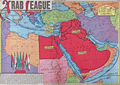 | Details | Sundberg, Edwin L. | 1946 |
| Colorful Scarce Coloroto Map Arab League Nations Middle East |
|
Sundberg, Edwin L. |
|
| 1946 |
| LOC:300 |
| $250.00 | Sundberg--Edwin-L- | Colorful-Scarce-Coloroto-Map-Arab-League-Nations-Middle-East | Colorful "Coloroto" rotogravure (1) map of the Middle East post WWII highlighting the Arab League member nations and prospective nations. Shows the seven nations that comprised the Arab League in July, 1946: Saudi Arabia, Egypt, Syria, Palestine, Iraq, Yemen, and Lebanon.
<br><br>
Formed March, 1945, the Arab League's purpose was "… draw closer the relations between member states and co-ordinate collaboration between them, to safeguard their independence and sovereignty, and to consider in a general way the affairs and interests of the Arab countries". (1)
<br><br>
(1) Coloroto is a trade name for a rotogravure used to print multiple colors. According to Google a rotogravure printing system uses a rotary press with <b>intaglio cylinders</b>, typically running at high speed and used for long print runs of magazines and stamps. (Google Oxford languages dictionary. Online).
<br>
<br>
(2) Pact of the League of Arab States, 22 March 1945. The Avalon Project. Yale Law School. 1998.
<br><br> |
| 6621 |  | Details | Sundberg, Edwin L. | 1946 |
| India Britains Problem Child Pictorial Coloroto map |
|
Sundberg, Edwin L. |
|
| 1946 |
| LOC:300 |
| $250.00 | Sundberg--Edwin-L- | India-Britains-Problem-Child-Pictorial-Coloroto-map | Post-WWII pictorial Coloroto (1) or color rotogravure map with India referred to a "Britain's Problem Child", reflecting Britain's colonial presence in India in July, 1946. A legend lists numerous exported products with icons for each including jute, coconut, manganese, copper, linseed, and rubber. Inset map at left shows trade routes from Britain to India via the Suez Canal with British colonies colored in red. Inset pictorial bar chart at right shows the comparative population for each religion in India.
<br><br>
(1) Coloroto is a trade name for a rotogravure used to print multiple colors. According to Google a rotogravure printing system uses a rotary press with <b>intaglio cylinders</b>, typically running at high speed and used for long print runs of magazines and stamps. (Google Oxford languages dictionary. Online).
<br><br> |
| 6622 |  | Details | Sundberg, Edwin L. | 1944 |
| Thematic Map of the World's population WWII era |
|
Sundberg, Edwin L. |
|
| 1944 |
| LOC:300 |
| $125.00 | Sundberg--Edwin-L- | Thematic-Map-of-the-World-s-population-WWII-era | WWII-era thematic Coloroto (1) or color rotogravure map by Edwin Sundberg presenting statistics on the relative population density of the world's nations in 1944.
<br><br>
(1) Coloroto is a trade name for a rotogravure used to print multiple colors. According to Google a rotogravure printing system uses a rotary press with <b>intaglio cylinders</b>, typically running at high speed and used for long print runs of magazines and stamps. (Google Oxford languages dictionary. Online).
<br><br> |
| 6618 |  | Details | Holm, Bill | 1965 |
| Old West style pictorial map of the Permian Basin Texas New Mexico |
|
Holm, Bill |
|
| 1965 |
| LOC:89 |
| $350.00 | Holm--Bill | Old-West-style-pictorial-map-of-the-Permian-Basin-Texas-New-Mexico | Original Old-West-style pictorial map of the Permian Basin, Texas and New Mexico, created by Bill Holm and copyrighted circa 1965. This scarce pictorial map was compiled by the Permian Basin Chamber of Commerce Tourist Committee and published by Holm and West Texas Office Supply. The map retains the graphic and illustrative character typical of promotional region maps from the mid-20th century and was originally issued as part of an eight-panel folding brochure titled Ride the Permian Basin, The Official Guide to the History Lands of the Southwest. <br><br>
The map is centered on Odessa, Texas, and extends across the Permian Basin region of West Texas and southeastern New Mexico. It shows towns, roads, highways, and trails, along with pictorial figures and symbols representing Native Americans, buffalo, cowboys, and topographic features such as mesas and escarpments. A legend at right includes historic and overland routes such as the California Trail, overland stage paths, and the Comanche war trail. Named locations include Big Spring, Fort Lancaster, Midland, Fort Stockton, the McDonald Observatory, Guadalupe Peak, Carlsberg Caverns State Park, the Llano Estacado, and Castle Gap. <br><br>
This pictorial map is of interest to collectors of Western Americana, historical travel ephemera, and regional cultural cartography due to its representation of mid-20th century tourism promotion and its depiction of historic routes and landmarks in the Permian Basin. The original brochure format and illustrative style reflect local efforts to interpret and market the history and geography of the American Southwest during the 1960s. |
| 6596 |  | Details | Brunswick Golden Isles Chamber of Commerce | 1963 |
| Treasure Map Brunswick and Golden Isles Georgia |
|
Brunswick Golden Isles Chamber of Commerce |
|
| 1963 |
| LOC:89 |
| $120.00 | Brunswick-Golden-Isles-Chamber-of-Commerce | Treasure-Map-Brunswick-and-Golden-Isles-Georgia | Ye Olde Treasure Map Brunswick and the Golden Isles of Georgia is a fact-filled pirate-themed pictorial map of Brunswick and the Golden Isles of Georgia. Includes Jekyll Island, Saint Simons Island, and Sea Island. At right, an inset large-scale context map of the United States East Coast.
<br><br>
Blackbeard says hoist your wallet and heave your doubloons on this one before she sails away. Arrgh! |
| 6585 | 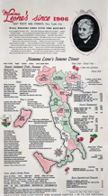 | Details | Mama Leone | 1960 |
| Large menu for Mama Leone's Restaurant in NYC |
|
Mama Leone |
|
| 1960 |
| LOC:57 |
| $225.00 | Mama-Leone | Large-menu-for-Mama-Leone-s-Restaurant-in-NYC | Large original menu from Mama Leone's restaurant in New York City circa 1960. Colorful pictorial map of Italy at center at center divided into administrative regions with each region promoting one or more of Mama Leone's wine offerings, for example Frecciarossa, Brachetto, Lambrusco, or Verdiccio or another of the available wines. Mama Leone's restaurant closed in 1994.
<br><br>
Inset photo of Mama Leone at top right. |
| 6584 | 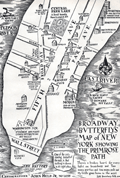 | Details | Held, John Jr. | 1931 |
| Pictorial Map of Lower Manhattan or Broadway Butterfly's Map |
|
Held, John Jr. |
|
| 1931 |
| LOC:89 |
| $200.00 | Held--John-Jr- | Pictorial-Map-of-Lower-Manhattan-or-Broadway-Butterfly-s-Map | John Held, Jr., (1889-1958) was a cartoonist, illustrator, printmaker and author. Held's cartoons satirized and epitomized the United States' “Jazz Age” of the 1920s. Here, Held's cartoon for "Broadway Butterflys" satirizes the fast life of the New York elite with its focus on Wall Street, Broadway, Fifth Avenue, and Park Avenue. Shows the Jefferson Market Night Court, now the Jefferson Market Branch of the New York Public Library and the morgue, "end of the Primrose Path." Presumably Held included the image to illustrate his story, “Broadway Butterfly,” in Held's second published collection of short stories, Dog Tales (1930).
<br><br>
Verso with an engraving by Held: "When the Theatre was Fraught with Romance."
<br><br>
Held was apparently a VERY popular cartoonist before the Depression. According to New York's Center Gallery: <div class="indenttextblocksingle">"He lived in the era of cartoonists as national heroes. In 1927, Vanity Fair named Held to its “Hall of Fame” alongside international luminaries of the decade. The Hearst newspapers paid him $250,000 a year (nearly $4,000,000 today, adjusted for inflation) for his cartoon strip, Oh! Margy, and his drawings sold for up to $5,000 each, roughly the price of a house." (1)
</div><br>
(1) Online. Retrieved December, 2022. https://www.centergallerynyc.org/exhibitions/johnheldjr |
| 6560 |  | Details | Hawkes, W. and Barber, J. | 1890 |
| Manuscript isodistance map of the New York City area after Hawkes and Barber |
|
Hawkes, W. and Barber, J. |
|
| 1890 |
| LOC:141 |
| $700.00 | Hawkes--W--and-Barber--J- | Manuscript-isodistance-map-of-the-New-York-City-area-after-Hawkes-and-Barber | Very unusual and one-of-a-kind manuscript traced map ca. 1890 (on tracing cloth) of the area around New York City- after Hawkes and Barber's "The Country twenty five miles round New York" (1777). Text below the map contains a list of important events during the U.S. Revolution in 1776. A key feature of the map is the early use of <b>isodistances</b>, concentric circles at increasing five-mile intervals centered on the city of New York.
<br><br>
This map represents an exceptional effort that likely took days for the anonymous creator to trace. Fine attention to detail and careful execution suggest that the copy was created for research purposes, or possibly for the purpose of producing blueprints from this master trace document. With a few manuscript notes at bottom right that suggest the trace was created from the copy of Hawkes and Barber's map held at the New York Public Library (1).
<br><br>
A fine gift for collectors of New York cartography or of rare cartographic oddities.
<br><br>
From an estate with three similar manuscript trace maps of foundational New York State maps by <a href="https://www.rarecharts.com/ShowDetail/Creator/de-Witt--Simeon/Title/Unusual-manuscript-trace-map-of-New-York-state-after-Simeon-de-Witt-1802/6559"" target="_blank"> Simeon de Witt </a> and David H. Burr. Riverine features in green ink, red ink for highways and roads, brown for political boundaries and for isodistances.
<br><br>
(1) Lionel Pincus and Princess Firyal Map Division, The New York Public Library. "The Country twenty five miles round New York" The New York Public Library Digital Collections. 1777-01-01. https://digitalcollections.nypl.org/items/510d47da-ee36-a3d9-e040-e00a18064a99 |
| 6517 |  | Details | Smiley, Russ | 1987 |
| Russ Smiley's Fishing Map South Florida Miami Fort Lauderdale Key West |
|
Smiley, Russ |
|
| 1987 |
| LOC:87 |
| $175.00 | Smiley--Russ | Russ-Smiley-s-Fishing-Map-South-Florida-Miami-Fort-Lauderdale-Key-West | Late 1980's decorative fishing chart of the Everglades, Miami, South Florida, and the Florida Keys surrounded by Smiley's illustrations of colorful fishes. This map is becoming increasingly scare on the market. The chart is overprinted with red dots representing hot fishing spots from Ft. Lauderdale to Key West and with the names of the fishes that might be caught in an area.
<br></br>
Created and published by Miami, Florida artist Russ Smiley, El Portal Florida. Last copyright is from 1987 by Windward Publishing.
<br></br>
Verso with illustrations of South Florida fishes, fishing techniques, and baits. |
| 6508 | 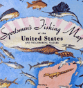 | Details | Moss, Ira | 1957 |
| Pictorial Sportsmen's Fishing Map United States and Neighboring Waters |
|
Moss, Ira |
|
| 1957 |
| LOC:141 |
| $275.00 | Moss--Ira | Pictorial-Sportsmen-s-Fishing-Map-United-States-and-Neighboring-Waters | Scarce original 1957 fisherman's map of the United States and Neighboring Waters designed by Ira Moss and produced by Barry, Moss, and Shore. Border is decorated with numerous images of fishing flies and saltwater fishing lures.
<br><br>
Saltwater fish, freshwater fish. Swordfish, bonefish, weakfish, flounder. Whitefish, bluefish, jewfish, croaker. No redfish but "channel bass" with a spot. Wahoo !
<br><br>
Includes small inset maps of the USA showing where a few specific species are most prevalent. Several inset tables: lists of saltwater fish, and freshwater fish; list of states and locations keyed to fish species,
<br><br>
Copyright 1957. Published by Shorewood Press, Fine Arts Publishers, New York. |
| 6501 | 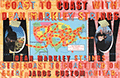 | Details | Anonymous | 2000 |
| Poster and map for Dean Markley Guitar Strings and Jaros Custom Guitars |
|
Anonymous |
|
| 2000 |
| LOC:78 |
| $150.00 | Anonymous | Poster-and-map-for-Dean-Markley-Guitar-Strings-and-Jaros-Custom-Guitars | Unrecorded poster related to a coast-to-coast tour by Jon Butcher and Bruce Gatewood promoting Dean Markley guitar strings and Jaros Custom Guitars ca. 2000. With an inset map of the tour across the United States including photos of Jon and Bruce.
<br><br>
Jaros Guitars was started by the father and son team of Harry and Jim Jaros of Mary Street, Rochester, Pennsylvania in 1996. Dean Markley has produced guitar strings since 1972.
<br><br>
An archived web page about Jaros Custom Guitars from 1999 tells the Jaros story:
<div class="indenttextblocksingle">
"The Jaros Guitar "factory" is a home-based, part-time operation located in the beautiful Pennsylvania countryside. Jim, his wife Patty, and their sons Jason (14), and Taylor (8), live only 100 yards from Jim's folks, Harry and Mary (and coincidentally, Harry's large well-equipped woodshop).The shop is a 30' x 40' pole-barn with 12' ceilings and three work bays." <br> (Dynamic Duo: This father-son team's a good combination. TradeSecrets. Vol. 25. Wayback Machine)
</div> |
| 6500 | 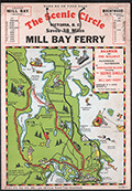 | Details | Page, Peter Hugh | 1936 |
| Rare pictorial map of Victoria, British Columbia with Ferry Routes |
|
Page, Peter Hugh |
|
| 1936 |
| LOC:78 |
| $350.00 | Page--Peter-Hugh | Rare-pictorial-map-of-Victoria--British-Columbia-with-Ferry-Routes | Rare pictorial auto map of Victoria, Vancouver Island, British Columbia, Canada featuring the Mill Bay Ferry route as an element of the Scenic Circle auto route. The map features numerous small cartoonish drawings of local activities including golfing, hunting, fishing, gardening, and horse racing. No holdings of this rare pictorial auto route map are found anywhere else online, nor any record of sales. Dated within to 1936.
<br><br>
Locations noted on the map include Telegraph Beach, Victoria Golf Club, James Island, Sidney, Sidney Island, Esquimalt Harbor, and Cordova Bay.
<br><br>
On card stock, this unusual piece of cartographic ephemera includes the original string hanger still attached through two punched holes.
<br><br>
Recto with departure times for the Mill Bay Ferry from both Malahat and from Brentwood. Verso with a photo of the ferry - M.S. Cascade, an inset smaller-scale sketch map of the Victoria surrounding area, a mileage table, and text on points of interest and suggestions for the Scenic Circle drive.
<div class="indenttextblocksingle">
"Ferry Trip across the placid waters of Saanich Arm, Sport Fishing preserve, where salmon up to 53-lbs. are taken and over fifty species of fish are found. From the Ferry can be seen Senanus Island, an ancient Indian burial ground, Bamberton Cement Works, Brentwood Cottage".
<br>and<br>
"A glance at the Map on the other side will convince you of the ease and simplicity of this Route. You can save MONEY, TIME and reduce your mileage from 83 to 45 by using this convenient connecting link [ferry] between Mr. BUTCHARTS GARNENS and the Famous MALAHAT DRIVE…"
</div> |
| 6455 |  | Details | White, Ruth Taylor | 1929 |
| Six early pictorial airline route maps by Ruth Taylor White |
|
White, Ruth Taylor |
|
| 1929 |
| LOC:14 |
| $1,200.00 | White--Ruth-Taylor | Six-early-pictorial-airline-route-maps-by-Ruth-Taylor-White | Rare and fine eleven-page brochure for Western Air Express published in 1929, just three and one-half years after the airline was founded. Includes six pictorial airline route maps or cartographs by famed illustrator Ruth Taylor White. </b> Maps with inset half-tone images of aircraft and flight operations.
<br><br>
The Western Air Express Corporation, later Western Airlines, began its first passenger service in 1926 touting speed, comfort, and dependability. By 1928, employing Fokker Super Tri-motor passenger aircraft capable of transporting twelve passengers at a blistering 125 MPH, the airline "carried about eighteen percent of all inter-city passengers in the United States." In 1928 the company initiated a seaplane route from Catalina Island, California to Los Angeles, California. Maps include:
<div class="indenttextblocksingle">
<ul style="list-style-type: circle;"></li>
<li><b>San Francisco - Los Angeles.</b> 365 miles, 3 hours. "The Worlds Model Air Line." Two facing sheets, each 7.5" x 8"</li>
<li><b>Los Angeles - Kansas City.</b> 1,417 miles - 12 hours. First and fastest all Daylight Passenger Airway." Two facing sheets each 7.5" x 8".</li>
<li><b>Los Angeles to Catalina.</b> 45 miles - 30 minutes. "Over land and sea. The first air passenger service in the United States. Single center-fold sheet 15" x 8".<br>
<b> Los Angeles to Tia Juana or Agua Caliente".</b> 116 miles - 1 hour. With above. </li>
<li><b>Los Angeles - Salt Lake City.</b> 600 miles - 6 hours. "Over the Old Mormon Trail". Two facing sheets each 7.5" x 8".</li>
<li>Map of the USA showing expected travel-time zones, indicated by color legend. No title. One half sheet.</li>
<li>B&W inset map showing location of the Western Air Express Terminal south of San Gabriel. No title.</li>
<li>Cover 8" x 9" showing all included passenger routes for Western Air Express.</li>
</ul>
</div>
Publication date noted within as October, 1929. Folds down to 4" x 9". |
| 6410 | 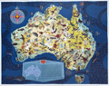 | Details | Santos, George | 1959 |
| Rare pictorial map of Australia with local fauna produced for Shell Oil Company |
|
Santos, George |
|
| 1959 |
| LOC:89 |
| $1,200.00 | Santos--George | Rare-pictorial-map-of-Australia-with-local-fauna-produced-for-Shell-Oil-Company | A very beautiful original 1959 lithographed pictorial map of Australia decorated profusely with drawings of Australian animals. Guaranteed original. Scarce on today's market.
<br><br>
Artwork by George Santos for the Shell Oil Company of Australia. Shell Oil Company logo at upper left.
<br><br>
Overall dimensions: 17.5 in. x 22.25 or 45 cm. x 57 cm.
<br><br>
Legend contains an inset key map and a list that denotes the names of the animals related numerically to positions on the key map.
<br><br>
Very rare. Only two institutional holdings are cataloged in WorldCat, both within Australia. |
| 6411 | 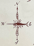 | Details | Overly, Charles H. | 1957 |
| 1st ed. Block Island Town of New Shoreham Rhode Island |
|
Overly, Charles H. |
|
| 1957 |
| LOC:89 |
| $450.00 | Overly--Charles-H- | 1st-ed--Block-Island-Town-of-New-Shoreham-Rhode-Island | Very nice original pictorial map of Block Island, Rhode Island lying in Block Island Sound by Charles H. Overly. First edition map printed in 1957. The map is printed on laid paper with a light brown tint throughout to simulate age.
<br><br>
Esta Gray operated a gift shop in Old Harbor, Block Island- Esta's Gifts of Distinction. In 1957 Esta commissioned Charles H. Overly to draw the map of Block Island to sell to tourists visiting her shop. This edition contains Esta' Grays 1957 copyright notice and a double decorative rope-work border.
<br><br>
Charles H. Overly (1908-1970) was a University of Vermont graduate and artist. Returning home after a long tour of Europe, Overly began the Charles H. Overly Studio in 1938. He is best known for sketches and paintings of New England historical landmarks. |
| 6402 |  | Details | Broms, Allan | 1934 |
| Broms Star Guide Planisphere |
|
Broms, Allan |
|
| 1934 |
| LOC:300 |
| $995.00 | Broms--Allan | Broms-Star-Guide-Planisphere | Broms Star Guide (1934), a very rare planisphere created during the depth of the Great Depression. This planisphere is the only example of Broms Star Guide known to exist (per Internet search). It contains much peripheral information about astronomy that are not found on other planispheres, e.g. moon phases, meteor calendar, the Greek alphabet, and a moon map.
<br><br>
Model AN, for the Northern Hemisphere. Published by the Graphex Company, New York.
<br><br>
This planisphere was created by Allan (Allen) Strong-Broms (1886-1965), draft resister, Leavenworth prisoner, author, inventor, lecturer, businessman and "not a professional astronomer". As a result of his pacifism and resistance Broms told his son that he “had seen the inside of twenty-two jails.” [2]
<br><br>
No copies located online and no holdings recorded in WorldCat. The only mention of Broms Star Guide is the LOC copyright catalog. Allan Broms was granted a patent for the Star Guide on November 20, 1934.
<br><br> |
| 5498 | 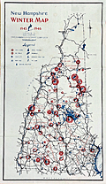 | Details | New Hampshire State Planning and Development Comm | 1945 |
| Ski Map or Poster for New Hampshire State |
|
New Hampshire State Planning and Development Comm |
|
| 1945 |
| LOC:150 |
| $275.00 | New-Hampshire-State-Planning-and-Development-Comm | Ski-Map-or-Poster-for-New-Hampshire-State | Decorative lithographed skiing map / poster of the State of New Hampshire published by the New Hampshire State Planning and Development Commission in 1945.
<br></br>
This medium-sized thematic pictorial poster of New Hampshire uses an unusual two-part icon design to signify locations in New Hampshire for skiing, snowmobiling (skimobile) and ice skating for these regions:
<div class="indenttextblocksingle">
<ul style="list-style-type: circle;">
<li>Monadnock Region</li>
<li>White Mountains Region</li>
<li>Dartmouth, Lake Sunapee Region</li>
<li>Lakes Region</li>
<li>Merrimack Region</li>
<li>Seacoast Region</li>
</ul>
</div>
The poster shows numerous, mostly small ski-areas, many no longer in operation including:<a href="http://www.nelsap.org/nh/epping.html" target="_blank">Epping Tow</a>, <a href="http://www.allroutes.to/berlin/skijump/" target="_blank">Nansen Ski Jump (Berlin, N.H.)</a>, and <a href="http://www.nelsap.org/nh/drummer.html" target="_blank">Drumalock Hill / Drummer Hill Tow (Keene, N.H.</a> and many more [1].
</br>
Recto contains text and statistics describing ski locations across the State of New Hampshire, organized alphabetically by town within region.
<br></br>
[1] New Hampshire's lost ski areas. Online. http://www.nelsap.org/nh/nh.html
<br></br>
[ NH ] |
| 5499 | 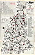 | Details | New Hampshire State Planning and Development Comm | 1935 |
| Scarce Map or Poster of New Hampshire Ski Trails |
|
New Hampshire State Planning and Development Comm |
|
| 1935 |
| LOC:150 |
| $365.00 | New-Hampshire-State-Planning-and-Development-Comm | Scarce-Map-or-Poster-of-New-Hampshire-Ski-Trails | Very scarce original lithographed skiing map / poster for the State of New Hampshire from 1935 when the state was the heart of skiing in the United States.
<div class="indenttextblocksingle">
"New Hampshire was the first place in America to have many things you see now at every ski resort. New Hampshire was the first to have trails cut just for downhill skiing. The Granite State was the first to have overhead wire-rope ski tows and an aerial tramway. Many famous races and styles of racing took place in New Hampshire. Professional ski patrols and ski schools began in New Hampshire. These new ideas, plus ski villages, started a whole new tourism industry." [1]
</div>
<br>
Inset tables of distances between cities, status (active/inactive) of airports during the winter season, and a list of approximately seventy member clubs of the U.S. Eastern Amateur Ski Association that included:
<div class="indenttextblocksingle">
<ul style="list-style-type: circle;">
<li>Appalachian Mountain Club. Boston, Mass.</li>
<li>Dartmouth Outing Club</li>
<li>Winnipesaukee Ski Club</li>
<li>Woodstock Ski Club</li>
<li>Nansen Ski Club</li>
<li>Lake Placid Ski Club</li>
</ul>
</div>
A rare record of club and commercial skiing in New Hampshire published by the New Hampshire State Planning and Development Commission in Concord, New Hampshire. Unlike another example of this ski map that we have in stock from a decade later in 1945, this map only lists individual ski trails, organized by region and very few of these trails have mechanical assistance to bring the skier up the mountain, such as tow ropes, chair lifts or trams (the first chairlift was built in New Hampshire. in 1937).
<br></br>
Verso contains text and statistics describing ski trails across the state. Copyright General Drafting Company, New York, N.Y.
<br></br>
[1] New Hampshire Ski History. Online. 2016. http://newenglandskimuseum.org/new-hampshire-ski-history-for-4th-graders/ |
| 5492 | 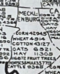 | Details | State and City Bank and Trust Richmond VA | 1922 |
| Map NC and SC with principal 1922 crop acreages |
|
State and City Bank and Trust Richmond VA |
|
| 1922 |
| LOC:10 |
| $295.00 | State-and-City-Bank-and-Trust-Richmond-VA | Map-NC-and-SC-with-principal-1922-crop-acreages | Thematic advertising map of North Carolina and of South Carolina with 1922 acreage statistics related to crops, livestock and other agricultural resources. Contains several inset tables of summary statistics:
<div class="indenttextblocksingle">
<ul style="list-style-type: circle;">
<li>Principal SC 1922 crop acreages (Cotton was #1 at nearly 2.2 million acres)</li>
<li>SC 1921 crop and sales value (Cotton #1 at $61M made up nearly half of SC crop output)</li>
<li>NC 1922 Crop acreages.</li>
<li>A marketing schedule for major agricultural crops and livestock: "When Carolina Crops are Marketed"</li>
</ul>
</div>
Lithographed. The maps are based on data provided by the U.S. Bureau of Markets and U.S. Bureau of Crop Estimates. A discreet call to action in inset text at far right: "You need some kind of banking service every day … Banking by Mail is one of our specialties … Our resources exceed $21,500,00." |
| 5472 | 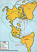 | Details | High Times | 1985 |
| Late 20th C map of International Drug Production |
|
High Times |
|
| 1985 |
| LOC:87 |
| $225.00 | High-Times | Late-20th-C-map-of-International-Drug-Production | Thematic, pictorial, world map focused on the agricultural and manufacturing/refining sites that produced illegal drugs in the mid 1980's. A two-page "Bonus Centerfold" to a 1985 issue of <i>High Times</i> a monthly drug-oriented, counterculture magazine published by Trans-High Corporation of Farmingdale, N.Y. Robert Aronson, publisher. Perfect for collectors, dispensary decoration, or nostalgic old hippies.
<br></br>
This fine, increasingly scarce, original map <strong>"The World According to Dope: A Guide to International Drug Production"</strong> shows locations for growing coca, pot, poppies, and khat as well as of laboratories for production of cocaine, heroin amphetamine, and more all explained in a legend near bottom center using simple easily-understood pictographs to represent each drug. Notations on the map supplement the location information with a few interesting tidbits, (e.g., "Ukrainian ditchweed", "Bahamas and Turks and Caicos Islands: one big money laundry".)
<br></br>
Verso with a single-page map <strong> "Guide to International Trade Routes" </strong>for heroin, marijuana, Quaaludes, Cocaine, and khat. Most destinations are located on the map in the United States or in Europe. Polar projection. |
| 5438 | 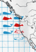 | Details | FAO United Nations | 1970 |
| Map of the world distribution of sperm and baleen whale catches |
|
FAO United Nations |
|
| 1970 |
| LOC:78 |
| $200.00 | FAO-United-Nations | Map-of-the-world-distribution-of-sperm-and-baleen-whale-catches | Scarce map of the number of catches of sperm whales and of baleen whales worldwide. From the "Atlas of the living resources of the seas" a publication of the Department of Fisheries for the <strong>Food and Agricultural Organization of the United Nations [1]</strong>.
<br><br>
Updating Maury one hundred years earlier, the color of whale pictographs are used to represent whale species. Location, and catch quantity also are represented on this chart of the world. Maury's chart reported whale sightings for sperm, baleen, and right whales, while this chart displays data on actual catches only of sperm and baleen whales.
<br></br>
[1] Online. Atlas of the living resources of the ses. United Nations FAO. http://www.fao.org/geonetwork/srv/en/metadata.show?id=9505&currTab=simple
<br></br>
(Atlas des resources biologiques des mers; Atlas de los recursos vivos del mar) |
| 5422 | 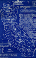 | Details | Douglas, Jack | 1948 |
| Rare blueprint prospectors map of California gold lodes |
|
Douglas, Jack |
|
| 1948 |
| LOC:90 |
| $550.00 | Douglas--Jack | Rare-blueprint-prospectors-map-of-California-gold-lodes | Very rare cyanotype (blueprint) self-published gold mining map of California by Jack Douglas (d. 1956)- "The Old Prospector's Lode Map of California." At a scale of one inch = 32 miles the map shows areas in California known to have produced gold, shown as shaded areas.
<br></br>
The map includes crude decorative images of gold panning equipment and of an old prospector at work. At bottom left a list of other gold lode district maps for sale at $1.00 each includes Alaska, Arizona, British Columbia, Idaho, Montana, Nevada, New Mexico, Oregon, Utah, Washington, and Wyoming. These could be purchased along with blueprint assembly instructions for mining equipment by Jack Douglas at Box 21, Dutch Flat, California.
<br></br>
No holdings found in WorldCat and no mention of the map is found online.
<br></br>
Text at right discusses gold mining in several California mining districts. Verso is blank. Map no. 153.
<br></br>
Jack Douglas was the founder of the United Prospectors Organization (1947), originally targeted at professionals who made their livelihood by prospecting and mining. Douglas published a journal- Panning Gold- the first issue of which was issued in 1947. United Prospector's was incorporated on November 29, 1949 with Jack Douglas as President. Other officers at the time of incorporation included Walter Robertson, Stockton, CA; Tylar Jack, Reedy, CA; Speed Freeman, Olympia Field, IL; Louis Borde, Eugene, OR; Harold Mitchell, Umatilla, OR; and Glen Houston, Lodi, CA. Today UPI is "the oldest gold, gems, and minerals prospecting group of its kind."
<br></br>
<div>
<img src="/ZoomifyImages/SC_5422/Doodle_Bug.jpg" alt="" width="200" align="left" style="margin: 0px 10px"/>
<span style="vertical-align: middle;">
Note: Price includes an additional rare blueprint (shown here) for Jack Douglas' "Doodle Bug" wet concentrator. Copyright 1944.
</span>
</div>
<br></br> |
| 5420 |  | Details | Maury, Matthew Fontaine | 1972 |
| Maurys Whale Chart 5th Edition |
|
Maury, Matthew Fontaine |
|
| 1972 |
| LOC:0 |
| $1,500.00 | Maury--Matthew-Fontaine | Maurys-Whale-Chart-5th-Edition | Scarce official U.S. thematic chart of reported whale sightings by geographic area, whale species, and relative number of sightings (5th ed. ca. 1972). An early example of the graphical display of quantitative information for decision making. The chart shows the best whaling areas and migration patterns for sperm whales and right whales, as well as the most densely populated areas of "Straggling" Sperm Whales and Right Whales." Chart # 5018.
<br></br>
Matthew Maury's Whale Chart, was first issued by the United States Bureau of Ordnance & Hydrography in 1851. This is the official U.S. fifth (5th.) edition, from the United States Defense Mapping Agency Hydrographic/Topographic Center in the 1970s. The DMA existed from 1972 through 1996. The first edition of Maury's Whale Chart is extremely rare on the market. Only one sale of Maury's chart is recorded in the Antique Map Price Record.
<br/></br/>
The last three editions of Maury's Whale Chart may be identified thus:
<div class="indenttextblocksingle">
<ul style="list-style-type: circle;">
<li><b>Third Edition (1956)</b></br>
Upper top left position with logo of eagle clutching items in claws surrounded by text: "Hydrographic Office U.S. Navy". Top right position is blank. Bottom right position reads "Price 20 cents / H.O. Miscel. No. 8514".</li>
<li><b>Fourth edition (1960)</b></br>
Upper top left position with logo of eagle over an anchor surrounded by text: "United States Hydrographical Office". Top right position reads "Catalog: Introduction. Part 1.". Bottom right position reads "Price 50 cents / H.O. Miscel. No. 8514" .
</li>
<li><b>Fifth edition (after 1972)</b></br>
Upper top left with logo containing an eagle perched on a globe with text "Defense Mapping Agency". Top right position reads "Catalog P2V10". Bottom right reads "Lith of Wm. Endicott & Co. N. York | 5018 | DMA Stock Number | W0XZC5018.</li>
</ul>
</div> |
| 5385 |  | Details | British Information Services | 1942 |
| Fine pictorial WWII-era map of the British Commonwealth of Nations |
|
British Information Services |
|
| 1942 |
| LOC: |
| $300.00 | British-Information-Services | Fine-pictorial-WWII-era-map-of-the-British-Commonwealth-of-Nations | Fine pictorial world map showing the British Commonwealth of Nations. Issued during WWII by the British Information Services, an agency of the British Government. Mercator projection.
<br></br>
Includes two inset tables:<br>
1) "Forms of Government". This key uses color to signify the form of government administration and management of internal and external affairs. <br>
2) "Principal Products". A tabular representation by geographical area uses pictograms to represent the most valuable products produced in the Commonwealth.
<br></br>
Distributed by the British Information Services, an agency of the British Government, 30 Rockefeller Plaza, New York. Printed in England. |
| 5381 | 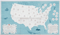 | Details | Smith Kline and French | 1962 |
| Thematic map of the USA allergy season by state |
|
Smith Kline and French |
|
| 1962 |
| LOC:88 |
| $220.00 | Smith-Kline-and-French | Thematic-map-of-the-USA-allergy-season-by-state | Decorative thematic advertising map of the continental United States showing the months during which three types of pollen are prevalent. The map, by Smith, Kline, and French Laboratories (SKF) was created to support sales of Teldrin Spansules, SKF's brand name for chlorpheniramine maleate, an antihistamine. This mid 20th-century map shows the pollen season for grass pollen, tree pollen, and ragweed pollen.
<br></br>
Philadelphia. October 1962. |
| 5364 |  | Details | Anonymous | 1909 |
| Pair of manuscript allegorical Maps of the Heart, anatomically correct. |
|
Anonymous |
|
| 1909 |
| LOC:13 |
| $1,100.00 | Anonymous | Pair-of-manuscript-allegorical-Maps-of-the-Heart--anatomically-correct- | Two rare <b>manuscript pen and ink</b> anatomically-correct heart-shaped geographical guides or allegorical maps: "Map of Man's Heart" and "Map of Woman's Heart". Both maps are attributed within circular cartouches reading "Surveyed and Drawn by HUB. Scale 2 miles = 1". 1909." This style of anatomical heart-shaped maps and some of the traits are not found anywhere online.
<br></br>
After similar Victorian-era maps by D.W. Kellogg & Co. of Connecticut ca. 1840. Unlike this manuscript pair of maps, the Kellogg lithographs were based on a stylized and exaggerated bi-lobed conception of the heart- the "Valentine" heart that we know today. Despite the differences in wording of traits, the theme of negative stereotypes for women is the same.
<br></br>
Map of Man's Heart includes large areas devoted to patience, modesty, fidelity (twice), benevolence, humanity, knowledge and love. On the other hand, the Map of Woman's Heart largely features conceit, jealousy, scandal, duplicity, deceit, fickleness and avarice among other traits. The woman's heart is pierced by the "River Tongue" and surrounded on one side by the "kleptomaniac ocean" and on the other side, the "cantankerous ocean".
<br></br>
Seller attributes the provenance to India "it came from a nurses friendship book, she being based in Bangalore India - her name was probably MacDonald." |
| 5346 |  | Details | Kellogg, Charles W. | 1960 |
| Pictorial Map of Seats on Talbot County Waterways |
|
Kellogg, Charles W. |
|
| 1960 |
| LOC:53 |
| $480.00 | Kellogg--Charles-W- | Pictorial-Map-of-Seats-on-Talbot-County-Waterways | Scarce pictorial thematic map with more than 80 historic estates (seats) near Chesapeake Bay in Talbot County, Maryland. Each estate is numbered and keyed to a list with the names of their owners. Small elevation drawings of each estate provide a rough idea of how the estate looked in 1960. The map includes some old historic points of interest in Talbot County such as the old Wye Church and Friends Meeting House.
<br></br>
The large waterways shown on this estate map include the Wye River, Miles River, Harris Creek, Broad Creek, Tred Avon River, and Choptank River. Smaller waterways include among others, Goldsborough Creek, Leeds Creek, Island Creek, and Trappe's Creek. Towns in Talbot County include St. Michaels, Easton, Oxford, Queen Anne, and Trappe.
<br></br>
Map Title: "Seats on Talbot County Waterways Chesapeake Bay." By Charles W. Kellogg. Updated edition from 1960 of a map that Kellogg first published in 1949. Charles Kellogg's own estate on Skipton Creek, numbered as #1 was "Langshaws".
<br></br>
Several of the seats listed in Talbot County in 1960 are found today in the National Register of Historic Places.
<div class="indenttextblocksingle">
<ul style="list-style-type: circle;">
<li>The Anchorage: Easton. Robert L. Kemp</li>
<li>Compton: Trappe. Charles F.C. Arensberg</li>
<li>Otwell: Oxford. J. E. Jackson</li>
<li>Troth's Fortune: Easton. Frederick S. Thomas</li>
<li>Wye House. Easton. Morgan B. Schiller</li>
</ul>
</div> |
| 5321 | 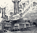 | Details | Price, R. M. | 1876 |
| Antique Map Of The South Mountain And Boston Rail Road and Connections |
|
Price, R. M. |
|
| 1876 |
| LOC:53 |
| $350.00 | Price--R--M- | Antique-Map-Of-The-South-Mountain-And-Boston-Rail-Road-and-Connections | Hand-colored, antique lithographed thematic map showing the route of the South Mountain and Boston Rail Road across the states of New York, New Jersey, Pennsylvania, and Massachusetts. Colored regions of the map are labeled with names of the metals, fossil fuels or other natural resources in the vicinity of the SM&BRR route. These resources include:
<div class="indenttextblocksingle">
<ul style="list-style-type: circle;">
<li>Coal</li>
<li>Bituminous Coal</li>
<li>Anthracite</li>
<li>Iron</li>
<li>Zinc</li>
<li>Petroleum</li>
<li>Lumber</li>
</ul>
</div>
Incorporated in 1854, the company suffered during the Panic of 1873 and began to auction off its property between 1877 and 1880. Includes a fine large decorative title vignette showing a puffing SM&BRR locomotive pulling passenger cars out of a dark tunnel.
<br></br>
The map was produced by R.M. Price Jr, Chief Engineer for the railroad. Published by Reading Publishing House in 1876.
<br></br>
Title: "Map Of The South Mountain And Boston Rail Road & Connections showing territory passed through rail-roads and canals crossed or connected with together with mineral and geographical features of country passed through."
<br></br>
Inset map of the SM&BRR bridge over the Hudson River: "Bridge by which the South Mountain & Boston R.R. is to cross the Hudson River at Poughkeepsie, N.Y. A short, direct railroad route from New England to the coal, oil, and slate regions of Pennsylvania and to the west and south."
<br></br>
Verso includes two Pennsylvanian township maps- Washington and Heidelburg townships. Neat pencil notation on verso: John Strauss, Mrs. Strauss |
| 5272 |  | Details | Bennett, Philip A. | 1949 |
| Earliest U.S. Government map television stations and networks |
|
Bennett, Philip A. |
|
| 1949 |
| LOC: |
| $1,250.00 | Bennett--Philip-A- | Earliest-U-S--Government-map-television-stations-and-networks | The earliest official large-format map of U.S. television stations and networks from the infancy of TV advertising. By U.S. Department of Commerce Industrial Economist Philip A. Bennet and printed by the U.S. Coast and Geodetic Survey in July, 1949. At the time of publication in 1949 the map clearly shows that numerous states were without a single operating TV station including: Nevada, Idaho, Montana, Colorado, Kansas, North Dakota, South Dakota, Nebraska, South Carolina, Vermont, New Hampshire, and Maine.
<br></br>
This map is scarce outside of institutional holdings. No copy of the map or record of the sale of this television map is found online. Price when issued 35 cents.
<br></br>
In January 1948, less than 200,000 TV sets existed in the U.S. This map documents the early distribution of broadcast TV stations, pre-dating the phenomenal growth of the industry. The map was and is important because the geographical distribution of TV stations impacted the size of the television market while TV networks served to lower the cost of content production.
<br></br>
Shows the 75 existing and 42 prospective analog broadcast television stations and <b>network routes</b> in the United States. Compiled and printed by the U.S. Coast and Geodetic Survey (Department of Commerce) to the specifications of Philip A. Bennet, General Products Division of the Office of Domestic Commerce.
<br></br>
See also Gould in NYT: https://timesmachine.nytimes.com/timesmachine/1949/04/24/93542916.html?pageNumber=299 |
| 5239 |  | Details | U.S. Army Engineers | 1878 |
| Early U.S. Flow Map Tonnage Chart of Coastwise Commerce |
|
U.S. Army Engineers |
|
| 1878 |
| LOC:3 |
| $320.00 | U-S--Army-Engineers | Early-U-S--Flow-Map-Tonnage-Chart-of-Coastwise-Commerce | Scarce thematic <b>flow map</b> of the United States west coast: California, Oregon, and Washington. An early institutional example of a "flow map" used for the U. S. Government. The flow map was first used less than 40 years earlier by Charles-Joseph Minard after his earlier formative use line width to display the attrition of French troops during Napoleon's Russian campaign of 1812.
<br></br>
<div class="indenttextblocksingle">
The chart shows the volume (tonnage) of maritime trade from all points south of San Francisco to ports along the U.S. West Coast. The use for the chart was to support the decision-making process for selecting a new harbor of refuge and breakwater on the Pacific Ocean between the Strait of Juan de Fuca and San Francisco.
<br></br>
Tonnage Chart of Coastwise Commerce North of San Francisco -California
<br></br>
From "Harbor of Refuge on the Pacific Coast Appendix PP of the Annual report to the Chief of Engineers for 1881. Washington: Government Printing Office. 1881. |
| 5190 | 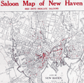 | Details | Anonymous | 1912 |
| Saloon Map of New Haven Connecticut |
|
Anonymous |
|
| 1912 |
| LOC:200 |
| $400.00 | Anonymous | Saloon-Map-of-New-Haven-Connecticut | Very scarce thematic map related to the temperance movement: "Saloon Map of New Haven, Connecticut" where red dots indicate the location of saloons within the city. Left side with statistics unfavorable to the consumption of alcohol which link alcohol to many of the ills besetting New Haven at the beginning of the twentieth century. For example:
<div class="indenttextblocksingle">
<ul style="list-style-type: circle;">
<li>One saloon to every 349 inhabitants.</li>
<li>42 percent of New Haven's arrests are for drunkenness.</li>
<li>44 percent of New Haven inmates of jail are there for drunkenness</li>
<li>60 percent of New Haven children in local public institutions in 1911 due to drunkenness of parents.</li>
</ul>
</div>
[ alcohol, temperance, prohibition, bar, pub, drinking, intoxication ] |
| 5173 | 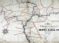 | Details | Wierman Jr., T. T. | 1876 |
| Map Showing the Canals Belonging to the Pennsylvania Canal Company. |
|
Wierman Jr., T. T. |
|
| 1876 |
| LOC:200 |
| $1,150.00 | Wierman-Jr---T--T- | Map-Showing-the-Canals-Belonging-to-the-Pennsylvania-Canal-Company- | Manuscript thematic surveyor's map from 1876 detailing the visible hydrographic features of east central Pennsylvania with numerous rivers, creeks and canals. The map's theme is the canals belonging to the Pennsylvania Canal Company.
<br></br>
The map was probably used to generate blueprint copies and dates to the beginning of the decline of the Pennsylvania Canal System. In 1867, the Pennsylvania Railroad formed the Pennsylvania Canal Company using their canals to haul freight. By 1900 most Pennsylvania canal were unused, a victim of the significant financial advantage provided by the railroads
<br></br>
With a finely drawn compass rose with a fleur de lis skewered by a gaily festooned pointer. Also contains much detail about railroads, bridges and towns, a reflection of the company's ownership by a railroad company.
<br></br>
Portions of the waterways are labeled as :
<div class="indenttextblocksingle">
West Branch Division
Juniata Division Penna Canal
Wyoming Division Pennsylvania Canal
Pennsylvania Canal
Union Canal
</div>
The map contains all or part of the following Pennsylvania counties: Blair, Center, Clynton, Huntingdon, Mifflin, Snyder, Juniata, Perry, Cumberland, York, Lancaster, Dauphin, Northumberland, Montou, Columbia, Luzerne, Lycom, Centre.
<br></br>
Drawn by T. T. Wierman Jr. Assistant Engineer. |
| 5145 | 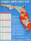 | Details | Kiplinger Washington Editors, Inc. | 1991 |
| Florida Population map for 1991 |
|
Kiplinger Washington Editors, Inc. |
|
| 1991 |
| LOC:87 |
| $100.00 | Kiplinger-Washington-Editors--Inc- | Florida-Population-map-for-1991 | Colorful, poster sized, Florida Population Map for 1991 produced for The Kiplinger Florida Letter. The map shows county forecasts for population growth in 1996 and 2001 in the State of Florida. Kiplinger forecast that the population of Florida would grow from 13.2 million to 16 million in 2001, a 21% increase. Kiplinger is a Washington, D.C.-based publisher of business forecasts and personal finance advice.
<br></br>
Includes four population tables and text. Price when issued was $5.00.
<br></br>
Clearly marked as "Not to be used for navigation." |
| 5035 | 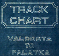 | Details | Georgia Southern and Florida Railway | 1916 |
| Track Chart Valdosta GA to Palatka FL for Georgia Southern and Florida Railway |
|
Georgia Southern and Florida Railway |
|
| 1916 |
| LOC:300 |
| $350.00 | Georgia-Southern-and-Florida-Railway | Track-Chart-Valdosta-GA-to-Palatka-FL-for-Georgia-Southern-and-Florida-Railway | Rare unrecorded cyanotype accordion-folded track chart or track profile (1916) for the <b>Georgia Southern and Florida Railway</b> over their Valdosta, Georgia to Palatka, Florida line. Measures more than 16 feet long. Railroad track charts are very rare and comprise an often-overlooked source for detailed geographic data that is unavailable elsewhere. Published January, 1916 with a MS note on the title page that the ballast is corrected to December 31, 1917.
<br></br>
The blueprint track chart was produced for internal use in the railway Engineering and Maintenance Office and thus may be the only copy remaining. Provides an unique source of detailed data for the railroad line which could be combined with existing cartographic data to enable father analysis.
<br></br>
Data includes railroad milepost numbers, track elevation, track grade, ballast composition (earth or cinders), track weight per linear yard, and geographical features. Notes features along the route including passenger stations, freight depots, water stations, coal stations, trestles, drains, culverts, and stock pens.
<br></br>
Please enquire for complete photographs of this 16' track chart. |
| 5026 |  | Details | Carr and McFadden, Inc. | 1927 |
| Map and Brochure for Palm Beach Regatta 1927 |
|
Carr and McFadden, Inc. |
|
| 1927 |
| LOC:87 |
| $365.00 | Carr-and-McFadden--Inc- | Map-and-Brochure-for-Palm-Beach-Regatta-1927 | Map (9" x 12") and booklet for the Washington's Birthday Regatta on Lake Worth. Palm Beach Yacht Club, 1927. Florida. Map shows the course of the Regatta races. Very scarce.
<br></br>
33 pages with advertisements, race rules, race history, and members of the Palm Beach Regatta Association.
<br></br>
Map drawn by Carr & McFadden, Inc. Civil Engineers in West Palm Beach Florida. |
| 5027 | 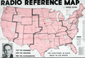 | Details | Wholesale Radio Laboratories | 1943 |
| Radio Reference Map of the United States |
|
Wholesale Radio Laboratories |
|
| 1943 |
| LOC:11111 |
| $400.00 | Wholesale-Radio-Laboratories | Radio-Reference-Map-of-the-United-States | Interesting, large WWII-era (1943) map of monitoring stations and the territory of the nine radio call-sign zones that existed in the United States during that time. At bottom, the map is filled with four inset maps of the USA showing locations of broadcast stations for the chief networks of the period: The Blue Network, Mutual Broadcasting System, Columbia Broadcasting System (CBS), and National Broadcasting Company (NBC). Includes tables of radio-related data: List of Standard (AM) Broadcast Stations, World Leading Shortwave Stations, and Experimental Frequency Modulation (FM) Stations.
<br><br>
Published for Wholesale Radio Laboratories, by Omaha native Leo Meyerson (d. 2011) during WWII. Meyerson founded Wholesale Radio Laboratories in Council Bluffs, Iowa in 1935, later renamed 'World Radio Labs' after WWII, 'WRL Manufacturing' in 1953 and to 'Globe Electronics' in 1958 The company became one of the world's largest manufacturers and distributors of amateur radio equipment.
<br><br>
During WWII all amateur radio stations were forbidden to transmit, although shortwave listening was still permitted. After the war amateur radio broadcasts were permitted by the government. This probably explains why a slightly older post-war edition of this map from 1947, in the Rumsey Map Collection prominently features a photograph of Myerson in his very impressive radio 'shack' where the earlier edition does not.
<br><br>
Another interesting difference between the two editions is that here Meyerson's amateur call sign, or unique identifier, is W9GFQ, where in Rumsey's 1947 edition his call sign is W0GFQ. The system of amateur radio call districts in the United States originally started with nine districts. This changed to ten districts in 1947. The 10th call district, '0', was added to accommodate the increasing number of amateur radio operators in the Midwest, especially in the Chicago area. |
| 1457 |  | Details | Gold, Joyce | 1804 |
| Chart of the Supposed Course of the Florida Stream |
|
Gold, Joyce |
|
| 1804 |
| LOC:3 |
| $400.00 | Gold--Joyce | Chart-of-the-Supposed-Course-of-the-Florida-Stream | Graphically arresting thematic chart of the "Florida Stream" or Gulf Stream with its flow northwards up the east coast of the United States, well past Bermuda, and then into the North Atlantic Ocean. Direction of the Gulf Stream current is shown visually by arrows supplemented with written notations indicating the compass direction at several locations across the stream.
<br></br>
The map may be considered to be an example of persuasive cartography. The concept of the Gulf Stream was novel at that time (hence the "supposed"); many mariners had not fully adopted the notion when this map was published. The direction and flow of the Gulf Stream was proposed by Benjamin Franklin in 1770 based on measurements he took during voyages from the U.S. to England and France.
<br></br>
London Published May 31, 1804 by J. Gold, 103 Shoe Lane. |
| 835 |  | Details | Dupain Triel, Jean-Louis | 1781 |
| Antique thematic map of French rivers and canals |
|
Dupain Triel, Jean-Louis |
|
| 1781 |
| LOC:0 |
| $3,000.00 | Dupain-Triel--Jean-Louis | Antique-thematic-map-of-French-rivers-and-canals | A large and rare antique thematic map of the rivers, streams, and canals of France with a very fine decorative cartouche. First and only edition. In two un-joined sheets. 36" W x 37" H when joined. Very decorative title cartouche with illustration of a late 18th century river barge with a large rudder; the size probably was necessitated by a small turning angle limited to the width of the barge cabin just aft of amidships. Possibly influenced by Sanson's 1641 "Carte des rivières de la France, curieusement recherchée" but Dupain-Triel's waterways map is much larger and contains greater detail.
<br></br>
Une grande et rare carte thématique antique des rivières, ruisseaux et canaux de France avec un très beau cartouche décoratif. Première et unique édition. Dans deux feuilles non jointes. 36 "L x 37" H une fois joint. Cartouche titre très décorative avec illustration d'une barge fluviale. Peut-être influencé par 1641 "Carte des rivières de la France de Sanson, curieusement recherchée" mais la carte des cours d'eau Dupain-Triel est beaucoup plus grande et contient plus de détails.
<br></br>
Both sheets of a 2 sheet map (not joined) of France by J.L. Dupain-Triel Sr. Rare, only one holding listed in OCLC/World Cat. Only two sales recorded in the AMPR.
<br></br>
In 1782 Dupain-Triel paid for the typesetting and engraving of a manuscript by Marcellin du Carla that proposed the use of contour lines as a means of adding elevation information to terrestrial maps and Dupain-Triel Sr. is distinguished as the maker of the first contour map of France in 1791, based on du Carla's method. This thematic map is noteworthy in that it does not contain any contour information although it is clear that when the map was published Dupain Triel Sr. had strong interest in the topic. (Konvitz, Joseph. "Cartography in France, 1660-1848: Science, Engineering, and Statecraft". University of Chicago Press. 1987. pp. 76-80.) |
| 568 |  | Details | Ponce, Nicolas. and Godefroy, Francois. | 1784 |
| Époques de l'établissement des Européens dans les États Unis |
|
Ponce, Nicolas. and Godefroy, Francois. |
|
| 1784 |
| LOC:3 |
| $375.00 | Ponce--Nicolas--and-Godefroy--Francois- | Époques-de-l-établissement-des-Européens-dans-les-États-Unis | One of the earliest available United States post-Revolutionary War population thematic maps, ca. 1784. Tabulates the population of the U.S. by state/territory. <br></br>
Shaded geographic areas on this original antique map show the Northeast United States and the extent of the original territories of Georgia, South Carolina, and North Carolina west to the Mississippi River. The shaded areas are tied back to a population table at left that shows the population for each territory. States and territories at the time of publication totaled a meager 3,119,676 persons, just 1% of the total population in 2013. This tabulation pre-dates the first official census that was conducted in 1790. In that earliest census the population was estimated at 3.92 million.<br></br>
At right the major ports for each state are identified and at bottom the authors provide a brief history for each state. All area west of the Mississippi River is labeled "Louisiane".<br></br>
French map published in Paris c. 1784. Source: "Collection d'estampes représentant les évenemens de la guerre, pour la liberté de l'Amérique Septentrionale". |