| | Thumbnail | | Creator | Date | Title / Author / Date / Location | Price | | | Description |
| 1353 | 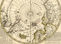 | Details | Moll, Herman | 1736 |
| Original Antique Polar Map of the North Pole |
|
Moll, Herman |
|
| 1736 |
| LOC:1 |
| $425.00 | Moll--Herman | Original-Antique-Polar-Map-of-the-North-Pole | Fine original antique 18th-century polar map of the <b>North Pole</b> annotated with observations and facts regarding early exploration of the north polar region. This striking polar projection shows Iceland, Greenland, Spitsbergen, Nova Zembla, portions of North America and Northern Europe. Text blocks at right and left detail the sun's movement at high latitudes and the explorations of the polar region by Frobisher, Davis and others
<br></br>
Printed for Tho: Bowles next ye Chapter House in St. Pauls Church Yard, & John Bowles at the Black Horse in Cornhill, London. |
| 5209 |  | Details | Moll, Herman | 1744 |
| Map of the North Pole by Herman Moll 1744 |
|
Moll, Herman |
|
| 1744 |
| LOC:13 |
| $325.00 | Moll--Herman | Map-of-the-North-Pole-by-Herman-Moll-1744 | Fine original antique 18th-century polar map of the North Pole by Herman Moll. This scarce map is annotated with observations and facts regarding early exploration of the north polar region. Perhaps this is an unrecorded fifth state of the map as the "Vol 1. p. 714" found at upper left in the fourth state has been largely effaced and only a faint hint of the graved lines remain visible. The number " 2 " at upper right is clearly visible.
<br></br>
This striking polar projection shows Iceland, Greenland, Spitsbergen, Nova Zembla, portions of North America and Northern Europe. Text blocks at right and left detail the sun's movement at high latitudes and the explorations of the polar region by Frobisher, Davis and others
<br></br>
Published in London in "Thomas Salmon's Modern History: or the Present State of All Nations." Printed for Tho: Bowles next the Chapter House in St. Pauls Church Yard, & John Bowles at the Black Horse in Cornhill, London. |
| 1308 | 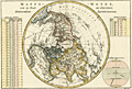 | Details | Bonne, Rigobert | 1787 |
| Antique Northern Polar Projection |
|
Bonne, Rigobert |
|
| 1787 |
| LOC:0 |
| $0.00 | Bonne--Rigobert | Antique-Northern-Polar-Projection | SOLD
<br><br/>
Early antique North polar projection covering the Northern Hemisphere from the North Pole to the Equator. |
| 1413 | 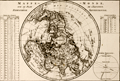 | Details | Bonne, Rigobert | 1787 |
| Antique Northern Polar Projection or Hemisphere Septentrional |
|
Bonne, Rigobert |
|
| 1787 |
| LOC:9 |
| $180.00 | Bonne--Rigobert | Antique-Northern-Polar-Projection-or-Hemisphere-Septentrional | Attractive North polar projection covering the Northern Hemisphere or "Hemisphere Septentrional" from the North Pole to the Equator. Early French copper-plate engraved map produced by Rigobert Bonne and crisply and finely engraved by Andre' to include mountain ranges and numerous place names. Surrounded by two tables of climatological data and a view of the "Sphere Parallele." Published in Paris in 1787. Plate 22.
<br></br>
Rigobert Bonne (1727-1794) was the successor to Jacques Nicolas Bellin as Royal Cartographer to France in the office of the Hydrographer at the Depôt de la Marine. Bonne first came to prominence when he published a number of charts in the Atlas Maritime in 1762, but Bonne is better known for later publications, including the Atlas Encyclopedique, which he collaborated on with Nicholas Desmarest, as well as the maps he produced for Raynal's Atlas de Toutes Les Parties Connues du Globe Terrestre. |
| 6712 |  | Details | Red Mountain Tribe | 1970 |
| Terrorism 1970's style |
|
Red Mountain Tribe |
|
| 1970 |
| LOC:86 |
| $200.00 | Red-Mountain-Tribe | Terrorism-1970-s-style | This is a title page to a 1970 issue of the Berkely Tribe newspaper- an anthropomorphized earth scowling with locations noted across his face that were the scene of left-inspired bombings, fire bombings, pipeline attacks, the odd embassy siege, and riots. Published in 1970, during the Vietnam war by the Red Mountain Tribe (1) with parallels to the tensions experienced today by the other side of the aisle.
<br><br>
The use of symbols as propaganda was a common tactic among activists during this time, and the Earth was a particularly powerful symbol of the counterculture's environmentalism and concern for the planet. By depicting the Earth as an old man with a scowl, the artist was likely attempting to convey a sense of anger and frustration at the destruction caused by the war and other government policies. The Earth's face being marked with locations that were the scene of attacks further reinforced the counterculture's proposition that the US government was engaging in destructive and unjust actions.
<br><br>
<div id="0" align="center">
<a title="Berkeley Tribe 1970"></a>
<img id="3" src="/ZoomifyImages/SC_6712/SC_6712_detail.jpg" alt="Anthropomorphized view of earth scowling with locations noted across his face that were the scene of left-inspired terror attacks." width="340"/> <br><small>... What's the world coming to?</small>
</div><br>
Berkely Tribe. 1970. Vol. 2 No. 8 Issue 34. Feb. 27 - Mar.6, 1970.
<br><br> |