| | Thumbnail | | Creator | Date | Title / Author / Date / Location | Price | | | Description |
| 1200 | 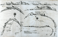 | Details | Thevenot, Melchisedech | 1663 |
| Rare chart of Table Bay and the Bay of Saldagne |
|
Thevenot, Melchisedech |
|
| 1663 |
| LOC:0 |
| $0.00 | Thevenot--Melchisedech | Rare-chart-of-Table-Bay-and-the-Bay-of-Saldagne | SOLD<br></br>
Very scarce mid 17th-century antique copper engraving including 6 coastal elevation views of anchorages and bays favored by Dutch and French vessels on their way to Asia.
<br></br>
These views include:<br></br>
Two views of the coast of Sierra Leone, Africa "Tagrin" opposite Freetown-
<div class="indenttextblock">
<ul style="list-style-type: circle;">
<li> "Carte de Serlionne, ou Tagrin a vue lieue et demie d'elle"</li>
<li>Quatriesme ance de la coste ancreage ordinaire de François. </li>
</ul>
</div>
A view of the coast of Aceh on the northern coast of Sumatra and a further unidentified anchorage "Baye de l'Encau".
<div class="indenttextblock">
<ul style="list-style-type: circle;">
<li>Poulo clauis</li>
</ul>
</div>
A view of the African coast including the Bay of Saldagne and Table Bay.
<div class="indenttextblock">
<ul style="list-style-type: circle;">
<li>Figure de la Terre de Saldagne</li>
</ul>
</div>
A coastal view at Tiku in West Sumatra. <div class="indenttextblock">
<ul style="list-style-type: circle;">
<li>Figure de la Rade de Ticou en l-isle de Sumatra <br />
(Identifies the two mountains of Pagaman and Priaman with Ticou nestled below. Interesting descriptions of 7 points on the view include "Illets a pigouins de table bay"- An island with penguins.)</li>
</ul>
</div>
This creaky old chart truly reflects its likely origins in the commercial world, perhaps first published privately by the VOC. The charts are characterized by a scarcely used 360 degree birds-eye oblique coastal view.
<br></br>
Melchisédech (or Melchisédec) Thévenot (c. 1620 – 1692) was a French author, scientist, traveler, and cartographer. Thévenot was the inventor of the spirit level and is also famous for his popular 1696 book- The Art of Swimming.
<br></br>
Many of Thévenot's maps were published in his Relations de Divers Voyages Curieux (Paris, 1663), a collection of translations of voyages of discovery. |
| 938 | 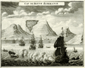 | Details | Chatelain, Henry | 1720 |
| View of Table Bay and Cape Town South Africa |
|
Chatelain, Henry |
|
| 1720 |
| LOC:6 |
| $295.00 | Chatelain--Henry | View-of-Table-Bay-and-Cape-Town-South-Africa | Attractive antique copper-plate engraving of Table Bay and early <b>Cape Town, South Africa</b>, about 40 miles north of the Cape of Good Hope. This very decorative view shows the nascent town of Cape Town with the Dutch Fort in the background and numerous ships at anchor in the foreground. In the far distance are Table Mountain and Devil's Peak. Table Bay was an important stop for resupplying ships making the passage to and from Europe and the East Indies.
<br></br>
With a textual description, in French, of the environs including that of nearby gardens and a small guest house or "Pavillon" of the <b>Dutch East India Company</b> near the garden. It was in that small guest house that a French embassy to Siam including six Jesuit priests set up an observatory during their stay in 1685. At bottom of the text is a engraved depiction of the guest house and gardens at night with a clock and telescope deployed to make astronomical observations; the Dutch fort visible in the background.
<br></br>
By Henri Chatelain, published in his <b>"Atlas Historique"</b> between 1705 and 1720.
<br></br>
Total size of page is 8" x 15"; the upper engraving of Table Bay and Mountain is 8" x 6". Book 6. No 17. Page 74. |
| 4843 | 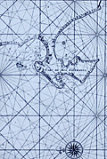 | Details | Valentijn, Francois | 1726 |
| Antique Dutch Chart of the Environs of Cape Town South Africa |
|
Valentijn, Francois |
|
| 1726 |
| LOC:9 |
| $825.00 | Valentijn--Francois | Antique-Dutch-Chart-of-the-Environs-of-Cape-Town-South-Africa | For collectors. Very old, scarce chart of the South African west coast from the Bay of Saldanha including Table Bay (Taefel Bay), False Bay, and Sout Bay all surrounding the Cabo de Boa Esperanca or Cape of Good Hope now the location of Cape Town, South Africa. By Dutch minister Francois Valentijn (Valentyn).
<br></br>
Only two sales recorded in the AMPR, none in the last 15 years. #43.
<br></br>
From Francois Valentijn's labor of seven years, the <b>Oud en Nieuw Oost-Indië</b>, considered the best source for reference material related to Asia for a period of almost two hundred years. |
| 5279 | 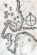 | Details | Bougard, Rene | 1785 |
| Rare woodcut chart Table Bay Saldanha Bay South Africa |
|
Bougard, Rene |
|
| 1785 |
| LOC: |
| $350.00 | Bougard--Rene | Rare-woodcut-chart-Table-Bay-Saldanha-Bay-South-Africa | Two scarce 18th-century woodcut harbor charts for South Africa on a single sheet. This fine antique harbor chart covers Table Bay, near Cape Town, South Africa and the Cape of Good Hope (Cap de Bonne Esperance). Verso contains another woodcut harbor chart of the Bay of Saldanha, on Africa's west coast about 70 statute miles northwest of Cape Town.
<br><br/>
From the atlas "Petit Flambeau de la Mer", published in more than 12 editions beginning in 1683 [1785] from le Havre, France by Rene Bougard. Printed area measures 4" x 6" on a larger sheet of laid paper. On the title page Bougard is listed as a Lieutenant of France's Vaisseau du Roi or the French sailing navy. The French navy was headquartered in Toulon while the French galley corps was at that time considered a separate entity and was based mainly at Marseille, France. French text.
<br><br/>
Copies of Bougard's harbor charts are rare and seldom found available for sale.
<br><br/>
Full title of Bougard's atlas is: "Le Petit Flambeau de la mer ou le veritable guide des pilotes cotiers ; Où il est clairement enseigné la maniere de naviguer le long de toutes les Cotes de France, d’Angleterre, d’Irlande, d’Espagne, de Portugal, d’Italie, de Sicile, de Malte, de Corse & de Sardaigne, & autres isles du Detroit; & des Cotes de Barbarie . . . " |
| 3689 | 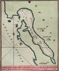 | Details | Luffman, John | 1800 |
| Antique map of Saldanha Bay, South Africa engraved for Luffman's Select Plans |
|
Luffman, John |
|
| 1800 |
| LOC:77 |
| $230.00 | Luffman--John | Antique-map-of--Saldanha-Bay--South-Africa-engraved-for-Luffman-s-Select-Plans | Fine copper-plate engraved plan of Saldanha Bay, South Africa, an important port north of Cape Town. As described by Luffman: <div class="indenttextblock">
"Saldanha Bay, An excellent harbour of Africa fourteen leagues north of Table Bay. In this Bay Lord Keith Captur'd a Dutch squadron under Admiral Lucas. Aug 17, 1796. Lat 33.30 S Longitude 18.20 E of London."
</div>
</BR>
Named after the early 16th-century Portuguese navigator António de Saldanha, the bay is both larger and safer than Table Bay, which is located 65 miles (105 km) farther south-southeast. Saldanha Bay’s former abundance of seals, fish, and guano deposits was long contested between French, English, and Dutch interests, with exploitation restricted only by a lack of fresh water in the area. (Encyclopaedia Britannica Online).
<br></br>
From "Luffman's Select Plans of the Principal Cities, Harbors, Forts etc. in the World". Engraved and published by John Luffman, No. 28 Little Bell Alley, Coleman Street. London. May 1, 1801. Volume II, Number 9.
<br></br>
Luffman also provided similar engravings to this at about the same time for J.T. Serres' "The Little Sea Torch: or, True Guide for Coasting Pilots." Serres translated the Little Sea Torch from an earlier illustrated coasting pilot guide, based on Bougard's "Le petit flambeau de la mer", first published in 1684.
<br></br>
John Luffman (1751-1821) began his career as an engraver, producing a very large and fine map of Antigua, where he had resided in 1787 and 1789. That map was published by Luffman to accompany his 'A Brief Account of the Island of Antigua', 1788." Luffman shared the same sad fate as many publishers and was declared bankrupt on 9th March, 1793. Moving forward Luffman was more cautious and produced small format atlases and handy-sized maps of the theatres of war, principal towns and cities and battle-plans relating to the Wars of the French directorate and the subsequent Napoleonic War. |
| 1304 | 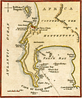 | Details | Naval Chronicle | 1812 |
| Cape of Good Hope with Table Bay and Cape Town. |
|
Naval Chronicle |
|
| 1812 |
| LOC:6 |
| $195.00 | Naval-Chronicle | Cape-of-Good-Hope-with-Table-Bay-and-Cape-Town- | Small attractive antique harbor chart near Cape Town, South Africa showing coastal mountains as well as False Bay and Table Bay. This neat copper-plated engraved antique nautical chart includes the following named features: Penguin Island, Sugar Loaf Hill or the Lion's Head, Lion's Rump, Chapman's or Hout Bay, Simon's Bay, Pringle Bay, Gordons Bay and Cape Hanglip.
<br></br>
Despite its small size the chart has an interesting history. The plate used to create this example was engraved and published by John Luffman in 1801 for Luffman's "Select Plans of the principal cities Ports, Harbours, Forts, etc. in the World". One can see the remnants of Luffman' original imprint mostly erased just below "Cape of Good Hope".
<br></br>
The hydrography includes anchorages, depth soundings, a "best track" into Simons Bay, numerous named rocks in False Bay including Romans Rock, Warren Hastings Rock, Francis Rock, Whittle Rock, and Anvil Rock.
<br></br>
Publisher's imprint at bottom reads: "Published December 31, 1812 by J. Gold. Naval Chronicle Office,103, Show Lane, London." |
| 797 | 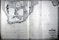 | Details | Robiquet, Aime | 1854 |
| Antique chart of Table Bay, False Bay and Cape Town, South Africa |
|
Robiquet, Aime |
|
| 1854 |
| LOC:0 |
| $1,250.00 | Robiquet--Aime | Antique-chart-of-Table-Bay--False-Bay-and-Cape-Town--South-Africa | Very special antique nautical chart of the southern-most portion of the African continent and southern Madagascar below 23 degrees south latitude. Carries Robiquet's blind stamp at bottom and also a blue over-stamp of the seller: Antoine Roux Fils of Marseilles, France. The Roux family had a long history as chart-makers, chart-sellers and nautical artists in Marseilles extending well over 100 years.
<br></br>
This large, French, steel-plate navigational chart of South Africa includes Angra Pequena, Saint Helena Bay, Cape Town ("Captown"), the Cape of Good Hope ("Cap du Bonne Esperance") , Cape Infanta, Cape St. Francis, Cape St. Lucia, and Cape Correntes, Mozambique and a large portion of the southern Indian Ocean.
<br></br>
Includes inset plans of False Bay and Table Bay; Port Natal; Delagoa Bay; Cape Agulhas ("Cap de Aguilles"); and Dyer Island and Point Danger.
<br></br>
This large nautical chart was published privately by hydrographer Aime Robiquet in the 'Atlas Hydrographique', one of 75 charts published in that atlas in 1856. Rue Pavée Saint-André des Artes No. 2, Paris, France. Printed by Louis Antoine, Rue de Noyers, 70. Price when issued was four francs. Number 44.
<br></br> |
| 4749 | 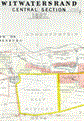 | Details | Consolidated Gold Fields of South Africa | 1897 |
| Scarce map of Witwatersrand gold fields south of Johannesburg, South Africa |
|
Consolidated Gold Fields of South Africa |
|
| 1897 |
| LOC:54 |
| $2,200.00 | Consolidated-Gold-Fields-of-South-Africa | Scarce-map-of-Witwatersrand-gold-fields-south-of-Johannesburg--South-Africa | Very rare sales broadside of the <b>Witwatersrand gold fields of Johannesburg</b> held by Gold Fields of South Africa, <b>South Africa's first mining house</b>, now <b>Gold Fields</b>. After the Witwatersrand gold rush in 1886 Consolidated Gold Fields was rated in 1897 as the most valuable company in the world, no doubt due in large part to the valuable assets detailed in this sales advertisement (1).
<br></br>
That company was formed in 1887, during the Witwatersrand gold rush, by Cecil Rhodes and Charles Rudd to hold properties they had acquired on the Transvaal's Witwatersrand gold fields. Reorganized as Consolidated Gold Fields of South Africa (Consgold) in 1892, this map from 1897 details the company's holdings near Johannesburg, SA.
<br></br>
Cecil John Rhodes was a British mining magnate from southern Africa who served as Prime Minister of the Cape Colony from 1890 to 1896 and was the founder of <b>De Beers</b> diamond company.
<br></br>
Rare. No copy of this map is found online or in the AMPR. Printed by Waterlow and Sons Limited, London. Map of the "Central Section" implies that this example would have been flanked by similar maps forming the west and east sections
<br></br>
The Witwatersrand is a 34 mi, north-facing ridge in South Africa. It consists of a hard rock, over which flow several waterfalls. In Afrikaans Witwatersrand, means "ridge of white waters".
<br></br>
(1) Bottom of the map contains a Schedule of Values of unworked reef claims at market prices on September 30, 1897. |
| 5307 |  | Details | Gobiet, Arthur | 1904 |
| Plan of the Industrial Exhibition in Cape Town during 1904 |
|
Gobiet, Arthur |
|
| 1904 |
| LOC:9 |
| $325.00 | Gobiet--Arthur | Plan-of-the-Industrial-Exhibition-in-Cape-Town-during-1904 | Plan of part of the place for the International Industrial and Commercial Exhibition held in Cape Town, South Africa in 1904 and 1905. Shows the layout for hundreds of exhibitors between the Sea Point Eisenbahn and Green Point Strasse.
<br></br>
German text. Lithograph on thin paper by Howard and Jones, London. Very rare.
<br></br>
An announcement in the Monthly Consular and Trade Reports describes the activities:
<div class="indenttextblocksingle">
"International industrial exhibition at Cape Town - An international industrial and trade exhibition is to be held at Cape Town, South Africa from November 1, 1904 to January 31, 1905. This exhibition will be of <b>special importance for the textile industry</b> and those trades which are closely identified therewith."
</div> |
| 6478 | 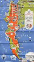 | Details | Boyle, Stuart | 1931 |
| Elegant lithographed pictorial map of the Cape Peninsula South Africa |
|
Boyle, Stuart |
|
| 1931 |
| LOC:14 |
| $550.00 | Boyle--Stuart | Elegant-lithographed-pictorial-map-of-the-Cape-Peninsula-South-Africa | Lovely, original pictorial map of the Cape Peninsula in South Africa by illustrator Stuart Boyle. Stuart Boyle illustrated several books including Evelyn Waugh’s The Loved One.
<br><br>
This fine map of the Cape Peninsula is characterized by elegant, colorful design and superb execution, with locations, notes, and literary quotes identified in scrollwork captions. These include:
<div class="indenttextblocksingle">
<ul style="list-style-type: circle;"></li>
<li>For the seas call and the stars call, and oh! the call of the sky- G. Gould.</li>
<li>White as sand of Muizenberg spun before the gale - Kipling.</li>
<li>Under hot Constantia broad the vineyards lie - Kipling</li>
<li>Good bathing to be had here.</li>
<li>Some say this drive in unequalled anywhere.</li>
<li>Fish simply ask to be caught here.</li>
<li>These are the twelve apostles</li>
</ul>
</div>
Only three holdings of this 1931 pictorial map are identified in WorldCat. No copies currently for sale were located.
<br><br>
Verso with text and numerous photogravure images of locations around the Cape Peninsula.
<br><br>
Issued by the Cape Peninsula Publicity Association and the South African Railways and Harbours Administration in 1931. Printed by the Cape Times. |
| 4705 | 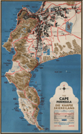 | Details | Cape Peninsula Publicity Association | 1955 |
| The Cape Peninsula, South Africa |
|
Cape Peninsula Publicity Association |
|
| 1955 |
| LOC:88 |
| $200.00 | Cape-Peninsula-Publicity-Association | The-Cape-Peninsula--South-Africa | Colorful 4-color lithographed map of Cape Town, South Africa with numerous fishing sites identified in False Bay, Table Bay, Hout Bay, Chapmans Bay and the coastal margins of the Cape Peninsula as far south as the Cape of Good Hope. Very interesting and colorful map with topographic detail of the nearby Table Mountain, Twelve Apostles, Steenberg and Constantia Mountains. Includes Seal Island, Roman Rock.
<br></br>
Original highly graphic map of 1955 with photos and text on the verso of a folding brochure "The Cape Peninsula- A Map for Visitors."
<br></br>
Drawn by PLIK. Cape Peninsula Publicity Association. Cape Town. 4-colour litho plates by Photo Process (Pty.) Ltd. Cape Town. Printed by Galvin and Sales (Pty.) Ltd. Cape Town. Copyright 1955 |