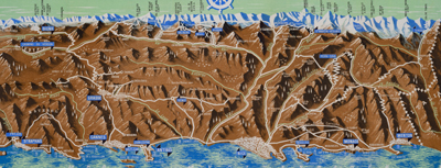
DESCRIPTION: The recto features a highly detailed birds-eye view and map of the French coast, extending from St. Tropez and St. Raphael to Menton. It highlights various towns, such as Grasse, Cannes, Juan-les-Pins, Antibes, Nice, and Monaco. Additionally, it offers a helpful route map that indicates the names and distances of cities along two travel segments for a journey from St. Raphael to Menton:
- From Nice to St. Raphael via the Corniche de l'Esterel
- From Nice to Menton along the Corniches
 Nice-Cannes-Menton et les routes du littoral. Nice-Cannes-Menton et les routes du littoral.
Although labeled "Ed 54" on the cover, suggesting a publication date of 1954, the included photographs appear to be from the early 1940s. The map's top section displays the names of mountain peaks in the background, and all text is in French.
On the verso, you'll find extra routes, photographs, and descriptions of various sights and attractions. After reviewing the brochure, it's clear that this area is an excellent candidate for a future vacation destination.
Published by France's Direction générale du Tourisme under the Ministry of Public Works, Transport, and Tourism, this edition is identified as "Ed. 54."
PUBLICATION DATE: 1954
GEOGRAPHIC AREA: France
BODY OF WATER: Mediterranean Sea
CONDITION: Very good.
Clean and fresh. Only light wear to folds… lots of use left.
COLORING: Process coloring
ENGRAVER:
SIZE: 20
" x
17 "
ITEM PHYSICAL LOCATION: 88
PRICE: $195
ADD TO CART

|