DESCRIPTION: If you collect antique Boston paper or you are looking for an original, unique, one-of-a-kind gift for someone then consider this rare piece of Boston history:
This is a manuscript or hand drawn plan, a cadastral map of Commonwealth Avenue in Back Bay, Boston, Mass. from January, 1882. The map was the source map, a master map, a base map, for blueprint copies made around 1882 by the Civil Engineering firm of Fuller and Whitney who styled themselves "Back Bay Engineers". Fuller and Whitney tracked the owners name, lot width and lot number on Commonwealth during the fill and development of Boston's Back Bay in the latter half of the 19th century. Covers five blocks on Commonwealth Ave. between Dartmouth Street and West Chester Park, now called Massachusetts Ave.
Fuller and Whitey regularly used this master copy to publish beautiful blueprints tracking the progress of the Boston Back Bay project in the 1880's. To produce a blueprint they would lay a sheet of tracing paper across this master page and have a draftsman neatly trace and letter the plan in water-soluble ink. When that trace was complete they laid the trace across a sheet of unexposed blueprint paper and placed both sheets under the bright sun for several minutes to expose it, just like an old style contact photograph. The exposed print was then washed to develop it.
Although multiple blueprints may have been produced (I don't know of any) this is the only master manuscript source plan. They aren't making any more of these.
What a conversation piece! Includes notes from the engineers about the how the owner's names were put on the map and about lot widths.
Fuller and Whitey's document index file numbers 741 and 858.
Other Boston manuscript maps are available. Contact us for more information.
Fuller and Whitney
Back Bay Engineers (1872- 1888)
From 1872 to 1888, Fuller & Whitney Civil Engineers thrived as a partnership between J. Franklin Fuller and William H. Whitney. In 1888, Whitney assumed sole proprietorship, boldly renaming the firm "William H. Whitney" to reflect his visionary leadership.
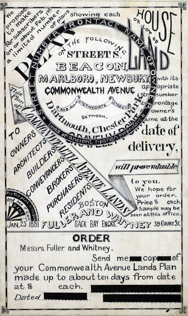 1881 MS Trace Fuller and Whitney Ad and Order Form 1881 MS Trace Fuller and Whitney Ad and Order Form
(not included)
In his autobiography Whitney refers to his work with the latest cutting-edge reprographic technology- blueprinting: “In September 1881 I received a bronze medal at the Massachusetts Charitable Mechanic Association Exhibit for sun or blue prints. I developed a process from the French and used it in illustrating the growth of Back Bay lands. I issued to subscribers monthly schedules and maps showing the changes of ownership, increase in value, improvement by filling and public works.” (The New England Historical and Genealogical Register. Vol 64, January 1910. Number 253. p. lix)
PUBLICATION DATE: 1882
GEOGRAPHIC AREA: United States
BODY OF WATER: N/A
CONDITION: Fair.
Solid but shows wear and grime from frequent use. A few tears and clipper corners.
COLORING: None
ENGRAVER:
SIZE:
" x
"
ITEM PHYSICAL LOCATION:
PRICE: $850
ADD TO CART

|