| | Thumbnail | | Creator | Date | Title / Author / Date / Location | Price | | | Description |
| 2546 |  | Details | Fuller and Whitney | 1882 |
| Rare blueprint cadastral plan Boylston Street, Boston Back Bay |
|
Fuller and Whitney |
|
| 1882 |
| LOC:0 |
| $650.00 | Fuller-and-Whitney | Rare-blueprint-cadastral-plan-Boylston-Street--Boston-Back-Bay | This fine single leaf with printing on two sides is a rare early example of the adoption and adaptation of a new printing technology (blueprinting). William Whitney's use of blueprinting enabled his firm to publish works contemporaneously with the ongoing land making in Boston's Back Bay, thus reducing cycle time and gaining greater control over his firm's publication of cadastral data. Using blueprints Fuller and Whitney could research, design, create artwork, and print their own works.
<br></br>
Original blueprint of Boylston Street in Boston, Massachusetts east of Massachusetts Avenue (Ex. West Chester Park) to Dartmouth Street. During the Back Bay Land making Project of the mid-19th century fill averaging 20 feet in depth was added to 450 acres of mud flats that lay to the west of Boston's Public Garden. Proceeding from east to west, by 1870 the land was filled as far as Exeter Street and land making was completed to West Chester Park by 1882.
<br></br>
Blueprint on the recto consist of a plan of Boylston Street from Fuller and Whitney's 1882 issue of "Schedule of Sales Commonwealth Avenue Lands, 1882. With Plan." On the verso a table of data as above. No. 7.
<br></br> |
| 6827 | 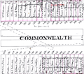 | Details | Fuller and Whitney | 1882 |
| Rare manuscript surveyors cadastral plan of Commonwealth Avenue in Boston Mass |
|
Fuller and Whitney |
|
| 1882 |
| LOC: |
| $850.00 | Fuller-and-Whitney | Rare-manuscript-surveyors-cadastral-plan-of-Commonwealth-Avenue-in-Boston-Mass | If you collect antique Boston paper or you are looking for an original, unique, one-of-a-kind gift for someone then consider this rare piece of Boston history:
<br><br>
This is a manuscript or hand drawn plan, a cadastral map of Commonwealth Avenue in Back Bay, Boston, Mass. from January, 1882. The map was the source map, a master map, a base map, for blueprint copies made around 1882 by the Civil Engineering firm of Fuller and Whitney who styled themselves "Back Bay Engineers". Fuller and Whitney tracked the owners name, lot width and lot number on Commonwealth during the fill and development of Boston's Back Bay in the latter half of the 19th century. Covers five blocks on Commonwealth Ave. between Dartmouth Street and West Chester Park, now called Massachusetts Ave.
<br><br>
Fuller and Whitey regularly used this master copy to publish beautiful blueprints tracking the progress of the Boston Back Bay project in the 1880's. To produce a blueprint they would lay a sheet of tracing paper across this master page and have a draftsman neatly trace and letter the plan in water-soluble ink. When that trace was complete they laid the trace across a sheet of unexposed blueprint paper and placed both sheets under the bright sun for several minutes to expose it, just like an old style contact photograph. The exposed print was then washed to develop it.
<br><br>
Although multiple blueprints may have been produced (I don't know of any) this is the only master manuscript source plan. They aren't making any more of these.
<br><br>
What a conversation piece! Includes notes from the engineers about the how the owner's names were put on the map and about lot widths.
<br><br>
Fuller and Whitey's document index file numbers 741 and 858.
<br><br>
<b>Other Boston manuscript maps are available. Contact us for more information.</b> |
| 5397 | 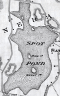 | Details | Fuller and Whitney | 1882 |
| Rare Manuscript Foundational Map of the Middlesex Fells Massachusetts |
|
Fuller and Whitney |
|
| 1882 |
| LOC: |
| $0.00 | Fuller-and-Whitney | Rare-Manuscript-Foundational-Map-of-the-Middlesex-Fells-Massachusetts | SOLD<br><br>A recently uncovered landmark in early American conservation history, this 1882 map is the earliest known unified depiction of the Middlesex Fells and a nationally significant artifact from the birth of forest and open-space preservation in the United States. Created in the same year that Massachusetts enacted the first public-domain conservation law, the map captures the moment when advocates began to view the Fells as a single landscape worthy of protection. It also appears to be the earliest known use of the then cutting-edge blueprinting process for a conservation map, underscoring its pioneering role in both environmental advocacy and cartographic technology.
<br><br>
Compiled in November 1882—three years after Sylvester Baxter introduced the name “Middlesex Fells,” two years after Elizur Wright and Wilson Flagg founded the Middlesex Fells Association, and only six months after passage of the Public Domain Act (Chapter 255, Acts of 1882)—the map’s title closely mirrors the statutory language authorizing preservation of forests and water supply. Fuller & Whitney describe land “designed to be set apart as a Public Domain for the preservation and production of Forest Trees and the Water Supply of many Cities & Towns,” echoing the Act almost verbatim. Issued in immediate response to this new legal authority, the 1882 sheet stands as a deliberate visual expression of the law’s intent and a foundational document in America’s earliest forest-preservation movement.
<br<br>Manuscript master surveyor's ink trace map on tracing cloth. MS pencil index notation bottom right: “973 – 974.<br><br>Possibly unpublished. The map predates the Appalachian Mountain Club map by four years and the Topographical Map of Middlesex Fells Reservation by thirteen.
<br><br> |
| 6519 | 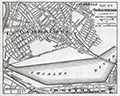 | Details | Fuller and Whitney | 1885 |
| Charles River Basin and Harvard Bridge Economic Studies |
|
Fuller and Whitney |
|
| 1885 |
| LOC:300 |
| $1,900.00 | Fuller-and-Whitney | Charles-River-Basin-and-Harvard-Bridge-Economic-Studies | Manuscript surveyors-trace economic option studies for road approaches and the proposed West Chester Park Bridge (now, Harvard Bridge, MIT Bridge, or Massachusetts Avenue Bridge). Eight surveyors' trace documents to support civil engineering and economic options for the placement of the Harvard Bridge, spanning the Charles River between Boston and Cambridge, Massachusetts. General plans for the new bridge were approved in July 1887; the bridge opened in September 1891.
<br><br>
The lot consists of eight MS pen and ink traces (for blueprint production) consisting of two base maps of Boston and Cambridge as well as six MS trace sheets with street and bridge options. The two base maps show the Charles River Basin with the existing West Boston Bridge (Longfellow Bridge) and road network. One map has much greater detail on street names and improved larger lettering.
<br><br>
Six map overlays:<br>
<div class="indenttextblocksingle">
<ul style="list-style-type: circle;">
<li>No 1. Shows the proposed new route as well as text and tabular information for the gain or loss of time over the proposed new route.</li>
<li>No. 2 Shaded area shows lands of the Charles River Embankment Company (proposed Esplanade),
proposed approaches to the Charles River Esplanade and proposed West Chester Park Bridge (aka Harvard Bridge)</li>
<li>No. 3 Approaches for the proposed West Chester Park Bridge (east of the final location)</li>
<li>No. 4 Second option. Bridge located at West Chester (aka Massachusetts Avenue) but terminated slightly more to the east.</li>
<li>No. 5 Third option. Bridge at West Chester, and a proposed wide avenue extending to the end of Commonwealth in Cambridge.</li>
<li>No. 6 Fourth option. No Esplanade </li>
</ul>
</div>
Scale 1650 feet to one inch. |
| 2537 | 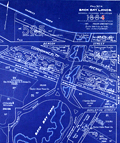 | Details | Fuller and Whitney | 1885 |
| Antique blueprint surveyor's plan of Boston's Back Bay Fens |
|
Fuller and Whitney |
|
| 1885 |
| LOC:0 |
| $500.00 | Fuller-and-Whitney | Antique-blueprint-surveyor-s-plan-of-Boston-s-Back-Bay-Fens | Scarce original cadastral blueprint plan (#6) of a portion of the Boston' Back Bay area west of Massachusetts Avenue less than 30 years after the area was created through land making. This plan provides a good representation of Olmsted's original vision for the Back Bay Park. Antique blueprint maps and plans from the 1889's are scarce as the technology to create blueprints was only widely adopted after 1870.
<br></br>
The area for this blueprint in Boston, Massachusetts is bounded on three sides by the Charles River, West Chester Park (now Massachusetts Avenue) and Boylston Street. Charlesgate East and Charlesgate West are named Ipswich Street and Jersey Street respectively. Verso is blank.
<br></br>
During the period 1872 to 1888 Fuller & Whitney Civil Engineers, was conducted as a partnership between J. Franklin Fuller and William H. Whitney with offices at 39 Court Street, Boston, Mass. Whitney assumed sole control of the firm in 1888 and changed the name to William H. Whitney.
<br></br>
In his autobiography Whitney refers to his work with the latest cutting-edge reprographic technology- blueprinting: <div class="indenttextblock">“In September 1881 I received a bronze medal at the Massachusetts Charitable Mechanic Association Exhibit for sun or blue prints. I developed a process from the French and used it in illustrating the growth of Back Bay lands. I issued to subscribers monthly schedules and maps showing the changes of ownership, increase in value, improvement by filling and public works.” (The New England Historical and Genealogical Register. Vol 64, January 1910. Number 253. p. lix).</div>
Fuller and Whitney are best know for their work documenting Back Bay land making activity, particularly a six-sheet set of blueprints: "A SET OF PLANS FOR THE BACK BAY 1814-1881 ILLUSTRATING THE RAPID PROGRESS IN THE DEVELOPMENT OF THE TERRITORY FOR ITS PRESENT AND PROPOSED USE." (Boston, 1881). |
| 2540 | 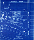 | Details | Fuller and Whitney | 1885 |
| Antique blueprint engineer's plan of Boston's Charlesgate East area |
|
Fuller and Whitney |
|
| 1885 |
| LOC:86 |
| $375.00 | Fuller-and-Whitney | Antique-blueprint-engineer-s-plan-of-Boston-s-Charlesgate-East-area | Original rare cadastral blueprint plan from September 22, 1885 providing detail for a portion of Boston's Back Bay on Beacon Street, Marlborough Street, and Commonwealth Avenue west of West Chester Park (Massachusetts Avenue) and east of Ipswich Street (Charlesgate East). At center left the reader will find the Beacon Entrance to Back Bay Park.
<br></br>
This blueprint, and perhaps other like it, were the end product created from <a href="https://www.rarecharts.com/ShowDetail/Creator/Fuller-and-Whitney/Title/Antique-manuscript-engineers-traced-plan-of-Boston-s-Charlesgate-East-area/2543" target="_blank">a manuscript trace document</a> by William H. Whitney.
</div>
Verso is blank.
<br></br>
During the period 1872 to 1888 Fuller & Whitney Civil Engineers, was conducted as a partnership between J. Franklin Fuller and William H. Whitney with offices at 39 Court Street, Boston, Mass. Whitney assumed sole control of the firm in 1888 and changed the name to William H. Whitney.
<br></br>
In his autobiography Whitney refers to his work with the latest cutting-edge reprographic technology- blueprinting: <div class="indenttextblock">“In September 1881 I received a bronze medal at the Massachusetts Charitable Mechanic Association Exhibit for sun or blue prints. I developed a process from the French and used it in illustrating the growth of Back Bay lands. I issued to subscribers monthly schedules and maps showing the changes of ownership, increase in value, improvement by filling and public works.” (The New England Historical and Genealogical Register. Vol 64, January 1910. Number 253. p. lix).</div> |
| 2543 | 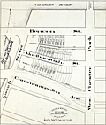 | Details | Fuller and Whitney | 1885 |
| Antique manuscript engineers traced plan of Boston's Charlesgate East area |
|
Fuller and Whitney |
|
| 1885 |
| LOC:86 |
| $500.00 | Fuller-and-Whitney | Antique-manuscript-engineers-traced-plan-of-Boston-s-Charlesgate-East-area | William H. Whitney was a very early adopter of the "blue process" or blueprinting . Both this trace and the <a href="https://www.rarecharts.com/ShowDetail/Creator/Fuller-and-Whitney/Title/Antique-blueprint-engineer-s-plan-of-Boston-s-Charlesgate-East-area/2540" target="_blank">blueprint produced from this trace</a> were created by Whitney just 4 years after the earliest recorded use of blueprints for his Boston-based civil engineering firm.
<br><br>
This rare artifact is the original manuscript cadastral ink trace on tracing cloth from September 22, 1885 providing plan detail for a portion of the Boston Back Bay on Beacon and Marlborough Streets and Commonwealth Avenue west of West Chester Park (Massachusetts Avenue) and east of Ipswich Street (Charlesgate East). This trace would have been used as the reproducible master source to create one or more blueprints, then a new reprographic technology.
<br><br>
With Fuller & Whitney's ink oval over stamp. MS number in pencil at bottom right: "1277".
<br></br>
</div> |
| 2541 | 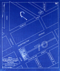 | Details | Fuller and Whitney | 1886 |
| Antique blueprint plan of Boston near Huntington and Massachusetts Avenues |
|
Fuller and Whitney |
|
| 1886 |
| LOC: |
| $300.00 | Fuller-and-Whitney | Antique-blueprint-plan-of-Boston-near-Huntington-and-Massachusetts-Avenues | Original cadastral blueprint plan from Jan. 1, 1886 of a portion of the Boston' Back Bay east of Massachusetts Avenue. The area includes the current location of the Boston Philharmonic Orchestra at 236 Huntington Ave. In the upper portion of the plan an artifact of the blueprint process reveals where a piece of lint or vegetation landed between the surveyor's trace and blueprint paper during exposure of the paper to sunlight.
<br></br>
The area for this blueprint in Boston, Massachusetts is bounded on three sides by Falmouth Street, West Chester Park (now Massachusetts Avenue) and St. Botolph Street. Verso is blank. Sheet is labeled "M". |
| 5318 | 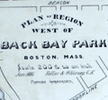 | Details | Fuller and Whitney | 1886 |
| Fenway Park land manuscript engineering studies Boston Back Bay |
|
Fuller and Whitney |
|
| 1886 |
| LOC:1000 |
| $0.00 | Fuller-and-Whitney | Fenway-Park-land-manuscript-engineering-studies-Boston-Back-Bay | One of a kind engineer's manuscript trace map and planning studies in the Back Bay of Boston, Massachusetts for land that now includes the site for <b>Fenway Park</b>. This is an important record for the development of the Boston Back Bay that provides insight into Back Bay land making project priorities and planning at the end of the 19th century.
<br></br>
The base map with associated eight planning studies encompass an area bounded by Brookline Avenue, the Boston and Albany railroad right-of-way, and Audubon Road. In 1886 Fenway Park (built in 1912) was not yet planned, therefore all the land was considered for residential purposes. An engineering study that includes a ball park does not exist.
<br></br>
One manuscript pen and ink master map on 'surveyors cloth' paper with nine manuscript overlays- one reflecting land ownership as it was and eight studies or future design options for alternate land plat options on 'surveyors cloth'. Each overlay 'study' presents an alternative layout for platting the land. With each study the waste percentage is prominently displayed next to the index number for the study. The inferred reason is that the purpose of the studies was to arrive at a configuration that minimized land waste.
<br></br>
No blueprints of the finished product are known to exist nor are there any other copies of this planning study.
<br></br>
Manuscript pen and ink with blue outline under color to provide dimension for the Back Bay Fens on the finished product for which this trace was intended- blueprint copies.
<br></br>
Fuller and Whitney's MS surveyor's index number in pencil: "1335" at lower left.
<br></br>
Note on photographs: (1) Shows the base map on which the 9 overlays could be placed. (2) Shows the base map with the overlay for the existing cadastral plat in 1886. (3) Shows the base map, original plat, and the eight planning studies arrayed around the base map. |