DESCRIPTION: One of a kind engineer's manuscript trace map and planning studies in the Back Bay of Boston, Massachusetts for land that now includes the site for Fenway Park. This is an important record for the development of the Boston Back Bay that provides insight into Back Bay land making project priorities and planning at the end of the 19th century.
The base map with associated eight planning studies encompass an area bounded by Brookline Avenue, the Boston and Albany railroad right-of-way, and Audubon Road. In 1886 Fenway Park (built in 1912) was not yet planned, therefore all the land was considered for residential purposes. An engineering study that includes a ball park does not exist.
One manuscript pen and ink master map on 'surveyors cloth' paper with nine manuscript overlays- one reflecting land ownership as it was and eight studies or future design options for alternate land plat options on 'surveyors cloth'. Each overlay 'study' presents an alternative layout for platting the land. With each study the waste percentage is prominently displayed next to the index number for the study. The inferred reason is that the purpose of the studies was to arrive at a configuration that minimized land waste.
No blueprints of the finished product are known to exist nor are there any other copies of this planning study.
Manuscript pen and ink with blue outline under color to provide dimension for the Back Bay Fens on the finished product for which this trace was intended- blueprint copies.
Fuller and Whitney's MS surveyor's index number in pencil: "1335" at lower left.
Note on photographs: (1) Shows the base map on which the 9 overlays could be placed. (2) Shows the base map with the overlay for the existing cadastral plat in 1886. (3) Shows the base map, original plat, and the eight planning studies arrayed around the base map.
Fuller and Whitney
Back Bay Engineers (1872- 1888)
From 1872 to 1888, Fuller & Whitney Civil Engineers thrived as a partnership between J. Franklin Fuller and William H. Whitney. In 1888, Whitney assumed sole proprietorship, boldly renaming the firm "William H. Whitney" to reflect his visionary leadership.
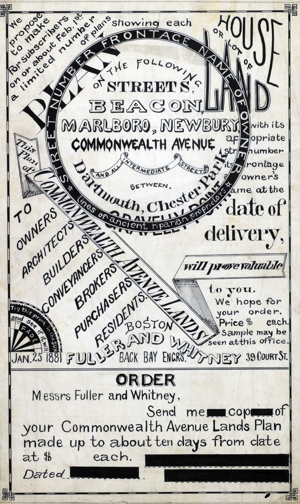 1881 MS Trace Fuller and Whitney Ad and Order Form 1881 MS Trace Fuller and Whitney Ad and Order Form
(not included)
In his autobiography Whitney refers to his work with the latest cutting-edge reprographic technology- blueprinting: “In September 1881 I received a bronze medal at the Massachusetts Charitable Mechanic Association Exhibit for sun or blue prints. I developed a process from the French and used it in illustrating the growth of Back Bay lands. I issued to subscribers monthly schedules and maps showing the changes of ownership, increase in value, improvement by filling and public works.” (The New England Historical and Genealogical Register. Vol 64, January 1910. Number 253. p. lix)
PUBLICATION DATE: 1886
GEOGRAPHIC AREA: United States
BODY OF WATER: Boston Back Bay Fens
CONDITION: Very Good.
Signs of handling, a bit grubby, but otherwise near perfect.
COLORING: Blue coloring from the verso, as was the practice with trace artifacts.
ENGRAVER:
SIZE: 25
" x
15 "
ITEM PHYSICAL LOCATION: 1000
PRICE: $
ADD TO CART

|