DESCRIPTION: Rare folding pictorial map of the Monterey Bay Region in California by John Courtney Sandefur. Sandefur's pictograms show the obvious influence of an earlier cartograph of the Monterey Region by Ruth Taylor White.
The map was published by Hotel Jeffery ca. early 1950s, then conducting business in Salinas, California for over 90 years. Colorful compass rose bearing a dog's image and the motto of the Hotel Jeffery- "Friendly."
Verso with text about the recreational activities and resources available in the Monterey Bay Area and the Salinas Valley including Pacific Grove, Carmel, Fort Ord, Santa Cruz, and Watsonville.
The Jeffery Hotel in Salinas, California was opened in 1888 at the corner of Alisal and Main Streets by William "Bill" Jeffery. In the 1970’s the original three-story Jeffery Hotel was demolished.
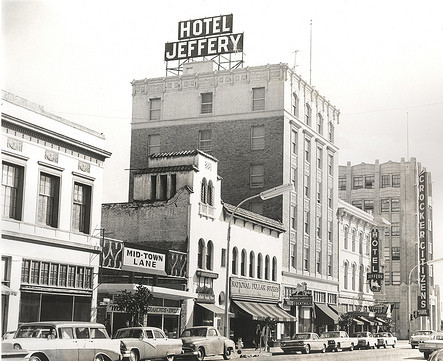 Hotel Jeffery. Courtesy U. California: https://calisphere.org/ Hotel Jeffery. Courtesy U. California: https://calisphere.org/
PUBLICATION DATE: 1954
GEOGRAPHIC AREA: United States
BODY OF WATER: Monterey Bay
CONDITION: Good.
Ample margins. Solid. Some browning toward the center of the map.
COLORING: Lithographed color.
ENGRAVER:
SIZE: 10
" x
7 "
ITEM PHYSICAL LOCATION: 87
PRICE: $150
* Next Shipping Date is June 30, 2026

|