DESCRIPTION: SOLD
A scarce two-volume indexed set of colored fire insurance maps for West Palm Beach, Florida by the Sanborn Map Company. Issued for the insurance industry’s internal use, Sanborn maps were the most comprehensive commercial record of fire risk and urban building characteristics in the U.S. before aerial photography and digital databases transformed insurance underwriting practices.
A fine set of maps reflecting the post WWII, baby-boom era in West Palm Beach. The original volumes were issued in 1952 and new pages were added up to 1957 to reflect changes in the buildings represented. The maps record West Palm Beach ca. 1957 as it issued an $18-million bond to modernize sewers and extend fire-protection systems west of downtown, capturing a pivotal moment when the pre-war resort grid gave way to a growing suburban city.
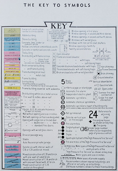
These original Sanborn Fire Insurance Atlases for West Palm Beach, Florida (1952–1957) document the city at the height of its post-war expansion. Streets, blocks, and individual buildings are shown in full color, coded for construction type, height, and occupancy, with every hydrant, stairwell, and fire wall marked for underwriters.
 Sanborn Map Company map legend Sanborn Map Company map legend
Sanborn Map Company
The Sanborn Map Company was founded as the “D. A. Sanborn National Diagram Bureau” in 1866 by Daniel Alfred Sanborn, a civil engineer and surveyor who had previously prepared fire insurance maps for Aetna Insurance Company. From its headquarters in New York City, the firm developed a systematic, color-coded mapping style that quickly became the industry standard for assessing fire risk in urban areas across the United States. Each map showed every building footprint, construction material, number of stories, location of windows, doors, and hydrants—details insurers needed to calculate premiums and underwrite fire policies. By the 1880s, Sanborn was producing atlases for hundreds of cities, updating them every few years as buildings changed or cities expanded.
At its peak in the early 20th century, the Sanborn Map Company employed thousands of field surveyors and cartographers and maintained a collection covering more than 12,000 U.S. towns and cities. The company’s atlases became essential tools not only for insurance underwriters but also for city planners, architects, and historians. After World War II, aerial photography and digital mapping gradually replaced the hand-drawn surveys, and Sanborn transitioned into modern geospatial and GIS services. Today, the original printed volumes—many once restricted to insurance offices—are prized historical artifacts, valued for their precision, artistry, and unmatched documentation of America’s urban development.
PUBLICATION DATE: 1952
GEOGRAPHIC AREA: United States
BODY OF WATER:
CONDITION: Very Good.
Each page is enclosed in a plastic sleeve which is then collated numerically into the volume.
COLORING: Litho. Color.
ENGRAVER:
SIZE: 11
" x
13 "
ITEM PHYSICAL LOCATION:
PRICE: $
ADD TO CART

|