| | Thumbnail | | Creator | Date | Title / Author / Date / Location | Price | | | Description |
| 5294 | 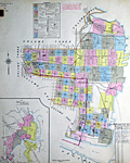 | Details | Sanborn Map Company | 1913 |
| Insurance Atlas for Jacksonville Florida Vol. 2 |
|
Sanborn Map Company |
|
| 1913 |
| LOC: |
| $0.00 | Sanborn-Map-Company | Insurance-Atlas-for-Jacksonville-Florida-Vol--2 | SOLD
<br></br>
Sanborn's Insurance Atlas Volume two for Jacksonville, Florida with 1913 copyright date and pasted updates from 1920's, 1940's - 1950's. The manuscript correction record shows 12 sets of corrections between April 1949 and April 1960, but earlier updates appear to have been made. A very heavy atlas published by Sanborn Map Company, Broadway New York.
<br></br>
Volume two coverage includes downtown north Jacksonville with almost all important river frontage along the St. John's River south of Long Branch Creek. A quick sampling of features includes Jacksonville Memorial Stadium- the GATOR BOWL, City Hall, Jacksonville Gas Company, Sinclair Refining Company storage plant, Merrill-Stevens Dry Dock and Repair.
<br></br>
Pages have not been counted or checked for completeness but the sheets are generally in good condition with linen binder's tabs still holding all tightly in place in the metal binder. Built to last! Many sheets are original to 1913 (see bottom right corner) with pasted updates; some sheets have been replaced over time.
<br></br>
Numerous (hundreds) of pasted updates over five decades make this an invaluable cartographic researcher's reference source for Jacksonville, Florida in the first half of the 20th century. In some cases entire new updated sheets are pasted over old sheets. It is possible, in theory, to perform an "archaeological" unpasting all the way down to the original base maps from 1913. For example sheets 171 and 172 show pasted overlays of an new East Expressway laid over the original 1913 base maps, potentially providing a clear picture of urban renewal in action. |
| 7964 | 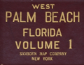 | Details | Sanborn Map Company | 1952 |
| West Palm Beach Florida Sanborn Atlas Two Volume Set |
|
Sanborn Map Company |
|
| 1952 |
| LOC: |
| $0.00 | Sanborn-Map-Company | West-Palm-Beach-Florida-Sanborn-Atlas-Two-Volume-Set | SOLD <br><br>A scarce two-volume indexed set of colored fire insurance maps for <b>West Palm Beach, Florida</b> by the Sanborn Map Company. Issued for the insurance industry’s internal use, Sanborn maps were the most comprehensive commercial record of fire risk and urban building characteristics in the U.S. before aerial photography and digital databases transformed insurance underwriting practices.
<br><br>
A fine set of maps reflecting the post WWII, baby-boom era in West Palm Beach. The original volumes were issued in 1952 and new pages were added up to 1957 to reflect changes in the buildings represented. The maps record West Palm Beach ca. 1957 as it issued an $18-million bond to modernize sewers and extend fire-protection systems west of downtown, capturing a pivotal moment when the pre-war resort grid gave way to a growing suburban city.
<br><br>
These original Sanborn Fire Insurance Atlases for West Palm Beach, Florida (1952–1957) document the city at the height of its post-war expansion. Streets, blocks, and individual buildings are shown in full color, coded for construction type, height, and occupancy, with every hydrant, stairwell, and fire wall marked for underwriters.
<br><br>
<div id="0" align="center">
<a title=""></a>
<img id="6450" src="/ZoomifyImages/SC_7964/Sanborn_Map_Symbols_400w.jpg" alt="Sanborn Map Company map legend" width="300"/> <br><br> <font size="-2">Sanborn Map Company map legend</font>
</div> |