DESCRIPTION: Extremely rare, self-published map by C.A. Rice: "Lines of March and Border Patrols, In My Mexican Border Service. 1916 - 1917." Rice's map records the first deployment of the U.S. National Guard in time of emergency or war. A very desirable map for collectors of Texas cartography. Only 2 examples in WorldCat.
Rare map of the Texas border during the 1916-1917 Mexican Expedition or Mexican Punitive expedition, a military action taken by the United States Army during 1916 - 1917 in the second decade of the 20th century. Covers a 20 mile-wide swath of the U.S. along the border with Mexico from Rio Grande City, Texas south to the Gulf of Mexico.
A detail-filled map with military and march roads, camps and outposts, railroads, trails, rifle ranges, and telephone lines.
The action was taken in response to the attack of Pancho Villa across the U.S. border on the town of Columbus, New Mexico. Villa's attack, which killed 19, added to his previous depredation in which he kidnapped and slaughtered 18 U.S. citizens.
As a response to Villa's attacks, the President authorized General Pershing to pursue Villa and his band of rebels hundreds of miles into Mexico. As authorized by the National Defense Act of 1916, the National Guard was mobilized for the first time to man the U.S. border with Mexico. Quickly, National Guard Units deployed from 21 states and by August 1916, an estimated 117,000 guardsman were stationed along the U.S. side of the border, although they were unable to cross over into Mexico.
By Act of U.S. Congress in 1918 the Mexican Border Service Medal was a established as a military award for service between May 9, 1916 and March 24, 1917, or with the Mexican Border Patrol between January 1, 1916 to April 6, 1917. The medal recognizes those military service members who were assigned to the U.S.-Mexico border at the period of time when the United States was on the verge of all-out war with Mexico.
Charles A. Rice (1885 - 1931)
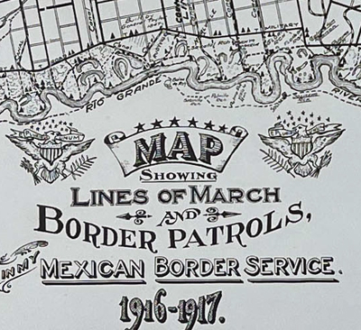 Title from Rice's map of the Texas Border Title from Rice's map of the Texas Border
Charles A. Rice, a native of Buffalo, New York was educated as a Civil Engineer. Rice is reported to have spent a year as Sergeant with the 74th Infantry during its brief deployment to Pharr (near McAllen) on the Texas border July 1, 1916 to February 14, 1917. The Regiment was reported still training in October 1916, so Rice's border enforcement actions may have been limited [1].
After the war Rice is reported as living in McAllen, Texas until his death in 1931.
Contemporananeouly with his Border Patrol map, Rice also published a memorial to soldiers in the 16th Cavalry which was constituted 1 July 1916 in the Regular Army as the 16th Cavalry and organized at Fort Sam Houston, Texas. This memorial for Troop A is dated July 2, 1916 but aimed at WWI participants post April 6, 1917.
[1] Kaffenberger, Karl G. "The Seventy-Fourth Infantry". New York Division National Guard War Record. Rupert Burdick ed., 1917. New York. Burdick and King. Pages 97 - 101.
PUBLICATION DATE: 1917
GEOGRAPHIC AREA: United States
BODY OF WATER: Rio Grande River
CONDITION: Good.
Generally clean and bright with scattered light stains as shown. Far left side slightly darker for 6". Solid. 1/2" tear at right center margin with old tape repair from verso, outside image.
COLORING: None
ENGRAVER:
SIZE: 39
" x
15 "
ITEM PHYSICAL LOCATION: 1402
PRICE: $8500
ADD TO CART *
* Next Shipping Date is May 14, 2024

|