| | Thumbnail | | Creator | Date | Title / Author / Date / Location | Price | | | Description |
| 7987 | 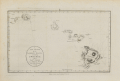 | Details | Harrison, John | 1784 |
| A New Chart of the Sandwich Islands including oWhyhee Hawaii |
|
Harrison, John |
|
| 1784 |
| LOC:130 |
| $1,100.00 | Harrison--John | A-New-Chart-of-the-Sandwich-Islands-including-oWhyhee-Hawaii | Engraved chart of the Hawaiian Islands issued shortly after the publication of the official account of Captain Cook’s third voyage (James King; June, 1784). This chart was published one month later in London by Harrison & Co., on July 1, 1784. It traces the routes of Cook’s ships Resolution and Discovery through the Hawaiian archipelago and highlights “oWhyhee” (Hawaiʻi), where Cook met his death in February 1779.
<br><br>
Based closely on Henry Roberts’ official chart but without the inset of Kealakekua Bay, Harrison’s version was created for a popular audience eager for news of the famous explorer’s final journey.
The map offers one of the earliest separately issued depictions of the Hawaiian Islands, capturing the moment when they first entered European geographic consciousness.
<br><br>
Printed from a finely engraved copper plate, the chart combines geographic accuracy with contemporary drama, naming each island and noting Cook’s fatal landing. Examples of this edition are far scarcer than those bound in the official voyage atlas, making it a sought-after piece for collectors of Pacific exploration and early Hawaiian cartography.
<br><br> |
| 438 | 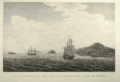 | Details | Blondela, Lieut. | 1797 |
| Vue du Mouillage des Fregates Francaises a L'Isle de Mowee |
|
Blondela, Lieut. |
|
| 1797 |
| LOC:59 |
| $450.00 | Blondela--Lieut- | Vue-du-Mouillage-des-Fregates-Francaises-a-L-Isle-de-Mowee | Engraved re-strike view of ships from the La Perouse expedition anchored off of Maui in the Hawaiian Islands at an anchorage now known as "La Perouse Bay". This is the first large-format view ever published of the island of Maui. From the "Atlas du Voyage de La Perouse". From a drawing by Lieutenant Blondela, Engraved by J.J. Avril; lettered by L. Aubert. No 14. <BR> </BR>
Believe the engraving is an early 20th century re-strike <b> from the original copper plate </b>produced by the Chalcographie du Louvre. La Chalcographie du Louvre is a repository of more that 13,000 original plates from the Louvre's archives, housed upstairs above the Louvre's Paris galleries . Upon request visitors can have a engraving produced from one of those original plates by master printers on museum-quality paper. V. 15<BR> </BR> |
| 724 | 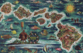 | Details | Feher, Joseph | 1950 |
| Dole Map of the Hawaiian Islands |
|
Feher, Joseph |
|
| 1950 |
| LOC:0 |
| $0.00 | Feher--Joseph | Dole-Map-of-the-Hawaiian-Islands | This map of Hawaii by Joseph Feher has been <b>sold</b> but in our inventory we now have one additional <a href=" https://www.rarecharts.com/ShowDetail/Creator/Feher--Joseph/Title/The-Dole-Map-of-the-Hawaiian-Islands/4983" target="_blank">Dole pictorial map of the Hawaiian Islands</a>.
<br></br>
Joseph Fehér (b. 1908) was a watercolorist active in Hawaii from about 1930 - 1960. Feher’s travel-related work was in demand for decades and included promotional posters and calendars for United Airlines and other corporate clients. |
| 4983 |  | Details | Feher, Joseph | 1950 |
| The Dole Map of the Hawaiian Islands |
|
Feher, Joseph |
|
| 1950 |
| LOC:63 |
| $0.00 | Feher--Joseph | The-Dole-Map-of-the-Hawaiian-Islands | SOLD<br><br> Original lithographed pictorial map of the Hawaiian Islands copyrighted by the Hawaiian Pineapple Company Ltd. 1950. Overall width 40.5 inches. Includes original legend at right. Pinholes in margins. Loose. Not laid down. No stains.
<br><br>
Artist Joseph Feher depicted the Hawaiian islands and adjacent waters with boats, fish, and typical objects and pursuits associated with the islands: flying fish, surfing, spear fishing, sailing, poi-making, hula dancers, etc. Islands of the State of Hawaii mentioned in the legend include: Kauai, Niihau, Oahu, Molokai, Lanai, Maui, Kahoolawe, and the big island- Hawaii.
<br></br>
This is the second of two "Dole Pineapple Maps", the first was published in 1937.
<br></br>
Lithography by Schwabacher-Frey.
<br></br>
Once known as the Sandwich Islands, the Hawaiian Islands first documented discovery by a westerner occurred in 1778 with the arrival of British explorer Captain James Cook.
<br></br> |
| 8090 | 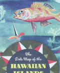 | Details | Feher, Joseph | 1950 |
| The Dole Map of the Hawaiian Islands |
|
Feher, Joseph |
|
| 1950 |
| LOC:63 |
| $575.00 | Feher--Joseph | The-Dole-Map-of-the-Hawaiian-Islands | Original lithographed pictorial map of the Hawaiian Islands copyrighted by the Hawaiian Pineapple Company Ltd. 1950. Overall width 40.5 inches. Lacking original legend at right. Pinholes in margins.
<br><br>
Artist Joseph Feher depicted the Hawaiian islands and adjacent waters with boats, fish, and typical objects and pursuits associated with the islands: flying fish, surfing, spear fishing, sailing, poi-making, hula dancers, etc. Islands of the State of Hawaii mentioned in the legend include: Kauai, Niihau, Oahu, Molokai, Lanai, Maui, Kahoolawe, and the big island- Hawaii.
<br></br>
This is the second of two "Dole Pineapple Maps", the first was published in 1937.
<br></br>
Lithography by Schwabacher-Frey.
<br></br>
Once known as the Sandwich Islands, the Hawaiian Islands first documented discovery by a westerner occurred in 1778 with the arrival of British explorer Captain James Cook.
<br></br> |