| | Thumbnail | | Creator | Date | Title / Author / Date / Location | Price | | | Description |
| 8064 | 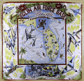 | Details | Anonymous | 1959 |
| Mid century scarf Eglin Air Force Base Florida |
|
Anonymous |
|
| 1959 |
| LOC: |
| $365.00 | Anonymous | Mid-century-scarf-Eglin-Air-Force-Base-Florida | This scarce and colorful mid-20th-century souvenir textile celebrates Eglin Air Force Base, Florida, presenting the installation as a principal proving ground of American air power during the early Cold War. A pictorial map of Florida labeled “Air Proving Ground Command” anchors the design, surrounded by illustrations of jet aircraft, test pilots, target vehicles, and specialized facilities. The textile combines cartographic imagery with promotional aviation art, adapting a souvenir-scarf format widely used for U.S. Air Force bases in the 1950s.<br><br>
The aircraft depicted represent the forefront of U.S. Air Force technology in the supersonic transition era. Shown at mid-left is a B-52 Stratofortress, identifiable by its long straight wings and eight-engine configuration, symbolizing strategic bomber testing. At upper left appears a Lockheed F-104 Starfighter, recognizable by its needle-like fuselage and extremely short wings, while at upper right is a Convair F-102 Delta Dagger, distinguished by its pure delta wing and nose intake. Also depicted is a Republic F-84F Thunderstreak, a swept-wing fighter-bomber widely used in weapons and systems evaluation during the mid-1950s. Additional imagery of test pilots and supersonic tow targets reinforces Eglin’s testing mission.<br><br>
The dating of the textile is supported by both the aircraft selection and the prominent reference to the Climatic Hangar, a facility completed at Eglin in 1954 and widely promoted in subsequent years for extreme-environment testing. The inclusion of the F-102, operational from 1956, and the F-104, which entered U.S. Air Force service in 1958, establishes a firm late-1950s timeframe, while the F-84F reinforces a mid-to-late 1950s context. The absence of later aircraft types or space-age imagery associated with the 1960s further supports an early Cold War date. These elements place the textile most convincingly in the late 1950s, circa 1958 to 1960.<br><br> |
| 1410 | 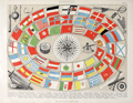 | Details | Brockhaus, F.A. | 1870 |
| Flaggenkarte or Naval Flags |
|
Brockhaus, F.A. |
|
| 1870 |
| LOC:0 |
| $99.00 | Brockhaus--F-A- | Flaggenkarte-or-Naval-Flags | Attractive German lithograph ca. 1870 of naval flags and ensigns titled "Seewesen". Shown with nautical and navigational artifacts including a sounding lead (60). As is typical on antique sounding leads, the center was left hollow to receive a soft piece of wax or tallow. The wax would pick up sediment (rocks, sand, silt) from the bottom enabling the navigator to possess simultaneous knowledge of another variable in addition to water depth.
<BR> </BR>
Together water depth and bottom composition helped provide a more accurate estimate of a ship's position. Sailing directions for hundred of years were likely to carry information about the sea floor such as "When the big rock is about 1/2 mile distant off your port beam and you find 20 fathoms of water and sandy bottom you are appproaching the rivers' mouth. Be sure to keep at least 6 fathoms and beware stony bottom at edges of channel."
<BR> </BR>
Other instruments include a compass, taffrail log, sextant, speaking trumpet and barometer.
<BR> </BR>
Attribution at bottom beneath mat reads : "Druck und verlag von F.A.Brockhaus in Leipzig". Archivally matted. Total size with mat is 17" W x 14" H. Sheet |
| 1105 | 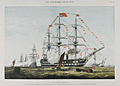 | Details | Illustrated London News | 1856 |
| The James Watt Man of War |
|
Illustrated London News |
|
| 1856 |
| LOC:9 |
| $145.00 | Illustrated-London-News | The-James-Watt-Man-of-War | Colorful lithograph of the twin decked ship-of-the line James Watt, a sail and steam powered vessel. In celebration of the queen's birthday sailors man the yards and cannons are fired in salute. Published by the Illustrated London News July 26, 1856. |
| 1004 | 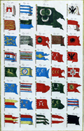 | Details | Diderot, Denis | 1730 |
| Marine Pavillons (Flags) Plate XX |
|
Diderot, Denis |
|
| 1730 |
| LOC:1 |
| $225.00 | Diderot--Denis | Marine-Pavillons-(Flags)-Plate-XX | Extremely decorative early 18th century hand-colored, engraved print depicting naval flags, pennants, and ensigns from across the world. Several flags contains the coat-of-arms of a royal family. Many flags contain a crescent moon, indicative of the Ottoman Empire. Plate 20. <BR> </BR>
Published by Diderot & D'Alembert in L'Encyclopédie. |
| 775 |  | Details | Hunt and Company | 1886 |
| Hunts Universal Yacht List 1886 |
|
Hunt and Company |
|
| 1886 |
| LOC:0 |
| $425.00 | Hunt-and-Company | Hunts-Universal-Yacht-List-1886 | A great gift for a sailing or yachting enthusiast. Hunts Universal Yacht List for 1886 contains 29 pages of colour printed yacht club flags and colored flags for individual yawls, schooners and cutters, with over 60 pages of interesting trade advertisements (many illustrated). This scarce, compact, antique volume is the 1886 edition in a series that were published annually between 1848 and 1914. Contains a long alphabetical list of specifications for 4800 largely British yachts including the following fields: name of yacht; rig; length; beam; tonnage; depth; owners; a key to the name of one the 61 participating yacht clubs; signal letters; year built; year altered; builder; sailmaker; and distinguishing flag.
<br></br>
Includes signal flags in color along with regatta dates, a list of owners, list of agents, staff and yachts of all the principal yacht clubs of the World, tide tables, prize winners, etc.
<br></br>
Bound in the original blue cloth boards, with gilt lettering and a royal crest to the upper cover. Professionally re-backed in gilt-decorated navy-blue morocco. Publisher: London: Hunt & Co., 119 Church Street, London. 422 pages. |
| 759 | 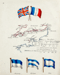 | Details | Anonymous | 1890 |
| Manuscript page with flags and a chart of British Channel |
|
Anonymous |
|
| 1890 |
| LOC:7 |
| $450.00 | Anonymous | Manuscript-page-with-flags-and-a-chart-of-British-Channel | A small manuscript chart of the English Channel. Decorated at top with the crossed flags of England and France this hand-drawn and hand-colored chart of the British Channel could have been created in the latter half of the 19th century to early 20th century by a British naval student or maritime officer candidate or quite possibly a member of the Sea Cadets Corps or its predecessor, the Naval Lads' Brigade. A legend in English describes features that would be found on a nautical chart of the period such as buoys, rocks, and bearings, but oddly the manuscript map does not contain any of those components with one exception, the Eddystone lighthouse southwest of Plymouth sound.
<br></br>
The most interesting aspect of the chart is the dotted line suggesting the route of a voyage between ports in England and France including Plymouth, Dartmouth, Torquay, Weymouth, Southampton, Sheerness, Cherbourg, and Guernsey
<br></br>
At bottom are drawn three signal flags including the Blue Peter, which was often used when preparing to leave port, or as the caption suggests, when requesting a pilot. Of the other two flags, the center flag is confirmed as a French registration flag that indicates that the vessel was registered to the Cherbourg arondissement sector between Dunkirk and Honfleur. According to Sache:
<div class="indenttextblock">
"French merchant ships had to hoist at foremast a specific flag indicating in which arrondissement they were registered. The French coasts were divided in five metropolitan maritime arrondissements, each of them being divided in two sectors, and in two colonial sectors. The arrondissement flags were established by Royal Regulation of 3 December 1817, signed by Louis XVIII. They were confirmed in the 1852 Imperial Regulations on naval flags signed by Napoléon III and by Decree on 20 March 1868. " </div>
Source: Sache, Ivan. France: Registration flags for merchant ships (1817-1929). Link: flagspot.net/flags/fr~arro.html#che |
| 516 | 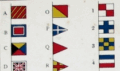 | Details | His Majesty's Stationery Office | 1908 |
| Signal Card 1908 |
|
His Majesty's Stationery Office |
|
| 1908 |
| LOC:41 |
| $95.00 | His-Majesty-s-Stationery-Office | Signal-Card-1908 | Small 4-page lithographed publication on 3 bound, heavy cards detailing signals used by Britain's naval forces: signal flags and pendants, semaphore, Morse signs, and flashing signs. HMSO, a commercial entity operated by the British government, was founded in 1786 to reduce costs by consolidating printing for the empire. Printed by M’Lagan and Cumming, Edinburgh. Price three pence. |