| | Thumbnail | | Creator | Date | Title / Author / Date / Location | Price | | | Description |
| 3633 | 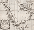 | Details | Bellin, Jacques Nicolas | 1740 |
| Nice French antique map of Saudi Arabia, Red Sea, Persian Gulf |
|
Bellin, Jacques Nicolas |
|
| 1740 |
| LOC:6 |
| $320.00 | Bellin--Jacques-Nicolas | Nice-French-antique-map-of-Saudi-Arabia--Red-Sea--Persian-Gulf | Striking and beautifully engraved map of Arabia, the Red Sea, and the Persian Gulf. Decorative compass rose and scroll-work title cartouche. The area shown on this fine original map is currently territory of these states: Saudi Arabia, Egypt, Israel, Jordan, Iraq, Iran, United Arab Emirates, Yemen, Oman and more.
<br></br>
Published by Jacques Bellin by order of the Count de Maurepas (Jean-Frédéric Phélypeaux 1701-1781) who served as France's Minister of Marine from 1723-1749. By his recommendations to Louis XVI delaying economic and administrative reforms, Maurepas was partially responsible for the governmental crises that led to the French Revolution.
<br></br>
French hydrographer Jacques Nicolas Bellin (1703-1772) was born in Paris and educated as an engineer. In 1741, Bellin became the first Ingénieur de la Marine of the Depot des cartes et plans de la Marine (the French Hydrographical Office) and was named Official Hydrographer of the French King. Bellin's largest and most comprehensive work is the Petit Atlas Maritime that covered the coasts and important port cities of the known world. |
| 1057 | 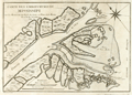 | Details | Bellin, Jacques Nicolas | 1744 |
| Antique chart of the mouth of the Mississippi River |
|
Bellin, Jacques Nicolas |
|
| 1744 |
| LOC:3 |
| $460.00 | Bellin--Jacques-Nicolas | Antique-chart-of-the-mouth-of-the-Mississippi-River | One of the earliest available charts to focus solely on the passes at the mouth of the Mississippi River, then considered by the French to be their overseas possession. The location covered by this chart lies roughly 75 miles southeast of New Orleans, Louisiana which had only been founded in 1718 by the French Mississippi Company, under the leadership of Jean-Baptiste Le Moyne de Bienville.
<br></br>
This is the first and earliest of two small charts by the Depot de la Marine; the later chart appeared in Bellin's 1764 "Le Petit Atlas Maritime". This chart is characterized by numerous descriptions of the hydrography ("recif" or reef; "bancs de vase molle" or soft mudflats; and "le bare") but contains no depth soundings. The southwest pass is particularly interesting for it is labeled "Embouchure par ou les vaisseau entrant" or mouth where vessels enter. Just inside the mouth near two reefs a small ship is depicted aground ("V[aisse]au Echoué"). Further up the channel ("Chenal") is Fort de la Balise (Fr. seamark). At that spot the French constructed a 62 foot high pyramidal wooden tower (the Balise) in 1721.
<br></br>
This chart was undoubtedly based on observations prior to 1740 when the Balise was destroyed by a hurricance. Bellin's later 1764 chart shows no structure at that location, just a mass of debris. |
| 760 | 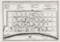 | Details | Bellin, Jacques Nicolas | 1744 |
| Plan of New Orleans French Quarter German ed. |
|
Bellin, Jacques Nicolas |
|
| 1744 |
| LOC:3 |
| $0.00 | Bellin--Jacques-Nicolas | Plan-of-New-Orleans-French-Quarter-German-ed- | SOLD<BR> </BR>
German edition of J.N. Bellin's well-known plan of the city of New Orleans, based on a manuscript document created approximately 15 years after the city was founded along high ground on the east bank of the Mississippi river. This plan from New Orlean's French colonial period, shows the city neatly laid out with streets most residents would recognize today as the French Quarter.
<BR> </BR>
The plan is based on a design initially created by military engineers Adrien de Pauger and Le Blond de la Tour in 1722. That plan envisoned a street grid extending six blocks northward from the Mississippi River, a plan that was likely scaled back in 1729 as a result of the Natchez Indian massacre of settlers at Fort Rosalie near Natchez Mississippi. At that point security became paramount. This plan by Bellin is more similar to an unsigned manuscript plan of New Orleans from 1732, which showed the city extending only 4 blocks north from the river, and partially surrounded by a defensive moat. The new emphasis on security, when the population totaled less than 2000 persons, is reflected in some of the other features found in Bellin's plan: guardhouses, a powder magazine, and a single bridge controlling access across the moat to the city. Those features were absent in Pauger's plan.
<br></br>
This plan was probably published in a German edition of Charlevoix's 'History and General Description of New France' which was originally published in French from Paris during 1744. (Source: Lemmon, Alfred E., John T Magill, and Jason R. Wiese. Charting Louisiana. The Historic New Orleans Collection. 2003).
<br></br><hr>
<a style="color:#0000EE" rel="nofollow" href= "https://www.rarecharts.com/ShowDetail/Creator/Tirion--Isaac/Title/Maps-of-French-Colonial-New-Orleans-and-the-Mississippi-River/1069">View this similar, larger map by Isaac Tirion from 1769.<br><br/>
<img src="http://www.rarecharts.com/ZoomifyImages/SC_1069/TN.gif"/> </a><BR> </BR><hr> |
| 2488 | 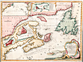 | Details | Bellin, Jacques Nicolas | 1744 |
| Fine decorative chart of eastern Canada |
|
Bellin, Jacques Nicolas |
|
| 1744 |
| LOC:0 |
| $0.00 | Bellin--Jacques-Nicolas | Fine-decorative-chart-of-eastern-Canada | SOLD
<br></br>
Bellin's attractive map of New England and eastern Canada. With insets of the fortified town of Quebec, Fort Dauphin, the city and Port of Louisbourg, and the eastern United States and Canada from Cape Fear northward. The map includes New England as far south as Boston, the St. Lawrence River just beyond Quebec, and north to Cape Round. Very attractive title cartouche with ships and land batteries firing cannon.
<br></br>
Prince Edward Island, one of Canada's three maritime provinces, is labeled "St. Johns" after the original French name "Île Saint-Jean". The island is named for Prince Edward, Duke of Kent, the fourth son of King George III.
<br></br>
Coastal detail features soundings and the fishing banks. This attractive map of Canada was published by N. Bellin in 1744. |
| 1159 | 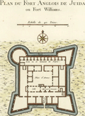 | Details | Bellin, Jacques Nicolas | 1747 |
| Plan du Fort Anglois de Juida |
|
Bellin, Jacques Nicolas |
|
| 1747 |
| LOC:0 |
| $0.00 | Bellin--Jacques-Nicolas | Plan-du-Fort-Anglois-de-Juida | SOLD
<br><br/>
French antique engraved plan from 1747 of Fort Williams, the English <b>"slave fort"</b> at "Juida" (Ouidah or Whydah) in the Kingdom of Dahomey, now the Republic of Benin, Africa.
<br></br>
The general layout of the lower fort is instructive. The layout defines a central square- the Place d'Armes"; large apartments and at the back of the fort lie fourteen small, windowless, <b>cramped holding cells</b> labeled "Lieu ou se tiennent les Negres" for the slaves in transit.
<br></br>
Fort Williams was <b>trans-shipment point</b> for cargoes of slaves shipped from the fort to points west including the West Indies, North and South America. For defense, the fort provided three triangular bastions and one circular bastion that could mount up to nineteen cannon.
<br></br>
From Prevost's 'Histoire Generale des Voyages'. Tome IV No.11. |
| 3639 |  | Details | Bellin, Jacques Nicolas | 1747 |
| Scarce antique map of the Mississippi River |
|
Bellin, Jacques Nicolas |
|
| 1747 |
| LOC:10 |
| $800.00 | Bellin--Jacques-Nicolas | Scarce-antique-map-of-the-Mississippi-River | Bellin's fine map from 1747 focusing on the Red River and the Mississippi River. Full of interesting notes (in French) about the rivers, habitations, and native American tribes. Includes an inset of the area surrounding Fort St. Jean [Baptiste] a military post on the Red River in Natchitoches, Louisiana (founded by French Canadians in 1716). Shows the channel upstream of the fort was partially dammed by a tangle of uprooted trees.
<br></br>
Coverage extends southward along the Mississippi River almost as far as Baton Rouge.
<br></br>
French hydrographer Jacques Nicolas Bellin (1703-1772) was born in Paris and educated as an engineer. In 1741, Bellin became the first Ingénieur de la Marine of the Depot des cartes et plans de la Marine (the French Hydrographical Office) and was named Official Hydrographer of the French King. Bellin's largest and most comprehensive work is the Petit Atlas Maritime that covered the coasts and important port cities of the known world. |
| 20 |  | Details | Bellin, Jacques Nicolas | 1750 |
| Carte Generale De La Coste De Guinee |
|
Bellin, Jacques Nicolas |
|
| 1750 |
| LOC:0 |
| $395.00 | Bellin--Jacques-Nicolas | Carte-Generale-De-La-Coste-De-Guinee | Large working antique nautical chart of African coast focusing on the Gulf of Guinea and Gulf of Benin. Six profile views of the coast of West Africa, just north of the equator. This chart was intended for service aboard French vessels as noted in the cartouche "Pour servir aux vaisseaux du Roy".<BR> </BR>
Large central cartouche framed by strapwork and floral flourishes. This nautical chart was published less than 40 years after the death of Louis XIV, the "sun king" by the Depot des Cartes et Plans de la Marine. |
| 4857 |  | Details | Bellin, Jacques Nicolas | 1750 |
| Antique engraved plan of Goa, India |
|
Bellin, Jacques Nicolas |
|
| 1750 |
| LOC:13 |
| $325.00 | Bellin--Jacques-Nicolas | Antique-engraved-plan-of-Goa--India | Fine mid eighteenth-century birds-eye view map (plan) of Goa and the Port of Goa, on the southwest coast of India, under Portuguese rule from 1510 to 1961. If you look carefully on the beach you can see two elephants, apparently used for heavy work at the docks and shipyard. A fine legend at right, in an elaborate title cartouche, names twenty-nine locations on the plan.
<br></br>
A fine view of Goa as it existed in 1607 by the prolific desk-cartographer J.N. Bellin. The plan is from the 1607 voyage of Admiral Paulus van Caerden, with the Dutch East India Company (VOC). From Prevost's 'Collection of Voyages'.
<br></br>
North is oriented to the bottom. Tome VIII No IX.
<br></br>
French hydrographer Jacques Nicolas Bellin (1703-1772) was born in Paris and educated as an engineer. In 1741, Bellin became the first Ingénieur de la Marine of the Depot des cartes et plans de la Marine (the French Hydrographical Office) and was named Official Hydrographer of the French King. Bellin's largest and most comprehensive work is the "Petit Atlas Maritime Recueil De Cartes et Plans Des Quatre Parties Du Monde Petit Atlas Maritime". |
| 4701 | 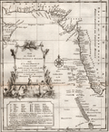 | Details | Bellin, Jacques Nicolas | 1750 |
| Antique map with Iran, India, and Yemen |
|
Bellin, Jacques Nicolas |
|
| 1750 |
| LOC:13 |
| $180.00 | Bellin--Jacques-Nicolas | Antique-map-with-Iran--India--and-Yemen | Attractive and highly decorative antique map of the Malabar coast of India, the Arabian Sea, and the coasts of Yemen, Iran, and Pakistan. Includes a good depiction of the Maldive Islands and the Laccadive Islands. Numerous noted locations include Surat, Bombay (Mumbai), Rajapor, Goa, Kalikoet (Calicut, now Kozhikode), Madura, and Cape Comorin.
<br></br>
Graphic title cartouche features a seahorse and a merman, with dragonfly-winged heads above. Legend at bottom left contains Dutch translations of many French geographical terms.
<br></br>
Re-engraved by von Schley after a French map by J.N. Bellin and published in Amsterdam in a Dutch edition of L'Histoire Generale des Voyages. Dutch title at bottom reads "Kaart van de Kusten van Persie, Guzaratte en Malabar…" |
| 4702 | 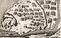 | Details | Bellin, Jacques Nicolas | 1750 |
| Antique plan of Diu Island, India |
|
Bellin, Jacques Nicolas |
|
| 1750 |
| LOC:13 |
| $155.00 | Bellin--Jacques-Nicolas | Antique-plan-of-Diu-Island--India | Antique plan of Diu Island and the Portuguese fortress at Diu, in Gujarat province, India. Includes St. Paul church, a mosque, and several defensive positions.
<br></br>
Shows the port and fortification of Diu once called the "Gibraltar of the East', with the hospital, the church of St. Paul and St. Jago. The fortification was the site of the Battle of Diu in 1509 between Portugal and a fleet of ships of the Ottoman, Egyptian, Venetian, allies of the Sultan of Gujarat, Mahmud Begada. Diu remained in possession of the Portuguese from 1535 until 1961, when it fell to troops of the Indian Union.
<br></br>
Re-engraved by von Schley after a French view by J.N. Bellin and published in Amsterdam in a Dutch edition of L'Histoire Generale des Voyages. Verso is blank. |
| 402 |  | Details | Bellin, Jacques Nicolas | 1750 |
| Macao |
|
Bellin, Jacques Nicolas |
|
| 1750 |
| LOC:6 |
| $180.00 | Bellin--Jacques-Nicolas | Macao | Early chart of the port of Macao, China by Bellin ca. 1750. |
| 403 |  | Details | Bellin, Jacques Nicolas | 1752 |
| Philippines |
|
Bellin, Jacques Nicolas |
|
| 1752 |
| LOC:0 |
| $0.00 | Bellin--Jacques-Nicolas | Philippines | SOLD<br></br>Early map of the Philippines Islands by Bellin after Velarde . Dated 1752 in cartouche |
| 99 | 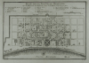 | Details | Bellin, Jacques Nicolas | 1753 |
| Plan de la Nouvelle Orleans - SOLD |
|
Bellin, Jacques Nicolas |
|
| 1753 |
| LOC:0 |
| $0.00 | Bellin--Jacques-Nicolas | Plan-de-la-Nouvelle-Orleans---SOLD | <BR></BR>
This plate has been SOLD but please see another <a style="color:#0000EE" rel="nofollow" href="https://www.rarecharts.com/ShowDetail/Creator/Bellin--Jacques-Nicolas/Title/Plan-de-la-Nouvelle-Orleans-(3)/1193">hand-colored engraving of Bellin's plan.</a>
<br><br/>
Bellin's famous plan of the city of New Orleans, based on a manuscript map created approximately 25 years after the city was founded along high ground on the east bank of the Mississippi river. Shows the city neatly laid out with streets most residents would recognize today including Bourbon, Chartres, Royale and at the center of the plan- Jackson Square. Number 19.<BR> </BR>
Interestingly, what appears to be a defensive wall around the city is labeled "fosse' plein d'eau". Fosse' is French for "canal". Therefore, even at this relatively early point in its history New Orleans had a canal originating in the vicinity of today's Canal Street. |
| 864 | 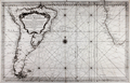 | Details | Bellin, Jacques Nicolas | 1753 |
| Carte Reduite de l'Ocean Meridional |
|
Bellin, Jacques Nicolas |
|
| 1753 |
| LOC:51 |
| $555.00 | Bellin--Jacques-Nicolas | Carte-Reduite-de-l-Ocean-Meridional | Antique French nautical chart of the southern Atlantic Ocean with most of the South American continent and southwest Africa. Features the full extent of the Amazon River, likely based on the exploration by French explorer Charles Marie de La Condamine. Condamine led the first scientific exploration of the Amazon River in 1743, publishing his results with a map of the Amazon in the memoirs of the French Académie des Sciences in 1745. Large decorative title cartouche dedicates the chart to M. Rouille, Minister and Sceretary of State to the French Department de Marine.
<br></br>
The Falkland Islands, off the east coast of Patagonia, are described as "Isle Nouvelles". In this chart East and West Falkland Islands are conjoined and the far west coastline is not defined. This reflects the fact that the island group was not discovered until 1690 and the town of Port Louis was not settled until Louis de Bougainville established it as the first French settlement on the island in 1764.
<br></br>
Published by Bellin with the title of "Ingeneur de la Marine" from Paris at "Rue de Doyenne pre la Rue St. Thomas du Louvre". At that time although Bellin had a relationship with the French Depot de la Marine he also published charts privately under his own name. |
| 1295 | 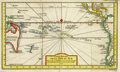 | Details | Bellin, Jacques Nicolas | 1753 |
| Antique South Pacific map with oddly-shaped Australia |
|
Bellin, Jacques Nicolas |
|
| 1753 |
| LOC:6 |
| $600.00 | Bellin--Jacques-Nicolas | Antique-South-Pacific-map-with-oddly-shaped-Australia | Fine 18th-century antique French map of the South Pacific showing recent discoveries as of mid century: Australia's posited eastern coastline is virtually featureless, running from New Guinea to Tasmania without a break. Only a small section of the western coast New Zealand is marked, the rest unknown. The Americas are shown from Baja California through Central America and the western coastline of South America including the Straits of Magellan and Cape Horn.
<br></br>
Published in a French edition of L'Abbe Prevost's "Histoire Générale des Voyages", less than twenty years before Captain Cook's famous voyage. |
| 2533 | 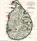 | Details | Bellin, Jacques Nicolas | 1753 |
| Antique Map of Sri Lanka |
|
Bellin, Jacques Nicolas |
|
| 1753 |
| LOC:6 |
| $350.00 | Bellin--Jacques-Nicolas | Antique-Map-of-Sri-Lanka | A fine antique map Sri Lanka (Ceylon or Ceylan), an island country in South Asia, located to the southwest of the Bay of Bengal and to the southeast of the Arabian Sea. Sri Lanka is separated from the Indian subcontinent by the Gulf of Mannar and the Palk Strait. Historically, Sri Lanka's geographic location and deep harbours made it of great strategic importance from the time of the ancient Silk Road through to the modern Maritime Silk Road.
<br></br>
Published in a French edition of L'Abbe Prevost's "Histoire Générale des Voyages", less than twenty years before Captain Cook's famous voyage. |
| 591 | 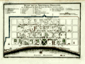 | Details | Bellin, Jacques Nicolas | 1753 |
| Plan de la Nouvelle Orleans |
|
Bellin, Jacques Nicolas |
|
| 1753 |
| LOC:0 |
| $0.00 | Bellin--Jacques-Nicolas | Plan-de-la-Nouvelle-Orleans | <BR></BR>
This plate has been SOLD but please see another <a style="color:#0000EE" rel="nofollow" href="https://www.rarecharts.com/ShowDetail/Creator/Bellin--Jacques-Nicolas/Title/Plan-de-la-Nouvelle-Orleans-(3)/1193">hand-colored engraving of Bellin's plan.</a>
<br><br/>
J.N. Bellin's early plan of the city of New Orleans, Louisiana. |
| 1193 | 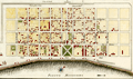 | Details | Bellin, Jacques Nicolas | 1753 |
| Plan de la Nouvelle Orleans (3) |
|
Bellin, Jacques Nicolas |
|
| 1753 |
| LOC:3 |
| $700.00 | Bellin--Jacques-Nicolas | Plan-de-la-Nouvelle-Orleans-(3) | Antique French plan of the city of New Orleans, Louisiana ("la Nouvelle Orleans") from the period of French colonization ca. 1753. This antique city plan of New Orleans was based on a manuscript map created approximately 25 years after the city was founded on the east bank of the Mississippi river. This neat hand-colored, copper-plate engraved map shows the city laid out with French Quarter streets most residents would recognize today including Bienville, Bourbon, Chartres, Royale and at the center of the plan- Jackson Square. Note the spelling of Mississippi below the town with one "P" as "Fleuve Mississipi".
<BR> </BR>
Nineteen key points within the city are keyed to a legend on the map just below the title. These key points within early New Orleans include:
<div class="indenttextblock">
<ul style="list-style-type: circle;">
<li>Prisons</li>
<li>Place d'Armes (today's Jackson Square)</li>
<li> l'Eglise Paroissiale (parish church)</li>
<li>Poudriere (powder magazine)</li>
<li>Magasins du Roi (Royal stores)</li>
<li>Nouvelle Maison du Urselines (or new home for the Ursuline nuns, an important force in early New Orleans)</li>
<li>Forges du Roi (the King's forge or metalworking shop)</li>
<li>Moulin a vent et a Cheval (a mill operated by the wind and horse )</li>
</ul>
</div>
Interestingly, what appears to be a defensive wall around the city is labeled "fosse' plein d'eau". Fosse' is French for "canal". Therefore, even at this relatively early point in its history New Orleans, Louisiana had a canal originating in the vicinity of today's Canal Street. An opening for a gate labeled "St. Jean" would have allowed access to a road leading to Bayou St. John, then an important route to points East. Plate number 19. |
| 1415 | 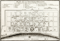 | Details | Bellin, Jacques Nicolas | 1753 |
| Antique Colonial-era Plan of the French Quarter in New Orleans, Louisiana |
|
Bellin, Jacques Nicolas |
|
| 1753 |
| LOC:3 |
| $600.00 | Bellin--Jacques-Nicolas | Antique-Colonial-era-Plan-of-the-French-Quarter-in-New-Orleans--Louisiana | Antique French plan of the city of New Orleans, Louisiana ("la Nouvelle Orleans") from the period of French colonization ca. 1753. This antique city plan of New Orleans by Nicolas Bellin was based on a manuscript map created by Pauger approximately 15 years after the city was founded on the east bank of the Mississippi river.
<BR> </BR>
Bellin's plan shows the city laid out with French Quarter streets most residents would recognize today including Bienville, Bourbon, Chartres, Royale and at the center of the plan- Jackson Square. Note the spelling of the Mississippi River below the town with one "P" as "Fleuve Mississipi".
<BR> </BR>
On this old uncolored, copper-plate engraved map nineteen key points within the city are keyed to a legend on the map just below the title. These important locations within early New Orleans include:
<div class="indenttextblock">
<ul style="list-style-type: circle;">
<li>Prisons</li>
<li>Place d'Armes (today's Jackson Square)</li>
<li> l'Eglise Paroissiale (parish church)</li>
<li>Poudriere (powder magazine)</li>
<li>Magasins du Roi (Royal stores)</li>
<li>Nouvelle Maison du Urselines (or new home for the Ursuline nuns, an important force in early New Orleans)</li>
<li>Forges du Roi (the King's forge or metalworking shop)</li>
<li>Moulin a vent et a Cheval (a mill operated by the wind and horse )</li>
</ul>
</div>
The plan is based on a design initially created by military engineers Adrien de Pauger and Le Blond de la Tour in 1722. That plan envisoned a street grid extending six blocks northward from the Mississippi River, a plan that was likely scaled back in 1729 as a result of the Natchez Indian massacre of settlers at Fort Rosalie near Natchez Mississippi. At that point security became paramount, reflected in some of the other features found in Bellin's plan: guardhouses, a powder magazine, and a single bridge controlling access across the moat to the city. Plate number 19. |
| 1395 | 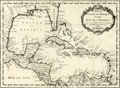 | Details | Bellin, Jacques Nicolas | 1754 |
| Gulf of Mexico and Caribbean Antique Original Map |
|
Bellin, Jacques Nicolas |
|
| 1754 |
| LOC:0 |
| $0.00 | Bellin--Jacques-Nicolas | Gulf-of-Mexico-and-Caribbean-Antique-Original-Map | SOLD<br></br>
Original mid 18th-century French map of the Texas, Louisiana, Alabama, Florida, coastline with the Gulf of Mexico, Central America, Caribbean islands and Antilles.
<br></br>
Framed, glazed, and double matted. Size with frame 20" x 17".
<br></br>
This original antique map by Nicolas Bellin contains the tracks of explorers including Cortez, Ponce de leon, and the lesser-known Francisco Hernández de Córdoba, an early explorer of Mexco's Yucatan peninsula.
<br></br>
Published in a French edition of L'Abbe Prevost's "Histoire Générale des Voyages". Tome 12, No. 1. |
| 1396 | 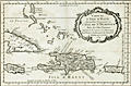 | Details | Bellin, Jacques Nicolas | 1754 |
| Caribbean Antique Map with Hispaniola (Hayti), Porto Rico, Jamaica |
|
Bellin, Jacques Nicolas |
|
| 1754 |
| LOC:0 |
| $285.00 | Bellin--Jacques-Nicolas | Caribbean-Antique-Map-with-Hispaniola-(Hayti)--Porto-Rico--Jamaica | Matted and framed.
<br></br>
Original mid 18th-century French map of Caribbean islands centered on the island of Hispaniola with Haiti and Santo Domingo by Nicolas Bellin. The island of Hayti ( Haiti ) is shown divided into the five pre-Columbian cacicazgos, or Taino kingdoms. Puerto Rico is named I. Boriquen or S. Jean Baptiste. Nearly all of Jamaica is shown, as well as the eastern half of Cuba, the Turks and Caicos islands, and the Bahamas as far north as Cat Island.
<br></br>
Size with frame 18" x 15".
<br></br>
Published in a French edition of L'Abbe Prevost's "Histoire Générale des Voyages". Tome 12, No. 1. |
| 1195 | 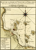 | Details | Bellin, Jacques Nicolas | 1754 |
| Plan de la Rade et Ville de la Veracruz, Mexico. |
|
Bellin, Jacques Nicolas |
|
| 1754 |
| LOC:0 |
| $0.00 | Bellin--Jacques-Nicolas | Plan-de-la-Rade-et-Ville-de-la-Veracruz--Mexico- | SOLD<br></br>One of the earliest available port plans of Veracruz, Mexico, the harbor of Veracruz and nearby islands. Notations of numerous depth soundings, sandbanks (ex: Banc de Roches; le Banc Forain; le Grand Banc de Roches) , and an anchorage attest to the nautical heritage of this small antique French port plan. From the 15-volume "Histoire Generale des Voyages" of Antoine François Prévost published from Paris in 1754. Tome XII. Number 7.
<br></br>
It was on the island of San Juan de Ulúa that Spanish captain Juan de Grijalva first arrived in 1518, along with conquistador and author Bernal Díaz del Castillo ("The True History of the Conquest of New Spain"). That island was also the scene of a battle in 1569 between the Spanish Navy and a fleet led by John Hawkins that included Francis Drake. The treachery that the English perceived on the part of Spain at that battle helped to fuel antagonism between the two powers for many decades.
<br></br>
In Veracruz several key points are identified on a legend at bottom right including:
<div class="indenttextblock">
<ul style="list-style-type: circle;">
<li>La Grande Eglise</li>
<li>L 'Inquisition</li>
<li>Les Jesuits</li>
<li>Maison de Gouverneur </li>
<li>La Douane (the customs house)</li>
<li>Maison de Compagnie de l'Assiente</li>
<li>Les Augustins</li>
</ul>
</div> |
| 1401 | 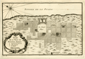 | Details | Bellin, Jacques Nicolas | 1754 |
| Antique plan of Buenos Aires, Argentina |
|
Bellin, Jacques Nicolas |
|
| 1754 |
| LOC:5 |
| $200.00 | Bellin--Jacques-Nicolas | Antique-plan-of-Buenos-Aires--Argentina | Early French map or plan of Buenos Aires, Argentina along the western shore of the estuary of the Plate River (Rio de la Plata) in South America. By important French cartographer Nicolas Bellin. North is oriented to the upper left. Named features on this early colonial-period map include:
<div class="indenttextblock">
<ul style="list-style-type: circle;">
<li>Maison de Ville</li>
<li>Le Fort containing the governor's lodgings, the chapel, and guard's quarters.</li>
<li>Convent de la Merci</li>
<li>l'Hopital</li>
<li>Convent de S. Domingue</li>
<li>Maison des Jesuites</li>
<li>Maison de l'Eveque</li>
<li>Eglise de St. Jean hors de la Ville</li>
</ul>
</div>
Published in a French edition of L'Abbe Prevost's "Histoire Générale des Voyages". Tome 14, No. 2. |
| 3659 | 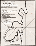 | Details | Bellin, Jacques Nicolas | 1754 |
| Antique port plan of Acapulco, Mexico |
|
Bellin, Jacques Nicolas |
|
| 1754 |
| LOC:77 |
| $185.00 | Bellin--Jacques-Nicolas | Antique-port-plan-of-Acapulco--Mexico | J.N. Bellin's neat antique plan of the walled fort, port and harbor at Acapulco, Mexico. Includes a French-language key to fourteen principal locations on the plan including Fort San Diego with 100 pieces of cannon, four new bastions lining the bay, and on the south side of the bay- two trees where the Manilla Galleon attaches a cable (rope) for mooring.
<br></br>
North is oriented to the left. Page 195. |
| 1367 | 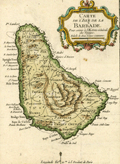 | Details | Bellin, Jacques Nicolas | 1754 |
| Small antique map of Barbados in the Caribbean |
|
Bellin, Jacques Nicolas |
|
| 1754 |
| LOC:0 |
| $0.00 | Bellin--Jacques-Nicolas | Small-antique-map-of-Barbados-in-the-Caribbean | SOLD <br></br>
Small antique map of Barbados by J.N. Bellin. This hand-colored map shows the island of Barbados, a Caribbean island in the Lesser Antilles. Barbados was an English colony at the time this little map was printed. Depicts the capital city of Barbados- Bridgetown as well as many other towns, island parishes and attractive interior topographic detail.
<br></br>
Published in the 15-volume "Histoire Generale des Voyages" of Antoine François Prévost. Published from Paris in 1754. Tome 15. Page 567. |
| 1402 | 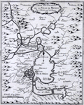 | Details | Bellin, Jacques Nicolas | 1754 |
| Antique Pre-Columbian Plan of Mexico City |
|
Bellin, Jacques Nicolas |
|
| 1754 |
| LOC: |
| $300.00 | Bellin--Jacques-Nicolas | Antique-Pre-Columbian-Plan-of-Mexico-City | Early French map of the Valley of Mexico and Mexico City. Shows Mexico City or Tenochtitlán, the island capital of the Aztec state, as it was when encountered by Spanish conquistador Hernán Cortés in 1521. In the copper-plate engraved image Tenochtitlán is located near the southwest end of the "Lac de Mexico" or Lake Texcoco. Tenochtitlán was connected to the Valley of Mexico via several causeways. Includes the larger cities of Pachuca, Tezcuco, Chalco. No mention of Teotihuacan. By French cartographer Nicolas Bellin.
<br></br>
Framed and matted meaures 12" W x 14" H.
<br></br>
Tenochtitlan was largely destroyed by Cortés after a siege in 1521, and modern-day Mexico City now lies over much of its remains.
<br></br>
Published in a French edition of L'Abbe Prevost's "Histoire Générale des Voyages". Tome 12, No. 10. |
| 1403 | 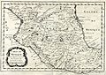 | Details | Bellin, Jacques Nicolas | 1754 |
| Antique Map of Central Mexico |
|
Bellin, Jacques Nicolas |
|
| 1754 |
| LOC:0 |
| $0.00 | Bellin--Jacques-Nicolas | Antique-Map-of-Central-Mexico | Not available
<BR></BR>
Original mid 18th-century French map of the Central Mexico region. This early cartographic artifact covers an area from roughly south of Durango to a line north of Acapulco. In all, a fine copperplate-engraved antique map of Mexico by N. Bellin that includes the towns of "Mazatland" (Mazatlan), "Guadalaxara" (Guadalajara), Zacatecas, Veracruz, "Mechoacan", and many more. Shows mountains in relief, many rivers, and small villages. Dated within an elaborate cartouche to 1754.
<br></br>
Framed, glazed, and double matted. Size with frame 18.5" x 15".
<br></br>
Published in a French edition of L'Abbe Prevost's "Histoire Générale des Voyages". Tome 12, No. 8. |
| 5213 | 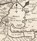 | Details | Bellin, Jacques Nicolas | 1754 |
| Antique plan of Mexico City with Lake Texcoco Cortez Moctezuma |
|
Bellin, Jacques Nicolas |
|
| 1754 |
| LOC:77 |
| $250.00 | Bellin--Jacques-Nicolas | Antique-plan-of-Mexico-City-with-Lake-Texcoco-Cortez-Moctezuma | Original engraved French map of the Valley of Mexico and Mexico City as it was when encountered by Spanish conquistador Hernán Cortés in 1521. Shows Mexico City or Tenochtitlán, the island capital of the Aztec state. In this copper-plate engraved image Tenochtitlán is located near the southwest end of the "Lac de Mexico" or Lake Texcoco. Tenochtitlán was connected to the Valley of Mexico via several causeways. Includes the larger cities of Pachuca, Tezcuco, Chalco. Tenochtitlan was largely destroyed by Cortés after a siege in 1521, and modern-day Mexico City now lies over much of its remains.
<br></br>
By Jacques Bellin. Published in a French edition of L'Abbe Prevost's "Histoire Générale des Voyages". Tome 2 No. 5. |
| 785 |  | Details | Bellin, Jacques Nicolas | 1756 |
| Antique chart of Lisbon and Setubal, Portugal with the Tagus River |
|
Bellin, Jacques Nicolas |
|
| 1756 |
| LOC:57 |
| $1,600.00 | Bellin--Jacques-Nicolas | Antique-chart-of-Lisbon-and-Setubal--Portugal-with-the-Tagus-River | Beautiful, antique plan and chart of the Tagus River, Lisbon, Portugal and surrounding area. At the top the entire width of this scarce nautical chart contains a detailed panoramic profile view of Lisbon ( Lisbonne ) westward past Belem as it existed in the mid-eighteenth century with the core city surrounded by walls. Would make a fine gift for anyone with an interest in boating or other maritime activities in the area of Lisbon, Portugal.
<br></br>
At that time the size of the city was much smaller than today- Belem ( Bourg de Belem ) and the Tower of Belém ( Tour de Belem ) are far outside the city walls. An inset plan below the decorative title cartouche shows detailed information about Lisbon and an explanatory legend. These important feature include : le Chateau; la Palais du Roy; the customs house- la Douane; and a major shipyard - Chantier pour la construction des Vaisseaux. Coverage includes several areas that are popular today with tourists including Sintra ( Cintra ), and Cascais, on the Atlantic coast near Cabo de la Roca.
<br></br>
Numerous geographical and topographical features including: Setubal, Colares, Fort St. Antoine, Fort de St. Julien, Village de Passe d'Arc', the convent of Notre Dame de Bon Voyages, Sacaven, Port Brandan, Fort de Bougie, Romeira, Cap Spichel, Sezimbre, and Fort St. Philippe.
<br></br>
With rhumb lines and an attractive compass rose with an adjustment for magnetic variation. As expected on a sea chart there are numerous soundings, anchorages, and hazards including several long reefs off the mouth of the Tagus River. Published by J.N. Bellin for France's Depot de La Marine. |
| 1083 | 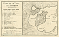 | Details | Bellin, Jacques Nicolas | 1757 |
| Antique French Map and Plan of Boston, Massachusetts |
|
Bellin, Jacques Nicolas |
|
| 1757 |
| LOC:0 |
| $0.00 | Bellin--Jacques-Nicolas | Antique-French-Map-and-Plan-of-Boston--Massachusetts | SOLD
<br></br>
One of the earliest obtainable town plans of <b>Boston, Massachusetts</b>. This antique French plan shows the area as it was 12 years before the American Revolutionary War. This fine copper-plate engraved plan from Bellin's Histoire General des Voyages shows the <b>back bay</b> as a true bay, before it was filled and built up in the 19th century. Includes <b>Charles Town</b> across the bay.
<br></br>
In Boston Bay the key features are an anchorage, Ronde Island, and a single dotted line denoting the navigational channel. Very sparse soundings and hydrographic details. Includes at left an index of 16 locations identified alphabetically on the map.
</br>
<b> These 16 key locations include:</b>
<div class="indenttextblock">
<ul>
<span style="list-style-type: circle;">
<li>2 batterys, each with 25 pieces of cannon </li>
<li> Two Presbyterian churches</li>
<li>A Quaker church </li>
<li>An Anabaptist church</li>
<li>The armory</li>
<li>A wharf </li>
<li>The powder magazine </li>
<li> A "Petit Bassin qui asseche de basse mer" (the Back Bay area)</li>
<li> The fortified and defended city gate</li>
</span>
</ul>
</div> |
| 870 | 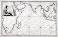 | Details | Bellin, Jacques Nicolas | 1757 |
| French sea chart of the Indian Ocean with Australia |
|
Bellin, Jacques Nicolas |
|
| 1757 |
| LOC:0 |
| $0.00 | Bellin--Jacques-Nicolas | French-sea-chart-of-the-Indian-Ocean-with-Australia | SOLD
<br></br>
Attractive antique French sea chart of the Indian Ocean with Australia, the southern half of Africa, Madagascar, Reunion Island ( "Île Bourbon" ), the Red Sea, Saudi Arabia and the Persian Gulf, India, Malaysia, Indonesia, the Philipines, and Taiwan. Key cities on this 1757 nautical chart include Macao, Manilla, Jakarta ( "Batavia" ), Mumbai ( "Bombay" ), Mecca ( "la Meque" ), and Cape Town.
<br></br>
Bellin's depiction of the west coast of of Australia ("Terres Australes" or "Nouvelle Hollande") is worth a few words. At the time the chart was produced in the mid-eighteenth century much the Australian coastline was poorly charted. The coast of Australia was first sighted and charted by by Willem Janszoon aboard the Dutch vessel Duyfken in 1606. Later Dutch, French and English explorers including William Dampier added to the outline of west Australia, but there was still significant uncertainty about coastal detail and location. Bellin conveys this ambiguity by the use of a very light and often broken outline for most of the south and west coastline. Where Bellin felt more certainty, as on the north coast he used a bold engraved outline with hachured coastal relief to convey a sense of certitude. Bellin provides three notes referring to his sources. Translated from French they are roughly:
<div class="indenttextblock">
<ul>
<li>Terre de Concorde discovered in 1628., </li>
<li>Bay of Sea-Dogs ( "Chiens Marines" ) [or Shark Bay], viewed by Dampier in 1699. , and</li>
<li>Coast viewed by Mr. Duquesne in 1687.</li>
</ul></div>
Attractive title cartouche with palm trees and African animals including a crocodile, elephant, and lion. As stated in the title the chart was produced for use by the French Navy. Unlike many other French charts there is no price noted, substantiating the premise that this copy was not intended for public consumption. |
| 830 | 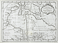 | Details | Bellin, Jacques Nicolas | 1757 |
| Antique French map of Hudson Bay |
|
Bellin, Jacques Nicolas |
|
| 1757 |
| LOC:0 |
| $0.00 | Bellin--Jacques-Nicolas | Antique-French-map-of-Hudson-Bay | SOLD<br></br>
Fascinating antique French map records Britain's dominions in the Northeast before the U.S. Revolutionary war. Coverage includes portions of the Canadian provinces of Nunavut, Manitoba, Ontario, and Quebec along with Hudson Bay, the second largest bay in the world after the Bay of Bengal. Noted features include Repulse Bay, James Bay, Labrador, the Isle de Bonne Fortune, Hudson Strait, and Cumberland Bay.
<br></br>
Along the shores of lower James Bay are several forts including Fort Albany, Fort de St. Louis, Fort Rupert. The bay is named after British explorer Henry Hudson who discovered the bay while searching for the Northwest Passsage under the auspices of the Virginia Company and the British East India Company. Hudson and a few of his men were set adrift and marooned in Hudson's Bay in June of 1611 by mutineers among the crew of his ship, the Discovery.
<br></br>
This map is from Bellin's Histoire Generale des Voyages. |
| 81 | 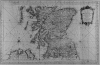 | Details | Bellin, Jacques Nicolas | 1757 |
| Isles Britanniques, Troisieme Feuille |
|
Bellin, Jacques Nicolas |
|
| 1757 |
| LOC:0 |
| $500.00 | Bellin--Jacques-Nicolas | Isles-Britanniques--Troisieme-Feuille | Impressive antique copperplate nautical chart of Scotland (Edinburgh), Firth of Forth, Aberdeen, Dundee, Glasgow, Firth of Clyde, the Irish Sea and Northern Ireland (Londonderry) on very thick wove paper. Published by J.N. Bellin of the Depot de la Marine in 1757. The antique chart contains a large, decorative, dated title cartouche in upper right. Single vertical fold as issued. |
| 83 | 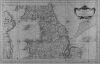 | Details | Bellin, Jacques Nicolas | 1757 |
| Isles Britanniques, Second Feuille |
|
Bellin, Jacques Nicolas |
|
| 1757 |
| LOC:0 |
| $510.00 | Bellin--Jacques-Nicolas | Isles-Britanniques--Second-Feuille | Impressive, large antique copperplate-engraved nautical chart of Wales (Isle of Anglesey), Northern Britain (Isle of Man, Yarmouth) , Scotland, and Eastern Ireland (Belfast, Dublin) on very thick wove paper. Published by J.N. Bellin of the Depot de la Marine in 1757. Single vertical fold as issued. Heavy impression. (Second sheet also available). |
| 2562 | 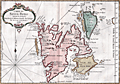 | Details | Bellin, Jacques Nicolas | 1758 |
| Antique French map of Spitsbergen, Norway |
|
Bellin, Jacques Nicolas |
|
| 1758 |
| LOC:88 |
| $270.00 | Bellin--Jacques-Nicolas | Antique-French-map-of-Spitsbergen--Norway | Fine 18th-century antique French map of Spits-berg (Spitsbergen), in today's Svalbard Islands - in northern Norway; the largest Norwegian island. One of the most northern regions to be discovered by Europeans, the place names seen here reflect the nationalities of those early travellers, English, Dutch, Scandinavian and French. Spitsbergen was first used as a whaling base in the 17th and 18th centuries.
<br></br>
The first known sighting of Spitsbergen by a European was by Willem Barentsz, who came across it in 1596 while searching for the Northern Sea Route.
<br></br>
Published in a French edition of L'Abbe Prevost's "Histoire Générale des Voyages", less than twenty years before Captain Cook's famous voyage. Page 192. Book 17. |
| 255 |  | Details | Bellin, Jacques Nicolas | 1759 |
| Carte du Comte de Kent et du Pas de Calais |
|
Bellin, Jacques Nicolas |
|
| 1759 |
| LOC:0 |
| $0.00 | Bellin--Jacques-Nicolas | Carte-du-Comte-de-Kent-et-du-Pas-de-Calais | SOLD
<BR> </BR>
Full colored old antique nautical chart produced by the Depot de la Marine in 1759. This chart, produced by J.N. Bellin, covers many areas of historical importance including the English Channel, and the Thames river as far as London, Dover, Calais, Beachy Head, Dunkirk. Good coverage of inland cities, towns, and road in England including New Haven. Croydon, Bromley, Deal, Sandwich, Rochester and many, many more. Numerous soundings and details of the sandbanks near Dover, Dunkirk, and the entrance to the Thames River. Highly decorative dated cartouche at bottom right. |
| 165 |  | Details | Bellin, Jacques Nicolas | 1759 |
| Carte de la Coste Occidentale d'Afrique |
|
Bellin, Jacques Nicolas |
|
| 1759 |
| LOC:6 |
| $110.00 | Bellin--Jacques-Nicolas | Carte-de-la-Coste-Occidentale-d-Afrique | Small chart of the African coast near the bay of Arguim (Arguin) from the Dutch version of Prevost's widely published history originally engraved by Bellin. This copperplate, engraved by J.V. Schley., shows the African coast with both French and Dutch place names. Highlights the island of Arguim which was the site of an important Portuguese trading post / slave fort from which as many as 1000 slaves may have been sold each year. |
| 1024 |  | Details | Bellin, Jacques Nicolas | 1760 |
| 1760 Nautical Chart of Grenada in the Caribbean Sea |
|
Bellin, Jacques Nicolas |
|
| 1760 |
| LOC:68 |
| $975.00 | Bellin--Jacques-Nicolas | 1760-Nautical-Chart-of-Grenada-in-the-Caribbean-Sea | Large antique French sea chart of the island of Grenada in the Carribbean Sea. Dated within the decorative title cartouche to 1760. Coverage includes several of the smaller islands and islets in the Grenadine's chain: Carriacou, Round Island (Isle Rond), l'Islet de la Tante, Islet de Levera, Islet de Mileu, Islet de Haut. By Jacques Bellin of the French Depot de la Marine.
<br></br>
This edition of Bellin's chart of Grenada lacks the circular logo of the Depot de la Marine at bottom right, the "No. 82" at top right, and the price. Contains an attractive inset elevation view of the approach to the north end of the island showing le Grison, l'Islet Rond, Islet de la Tante, la Pointe Percee, and Cape David.
<br></br>
Noted features of this large navigational chart include Cape David, Cape de la Grenade, Poine de la Grande Riviere, Pointe du Fort Jendy, Pointe des Salines, Piton (peak) de Levera, Sauteurs, the Bourg du Grand Marquis, Victoria, Gouyave, and the town of St. George ( Fort Royal ). Soundings and anchorages are shown for the vicinity of St. George's. |
| 672 |  | Details | Bellin, Jacques Nicolas | 1760 |
| Antique French Chart of the Caribbean Island of Grenada |
|
Bellin, Jacques Nicolas |
|
| 1760 |
| LOC:51 |
| $675.00 | Bellin--Jacques-Nicolas | Antique-French-Chart-of-the-Caribbean-Island-of-Grenada | Striking, original antique French sea chart of the Island of Grenada in the Carribbean Sea. Possibly the last official French chart of the island as Britain wrested Grenada from France in 1762 during the Seven Years' War. By J.N. Bellin of the French Depot de la Marine.
<br></br>
Coverage includes several of the smaller islands and islets in the Grenadine's chain: Carriacou, Round Island (Isle Rond), l'Islet de la Tante, Islet de Levera, Islet de Mileu, Islet de Haut. The chart is large and colorful and will display nicely.
<br></br>
Noted features of this large navigational chart include Cape David, Cape de la Grenade, Poine de la Grande Riviere, Pointe du Fort Jendy, Pointe des Salines, Piton (peak) de Levera, Sauteurs, the Bourg du Grand Marquis, Victoria, Gouyave, and the town of St. George ( Fort Royal ). Soundings and anchorages are shown for the vicinity of St. George's.
<br></br>
Inset profile view of the approach to the north end of the island showing le Grison, l'Islet Rond, Islet de la Tante, la Pointe Percee, and Cape David. With the circular logo of the French Depot de la Marine. Attributed to Bellin and dated to 1760 in a decorative title cartouche. Price: trente sols. No. 82. |
| 412 |  | Details | Bellin, Jacques Nicolas | 1761 |
| Carte du Detroit de Gibraltar |
|
Bellin, Jacques Nicolas |
|
| 1761 |
| LOC:58 |
| $900.00 | Bellin--Jacques-Nicolas | Carte-du-Detroit-de-Gibraltar | Large, handsome 251 year-old working sea-chart of the Strait of Gibraltar and surrounding areas by J.N. Bellin of the French Depot de la Marine. This stunning chart from 1761 contains a large cartouche at right embellished with pikes, shields, drums, flags, and other implements of war. At left is a detailed inset plan of Gibraltar with a legend keyed to locations on the plan. Table at top contains tidal flow data. North oriented to the left .<BR> </BR>
Coverage in Spain includes Rota, Cadiz (Cadix), Cape Trafalgar, Tariffa, Algeciras, and Gibraltar. Coverage of the coast of Africa ("Barbarie") includes Arzille, Cape Spartel, Cape Malbare, Tangiers, Ceuta, and Tetouan. Numerous soundings, hazards and guard towers are noted. With stamp of Depot de la Marine "R.F." . Price: Trente sols. |
| 670 | 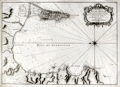 | Details | Bellin, Jacques Nicolas | 1762 |
| Carte de la Baye de Gibraltar |
|
Bellin, Jacques Nicolas |
|
| 1762 |
| LOC:0 |
| $550.00 | Bellin--Jacques-Nicolas | Carte-de-la-Baye-de-Gibraltar | Large, original, antique French sea chart of the Bay and Rock of Gibraltar from 1762. Noted features include the village and mountain of Gibraltar, Fort St. Philippe, Fort St. Roch, Pointe de Mala, Pointe de Roquadillo, the River Entrance Tower ( Tour d'Entre los Rios ), the Admiral's Tower ( Tour de le Amirante ) , Algeciras, Ance de Getare, and Cape Carnero. With numerous soundings, navigational hazards, and anchorages.
<br></br>
Decorative title cartouche attributes the chart to: " le S. Bellin Ingenieur de la Marine Ceuseur Royal & a." |
| 3640 | 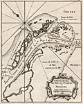 | Details | Bellin, Jacques Nicolas | 1763 |
| Scarce mid eighteenth-century antique map of the Mississippi River passes. |
|
Bellin, Jacques Nicolas |
|
| 1763 |
| LOC:77 |
| $400.00 | Bellin--Jacques-Nicolas | Scarce-mid-eighteenth-century-antique-map-of-the-Mississippi-River-passes- | Very attractive early French maritime map shows the mouth of the "Fleuve St. Louis" or Mississippi River in Louisiana. Noted locations include Passe a la Loutre and Isle de la Fort de Balise.
<br></br>
From J.N. Bellin's <b>Le Petit Atlas Maritime</b> . With soundings at the key passes into the Gulf of Mexico. Lacks latitude and longitude scales. North is oriented to the top left of map. Tome I, No. 38. |
| 4740 | 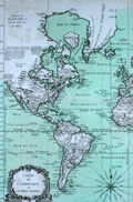 | Details | Bellin, Jacques Nicolas | 1763 |
| Chart Western Hemisphere Petit Altas Maritime |
|
Bellin, Jacques Nicolas |
|
| 1763 |
| LOC:88 |
| $675.00 | Bellin--Jacques-Nicolas | Chart-Western-Hemisphere-Petit-Altas-Maritime | Fine authentic antique chart of the Western Hemisphere by Jacques Nicolas Bellin: "Carte de l'Amerique et des Mers Voisines."
<br></br>
This scarce (12" x 18") copper-plate engraving is from Bellin's "Le Petit Atlas Maritime." Includes North America, South America, west Europe and Africa. Dated within to 1763. |
| 1055 | 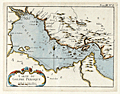 | Details | Bellin, Jacques Nicolas | 1764 |
| Antique French Chart of the Persian Gulf Region |
|
Bellin, Jacques Nicolas |
|
| 1764 |
| LOC:9 |
| $350.00 | Bellin--Jacques-Nicolas | Antique-French-Chart-of-the-Persian-Gulf-Region | Antique French maritime map of the <b>Persian Gulf</b> by the French cartographer Jacques-Nicolas Bellin (1703−72). <b>Qatar</b> is shown as Catura. Cities on both the Arabian and Persian sides of the gulf are indicated, and the map shows a river emptying into the gulf at the port of Julfar (present-day Ra's al-Khaymah, United Arab Emirates). Key features include the islands of "Baharem" (Bahrain), "Ormus" (Hormuz), and "Kimishe" (Qeshm); and the city of Banderabashi (Bandar Abbas, Iran),
<br></br>
From Bellin's "Le Petit Atlas Maritime: Recueil de Cartes et de Plans des Quatre Parties du Monde" (Small maritime atlas: collection of maps and charts of the four parts of the world), in five volumes containing 581 maps in total.
<br></br>
Plate 8, Tome 3. |
| 2535 | 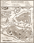 | Details | Bellin, Jacques Nicolas | 1764 |
| Interesting antique plan of Cartagena Colombia |
|
Bellin, Jacques Nicolas |
|
| 1764 |
| LOC:88 |
| $250.00 | Bellin--Jacques-Nicolas | Interesting-antique-plan-of-Cartagena-Colombia | A very interesting plan of the walled city of Cartagena, Colombia in South America with North oriented to the bottom left. Cartagena was an important hub of the Spanish empire in South America. The plan includes a key at top that identifies the important public buildings, numerous churches, powder magazine, prison and fortifications. Unlike other maps and plans of the period this map provides little detail of the hydrographic nature of the surrounding bay.
<br></br>
Cartagena, a major port, was founded in 1533, and named after Cartagena, Spain, which in turn was named after Carthage in Tunisia. Settlement in the region around Cartagena Bay by various indigenous peoples dates back to 4000 BC. During the Spanish colonial period Cartagena served a key role in administration and expansion of the Spanish empire.
<br></br>
From J.N. Bellin's "Le Petit Atlas Maritime: Recueil de Cartes et de Plans des Quatre Parties du Monde" (Small maritime atlas: collection of maps and charts of the four parts of the world), in five volumes containing 581 maps in total. |
| 199 | 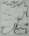 | Details | Bellin, Jacques Nicolas | 1764 |
| Plan de Bayes et Poussole |
|
Bellin, Jacques Nicolas |
|
| 1764 |
| LOC:0 |
| $0.00 | Bellin--Jacques-Nicolas | Plan-de-Bayes-et-Poussole | SOLD
<br></br>
Clean copy of this small 18th century antique chart of the Italian coast including the city of Pozzouli (Poussole) from La Petit Atlas Maritime. Coverage includes the Mediterranean coast from Cap Mizene to Cap Coroille. Highlights include a small volcano "Souffriere" and the island of Nizita south of Pozzouli. Tome 4. No. 85. |
| 198 |  | Details | Bellin, Jacques Nicolas | 1764 |
| Le Port Marianne dans l'Isle de Cube. (Mariel, Cuba) |
|
Bellin, Jacques Nicolas |
|
| 1764 |
| LOC:5 |
| $185.00 | Bellin--Jacques-Nicolas | Le-Port-Marianne-dans-l-Isle-de-Cube--(Mariel--Cuba) | Antique black and white large-scale chart of Mariel harbor in the La Habana province of Cuba. This scarce engraved harbor chart is from Jacque Nicholas Bellin's "La Petit Atlas Maritime". Port of Mariel on the island of Cuba is labeled "Marianne". Mariel is the closest Cuban port to the U.S. Numerous soundings and sparse interior detail, in fact no habitation noted. Very good condition. Tome 1 No. 53. |
| 1305 | 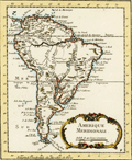 | Details | Bellin, Jacques Nicolas | 1764 |
| South American Continent |
|
Bellin, Jacques Nicolas |
|
| 1764 |
| LOC:5 |
| $215.00 | Bellin--Jacques-Nicolas | South-American-Continent | Fine copper-plate engraved map of South America ca. 1764. Noted features on this attractive, decorative map include the Amazon River, the Malvinas Islands (Falklands), Buenos Aires, Lake Titicaca, Lima, and the islands of Trinidad and Martinique. "Tierra Firme" is the name the Spanish used to denote their overseas possessions on the north coast of South America including present day Colombia.
<br></br>
Published by Nicolas Bellin in his "Petit Atlas Maritime." Volume 2, Number 3. With both latitude and longitude markings. |
| 3675 | 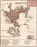 | Details | Bellin, Jacques Nicolas | 1764 |
| Antique chart of the harbor, town, and fort at Plymouth, England |
|
Bellin, Jacques Nicolas |
|
| 1764 |
| LOC:7 |
| $295.00 | Bellin--Jacques-Nicolas | Antique--chart-of-the-harbor--town--and-fort-at-Plymouth--England | Fine mid eighteenth-century French navigation port plan and map of Plymouth, England. By Jacques-Nicolas Bellin. A key with seventeen items provides information on the precise location of important governmental, ecclesiastical, and commercial sites as well a provides the location of major gates or access-control locations. This is a larger-scale plan covering a smaller area than Bellin's related smaller-scale "Carte de la Port de Plimouth" of Plymouth Sound.
<br></br>
From Bellin's <b>Petit Atlas Maritime.</b> Tome IV No 11. |
| 3676 | 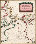 | Details | Bellin, Jacques Nicolas | 1764 |
| Antique chart of Plymouth Sound in England |
|
Bellin, Jacques Nicolas |
|
| 1764 |
| LOC:7 |
| $295.00 | Bellin--Jacques-Nicolas | Antique-chart-of-Plymouth-Sound-in-England | Attractive small French navigation port plan and map of Plymouth Sound and the town of Plymouth, England. By Jacques-Nicolas Bellin. Numerous depth soundings, anchorages, shallow areas, and navigational hazards are noted throughout this fine antique chart.
<br></br>
From Bellin's <b>Petit Atlas Maritime.</b> Tome IV, Number 10. |
| 729 | 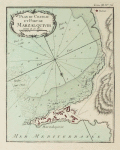 | Details | Bellin, Jacques Nicolas | 1764 |
| Plan du Chateau et Port de Marzalquivir |
|
Bellin, Jacques Nicolas |
|
| 1764 |
| LOC:4 |
| $150.00 | Bellin--Jacques-Nicolas | Plan-du-Chateau-et-Port-de-Marzalquivir | Antique port plan du Chateau et Port de Marzalquivir ( Algeria ) by J.N. Bellin in "Le Petit Atlas Maritime ". Tome 3 Number 76. |
| 3641 | 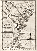 | Details | Bellin, Jacques Nicolas | 1764 |
| Fine mid eighteenth-century antique map of the Georgia coast. |
|
Bellin, Jacques Nicolas |
|
| 1764 |
| LOC:77 |
| $450.00 | Bellin--Jacques-Nicolas | Fine-mid-eighteenth-century-antique-map-of-the-Georgia-coast- | This early French maritime map shows the coast of Georgia in the United States. Coverage ranges from Saint Helena Island in the north to past St. Augustine in the south and includes the road "chemin" linking the two locations. Our copper-plate engraved map includes Augusta, Savannah, Jekyll Island, Talbot Island, Sapelo and Saint Simon's Island in Georgia; and St. Augustine, Florida. Prominently features those rivers which would have been important travel routes to the interior: St. John's River, Altahama River, Ogeechee River and the Savannah River along with many smaller waterways.
<br></br>
From J.N. Bellin's <b>Le Petit Atlas Maritime</b> . With latitude and longitude scales and a large decorative compass rose with rhumb lines. North is oriented to the top of map. Tome I, No. 38. |
| 3642 | 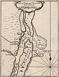 | Details | Bellin, Jacques Nicolas | 1764 |
| Neat French antique map of St. Augustine, Florida and harbor. |
|
Bellin, Jacques Nicolas |
|
| 1764 |
| LOC:87 |
| $400.00 | Bellin--Jacques-Nicolas | Neat-French-antique-map-of-St--Augustine--Florida-and-harbor- | Fine small French navigation chart of the port and harbour of St. Augustine, Florida ca. 1764 from Bellin's "Petit Atlas Maritime". Anastasia Island, directly offshore the harbor is titled "Isle de Matance ou St. Anastasie". Shows the entrance to the harbor encircled by shallow sand-banks with a tower ("balise") serving as a navigational aid. Other features noted by Bellin include an "Eglise des Indiens" or church for native americans; the fort- Castillo de San Marcos; a monastery; the "Riviere Diego" now the Tolomato River; and "Riviere St. Sebastien" .
<br></br>
From J.N. Bellin's master work <b>Le Petit Atlas Maritime</b> . North is oriented to the top. Uncolored. Tome I, No. 39. |
| 1358 | 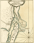 | Details | Bellin, Jacques Nicolas | 1764 |
| Antique mid-eighteenth century chart of the harbor of St. Augustine, Florida |
|
Bellin, Jacques Nicolas |
|
| 1764 |
| LOC:11 |
| $475.00 | Bellin--Jacques-Nicolas | Antique-mid-eighteenth-century-chart-of-the-harbor-of-St--Augustine--Florida | Fine small French navigation chart of the port and harbour of St. Augustine, Florida ca. 1764 from Bellin's "Petit Atlas Maritime". Anastasia Island, directly offshore the harbor is titled "Isle de Matance ou St. Anastasie". Shows the entrance to the harbor encircled by shallow sand-banks with a tower ("balise") serving as a navigational aid. Other features noted by Bellin include an "Eglise des Indiens" or church for native americans; the fort- Castillo de San Marcos; a monastery; the "Riviere Diego" now the Tolomato River; and "Riviere St. Sebastien"
<br></br>
Tome I No 39. |
| 1462 | 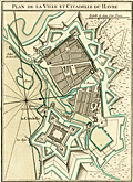 | Details | Bellin, Jacques Nicolas | 1764 |
| Plan of the Fortress and Town of Le Havre France |
|
Bellin, Jacques Nicolas |
|
| 1764 |
| LOC:7 |
| $220.00 | Bellin--Jacques-Nicolas | Plan-of-the-Fortress-and-Town-of-Le-Havre-France | Fine engineer's grade "Plan of the Fortress and Town of Le Havre France". Le Havre lies in France's Normandy region. Shows a Vauban-style fortress, adapted to defend against sustained attack by artillery. By J.N. Bellin 1764 from his Petit Atlas Maritime. Tome 5 No 32. |
| 1158 | 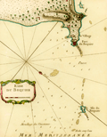 | Details | Bellin, Jacques Nicolas | 1764 |
| Antique engraved chart of the anchorage at Aboukir Bay |
|
Bellin, Jacques Nicolas |
|
| 1764 |
| LOC:6 |
| $265.00 | Bellin--Jacques-Nicolas | Antique-engraved-chart-of-the-anchorage-at-Aboukir-Bay | This colorful antique French chart shows the anchorage ("Mouillage des Vaisseaux") and waters near the "Fort du Bequier" and "Isle du Bequier" at Aboukir ("Bequier"), Egypt. Aboukir lies north of Alexandria on the Mediterranean Sea coast of North Africa.
<br></br>
Aboukir Bay was the site where British Admiral Horatio Nelson fought the naval <b>Battle of the Nile</b> on August 1, 1798 also referred to as the "Battle of Aboukir Bay". Ironically, the French were badly defeated by the British at the battle in part because the British had better information about water depth in the area.
<br></br>
From Bellin's <b>Le Petit Atlas Maritime</b> .
<br></br>Tome III, No 88. |
| 1152 | 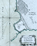 | Details | Bellin, Jacques Nicolas | 1764 |
| Plan du Fort et du Village du Bequier |
|
Bellin, Jacques Nicolas |
|
| 1764 |
| LOC:6 |
| $180.00 | Bellin--Jacques-Nicolas | Plan-du-Fort-et-du-Village-du-Bequier | Shows the village and fort at Aboukir ("Bequier"), Egypt north of Alexandria on the North African coast of the Mediterranean Sea. Aboukir Bay was the site where British Admiral Horatio Nelson fought the naval <b>Battle of the Nile</b> on August 1, 1798 also referred to as the "Battle of Aboukir Bay". From Bellin's <b>Le Petit Atlas Maritime</b> . |
| 1153 | 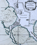 | Details | Bellin, Jacques Nicolas | 1764 |
| Plan des Ports et Ville d'Alexandrie |
|
Bellin, Jacques Nicolas |
|
| 1764 |
| LOC:6 |
| $250.00 | Bellin--Jacques-Nicolas | Plan-des-Ports-et-Ville-d-Alexandrie | This fine maritime chart / plan shows the ancient walled town of <b>Alexandria, Egypt</b> on the North African coast of the Mediterranean Sea. The plan includes both the old port and to the east, the new port.
<br></br>
Includes a representation of <b>Pompey's Pillar</b>. The "Colonne de Pompee" is a 30-meter tall monolithic Roman triumphal column in Alexandria, Egypt, and the largest of its type constructed outside the imperial capitals of Rome and Constantinople. Numerous soundings, hazards, and anchorages attest to the nautical nature of this plan. From Bellin's <b>Le Petit Atlas Maritime</b> .
<br></br>
Tome III No. 86. |
| 1154 | 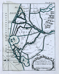 | Details | Bellin, Jacques Nicolas | 1764 |
| Antique chart of the Nile Delta north of Alexandria, Egypt |
|
Bellin, Jacques Nicolas |
|
| 1764 |
| LOC:6 |
| $250.00 | Bellin--Jacques-Nicolas | Antique-chart-of-the-Nile-Delta-north-of-Alexandria--Egypt | Fine antique map of the waterways crisscrossing the Nile delta from Suez west past Alexandria, Egypt. Noted features include: "Lac Mareotis" (Lake Mariout or Maryut); the Isthmus of Suez and upper tip of the Gulf of Suez; "Rosette" (Rosetta, the location of the discovery of the archaeologically important rock stele known as the Rosetta Stone.)
<br></br>
From Bellin's <b>Le Petit Atlas Maritime</b> .Tome III, No. 89. |
| 176 | 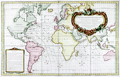 | Details | Bellin, Jacques Nicolas | 1765 |
| Carte des Variations de la Boussole |
|
Bellin, Jacques Nicolas |
|
| 1765 |
| LOC:0 |
| $0.00 | Bellin--Jacques-Nicolas | Carte-des-Variations-de-la-Boussole | NOT AVAILABLE <BR> </BR> Spectacularly decorative antique nautical map of the World from the 'Hydrographie francoise' by Jacques Bellin. Displays compass variation and prevailing wind direction across the globe. Australia is shown with only a partial coastline as "Terres Australis" or "Nouvelle Hollande" and the U.S. Pacific Northwest with no coastal detail.<BR> </BR>
Winds are represented as small cherubs with puffed cheeks. Huge rococo cartouche at right is decorated with cornucopia and numerous floral elements; capped with a crowned globe bearing the three fleur-de-lis that have been an emblem on the French coat of arms from the 14th century. This antique map of the world was produced by J.N. Bellin, the first French "Ingenieur de la Marine" towards the end of his career in 1765. The dedicatory cartouche to the Minister of War, the Duke de Choiseul, is as much a tribute to Bellin as to the minister as it lists his several accomplishments: "Ingenieur de la Marine", "Censeur Royal de l'Academie de Marine et de la Societe Royale de Londres". |
| 1326 | 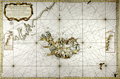 | Details | Bellin, Jacques Nicolas | 1767 |
| Fine antique chart of Iceland and Faroe Islands ... Whaling related |
|
Bellin, Jacques Nicolas |
|
| 1767 |
| LOC:0 |
| $0.00 | Bellin--Jacques-Nicolas | Fine-antique-chart-of-Iceland-and-Faroe-Islands-----Whaling-related | SOLD
<br></br>
Very large antique French sea chart published by France's Depot de la Marine to serve whaling interests near Iceland ("pour servir a la peche de la balaine"). After the work of Horrebows and of Knopf. Contains all of Iceland and portions of the Greenland coast, the Faroe Islands, and Jan Mayen Island. A long stretch of the Greenland coast is noted as speculative: "Toute cette coste n'est tracee que sur des conjectures".
<br></br>
At left an inset correction of a part of Iceland's west coast south of Cap Nord (near today's Hornstrandir Nature Reserve) based on the exploration of Kerguelen in 1707. Inset to right contains coastal details of the east coast of Iceland based on Dutch charts. With a very decorative title cartouche and the circular anchor logo of France's Depot de la Marine. Dated 1767 within but printed ca. 1789 - 1799, based of the "R.F." ( République française ) within the logo.
<br></br>
This scarce and highly decorative chart is annotated with information about re-supply points that could have been useful to whalers and other mariners:
<div class="indenttextblock">
<ul style="list-style-type: circle;">
<li>"Ville et port a viande."</li>
<li>"Ville et port a poisson."</li>
<li>"Ville et port a viande y a aussi boucherie."</li>
<li>"Ville et port ou l'on charge du poisson et de la graisse de poisson."</li>
</ul>
</div>
Contains a diagram noting the high magnetic variation experienced in the area (32 degrees west). Interesting detail is the knitted fisherman's cap directly below the North direction arrow. |
| 719 | 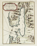 | Details | Bellin, Jacques Nicolas | 1771 |
| Plan of Buccari ( Bakar ) and Porto-Re ( Kraljevica), Croatia |
|
Bellin, Jacques Nicolas |
|
| 1771 |
| LOC:7 |
| $200.00 | Bellin--Jacques-Nicolas | Plan-of-Buccari-(-Bakar-)-and-Porto-Re-(-Kraljevica)--Croatia | Beautifully colored 18th century French antique map / plan of the Bay of Bakar including Buccari, Croatia with Buccariza and Porto-Re, now Kraljevica. A few soundings and anchorages noted and two chateau, but much emphasis on the fortifications and batteries, containing in total 41 cannon. By J.N. Bellin, cartographer for the French Depot de la Marine.
<br></br>Published in Paris (1771) by Didot in "Description géographique du Golfe de Venise et de la Morée : avec des remarques pour la navigation et des cartes et plans des côtes, villes, ports et mouillages". Plate 14. |
| 445 |  | Details | Bellin, Jacques Nicolas | 1772 |
| Hydrographie Francoise (Title Page) |
|
Bellin, Jacques Nicolas |
|
| 1772 |
| LOC:55 |
| $400.00 | Bellin--Jacques-Nicolas | Hydrographie-Francoise-(Title-Page) | Gorgeous copperplate re-strike engraving of the title page to Bellin's sea-atlas, the Hydrographie Francoise. With the circular stamp of the Depot de la Marine. Undated. Price One and one-half francs. No. 1.
<BR> </BR>
We believe the engraving is an early 20th century re-strike from the original copper plate produced at the French Chalcographie du Louvre. La Chalcographie du Louvre is a repository, consisting of more that 13,000 original plates from the Louvre's archives, housed upstairs above the Louvre's Paris galleries . Upon request visitors can have an engraving produced from the original plate on museum-quality paper by a master printer. V.196. |
| 449 |  | Details | Bellin, Jacques Nicolas | 1774 |
| Plan de la Nouvelle Orleans (2) |
|
Bellin, Jacques Nicolas |
|
| 1774 |
| LOC:0 |
| $0.00 | Bellin--Jacques-Nicolas | Plan-de-la-Nouvelle-Orleans-(2) | <BR></BR>
This plate has been SOLD but please see another <a style="color:#0000EE" rel="nofollow" href="https://www.rarecharts.com/ShowDetail/Creator/Bellin--Jacques-Nicolas/Title/Plan-de-la-Nouvelle-Orleans-(3)/1193">hand-colored engraving of Bellin's plan.</a>
<br><br/>
A very desirable map and one of the few maps available from the colonial period, Nicolas Bellin's famous plan of the city of New Orleans, Louisiana is based on a manuscript map created approximately 15 years after the city was founded along high ground on the east bank of the Mississippi river. The plan depicts the city neatly laid out with streets most residents would recognize today including Bourbon, Chartres, Royale and at the center of the plan- Jackson Square.
<BR> </BR>
Copies of this map are increasingly difficult to find and prices have increased substantially since Hurricane Katrina. From "Histoire Generale des Voyages ou Nouvelle Collection de Toutes Relations de Voyages par Mer et par Terre". Published by van Harrevelt and Changuion; Amsterdam. Volume 21.
<BR> </BR>
The plan is based on a design initially created by military engineers Adrien de Pauger and Le Blond de la Tour in 1722. That plan envisioned a street grid extending six blocks northward from the Mississippi River, a plan that was likely scaled back in 1729 as a result of the Natchez Indian massacre of settlers at Fort Rosalie near Natchez Mississippi. At that point security became paramount. This plan by Bellin is more similar to an unsigned manuscript plan of New Orleans from 1732, which showed the city extending only 4 blocks north from the river, and partially surrounded by a defensive moat. The new emphasis on security, when the population totaled less than 2000 persons, is reflected in some of the other features found in Bellin's plan: guardhouses, a powder magazine, and a single bridge controlling access across the moat to the city. Those features were absent in Pauger's plan. |